ATL: GERT - Post-Tropical - Discussion

Moderator: S2k Moderators

Message
Author
User avatar
bvigal
S2K Supporter
S2K Supporter
Posts: 2276
Joined: Sun Jul 24, 2005 8:49 am
Location: British Virgin Islands
Contact:

Re: ATL: INVEST 99L - Discussion

#441 Postby bvigal » Fri Aug 04, 2017 3:43 pm

OuterBanker wrote:It’s amazing. Many are writing this off already. Expecting it to be developed already and since it hasn’t well that must be it for this system. Camille was a tropical wave for eight days before it developed. I don’t think we should be so hasty in writing 99L off quite just yet.


Yeah, way too early to speculate. Not even possible to get a good fix right now, so the runs don't mean much yet. ECarib should keep a watch, further west should relax for a bit.
1 likes   

User avatar
Blown Away
S2K Supporter
S2K Supporter
Posts: 10145
Joined: Wed May 26, 2004 6:17 am

Re: ATL: INVEST 99L - Models

#442 Postby Blown Away » Fri Aug 04, 2017 4:14 pm

18 Track:
Image

18z Intensity:
Image
0 likes   
Hurricane Eye Experience: David 79, Irene 99, Frances 04, Jeanne 04, Wilma 05... EYE COMING MY WAY IN 2024…
Hurricane Brush Experience: Andrew 92, Erin 95, Floyd 99, Matthew 16, Irma 17, Ian 22, Nicole 22…

User avatar
AubreyStorm
Category 1
Category 1
Posts: 337
Age: 44
Joined: Fri Jun 16, 2017 6:21 pm
Location: Texas, USA

Re: ATL: INVEST 99L - Discussion

#443 Postby AubreyStorm » Fri Aug 04, 2017 4:21 pm

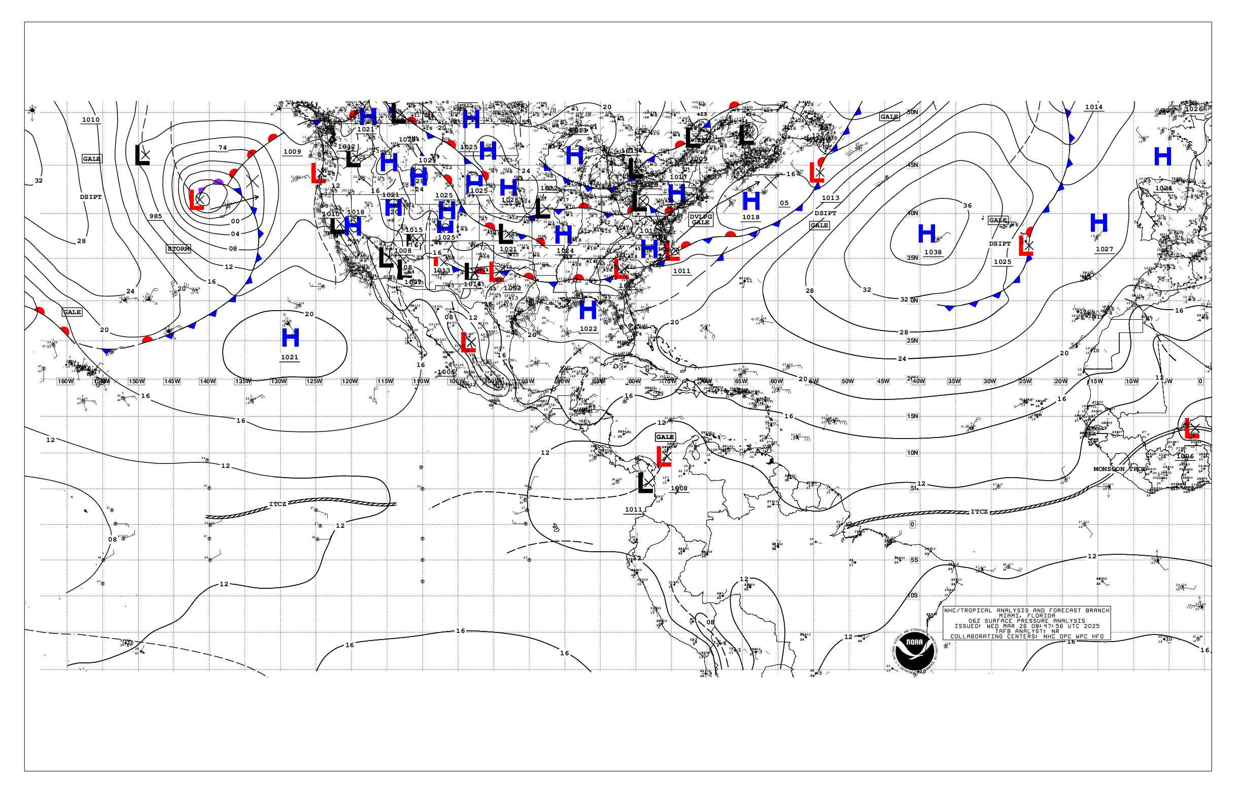
Nice! Only one Lowwww! See below

Image
0 likes   
The posts are NOT an official forecast. Please REFER to the NHC and NWS for official forecasts and products.

AutoPenalti
Category 5
Category 5
Posts: 4030
Age: 29
Joined: Mon Aug 17, 2015 4:16 pm
Location: Ft. Lauderdale, Florida

Re: ATL: INVEST 99L - Discussion

#444 Postby AutoPenalti » Fri Aug 04, 2017 4:35 pm

AubreyStorm wrote:Nice! Only one Lowwww! See below

http://www.nhc.noaa.gov/tafb_latest/USA_latest.gif

Does it really matter in the grand scheme of things?

(Models)
1 likes   
The posts in this forum are NOT official forecasts and should not be used as such. They are just the opinion of the poster and may or may not be backed by sound meteorological data. They are NOT endorsed by any professional institution or STORM2K. For official information, please refer to products from the NHC and NWS.


Model Runs Cheat Sheet:
GFS (5:30 AM/PM, 11:30 AM/PM)
HWRF, GFDL, UKMET, NAVGEM (6:30-8:00 AM/PM, 12:30-2:00 AM/PM)
ECMWF (1:45 AM/PM)

TCVN
is a weighted averaged

User avatar
Blown Away
S2K Supporter
S2K Supporter
Posts: 10145
Joined: Wed May 26, 2004 6:17 am

Re: ATL: INVEST 99L - Models

#445 Postby Blown Away » Fri Aug 04, 2017 4:47 pm

18z GFS... 66hrs ... 1005mb maybe TD... Slightly stronger than 12z...
1 likes   
Hurricane Eye Experience: David 79, Irene 99, Frances 04, Jeanne 04, Wilma 05... EYE COMING MY WAY IN 2024…
Hurricane Brush Experience: Andrew 92, Erin 95, Floyd 99, Matthew 16, Irma 17, Ian 22, Nicole 22…

User avatar
AubreyStorm
Category 1
Category 1
Posts: 337
Age: 44
Joined: Fri Jun 16, 2017 6:21 pm
Location: Texas, USA

Re: ATL: INVEST 99L - Discussion

#446 Postby AubreyStorm » Fri Aug 04, 2017 4:52 pm

AutoPenalti wrote:
AubreyStorm wrote:Nice! Only one Lowwww! See below

http://www.nhc.noaa.gov/tafb_latest/USA_latest.gif

Does it really matter in the grand scheme of things?

(Models)


Absolutely YESSS!
0 likes   
The posts are NOT an official forecast. Please REFER to the NHC and NWS for official forecasts and products.

User avatar
Blown Away
S2K Supporter
S2K Supporter
Posts: 10145
Joined: Wed May 26, 2004 6:17 am

Re: ATL: INVEST 99L - Models

#447 Postby Blown Away » Fri Aug 04, 2017 4:53 pm

18z GFS... 90hrs ... 998mb Strong TS... Decent uptick in intensity compared to 12z... Track about the same...
2 likes   
Hurricane Eye Experience: David 79, Irene 99, Frances 04, Jeanne 04, Wilma 05... EYE COMING MY WAY IN 2024…
Hurricane Brush Experience: Andrew 92, Erin 95, Floyd 99, Matthew 16, Irma 17, Ian 22, Nicole 22…

RL3AO
Moderator-Pro Met
Moderator-Pro Met
Posts: 16308
Joined: Thu Jun 14, 2007 10:03 pm
Location: NC

Re: ATL: INVEST 99L - Discussion

#448 Postby RL3AO » Fri Aug 04, 2017 4:54 pm

If this is going to develop in the next 3 or 4 days, it's gonna need some deep and organized convection tonight. And then it will probably weaken tomorrow. But then it will need to fire more organized convection tomorrow night. If it can do that, it might have a chance of becoming a TD by Monday.
4 likes   

hipshot
Category 2
Category 2
Posts: 591
Joined: Tue Jul 06, 2010 9:18 pm
Location: Dallas, Texas

Re: ATL: INVEST 99L - Discussion

#449 Postby hipshot » Fri Aug 04, 2017 4:57 pm

AubreyStorm wrote:Nice! Only one Lowwww! See below

http://www.nhc.noaa.gov/tafb_latest/USA_latest.gif


Where is 90L in that graphic?
0 likes   

User avatar
Hurricaneman
Category 5
Category 5
Posts: 7351
Age: 45
Joined: Tue Aug 31, 2004 3:24 pm
Location: central florida

Re: ATL: INVEST 99L - Models

#450 Postby Hurricaneman » Fri Aug 04, 2017 4:57 pm

Blown Away wrote:18z GFS... 90hrs ... 998mb Strong TS... Decent uptick in intensity compared to 12z... Track about the same...

Maybe a tic south, might be able to miss Hispaniola to the south if that happens
1 likes   

RL3AO
Moderator-Pro Met
Moderator-Pro Met
Posts: 16308
Joined: Thu Jun 14, 2007 10:03 pm
Location: NC

Re: ATL: INVEST 99L - Discussion

#451 Postby RL3AO » Fri Aug 04, 2017 4:57 pm

hipshot wrote:Where is 90L in that graphic?


The tropical wave over the central Caribbean
0 likes   

User avatar
SouthFLTropics
Category 5
Category 5
Posts: 4236
Age: 50
Joined: Thu Aug 14, 2003 8:04 am
Location: Port St. Lucie, Florida

Re: ATL: INVEST 99L - Models

#452 Postby SouthFLTropics » Fri Aug 04, 2017 5:01 pm

Hurricaneman wrote:
Blown Away wrote:18z GFS... 90hrs ... 998mb Strong TS... Decent uptick in intensity compared to 12z... Track about the same...

Maybe a tic south, might be able to miss Hispaniola to the south if that happens


If it develops sooner then it may move more poleward. We'll see what the model shows.
0 likes   
Fourth Generation Florida Native

Personal Storm History: David 79, Andrew 92, Erin 95, Floyd 99, Irene 99, Frances 04, Jeanne 04, Wilma 05, Matthew 16, Irma 17, Ian 22, Nicole 22, Milton 24

Alyono
Professional-Met
Professional-Met
Posts: 6961
Joined: Fri Apr 26, 2013 3:52 pm
Location: Texas Coast

Re: ATL: INVEST 99L - Models

#453 Postby Alyono » Fri Aug 04, 2017 5:01 pm

18Z GFS shows a sheared system

Conditions according to the models will be MORE HOSTILE as this approaches the Caribbean. It has its most favorable conditions now
0 likes   

User avatar
Blown Away
S2K Supporter
S2K Supporter
Posts: 10145
Joined: Wed May 26, 2004 6:17 am

Re: ATL: INVEST 99L - Models

#454 Postby Blown Away » Fri Aug 04, 2017 5:02 pm

18z GFS... 108hrs ... 1002mb Likely Moderate TS... Intensity now about same as 12z... Track a hair SW of 12z... Ridging maybe slightly weaker than 12z, not real sure..
1 likes   
Hurricane Eye Experience: David 79, Irene 99, Frances 04, Jeanne 04, Wilma 05... EYE COMING MY WAY IN 2024…
Hurricane Brush Experience: Andrew 92, Erin 95, Floyd 99, Matthew 16, Irma 17, Ian 22, Nicole 22…

User avatar
Blown Away
S2K Supporter
S2K Supporter
Posts: 10145
Joined: Wed May 26, 2004 6:17 am

Re: ATL: INVEST 99L - Models

#455 Postby Blown Away » Fri Aug 04, 2017 5:08 pm

18z GFS... 150hrs ... TS status... Moving just N of PR... Little stronger and NW of 12z position... Moving just N of due W, DR in crosshairs??
Last edited by Blown Away on Fri Aug 04, 2017 5:14 pm, edited 2 times in total.
0 likes   
Hurricane Eye Experience: David 79, Irene 99, Frances 04, Jeanne 04, Wilma 05... EYE COMING MY WAY IN 2024…
Hurricane Brush Experience: Andrew 92, Erin 95, Floyd 99, Matthew 16, Irma 17, Ian 22, Nicole 22…

User avatar
gatorcane
S2K Supporter
S2K Supporter
Posts: 23691
Age: 47
Joined: Sun Mar 13, 2005 3:54 pm
Location: Boca Raton, FL

Re: ATL: INVEST 99L - Models

#456 Postby gatorcane » Fri Aug 04, 2017 5:13 pm

Looks like it might head just north of Puerto Rico on this run so has shifted north from 12Z

Image
1 likes   

User avatar
Blown Away
S2K Supporter
S2K Supporter
Posts: 10145
Joined: Wed May 26, 2004 6:17 am

Re: ATL: INVEST 99L - Models

#457 Postby Blown Away » Fri Aug 04, 2017 5:16 pm

18z GFS... 186hrs ... Strong TS... Just N of Cuba moving WNW...
Last edited by Blown Away on Fri Aug 04, 2017 5:23 pm, edited 2 times in total.
0 likes   
Hurricane Eye Experience: David 79, Irene 99, Frances 04, Jeanne 04, Wilma 05... EYE COMING MY WAY IN 2024…
Hurricane Brush Experience: Andrew 92, Erin 95, Floyd 99, Matthew 16, Irma 17, Ian 22, Nicole 22…

User avatar
SFLcane
S2K Supporter
S2K Supporter
Posts: 10163
Age: 47
Joined: Sat Jun 05, 2010 1:44 pm
Location: Lake Worth Florida

Re: ATL: INVEST 99L - Models

#458 Postby SFLcane » Fri Aug 04, 2017 5:22 pm

Stair stepping might go into the gulf.
0 likes   

User avatar
Blown Away
S2K Supporter
S2K Supporter
Posts: 10145
Joined: Wed May 26, 2004 6:17 am

Re: ATL: INVEST 99L - Models

#459 Postby Blown Away » Fri Aug 04, 2017 5:25 pm

18z GFS... 204hrs ... Cat 1/2 Hurricane... Just N of Cuba's E coast moving WNW towards SFL/Keys/GOM???
Last edited by Blown Away on Fri Aug 04, 2017 5:30 pm, edited 2 times in total.
0 likes   
Hurricane Eye Experience: David 79, Irene 99, Frances 04, Jeanne 04, Wilma 05... EYE COMING MY WAY IN 2024…
Hurricane Brush Experience: Andrew 92, Erin 95, Floyd 99, Matthew 16, Irma 17, Ian 22, Nicole 22…

User avatar
Siker
Category 4
Category 4
Posts: 904
Age: 28
Joined: Thu Oct 25, 2012 7:36 pm
Location: Miami, FL

Re: ATL: INVEST 99L - Models

#460 Postby Siker » Fri Aug 04, 2017 5:27 pm

Alyono wrote:18Z GFS shows a sheared system

Conditions according to the models will be MORE HOSTILE as this approaches the Caribbean. It has its most favorable conditions now


UKMET actually has this as a weak TD before strengthening near the islands, about 75 miles north of the islands. You don't have access to non-public UKMET data, right?
0 likes   


Return to “2017”

Who is online

Users browsing this forum: No registered users and 0 guests