
ATL: GERT - Post-Tropical - Discussion
Moderator: S2k Moderators
-
gatorcane

- S2K Supporter

- Posts: 23708
- Age: 48
- Joined: Sun Mar 13, 2005 3:54 pm
- Location: Boca Raton, FL
Re: ATL: INVEST 99L - Discussion
Last visible loop before sun goes down with popcorn convection starting:
0 likes

Re: ATL: INVEST 99L - Discussion
TheStormExpert wrote:Smells like 2013 all over again.
https://twitter.com/pppapin/status/893915338567450624
I think you may have drawn this comparison 2013 times already. It would still almost assuredly be wrong on the 2014th. Haha. I just don't see it.
1 likes
-
TheStormExpert
Re: ATL: INVEST 99L - Discussion
Anticyclone building overhead, wind-shear should be low until it approaches the NE Caribbean, SAL starting to clear out some, and 850mb vorticity building about 9N, 36W which is too far south of the thunderstorm activity. Add in the unfavorable Atlantic background forcing and you likely have little to no chance of this amounting to much anytime soon.


0 likes
-
TheStormExpert
Re: ATL: INVEST 99L - Discussion
Steve wrote:TheStormExpert wrote:Smells like 2013 all over again.
https://twitter.com/pppapin/status/893915338567450624
I think you may have drawn this comparison 2013 times already. It would still almost assuredly be wrong on the 2014th. Haha. I just don't see it.
Did you read the comments below the tweet?
1 likes
-
stormreader
Re: ATL: INVEST 99L - Discussion
gatorcane wrote:Last visible loop before sun goes down with popcorn convection starting:
And on the infrared. And as many have noted, it does look better. I mean it might surprise overnight. Possible that by tomorrow we have a different outlook on this feature.

1 likes
-
AubreyStorm

- Category 1

- Posts: 337
- Age: 45
- Joined: Fri Jun 16, 2017 6:21 pm
- Location: Texas, USA
ATL: INVEST 99L - Discussion
ECMWF ensembles more aggressive with #Invest99L
Here we go!
Here we go!
1 likes
The posts are NOT an official forecast. Please REFER to the NHC and NWS for official forecasts and products.
-
txwatcher91
- Category 5

- Posts: 1498
- Joined: Tue Aug 02, 2005 2:29 pm
Re: ATL: INVEST 99L - Discussion
AJC3 wrote:txwatcher91 wrote:Vorticity is becoming a bit stronger and the axis is beginning to consolidate better now. It could begin organizing tonight if trends continue.
Two things you would look for toward that end...
1) Obviously, consolidating of the vorticity, higher values. Thunderstorms along the central and southern flank of the wave axis would help increase convergence and thus vorticity.
2) Also, the wave axis trending toward more of a neutral tilt with time. From strictly a fluid mechanics standpoint, the environment needs to be favorable so that deformation stress can push the northern flank of the wave axis forward relative to the rest of the wave. In other words, the ambient easterly component to the wind flow needs to be stronger, the farther north along the wave axis you go, for the entire length of its axis. This would increase convergence as well.
So far, this hasn't occurred enough to allow the wave to organize. Also, it seems to me that the overall thermodynamic environment hasn't been all that great this far, as has been pointed out by others several times.
Looking through the CIMSS data, the wave axis has been trending closer to a neutral tilt and the vorticity as well. I think that’s why we are finally seeing some convection starting to build. A long ways to go though, we will see what happens tonight.
0 likes
Re: ATL: INVEST 99L - Discussion
Yeah I did. But I never said I ever thought 99L would do anything for a while anyway, so that's not really a surprise to me. The outlier ideas came from the GFS and even more so the CMC with the recurve between the US and Bermuda. I distinctly recall discussing the GFS output on this system with Frank2, where I said the GFS would likely keep tending west like it does earlier in the year. And I said today that I didn't expect anything until 75W if ever. So again, I'm not disagreeing with Michael. I'm just amused by how badly you seem to want 2017 to Parallel 2013. I still think 2004 and maybe in some ways 95 and maybe even a hint of 88 all end up better analogs from recent years. One or possibly both of us will be dead wrong.
0 likes

-
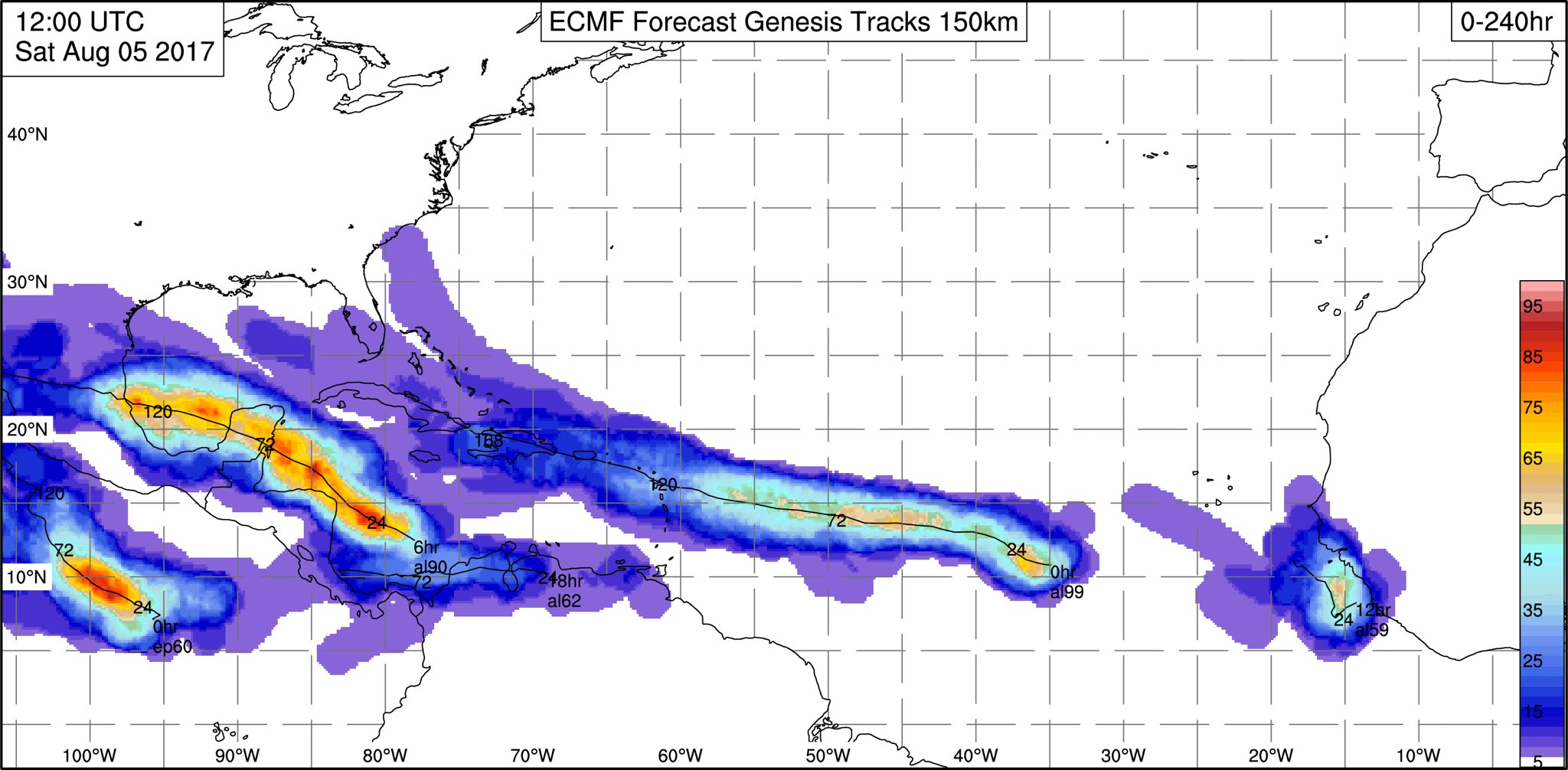
Kingarabian

- S2K Supporter
- Posts: 16364
- Joined: Sat Aug 08, 2009 3:06 am
- Location: Honolulu, Hawaii
Re: ATL: INVEST 99L - Discussion
AubreyStorm wrote:ECMWF ensembles more aggressive with #Invest99L
Here we go!
[img]https://pbs.twimg.com/media/DGfqZMiWsAEO1CZ.jpg:large[img]
Less than 5% support for a TS for 99L throughout 240 hours per the 12z EPS.
0 likes
RIP Kobe Bryant

Re: ATL: INVEST 99L - Discussion
TheStormExpert wrote:Steve wrote:TheStormExpert wrote:Smells like 2013 all over again.
https://twitter.com/pppapin/status/893915338567450624
I think you may have drawn this comparison 2013 times already. It would still almost assuredly be wrong on the 2014th. Haha. I just don't see it.
Did you read the comments below the tweet?
All it means is that others have a similarly wrong idea.
1 likes
The above post is not official and should not be used as such. It is the opinion of the poster and may or may not be backed by sound meteorological data. It is not endorsed by any professional institution or storm2k.org. For official information, please refer to the NHC and NWS products.
-
Emmett_Brown

- Category 5
- Posts: 1433
- Joined: Wed Aug 24, 2005 9:10 pm
- Location: Sarasota FL
Re: ATL: INVEST 99L - Models
gatorcane wrote:12Z UKMET with development again with west turn at the end:

This is an interesting solution. I wonder what causes the more northerly component of motion in the near term. Perhaps interacting with an upper low creates the northward component. The 12Z GFS has a stout ridge off of the US E coast at after 150 hours. Assuming this formed, it could continue W long enough to threaten land.
0 likes

Re: ATL: INVEST 99L - Discussion
OuterBanker wrote:Just an observation. Seems to me that something is trying to organize around 12n 37w ...
Convection is increasing at those coordinates. Should be an interesting night.
1 likes
-
StormTracker

- S2K Supporter
- Posts: 2909
- Age: 59
- Joined: Thu Jun 29, 2006 6:06 am
- Location: Quail Heights(Redlands), FL.
Re: ATL: INVEST 99L - Discussion
Just give 99L some time. Remember, patience is a virtue! I think we're all going to look back on this discussion and feel some kind of way when this system does whatever it does...ST 
1 likes
Something's wrong when you regret, things that haven't happened yet!
-
cycloneye

- Admin

- Posts: 149473
- Age: 69
- Joined: Thu Oct 10, 2002 10:54 am
- Location: San Juan, Puerto Rico
Re: ATL: INVEST 99L - Discussion
Looking better.Let's see if DMAX helps it more.

0 likes
Visit the Caribbean-Central America Weather Thread where you can find at first post web cams,radars
and observations from Caribbean basin members Click Here
and observations from Caribbean basin members Click Here
Re: ATL: INVEST 99L - Discussion
StormTracker wrote:Just give 99L some time. Remember, patience is a virtue! I think we're all going to look back on this discussion and feel some kind of way when this system does whatever it does...ST
I'm still thinking this will at least spin up into a depression but not sure when--the models have certainly backed off on development, but at the same time the organization isn't decreasing any.
1 likes
The above post is not official and should not be used as such. It is the opinion of the poster and may or may not be backed by sound meteorological data. It is not endorsed by any professional institution or storm2k.org. For official information, please refer to the NHC and NWS products.
-
floridasun78
- Category 5
- Posts: 3755
- Joined: Sun May 17, 2009 10:16 pm
- Location: miami fl
Re: ATL: INVEST 99L - Discussion
i think we need see how wave do next few days i think this one we need watch
2 likes
-
cycloneye
- Admin
- Posts: 149473
- Age: 69
- Joined: Thu Oct 10, 2002 10:54 am
- Location: San Juan, Puerto Rico
Re: ATL: INVEST 99L - Discussion
8 PM TWO 30%-50%
Shower activity associated with an elongated area of low pressure
located about 1000 miles west-southwest of the Cabo Verde Islands
has become a little better organized during the past 24 hours.
Some additional slow development is possible during the next two to
three days before the system encounters less favorable
environmental conditions during the middle part of next week. This
system is expected to move generally west-northwestward across the
tropical Atlantic Ocean at about 15 mph.
* Formation chance through 48 hours...low...30 percent.
* Formation chance through 5 days...medium...50 percent.
1 likes
Visit the Caribbean-Central America Weather Thread where you can find at first post web cams,radars
and observations from Caribbean basin members Click Here
and observations from Caribbean basin members Click Here
-
AtlanticWind

- S2K Supporter
- Posts: 1898
- Age: 67
- Joined: Sun Aug 08, 2004 9:57 pm
- Location: Plantation,Fla
Re: ATL: INVEST 99L - Discussion
Kinda funny, the models now have backed off development significantly and
and the system is finally looking like it is forming.Has some convection and
is becoming more circular. Also spin is definitely evident tonight.
and the system is finally looking like it is forming.Has some convection and
is becoming more circular. Also spin is definitely evident tonight.
5 likes
-
tarheelprogrammer

- S2K Supporter
- Posts: 1793
- Joined: Mon Mar 28, 2016 9:25 pm
- Location: Raleigh, NC area (Garner, NC)
Re: ATL: INVEST 99L - Discussion
Actually, there is more vorticity with 99L than 90L currently. It has been consolidating all day long just like 90L.

2 likes
My posts are not official forecasts. They are just my opinion and may or may not be backed by sound meteorological data. They are NOT endorsed by any professional institution or storm2k.org. For official information, please refer to the NHC and NWS products.
Who is online
Users browsing this forum: No registered users and 85 guests