Texas Summer 2017
Moderator: S2k Moderators
Forum rules
The posts in this forum are NOT official forecast and should not be used as such. They are just the opinion of the poster and may or may not be backed by sound meteorological data. They are NOT endorsed by any professional institution or STORM2K.
- srainhoutx
- S2K Supporter

- Posts: 6919
- Age: 68
- Joined: Sun Jan 14, 2007 11:34 am
- Location: Haywood County, NC
- Contact:
Re: Texas Summer 2017
Just emptied 5.11 inches out of the old rain bucket since 4:00 PM yesterday added to the previous 24 hour total of 1.83 making a total for 38 hours of 6.94 inches of rainfall in NW Harris County.
1 likes
Carla/Alicia/Jerry(In The Eye)/Michelle/Charley/Ivan/Dennis/Katrina/Rita/Wilma/Ike/Harvey
Member: National Weather Association
Wx Infinity Forums
http://wxinfinity.com/index.php
Facebook.com/WeatherInfinity
Twitter @WeatherInfinity
Member: National Weather Association
Wx Infinity Forums
http://wxinfinity.com/index.php
Facebook.com/WeatherInfinity
Twitter @WeatherInfinity
-
Yukon Cornelius
- S2K Supporter

- Posts: 1842
- Age: 42
- Joined: Thu Dec 20, 2012 9:23 pm
- Location: Dean, TX/Westcliffe, CO
Re: Texas Summer 2017
66 for a low this morning. Also, noticed another decrease in rain chances for the rest of the week.
0 likes
#neversummer
-
weatherdude1108
- Category 5

- Posts: 4228
- Joined: Tue Dec 13, 2011 1:04 pm
- Location: Northwest Austin/Cedar Park, TX
Re: Texas Summer 2017
I got 3.00 inches in my rain gauge from yesterday. That is the most rain in one day I have had in months.

2 likes
The preceding post is NOT an official forecast, and should not be used as such. It is only the opinion of the poster and may or may not be backed by sound meteorological data. It is NOT endorsed by any professional institution including storm2k.org. For Official Information please refer to the NHC and NWS products.
Re: Texas Summer 2017
Fog, drizzle and 70's on August 8? Whatever... enjoying it while it lasts. 

0 likes
- TeamPlayersBlue
- Category 5

- Posts: 3531
- Joined: Tue Feb 02, 2010 1:44 am
- Location: Denver/Applewood, CO
Re: Texas Summer 2017
Those storms meant business in the middle of the night. I escaped with only a bit over an inch. Where can i go to look at old radar archives? I want to see how it came through last night. Thank you in advance!
0 likes
Personal Forecast Disclaimer:
The posts in this forum are NOT official forecast and should not be used as such. They are just the opinion of the poster and may or may not be backed by sound meteorological data. They are NOT endorsed by any professional institution or storm2k.org. For official information, please refer to the NHC and NWS products.
The posts in this forum are NOT official forecast and should not be used as such. They are just the opinion of the poster and may or may not be backed by sound meteorological data. They are NOT endorsed by any professional institution or storm2k.org. For official information, please refer to the NHC and NWS products.
-
weatherdude1108
- Category 5

- Posts: 4228
- Joined: Tue Dec 13, 2011 1:04 pm
- Location: Northwest Austin/Cedar Park, TX
Re: Texas Summer 2017
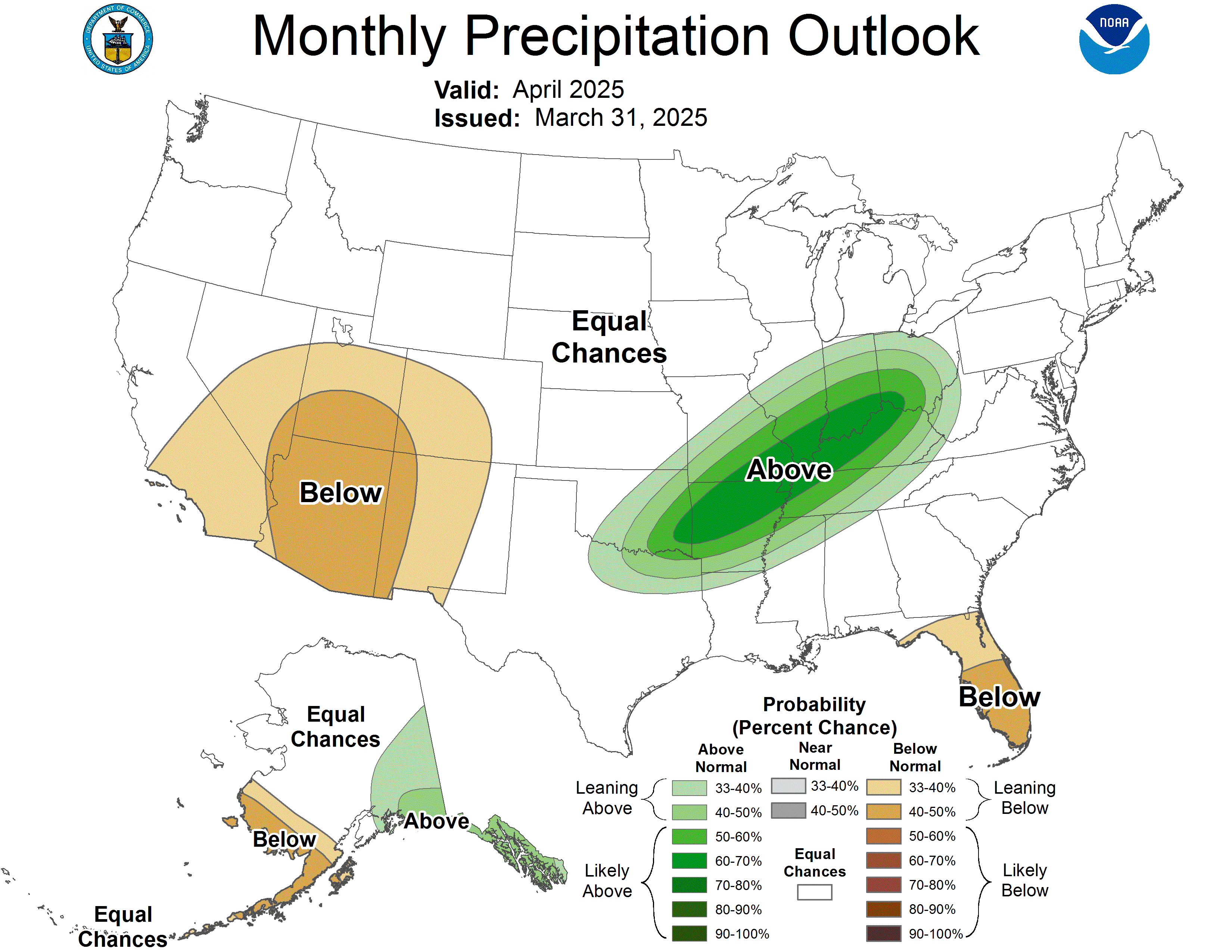
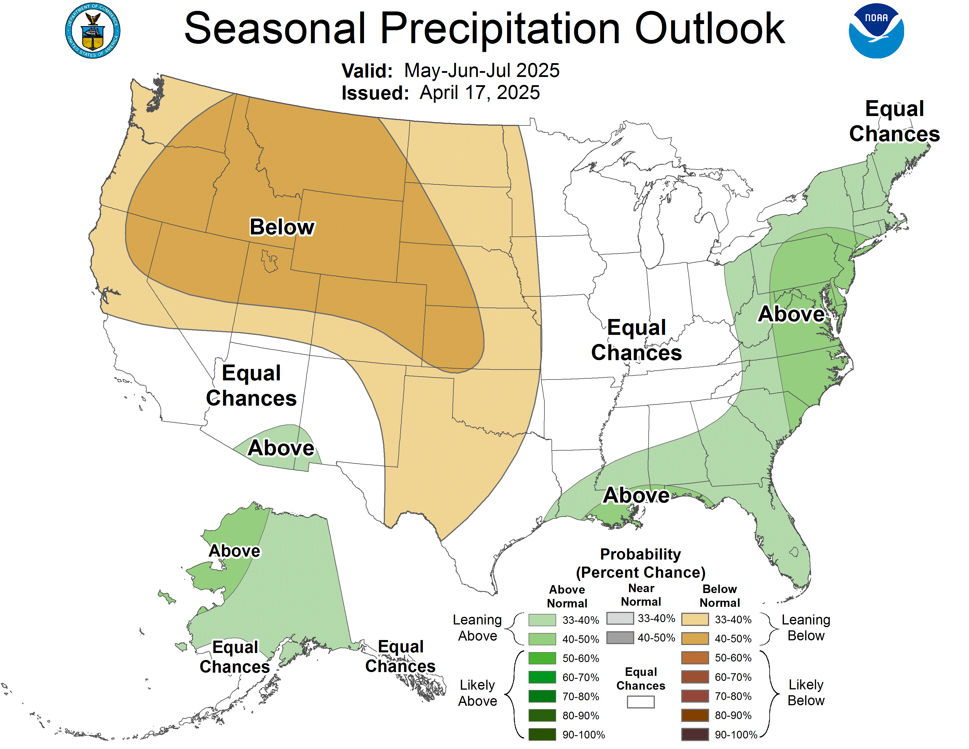
Encouraging rain outlook from the CPC:
Week 3-4 Outlook

One-Month Outlook

Three-Month Outlook

Week 3-4 Outlook

One-Month Outlook

Three-Month Outlook

1 likes
The preceding post is NOT an official forecast, and should not be used as such. It is only the opinion of the poster and may or may not be backed by sound meteorological data. It is NOT endorsed by any professional institution including storm2k.org. For Official Information please refer to the NHC and NWS products.
-
Brent
- S2K Supporter

- Posts: 38757
- Age: 37
- Joined: Sun May 16, 2004 10:30 pm
- Location: Tulsa Oklahoma
- Contact:
Re: Texas Summer 2017
apparently for DFW coolest first week of August since 1997. Even 1997 hit 100 once but had days in the 70s.
tick tock fall is coming.
tick tock fall is coming.
0 likes
#neversummer
Re: Texas Summer 2017
I'm a winter kind of guy so I rarely visit in the summer but I have been enjoying this rainy and cool August! Hoping the coolness now is a sign of things to come!
1 likes
Graduate Meteorology Student at the University of Oklahoma!
All opinions independent of employers and the university.
All opinions independent of employers and the university.
Re: Texas Summer 2017
Anyone want to enlighten me on when the next decent rain event for central and SETX is forecast? I don't see anything anytime soon.
0 likes
-
Brent
- S2K Supporter

- Posts: 38757
- Age: 37
- Joined: Sun May 16, 2004 10:30 pm
- Location: Tulsa Oklahoma
- Contact:
Re: Texas Summer 2017
0z GFS DFW
16 day TOTAL PRECIP: 0 " and Convective: 0 "
Summer comes back with a vengeance. 100s as early as this weekend all through the end of the run
16 day TOTAL PRECIP: 0 " and Convective: 0 "
Summer comes back with a vengeance. 100s as early as this weekend all through the end of the run
0 likes
#neversummer
Re: Texas Summer 2017
I hope that forecast is wrong. But if it does happen it does fit the bill of Atlantic TCs turning the playing field without effecting us
0 likes
The above post and any post by Ntxw is NOT an official forecast and should not be used as such. It is just the opinion of the poster and may or may not be backed by sound meteorological data. It is NOT endorsed by any professional institution including Storm2k. For official information, please refer to NWS products.
Re: Texas Summer 2017
Despite the cpc outlook, it doesn't look like we will see much rain for the foreseeable future in this part of the state. Hopefully this dry spell will not be as persistent as the one through June and July. Starting to look at indicators for Autumn.
0 likes
Resident Rain Miser
I am a weather hobbyist living 3.5 miles south of Downtown Austin and in no way or fashion should anything I say concerning forecasts be taken seriously. Please check your local NWS for accurate weather forecasting and conditions.
I am a weather hobbyist living 3.5 miles south of Downtown Austin and in no way or fashion should anything I say concerning forecasts be taken seriously. Please check your local NWS for accurate weather forecasting and conditions.
-
weatherdude1108
- Category 5

- Posts: 4228
- Joined: Tue Dec 13, 2011 1:04 pm
- Location: Northwest Austin/Cedar Park, TX
Re: Texas Summer 2017
This is depressing. 
000
FXUS64 KEWX 092003
AFDEWX
Area Forecast Discussion
National Weather Service Austin/San Antonio TX
303 PM CDT Wed Aug 9 2017
.SHORT TERM (Tonight through Thursday Night)...
Radar continues to indicate isolated to scattered showers forming
over areas generally south of I-10 this afternoon, and coverage is
enough to warrant a pre-first period wording in the zones. Coverage
should retreat southward more significantly on Thursday as the upper
ridge axis expands southeast over Central TX.
Temps for today are on track to fall shy of previously predicted
highs, with only a few spots along/east of I-35 to see the triple
digit heat indices. This should correct closer to blended guidances
for Thursday as the upper ridge strengthens over TX and ground
moisture continues to escape into the atmosphere.
&&
.LONG TERM (Friday through Wednesday)...
Medium range trends are drier and showing warmer highs in the long
range, suggesting several days of 100 to 108 heat indices. Ambient
high temperatures in the metro areas are probably just a few days
away from returning to triple digits. While a widespread solid rain
of 2-4 inches would normally add to the greenness and further slow
down the day-to-day rate of temperature increases, a lot of the
vegetation went dormant over all the hot and dry days and will
respond more slowly to the moisture. Will continue to shy away from
the idea that rain chances will enter our northern counties around
Sunday, and show only a few showers or storms over the far eastern
counties Friday and Tuesday.
0 likes
The preceding post is NOT an official forecast, and should not be used as such. It is only the opinion of the poster and may or may not be backed by sound meteorological data. It is NOT endorsed by any professional institution including storm2k.org. For Official Information please refer to the NHC and NWS products.
Re: Texas Summer 2017
Franklin going into MX seems to have signaled a change away from the cooler pattern and back to more typical August heat. It's a localized hear ridge over TX above the storm building with subsidence. While cool anomalies continue to the north.
0 likes
The above post and any post by Ntxw is NOT an official forecast and should not be used as such. It is just the opinion of the poster and may or may not be backed by sound meteorological data. It is NOT endorsed by any professional institution including Storm2k. For official information, please refer to NWS products.
-
weatherguy425
- Tropical Storm

- Posts: 180
- Joined: Sun Aug 16, 2009 1:06 pm
- Location: Houston, TX > Lubbock, TX > Savannah, GA
- Contact:
Re: Texas Summer 2017
Ntxw wrote:Franklin going into MX seems to have signaled a change away from the cooler pattern and back to more typical August heat. It's a localized hear ridge over TX above the storm building with subsidence. While cool anomalies continue to the north.
I know there was ridging along the Gulf Coast, but truly hard to get a tropical system that far south, this far north, especially this 'early' in hurricane season; August. Some signs that upcoming ridging will be fairly transient; a week or so. Also will be interesting to watch stalling frontal boundary just to the north of TX. Odds are daily convection pushes it just a bit further south that currently modeled [particularly GFS]... as happened with our last front.
0 likes
Re: Texas Summer 2017
weatherguy425 wrote:Ntxw wrote:Franklin going into MX seems to have signaled a change away from the cooler pattern and back to more typical August heat. It's a localized hear ridge over TX above the storm building with subsidence. While cool anomalies continue to the north.
I know there was ridging along the Gulf Coast, but truly hard to get a tropical system that far south, this far north, especially this 'early' in hurricane season; August. Some signs that upcoming ridging will be fairly transient; a week or so. Also will be interesting to watch stalling frontal boundary just to the north of TX. Odds are daily convection pushes it just a bit further south that currently modeled [particularly GFS]... as happened with our last front.
Even if the system had come through, it still likely would have signaled a pattern change since TC bring heat up from the tropics. The fact that we got little rain from it and likely subsidence now doesn't help. That's the card usually dealt with when looking at the Atlantic, it just doesn't benefit us often times opposite unless you are east of the Mississippi or if you get a direct landfall for rains
0 likes
The above post and any post by Ntxw is NOT an official forecast and should not be used as such. It is just the opinion of the poster and may or may not be backed by sound meteorological data. It is NOT endorsed by any professional institution including Storm2k. For official information, please refer to NWS products.
-
weatherguy425
- Tropical Storm

- Posts: 180
- Joined: Sun Aug 16, 2009 1:06 pm
- Location: Houston, TX > Lubbock, TX > Savannah, GA
- Contact:
Re: Texas Summer 2017
Ntxw wrote:weatherguy425 wrote:Ntxw wrote:Franklin going into MX seems to have signaled a change away from the cooler pattern and back to more typical August heat. It's a localized hear ridge over TX above the storm building with subsidence. While cool anomalies continue to the north.
I know there was ridging along the Gulf Coast, but truly hard to get a tropical system that far south, this far north, especially this 'early' in hurricane season; August. Some signs that upcoming ridging will be fairly transient; a week or so. Also will be interesting to watch stalling frontal boundary just to the north of TX. Odds are daily convection pushes it just a bit further south that currently modeled [particularly GFS]... as happened with our last front.
Even if the system had come through, it still likely would have signaled a pattern change since TC bring heat up from the tropics. The fact that we got little rain from it and likely subsidence now doesn't help. That's the card usually dealt with when looking at the Atlantic, it just doesn't benefit us often times opposite unless you are east of the Mississippi or if you get a direct landfall for rains
Totally get what you're saying. But, subsidence from a tropical system is something that can be tracked and is 9/10 could nfined to a certain place and distance away from a system. Ridging contributed to it landfalling south, rather than Franklin pumping up ridging. In fact, coastal PWATS may briefly rise as SE flow resumes.
0 likes
- Portastorm
- Storm2k Moderator

- Posts: 9955
- Age: 63
- Joined: Fri Jul 11, 2003 9:16 am
- Location: Round Rock, TX
- Contact:
Re: Texas Summer 2017
Here's all you need to know about the next week or so in Texas weather:
The large upper ridge is expected to anchor over TX through the next
10 days.
-- NWSFO Austin/San Antonio, 8/10 afternoon forecast discussion
The large upper ridge is expected to anchor over TX through the next
10 days.
-- NWSFO Austin/San Antonio, 8/10 afternoon forecast discussion
0 likes
Any forecasts under my name are to be taken with a grain of salt. Get your best forecasts from the National Weather Service and National Hurricane Center.
Re: Texas Summer 2017
We're about to be in the frying pan for a while. CPC 6-10 and 8-14 day forecast do not look good.
0 likes
Re: Texas Summer 2017
Yep, slow traffic in the summer thread is never a good thing. On a happier note, in about a week the averages start to decline until January. Baby steps.
1 likes
Return to “USA & Caribbean Weather”
Who is online
Users browsing this forum: AnnularCane, South Texas Storms and 34 guests


