ATL: FRANKLIN - Remnants - Discussion
Moderator: S2k Moderators
Re: ATL: FRANKLIN - Tropical Storm - Discussion
if it keeps intensifying at its current rate, probably around 975-970mb at landfall. Could be similar to Gert
2 likes
-
otowntiger
- Category 5

- Posts: 1932
- Joined: Tue Aug 31, 2004 7:06 pm
Re: ATL: FRANKLIN - Tropical Storm - Discussion
Not a hurricane yet????!!???wxman57 wrote:Nope - still a tropical storm. Recon could not find any hurricane-force winds at the surface.
Season cancel.
1 likes

Re: ATL: FRANKLIN - Tropical Storm - Discussion
Alyono wrote:if it keeps intensifying at its current rate, probably around 975-970mb at landfall. Could be similar to Gert
It's wrapping up pretty nicely now. And with 12 hours to go, I guess 970mb isn't as remote as I thought. It's the absolute low end though short of a stall which doesn't look likely.
0 likes
Re: ATL: FRANKLIN - Tropical Storm - Discussion
Tightening up...Going for it no doubt...
Dry air mixed out...Hazy eye becoming apparent...
Dry air mixed out...Hazy eye becoming apparent...
0 likes

Re: ATL: FRANKLIN - Tropical Storm - Discussion
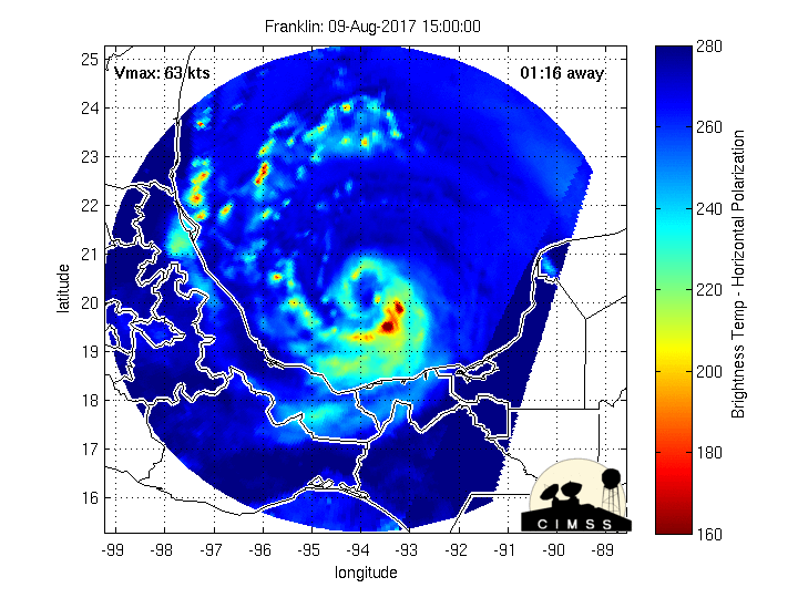
Strongest towers to date now firing off as depicted by the cold tops in yellow.

0 likes
Re: ATL: FRANKLIN - Tropical Storm - Discussion
Right on schedule with COAMPS forecasting a spike in Latent Heat / Enthalpy flux - impressive to say the least.
Looks like those towers are very hot and clearing out an eye.
COAMPS even called out the correct position relative to the CoC.
Looks like those towers are very hot and clearing out an eye.
COAMPS even called out the correct position relative to the CoC.
1 likes


-
Hypercane_Kyle

- Category 5
- Posts: 3465
- Joined: Sat Mar 07, 2015 7:58 pm
- Location: Cape Canaveral, FL
Re: ATL: FRANKLIN - Tropical Storm - Discussion
18z models ran on Franklin as a 65 knot hurricane.
Location: 20.1°N 94.4°W
Maximum Winds: 65 kt Gusts: N/A
Minimum Central Pressure: 984 mb
Environmental Pressure: 1008 mb
Radius of Circulation: 150 NM
Radius of Maximum Wind: 30 NM
Eye Diameter: N/A
Location: 20.1°N 94.4°W
Maximum Winds: 65 kt Gusts: N/A
Minimum Central Pressure: 984 mb
Environmental Pressure: 1008 mb
Radius of Circulation: 150 NM
Radius of Maximum Wind: 30 NM
Eye Diameter: N/A
0 likes
My posts are my own personal opinion, defer to the National Hurricane Center (NHC) and other NOAA products for decision making during hurricane season.
-
Blown Away

- S2K Supporter

- Posts: 10253
- Joined: Wed May 26, 2004 6:17 am
Re: ATL: FRANKLIN - Tropical Storm - Discussion

Looks like Franklin may be opening his eye... N Atlantic and BOC may become the new MDR, J/K...
3 likes
Hurricane Eye Experience: David 79, Irene 99, Frances 04, Jeanne 04, Wilma 05… Hurricane Brush Experience: Andrew 92, Erin 95, Floyd 99, Matthew 16, Irma 17, Ian 22, Nicole 22…
-
Dave C
- S2K Supporter
- Posts: 868
- Joined: Thu Sep 04, 2003 4:36 pm
- Location: Middleboro, Mass.(midway between Cape Cod and Boston)
Re: ATL: FRANKLIN - Tropical Storm - Discussion
Right on the 20 latitude line. Josh Morgerman may have better action with this than the Japan typhoon he just chased. 
0 likes
-
Kingarabian

- S2K Supporter
- Posts: 16364
- Joined: Sat Aug 08, 2009 3:06 am
- Location: Honolulu, Hawaii
Re: ATL: FRANKLIN - Models
Models still trying to cross Franklin over into the EPac..

0 likes
RIP Kobe Bryant
Re: ATL: FRANKLIN - Tropical Storm - Discussion
Awesome depiction of how those towers fired off in a line and then spun up the eye.
http://rammb-slider.cira.colostate.edu/ ... mmb-slider
http://rammb-slider.cira.colostate.edu/ ... mmb-slider
2 likes
-
CrazyC83
- Professional-Met

- Posts: 34315
- Joined: Tue Mar 07, 2006 11:57 pm
- Location: Deep South, for the first time!
Re: ATL: FRANKLIN - Models
If I lived in that part of Mexico, I'd be preparing for a major hurricane. Heck I wouldn't entirely be shocked if it became a cat 4...although that may be pushing it, stranger things have happened.
0 likes
-
cainjamin

- Tropical Storm

- Posts: 173
- Age: 34
- Joined: Mon Apr 17, 2017 1:38 pm
- Location: Nova Scotia, Canada
Re: ATL: FRANKLIN - Tropical Storm - Discussion
Any idea when Recon is heading in again?
0 likes
Noel '07, Kyle '08, Earl '10, Arthur '14, Dorian '19, Teddy '20, Lee '23
-
ColdMiser123

- Professional-Met
- Posts: 905
- Age: 29
- Joined: Mon Sep 26, 2016 3:26 pm
- Location: Northeast US
Re: ATL: FRANKLIN - Tropical Storm - Discussion
Safe to say that the upgrade is coming at 5 PM.
0 likes
B.S., M.S., Meteorology & Atmospheric Science
-
1900hurricane

- Category 5
- Posts: 6063
- Age: 34
- Joined: Fri Feb 06, 2015 12:04 pm
- Location: Houston, TX
- Contact:
Re: ATL: FRANKLIN - Tropical Storm - Discussion
Hurricane Franklin certainly appears to be continuing to strengthen. Here's an image from CIRA's SLIDER where band 13 is overlaid onto band 2. Pretty cool.

3 likes
Contract Meteorologist. TAMU & MSST. Fiercely authentic, one of a kind. We are all given free will, so choose a life meant to be lived. We are the Masters of our own Stories.
Opinions expressed are mine alone.
Follow me on Twitter at @1900hurricane : Read blogs at https://1900hurricane.wordpress.com/
Opinions expressed are mine alone.
Follow me on Twitter at @1900hurricane : Read blogs at https://1900hurricane.wordpress.com/
-
ScottNAtlanta

- Category 5
- Posts: 2535
- Joined: Sat May 25, 2013 3:11 pm
- Location: Atlanta, GA
Re: ATL: FRANKLIN - Tropical Storm - Discussion
The Rammb page is listing this as Hurricane Franklin
http://rammb.cira.colostate.edu/product ... r=AL072017
http://rammb.cira.colostate.edu/product ... r=AL072017
0 likes
The posts in this forum are NOT official forecast and should not be used as such. They are just the opinion of the poster and may or may not be backed by sound meteorological data. They are NOT endorsed by any professional institution or storm2k.org. For official information, please refer to the NHC and NWS products.
-
Blown Away
- S2K Supporter
- Posts: 10253
- Joined: Wed May 26, 2004 6:17 am
Re: ATL: FRANKLIN - Tropical Storm - Discussion

Landfalling hurricane history for this area... Frank seems to be on a Hurricane Janet type track...
0 likes
Hurricane Eye Experience: David 79, Irene 99, Frances 04, Jeanne 04, Wilma 05… Hurricane Brush Experience: Andrew 92, Erin 95, Floyd 99, Matthew 16, Irma 17, Ian 22, Nicole 22…
Who is online
Users browsing this forum: No registered users and 27 guests