RL3AO wrote:18Z GFS. Saved in first post of the thread.

Can we say that this GFS run represents an "outlier"?? That looks nothing like any of the other plots I've seen recently. Wild swings. I thought consensus was for building ridge in Atlantic???
Moderator: S2k Moderators
RL3AO wrote:18Z GFS. Saved in first post of the thread.
hcane27 wrote:I truly doubt the "ridge-building" scenario. I just believe that there will enough trough intrusions in the western Atlantic to forego any U.S. east coast landfalls. There , I said it.
stormreader wrote:hcane27 wrote:I truly doubt the "ridge-building" scenario. I just believe that there will enough trough intrusions in the western Atlantic to forego any U.S. east coast landfalls. There , I said it.
Sounds like your basing that on the persistent troughing we've had this year....and perhaps like 2004 whom some have mentioned as a possible analog year.
stormreader wrote:RL3AO wrote:18Z GFS. Saved in first post of the thread.
Can we say that this GFS run represents an "outlier"?? That looks nothing like any of the other plots I've seen recently. Wild swings. I thought consensus was for building ridge in Atlantic???

 : Betsy, Camille, Elena, Georges, Katrina, Isaac, Zeta

Ptarmigan wrote:I saw the HWFI have 91L as a Category 5 hurricane.
http://www.ral.ucar.edu/hurricanes/real ... _early.png
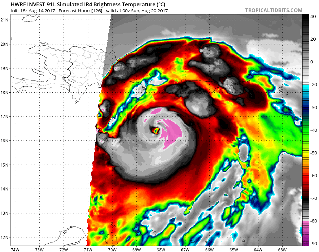


Ptarmigan wrote:I saw the HWFI have 91L as a Category 5 hurricane.
http://www.ral.ucar.edu/hurricanes/real ... _early.png
blp wrote:Ptarmigan wrote:I saw the HWFI have 91L as a Category 5 hurricane.
http://www.ral.ucar.edu/hurricanes/real ... _early.png
Yes it looks vicious.
https://uploads.disquscdn.com/images/04 ... 9410c2.png
Hurricaneman wrote:Ptarmigan wrote:I saw the HWFI have 91L as a Category 5 hurricane.
http://www.ral.ucar.edu/hurricanes/real ... _early.png
All the intensity models have a hurricane in 96 hrs but I feel that's too bullish
blp wrote:Ptarmigan wrote:I saw the HWFI have 91L as a Category 5 hurricane.
http://www.ral.ucar.edu/hurricanes/real ... _early.png
Yes it looks vicious.
Alyono wrote:blp wrote:Ptarmigan wrote:I saw the HWFI have 91L as a Category 5 hurricane.
http://www.ral.ucar.edu/hurricanes/real ... _early.png
Yes it looks vicious.
NOT VALID!!!
Too close to the lateral boundary
gatorcane wrote:Models have shifted south or either dropped this:
blp wrote:Ptarmigan wrote:I saw the HWFI have 91L as a Category 5 hurricane.
http://www.ral.ucar.edu/hurricanes/real ... _early.png
Yes it looks vicious.

SouthFLTropics wrote:Some fairly big changes on the 00z GFS. The Eastern wave is farther South this run and the Western wave is farther west...looks to be enough separation for two separate entities.
Users browsing this forum: No registered users and 48 guests


