ATL: HARVEY - Post-Tropical - Discussion
Moderator: S2k Moderators
-
chris_fit

- Category 5

- Posts: 3261
- Age: 43
- Joined: Wed Sep 10, 2003 11:58 pm
- Location: Tampa Bay Area, FL
Re: ATL: HARVEY - Hurricane - Discussion
Any news stations doing live streaming from the impacted area?
0 likes
-
tolakram
- Admin

- Posts: 20185
- Age: 62
- Joined: Sun Aug 27, 2006 8:23 pm
- Location: Florence, KY (name is Mark)
Re: ATL: HARVEY - Hurricane - Discussion
Thetxhurricanemaster wrote:Winds really picking up in corpus christi
Good luck. I would drive further inland if I were you, the winds plus surge plus rain of a stalled system is going to make travel near impossible.
1 likes
M a r k
- - - - -
Join us in chat: Storm2K Chatroom Invite. Android and IOS apps also available.
The posts in this forum are NOT official forecasts and should not be used as such. Posts are NOT endorsed by any professional institution or STORM2K.org. For official information and forecasts, please refer to NHC and NWS products.
-
ScottNAtlanta

- Category 5
- Posts: 2535
- Joined: Sat May 25, 2013 3:11 pm
- Location: Atlanta, GA
Re: ATL: HARVEY - Hurricane - Discussion
Reference material on ERC
https://en.wikipedia.org/wiki/Eyewall_replacement_cycle
Eyewall replacement cycles, also called concentric eyewall cycles, naturally occur in intense tropical cyclones, generally with winds greater than 185 km/h (115 mph), or major hurricanes (Category 3 or above). When tropical cyclones reach this intensity, and the eyewall contracts or is already sufficiently small, some of the outer rainbands may strengthen and organize into a ring of thunderstorms—an outer eyewall—that slowly moves inward and robs the inner eyewall of its needed moisture and angular momentum. Since the strongest winds are in a cyclone's eyewall, the tropical cyclone usually weakens during this phase, as the inner wall is "choked" by the outer wall. Eventually the outer eyewall replaces the inner one completely, and the storm may re-intensify.
The discovery of this process was partially responsible for the end of the U.S. government's hurricane modification experiment Project Stormfury. This project set out to seed clouds outside the eyewall, apparently causing a new eyewall to form and weakening the storm. When it was discovered that this was a natural process due to hurricane dynamics, the project was quickly abandoned.[1]
Almost every intense hurricane undergoes at least one of these cycles during its existence. Recent studies have shown that nearly half of all tropical cyclones, and nearly all cyclones with sustained winds over 204 kilometres per hour (127 mph; 110 kn), undergo eyewall replacement cycles.[2] Hurricane Allen in 1980 went through repeated eyewall replacement cycles, fluctuating between Category 5 and Category 3 status on the Saffir-Simpson Hurricane Scale several times. Hurricane Juliette (2001) was a rare documented case of triple eyewalls.[3] Typhoon June (1975) was the first reported case of triple eyewalls.[4]
0 likes
The posts in this forum are NOT official forecast and should not be used as such. They are just the opinion of the poster and may or may not be backed by sound meteorological data. They are NOT endorsed by any professional institution or storm2k.org. For official information, please refer to the NHC and NWS products.
-
Thetxhurricanemaster
- Category 1

- Posts: 279
- Age: 35
- Joined: Tue Aug 01, 2017 6:53 pm
- Location: Corpus christi
Re: ATL: HARVEY - Hurricane - Discussion
tolakram wrote:Thetxhurricanemaster wrote:Winds really picking up in corpus christi
Good luck. I would drive further inland if I were you, the winds plus surge plus rain of a stalled system is going to make travel near impossible.
Will the after math be bad ?
0 likes
-
JtSmarts

- S2K Supporter

- Posts: 1442
- Age: 40
- Joined: Thu Jul 10, 2003 1:29 pm
- Location: Columbia, South Carolina
Re: ATL: HARVEY - Hurricane - Discussion
chris_fit wrote:Any news stations doing live streaming from the impacted area?
http://www.kiiitv.com/news/live_breakin ... /280701833
http://www.kristv.com/category/292861/live-stream (Not on air at this moment)
2 likes
-
euro6208
Re: ATL: HARVEY - Hurricane - Discussion
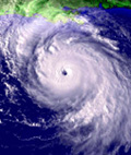
Been tracking this storm for learning experience. Leading dvorak and ADT by a bunch, dvorak is nothing. I wonder how much stronger the typhoons were. A hurricane near Cat 3 with no well developed eye on satellite is something. Now we can't judge a typhoon by it's looks...
Last edited by euro6208 on Fri Aug 25, 2017 7:55 am, edited 1 time in total.
1 likes
-
tolakram
- Admin
- Posts: 20185
- Age: 62
- Joined: Sun Aug 27, 2006 8:23 pm
- Location: Florence, KY (name is Mark)
Re: ATL: HARVEY - Hurricane - Discussion
Thetxhurricanemaster wrote:tolakram wrote:Thetxhurricanemaster wrote:Winds really picking up in corpus christi
Good luck. I would drive further inland if I were you, the winds plus surge plus rain of a stalled system is going to make travel near impossible.
Will the after math be bad ?
Last post about this. If you don't know then get out now. Yes, the aftermath will be bad with a nearly stalled major hurricane winding down near Corpus for days and days.
1 likes
M a r k
- - - - -
Join us in chat: Storm2K Chatroom Invite. Android and IOS apps also available.
The posts in this forum are NOT official forecasts and should not be used as such. Posts are NOT endorsed by any professional institution or STORM2K.org. For official information and forecasts, please refer to NHC and NWS products.
- - - - -
Join us in chat: Storm2K Chatroom Invite. Android and IOS apps also available.
The posts in this forum are NOT official forecasts and should not be used as such. Posts are NOT endorsed by any professional institution or STORM2K.org. For official information and forecasts, please refer to NHC and NWS products.
-
hd44
Re: ATL: HARVEY - Hurricane - Discussion
http://www.nhc.noaa.gov/audio/201708251205.mp3
Nhc audio update.
Nhc audio update.
0 likes

Re: ATL: HARVEY - Hurricane - Discussion
Thetxhurricanemaster wrote:tolakram wrote:Thetxhurricanemaster wrote:Winds really picking up in corpus christi
Good luck. I would drive further inland if I were you, the winds plus surge plus rain of a stalled system is going to make travel near impossible.
Will the after math be bad ?
If it continues to increase they could be devastating.
0 likes
Re: ATL: HARVEY - Hurricane - Discussion
Alyono wrote:SouthDadeFish wrote:Besides the storm surge threat along the coast, this graphic is what scares me the most:
It is hard to comprehend what 20+ inches of rain is like. Not only this, but to have 20+ inches of rain over such a large area is truly incredible. I am very afraid of the potential for significant inland flooding. Remember, water is what tends to kill people in tropical cyclones. Many people think it is okay to drive through roads in which they cannot see the bottom of the water. Do not do this. Turn around - don't drown!
what;s scaring me si the potential for 150 mph gusts in downtown Corpus. That's probably the most immediate concern. No mandatory evacuation was ordered for Corpus

Why would they not issue a 'Mandatory Evacuation'?
0 likes

Re: ATL: HARVEY - Hurricane - Discussion
Hurricane force winds must be confined to a small radius of the storm now as I can't find anything greater than 30-40 kts from offshore buoys. This was one of the highest located northeast of the center.
http://www.ndbc.noaa.gov/show_plot.php?station=kvaf&meas=wdpr&uom=E&time_diff=-5&time_label=CDT
http://www.ndbc.noaa.gov/show_plot.php?station=kvaf&meas=wdpr&uom=E&time_diff=-5&time_label=CDT
0 likes

Re: ATL: HARVEY - Hurricane - Discussion
Thetxhurricanemaster wrote:tolakram wrote:Thetxhurricanemaster wrote:Winds really picking up in corpus christi
Good luck. I would drive further inland if I were you, the winds plus surge plus rain of a stalled system is going to make travel near impossible.
Will the after math be bad ?
why in God's name are you still there?
6 likes
Re: ATL: HARVEY - Hurricane - Discussion
Those in Corpus Christi and Victoria, you have a potential for 110 + mph winds.
See this link with graphic
http://www.weather.gov/srh/tropical?office=crp#hti
See this link with graphic
http://www.weather.gov/srh/tropical?office=crp#hti
Last edited by artist on Fri Aug 25, 2017 8:08 am, edited 1 time in total.
0 likes

Re: ATL: HARVEY - Hurricane - Discussion
euro6208 wrote:Been tracking this storm for learning experience. Leading dvorak and ADT by a bunch, dvorak is nothing. I wonder how much stronger the typhoons were. A hurricane near Cat 3 with no well developed eye on satellite is something. Now we can't judge a typhoon by it's looks...
Feel free to come up with a better way to estimate typhoons by satellite. In 40 years, no one has been able to improve on Dvorak. The statistics show it does surprisingly well all things considered.
1 likes

Re: ATL: HARVEY - Hurricane - Discussion
It has really slowed downed the last couple of hours.

0 likes
Re: ATL: HARVEY - Hurricane - Discussion
artist wrote:Those in Corpus Christi and Victoria, you have a potential for 110 mph winds.
See this link with graphic
http://www.weather.gov/srh/tropical?office=crp#hti
Victoria itself likely won't see 100 mph gusts. In fact, the gusts likely will be less than Claudette because this is moving much slower than Claudette. It will weaken.
But Corpus, this could be Celia
0 likes
-
Hurricane Andrew

- S2K Supporter
- Posts: 1891
- Age: 27
- Joined: Sun May 23, 2010 2:53 pm
- Location: KS
Re: ATL: HARVEY - Hurricane - Discussion
Corpus Christi's P&C forecast has hurricane conditions possible through sunday night....wow.
https://forecast.weather.gov/MapClick.p ... aAfma_3arU
https://forecast.weather.gov/MapClick.p ... aAfma_3arU
0 likes
The Enthusiast
NREMT-AEMT, WX nerd
Irene '11, Sandy '12, Irma '17 (SAR)
"Hard to think we were born to live this way..." -Wage War
-
SouthFLTropics

- Category 5
- Posts: 4258
- Age: 50
- Joined: Thu Aug 14, 2003 8:04 am
- Location: Port St. Lucie, Florida
Re: ATL: HARVEY - Hurricane - Discussion
I've seen some posts on this thread talking about whether or not the aftermath will be bad. In a word, YES. In my experience with all of the storms I've been through the aftermath is just as bad, if not worse, than the storm itself. Days or weeks with no power, contaminated water with possible spreading disease, massive areas of devastation, and a severe shortage of basic needs. I fear that this storm will be worse than what many of us have ever experienced due to the duration of the event. Don't wait...if you're in an evacuation zone or have any doubt of your ability to sustain yourself after the storm, the time to leave is NOW!!!
4 likes
Fourth Generation Florida Native
Personal Storm History: David 79, Andrew 92, Erin 95, Floyd 99, Irene 99, Frances 04, Jeanne 04, Wilma 05, Matthew 16, Irma 17, Ian 22, Nicole 22, Milton 24
Personal Storm History: David 79, Andrew 92, Erin 95, Floyd 99, Irene 99, Frances 04, Jeanne 04, Wilma 05, Matthew 16, Irma 17, Ian 22, Nicole 22, Milton 24
-
Slughitter3
- Tropical Depression

- Posts: 54
- Age: 36
- Joined: Wed Jul 10, 2013 1:16 pm
- Location: Huntingtown, MD
Re: ATL: HARVEY - Hurricane - Discussion
JtSmarts wrote:chris_fit wrote:Any news stations doing live streaming from the impacted area?
http://www.kiiitv.com/news/live_breakin ... /280701833
http://www.kristv.com/category/292861/live-stream (Not on air at this moment)
periscope.tv and then just search for Harvey, enjoy all the people that are hanging out to stream the storm.
1 likes
I'm a weather-loving Coastie.
This post is only an opinion not a forecast. Please refer to the NHC and local NWS offices for forecasts.
Shawn
This post is only an opinion not a forecast. Please refer to the NHC and local NWS offices for forecasts.
Shawn
-
forecasterjack
- Tropical Storm

- Posts: 195
- Joined: Wed Aug 23, 2017 3:44 pm
Re: ATL: HARVEY - Hurricane - Discussion
Sunrise over the storm is stunning. You can see everything we've been talking about here: eye wall changes, new hot towers, a hint of mid level dry air, expansive outflow. This thing is wild. Praying for Texas https://weather.us/satellite/921-w-267- ... .html#play
0 likes
Who is online
Users browsing this forum: No registered users and 62 guests