ATL: HARVEY - Post-Tropical - Discussion

Moderator: S2k Moderators

Message
Author
CryHavoc
Tropical Storm
Tropical Storm
Posts: 201
Age: 43
Joined: Thu Aug 24, 2017 5:18 pm
Location: Bay Area CA

Re: ATL: HARVEY - Hurricane - Discussion

#3701 Postby CryHavoc » Fri Aug 25, 2017 12:16 pm

Langinbang187 wrote:I really thought he'd be pushing cat 4 at this point if I'm being honest. Kind of surprised.

& Yes, 839 was indeed a typo. :lol:


839 would be some "The Day After Tomorrow" type stuff. Haha.
1 likes   

User avatar
tarheelprogrammer
S2K Supporter
S2K Supporter
Posts: 1793
Joined: Mon Mar 28, 2016 9:25 pm
Location: Raleigh, NC area (Garner, NC)

Re: ATL: HARVEY - Hurricane - Discussion

#3702 Postby tarheelprogrammer » Fri Aug 25, 2017 12:16 pm

Yellow Evan wrote:
Aric Dunn wrote:
Yellow Evan wrote:88 SFMR doesn't yet justify going to Cat 3.


blend of flight and SFMR does from this plane and last plane.


90% of 107 is 96 knots. 96+88/2=92 knots.


Which would mean it has weakened some, correct?
0 likes   
My posts are not official forecasts. They are just my opinion and may or may not be backed by sound meteorological data. They are NOT endorsed by any professional institution or storm2k.org. For official information, please refer to the NHC and NWS products.

User avatar
Yellow Evan
Professional-Met
Professional-Met
Posts: 16172
Age: 27
Joined: Fri Jul 15, 2011 12:48 pm
Location: Henderson, Nevada/Honolulu, HI
Contact:

Re: ATL: HARVEY - Hurricane - Discussion

#3703 Postby Yellow Evan » Fri Aug 25, 2017 12:18 pm

tarheelprogrammer wrote:
Yellow Evan wrote:
90% of 107 is 96 knots. 96+88/2=92 knots.


Which would mean it has weakened some, correct?


Perhaps, but given the unsolvable problem of undersampling, I'd think twice before lowering the winds.
1 likes   

MaineWeatherNut
Tropical Storm
Tropical Storm
Posts: 225
Joined: Sun Sep 01, 2013 5:06 pm

Re: ATL: HARVEY - Hurricane - Discussion

#3704 Postby MaineWeatherNut » Fri Aug 25, 2017 12:18 pm

tarheelprogrammer wrote:
Yellow Evan wrote:
Aric Dunn wrote:
blend of flight and SFMR does from this plane and last plane.


90% of 107 is 96 knots. 96+88/2=92 knots.


Which would mean it has weakened some, correct?


No it hasn't weakened at all. In fact pressure continues to fall.
0 likes   
The content of this post does NOT constitute official forecast and should not be used as such. They are the opinion of the poster and may or may not be backed by sound meteorological data. They are NOT endorsed by any professional institution or Storm2K. For official information, please refer to the local meteorological centers of respective areas.

User avatar
WxGuy1
Professional-Met
Professional-Met
Posts: 538
Joined: Sat Oct 22, 2005 12:55 pm
Location: Oklahoma

Re: ATL: HARVEY - Hurricane - Discussion

#3705 Postby WxGuy1 » Fri Aug 25, 2017 12:18 pm

Yellow Evan wrote:88 SFMR doesn't yet justify going to Cat 3.
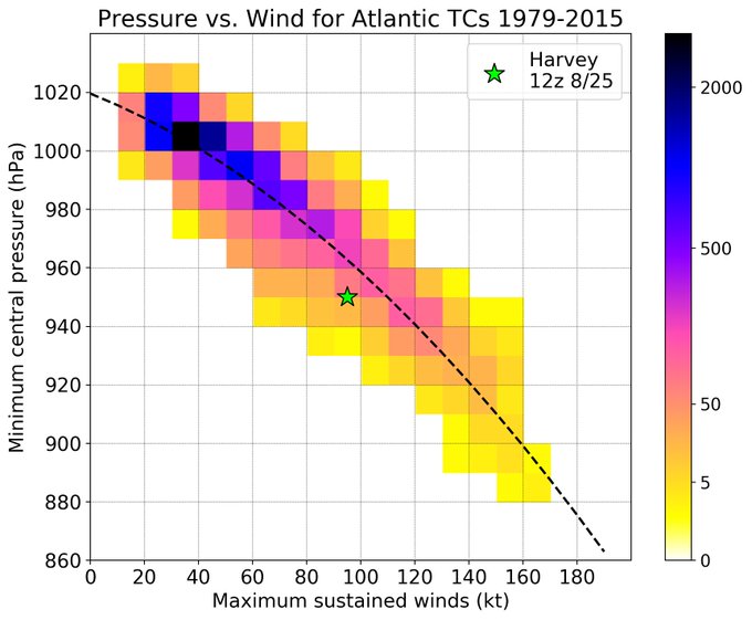

88 kts (101 mph) is solidly in Cat 2 (83-95 kts). The NE part probably is a little stronger than the N part, but recon data indicate Harvey is still a cat 2 hurricane. The min central pressure is getting pretty low for "only" ~88 kt max winds, but there's quite a bit of variability in terms of the pressure-wind relation in hurricanes. See this nice plot by @splillo on Twitter (note that pressure has fallen, so shift the start down about one grid box)... Hurricanes with similar minimum central pressures have had winds anywhere from Cat 1 to Cat 5 :
Image

Harvey is smaller (at least in terms of area of >64 kt winds) than Ike was. It still seems that the main impact from Harvey for most people will be the widespread flooding that will occur.
Last edited by WxGuy1 on Fri Aug 25, 2017 12:19 pm, edited 1 time in total.
2 likes   

Aric Dunn
Category 5
Category 5
Posts: 21238
Age: 42
Joined: Sun Sep 19, 2004 9:58 pm
Location: Ready for the Chase.
Contact:

Re: ATL: HARVEY - Hurricane - Discussion

#3706 Postby Aric Dunn » Fri Aug 25, 2017 12:19 pm

Yellow Evan wrote:
Aric Dunn wrote:
Yellow Evan wrote:88 SFMR doesn't yet justify going to Cat 3.


blend of flight and SFMR does from this plane and last plane.


90% of 107 is 96 knots. 96+88/2=92 knots.


and the previous plane last pass was 115kt FL. NE quad. this pass currently was not right front..
0 likes   
Note: If I make a post that is brief. Please refer back to previous posts for the analysis or reasoning. I do not re-write/qoute what my initial post said each time.
If there is nothing before... then just ask :)

Space & Atmospheric Physicist, Embry-Riddle Aeronautical University,
I believe the sky is falling...

User avatar
Hammy
Category 5
Category 5
Posts: 5850
Age: 42
Joined: Fri May 25, 2012 5:25 pm
Contact:

Re: ATL: HARVEY - Hurricane - Discussion

#3707 Postby Hammy » Fri Aug 25, 2017 12:20 pm

Given the surface winds seem lower this pass than earlier I don't think Harvey will make Cat 2. In fact the models yesterday seemed to indicate some weakening in the 12 hours or so before landfall so that's likely begun now.
3 likes   
The above post is not official and should not be used as such. It is the opinion of the poster and may or may not be backed by sound meteorological data. It is not endorsed by any professional institution or storm2k.org. For official information, please refer to the NHC and NWS products.

J_J99
Tropical Depression
Tropical Depression
Posts: 68
Age: 25
Joined: Wed Mar 09, 2016 9:43 pm
Location: Cincinnati, OH

Re: ATL: HARVEY - Hurricane - Discussion

#3708 Postby J_J99 » Fri Aug 25, 2017 12:23 pm

Hammy wrote:Given the surface winds seem lower this pass than earlier I don't think Harvey will make Cat 2. In fact the models yesterday seemed to indicate some weakening in the 12 hours or so before landfall so that's likely begun now.

I fully disagree.... its lower compared to last time because they are in the NW Quadrant NOT the NE Quadrant..... I am very interested in seeing the NE Qudrant winds.

NW Quadrant winds already make a case for Cat 3 without SFMR with 90% of 107 kts flight level wind.....

But I think NE Quadrant will confirm we most likely (in my opinion) have a Cat 3
1 likes   
The following post is NOT an official forecast and should not be used as such. It is just the opinion of the poster and may or may not be backed by sound meteorological data. It is NOT endorsed by any professional institution including storm2k.org For Official Information please refer to the NHC and NWS products.

stephen23
Category 1
Category 1
Posts: 341
Joined: Sat Aug 04, 2012 10:57 pm
Location: North Fort Worth

Re: ATL: HARVEY - Hurricane - Discussion

#3709 Postby stephen23 » Fri Aug 25, 2017 12:23 pm

Hammy wrote:Given the surface winds seem lower this pass than earlier I don't think Harvey will make Cat 2. In fact the models yesterday seemed to indicate some weakening in the 12 hours or so before landfall so that's likely begun now.

Has been a Cat 2 since yesterday
2 likes   
Personal Forecast Disclaimer:
The posts in this forum are NOT official forecast and should not be used as such. They are just the opinion of the poster and may or may not be backed by sound meteorological data. They are NOT endorsed by any professional institution or storm2k.org. For official information, please refer to the NHC and NWS products.

MaineWeatherNut
Tropical Storm
Tropical Storm
Posts: 225
Joined: Sun Sep 01, 2013 5:06 pm

Re: ATL: HARVEY - Hurricane - Discussion

#3710 Postby MaineWeatherNut » Fri Aug 25, 2017 12:24 pm

Hammy wrote:Given the surface winds seem lower this pass than earlier I don't think Harvey will make Cat 2. In fact the models yesterday seemed to indicate some weakening in the 12 hours or so before landfall so that's likely begun now.


You mean Cat 3? The fact the Pressure continues to fall doesn't seem to indicate that's weakening at all. The NorthEast Quad is the strongest which hasn't been sampled yet this mission.
0 likes   
The content of this post does NOT constitute official forecast and should not be used as such. They are the opinion of the poster and may or may not be backed by sound meteorological data. They are NOT endorsed by any professional institution or Storm2K. For official information, please refer to the local meteorological centers of respective areas.

User avatar
NDG
S2K Supporter
S2K Supporter
Posts: 15469
Joined: Sun Jul 09, 2006 10:14 pm
Location: Orlando, FL

Re: ATL: HARVEY - Hurricane - Discussion

#3711 Postby NDG » Fri Aug 25, 2017 12:24 pm

Zoomed in satellite loop.

Image
2 likes   

Sanibel
Category 5
Category 5
Posts: 10375
Joined: Mon Aug 30, 2004 11:06 pm
Location: Offshore SW Florida

Re: ATL: HARVEY - Hurricane - Discussion

#3712 Postby Sanibel » Fri Aug 25, 2017 12:24 pm

I think the current sharpening and slight contraction of that outer eye might indicate one last 5 to 10mph push but I might be wrong...


The posts in this forum are NOT official forecast and should not be used as such. They are just the opinion of the poster and may or may not be backed by sound meteorological data. They are NOT endorsed by any professional institution or STORM2K. For official information, please refer to products from the National Hurricane Center and National Weather Service.
2 likes   

CrazyC83
Professional-Met
Professional-Met
Posts: 34093
Joined: Tue Mar 07, 2006 11:57 pm
Location: Deep South, for the first time!

Re: ATL: HARVEY - Hurricane - Discussion

#3713 Postby CrazyC83 » Fri Aug 25, 2017 12:24 pm

All indications are that 95 kt remains reasonable for the intensity. The SFMR tends to be +/- 5 kt per pass, and the FL winds solidly support such. Nothing supports a major yet though.
1 likes   

RL3AO
Moderator-Pro Met
Moderator-Pro Met
Posts: 16308
Joined: Thu Jun 14, 2007 10:03 pm
Location: NC

Re: ATL: HARVEY - Hurricane - Discussion

#3714 Postby RL3AO » Fri Aug 25, 2017 12:25 pm

At this rate I hope it is a cat 2 at landfall. If two of the costliest storms on record are "only cat 2s" at landfall, maybe people will stop with this absurd fascination of "major hurricanes".
8 likes   

User avatar
gfsperpendicular
Category 1
Category 1
Posts: 383
Age: 21
Joined: Mon Jun 19, 2017 3:04 pm
Location: Northern Virginia

Re: ATL: HARVEY - Hurricane - Discussion

#3715 Postby gfsperpendicular » Fri Aug 25, 2017 12:26 pm

NDG wrote:Zoomed in satellite loop.


Inner eyewall really refiring in the last frame there.
0 likes   
I'm not sleeping, I'm waiting for the 0900 UTC advisory!

#1 CMC stan

CycloneGuru

Re: ATL: HARVEY - Hurricane - Discussion

#3716 Postby CycloneGuru » Fri Aug 25, 2017 12:28 pm

what kind of widespread flooding are we talking here exaclty? Im sure us smart people could invent or come up with some sort of 3D program that can take in any affect of the topography, climate and other things, along with the storm and its current data, and be able to show exaclty and where and when the flooding occurs.... am I on to something or nahhhhh?
2 likes   

User avatar
gatorcane
S2K Supporter
S2K Supporter
Posts: 23693
Age: 47
Joined: Sun Mar 13, 2005 3:54 pm
Location: Boca Raton, FL

Re: ATL: HARVEY - Hurricane - Discussion

#3717 Postby gatorcane » Fri Aug 25, 2017 12:28 pm

IR loop of Harvey does show some slight cloud top warming but overall this is one formidable hurricane. :eek:

Image
0 likes   

User avatar
PaulR
Tropical Depression
Tropical Depression
Posts: 70
Joined: Mon Dec 03, 2012 2:43 pm
Location: Mid-South USA

Re: ATL: HARVEY - Hurricane - Discussion

#3718 Postby PaulR » Fri Aug 25, 2017 12:29 pm

Blinhart wrote:All they are talking about is Surge damage, they aren't talking about the real damage will be from the waves on top of that Surge. If this storm actually does have waves almost 40 feet tall you talking damage 4 stories higher above the surge.


Hi, All,

It's been a while since I've posted; I usually come here when a relative is in the area of a serious storm, or, a storm piques my interest for whatever reason. Even then I often do not post, as often I have little to add, unless I have a question. :)

In this case:

I may be wrong about this, but would not the wave height be from trough to crest (peak), with the "crest height" being the height above the "still water line" (which in this case the STL would be the surge level/height?)?

OTOH, if the waves in the open ocean are 40' from crest to trough, what kind of breakers can that generate?
0 likes   
"Normal" is Chicago under a mile of ice.

Aric Dunn
Category 5
Category 5
Posts: 21238
Age: 42
Joined: Sun Sep 19, 2004 9:58 pm
Location: Ready for the Chase.
Contact:

Re: ATL: HARVEY - Hurricane - Discussion

#3719 Postby Aric Dunn » Fri Aug 25, 2017 12:29 pm

Radar showing inner eyewall might finally have stopped producing deep convection. the new eyewall is becoming much more intense the last 15 minutes could be a sign of deepening as long as the inner remnants are fully cut off..
1 likes   
Note: If I make a post that is brief. Please refer back to previous posts for the analysis or reasoning. I do not re-write/qoute what my initial post said each time.
If there is nothing before... then just ask :)

Space & Atmospheric Physicist, Embry-Riddle Aeronautical University,
I believe the sky is falling...

User avatar
Extratropical94
Professional-Met
Professional-Met
Posts: 3538
Age: 30
Joined: Wed Oct 20, 2010 6:36 am
Location: Hamburg, Germany
Contact:

Re: ATL: HARVEY: Observations,Web Cams, Local NWS Statements Texas / Louisiana

#3720 Postby Extratropical94 » Fri Aug 25, 2017 12:29 pm

Conditions are deteriorating quickly as far north as Bolivar Peninsula.

https://www.bolivarpeninsulatexas.com/W ... rise-Beach
1 likes   
54° 11' 59'' N, 9° 9' 20'' E
Boomer Sooner!
Go Broncos! Go Cards! Go Niners!
- Daniel


Return to “2017”

Who is online

Users browsing this forum: No registered users and 3 guests