ATL: HARVEY - Post-Tropical - Discussion
Moderator: S2k Moderators
-
SunnyThoughts
- Category 5

- Posts: 2263
- Joined: Wed Jul 09, 2003 12:42 pm
- Location: Pensacola, Florida
Re: ATL: HARVEY - Tropical Storm - Discussion
CBS news has broken in and showing rescues ongoing for those interested.
0 likes
-
tolakram
- Admin

- Posts: 20181
- Age: 62
- Joined: Sun Aug 27, 2006 8:23 pm
- Location: Florence, KY (name is Mark)
Re: ATL: HARVEY - Tropical Storm - Discussion
KHOU off the air, transmitter flooded. Their youtube stream is showing CBS for those interested. Search KHOU Houston in Youtube.
2 likes
M a r k
- - - - -
Join us in chat: Storm2K Chatroom Invite. Android and IOS apps also available.
The posts in this forum are NOT official forecasts and should not be used as such. Posts are NOT endorsed by any professional institution or STORM2K.org. For official information and forecasts, please refer to NHC and NWS products.
-
ConvergenceZone
.gif)
- Category 5
- Posts: 5241
- Joined: Fri Jul 29, 2005 1:40 am
- Location: Northern California
Re: ATL: HARVEY - Tropical Storm - Discussion
They were saying on TV that even if the main strong bands of rain remain East of Houston, they can still get another 3 to 5 inches of rain on top of already saturated ground
0 likes
-
Aric Dunn
- Category 5
- Posts: 21238
- Age: 43
- Joined: Sun Sep 19, 2004 9:58 pm
- Location: Ready for the Chase.
- Contact:
Re: ATL: HARVEY - Tropical Storm - Discussion
THe center is getting close enough to start tapping into the warm waters... if we start seeing convection building closer to the center watch out..
2 likes
Note: If I make a post that is brief. Please refer back to previous posts for the analysis or reasoning. I do not re-write/qoute what my initial post said each time.
If there is nothing before... then just ask
Space & Atmospheric Physicist, Embry-Riddle Aeronautical University,
I believe the sky is falling...
If there is nothing before... then just ask
Space & Atmospheric Physicist, Embry-Riddle Aeronautical University,
I believe the sky is falling...
-
tarheelprogrammer

- S2K Supporter

- Posts: 1793
- Joined: Mon Mar 28, 2016 9:25 pm
- Location: Raleigh, NC area (Garner, NC)
Re: ATL: HARVEY - Tropical Storm - Discussion
Could this strengthen back to a hurricane?
0 likes
My posts are not official forecasts. They are just my opinion and may or may not be backed by sound meteorological data. They are NOT endorsed by any professional institution or storm2k.org. For official information, please refer to the NHC and NWS products.
-
jaguars_22
- Category 2

- Posts: 629
- Joined: Tue Jun 20, 2017 2:26 pm
- Location: Victoria TX
Re: ATL: HARVEY - Tropical Storm - Discussion
What's forecast looking like for us in victoria
0 likes
-
AdamFirst

- S2K Supporter
- Posts: 2490
- Age: 36
- Joined: Thu Aug 14, 2008 10:54 am
- Location: Port Saint Lucie, FL
Re: ATL: HARVEY - Tropical Storm - Discussion
If the EURO forecast verifies, it could. But at this point we all should be hoping it doesn't.tarheelprogrammer wrote:Could this strengthen back to a hurricane?
1 likes
Dolphins Marlins Canes Golden Panthers HEAT
Andrew 1992 - Irene 1999 - Frances 2004 - Jeanne 2004 - Wilma 2005 - Fay 2008 - Isaac 2012 - Matthew 2016 - Irma 2017 - Dorian 2019 - Ian 2022 - Nicole 2022 - Milton 2024
Andrew 1992 - Irene 1999 - Frances 2004 - Jeanne 2004 - Wilma 2005 - Fay 2008 - Isaac 2012 - Matthew 2016 - Irma 2017 - Dorian 2019 - Ian 2022 - Nicole 2022 - Milton 2024

Re: ATL: HARVEY - Tropical Storm - Discussion
Nolachick504 wrote:Hi guys! We are experiencing a bad thunderstorm and strong winds here in New Orleans. Is this from Harvey? We were not suppose to see effects from it til Wednesday. Btw Im new here. Thanks!
Welcome.
Here is what your nws has, and according to radar, it appears it is a band from Harvey.
-
Looking ahead, there still remains a chance for narrow bands of
tropical showers and thunderstorms to develop at times between
today and Thursday before Harvey finally lifts out of the region
later this week. Rainfall accumulations generally between 2 and 5
inches is now indicated over the next 5 days, with the lower end
likely over the Mississippi coastal counties, the higher end of
the range over east-central and south-central Louisiana, closer to
the influences of Harvey.
http://forecast.weather.gov/showsigwx.p ... n=-90.0778
Last edited by artist on Sun Aug 27, 2017 11:40 am, edited 1 time in total.
1 likes
-
Hurricane Andrew

- S2K Supporter
- Posts: 1891
- Age: 27
- Joined: Sun May 23, 2010 2:53 pm
- Location: KS
Re: ATL: HARVEY - Tropical Storm - Discussion
Houston is now under a Tornado Warning...I wish I had a way to go down and help with ongoing rescues. I'd be more than willing to volunteer my time and training.
Code: Select all
* Tornado Warning for...
  North central Brazoria County in southeastern Texas...
  South central Harris County in southeastern Texas...

* Until 1145 AM CDT.

* At 1120 AM CDT, a severe thunderstorm capable of producing a
  tornado was located over Brookside Village, or near Pearland,
  moving north at 35 mph.

  HAZARD...Tornado.

  SOURCE...Radar indicated rotation.

  IMPACT...Flying debris will be dangerous to those caught without
           shelter. Mobile homes will be damaged or destroyed.
           Damage to roofs, windows, and vehicles will occur.  Tree
           damage is likely.
2 likes
The Enthusiast
NREMT-AEMT, WX nerd
Irene '11, Sandy '12, Irma '17 (SAR)
"Hard to think we were born to live this way..." -Wage War
-
tolakram
- Admin
- Posts: 20181
- Age: 62
- Joined: Sun Aug 27, 2006 8:23 pm
- Location: Florence, KY (name is Mark)
Re: ATL: HARVEY - Tropical Storm - Discussion
tarheelprogrammer wrote:Could this strengthen back to a hurricane?
I'm not sure there's a good answer. A few forecasters think yes, the Euro hints at it, but generally once over land it takes time for a storm to build back to hurricane strength. In my opinion the number one concern is not wind speed but if Harvey can re consolidate enough to bring even more moisture on shore. Most models except GFS have offshore and then back onshore near Houston. NHC shows this as well but keeps Harvey as a tropical storm.

2 likes
M a r k
- - - - -
Join us in chat: Storm2K Chatroom Invite. Android and IOS apps also available.
The posts in this forum are NOT official forecasts and should not be used as such. Posts are NOT endorsed by any professional institution or STORM2K.org. For official information and forecasts, please refer to NHC and NWS products.
- - - - -
Join us in chat: Storm2K Chatroom Invite. Android and IOS apps also available.
The posts in this forum are NOT official forecasts and should not be used as such. Posts are NOT endorsed by any professional institution or STORM2K.org. For official information and forecasts, please refer to NHC and NWS products.

Re: ATL: HARVEY - Tropical Storm - Discussion
For those who were watching KHOU and lost the signal, KTRK is also live.
http://abc13.com/live/23374/
They have very good coverage and lots of live teams on the ground.
http://abc13.com/live/23374/
They have very good coverage and lots of live teams on the ground.
0 likes
-
tarheelprogrammer
- S2K Supporter
- Posts: 1793
- Joined: Mon Mar 28, 2016 9:25 pm
- Location: Raleigh, NC area (Garner, NC)
Re: ATL: HARVEY - Tropical Storm - Discussion
tolakram wrote:tarheelprogrammer wrote:Could this strengthen back to a hurricane?
I'm not sure there's a good answer. A few forecasters think yes, the Euro hints at it, but generally once over land it takes time for a storm to build back to hurricane strength. In my opinion the number one concern is not wind speed but if Harvey can re consolidate enough to bring even more moisture on shore. Most models except GFS have offshore and then back onshore near Houston. NHC shows this as well but keeps Harvey as a tropical storm.
I am worried about surge in Houston
0 likes
My posts are not official forecasts. They are just my opinion and may or may not be backed by sound meteorological data. They are NOT endorsed by any professional institution or storm2k.org. For official information, please refer to the NHC and NWS products.
-
tolakram
- Admin
- Posts: 20181
- Age: 62
- Joined: Sun Aug 27, 2006 8:23 pm
- Location: Florence, KY (name is Mark)
Re: ATL: HARVEY - Tropical Storm - Discussion
https://twitter.com/DrShepherd2013/status/901845821381124097
Marshall Shepherd ✔ @DrShepherd2013
People disproportionately die in cars from floods, so evacuation is not as straightforward a call as seems.
12:36 PM - Aug 27, 2017

Marshall Shepherd ✔ @DrShepherd2013
People disproportionately die in cars from floods, so evacuation is not as straightforward a call as seems.
12:36 PM - Aug 27, 2017
1 likes
M a r k
- - - - -
Join us in chat: Storm2K Chatroom Invite. Android and IOS apps also available.
The posts in this forum are NOT official forecasts and should not be used as such. Posts are NOT endorsed by any professional institution or STORM2K.org. For official information and forecasts, please refer to NHC and NWS products.
- - - - -
Join us in chat: Storm2K Chatroom Invite. Android and IOS apps also available.
The posts in this forum are NOT official forecasts and should not be used as such. Posts are NOT endorsed by any professional institution or STORM2K.org. For official information and forecasts, please refer to NHC and NWS products.
Re: ATL: HARVEY - Tropical Storm - Discussion
jaguars_22 wrote:What's forecast looking like for us in victoria
Here are all of the alerts for Victoria
Hurricane Local Statement
Flash Flood Watch until August 30, 07:00 PM CDT
Flood Warning
Tropical Storm Warning
Hazardous Weather Outlook
http://forecast.weather.gov/MapClick.ph ... n=-97.0036
Click the link to find details for each.
0 likes
-
tolakram
- Admin
- Posts: 20181
- Age: 62
- Joined: Sun Aug 27, 2006 8:23 pm
- Location: Florence, KY (name is Mark)
Re: ATL: HARVEY - Tropical Storm - Discussion
ZCZC MIATCDAT4 ALL
TTAA00 KNHC DDHHMM
Tropical Storm Harvey Discussion Number 29
NWS National Hurricane Center Miami FL AL092017
1000 AM CDT Sun Aug 27 2017
Harvey continues to meander over southeastern Texas, where it
is producing catastrophic and life-threatening flooding rainfall.
NWS radars show that bands of deep convection continue to develop
over the northwestern Gulf of Mexico and train over portions of
southeastern Texas, including the Houston/Galveston metropolitan
area. Rainfall amounts greater than 20-25 inches have already been
reported and flash flood emergencies and warnings have been issued
by local National Weather Service offices for a large portion of
southeastern Texas. Additional rainfall amounts of 15 to 25 inches
are expected over the next several days, and the NOAA Weather
Prediction Center is now forecasting isolated storm total amounts of
50 inches. These historic rainfall amounts will exacerbate the
already dire and life-threatening situation.
Surface observations of winds 30-35 kt within a band of convection
over the western Gulf of Mexico and along the coast of Texas support
an initial intensity of 35 kt. The latest track guidance show
Harvey moving slowly southeastward for the next 24 to 36 hours and
the center is likely to move very close to the coast, or even
offshore, between 24-48 hours. After that time, Harvey is expected
to begin a northward motion which should take it inland over eastern
Texas later in the period. Since a large portion of the circulation
is expected to remain over water during the next several days,
Harvey is maintained as a tropical storm through 72 hours. However,
the strongest winds are likely to occur over the Gulf waters.
Key Messages:
1. Ongoing catastrophic and life-threatening flooding will continue
across southeastern Texas. Additional rainfall accumulations of 15
to 25 inches are expected, with isolated storm totals as high as 50
inches, through Friday. Please heed the advice of local officials.
Do not attempt to travel if you are in a safe place, and do not
drive into flooded roadways. Refer to products from your local
National Weather Service office and the NOAA Weather Prediction
Center for more information on the flooding hazard. A summary of
rainfall totals compiled by the Weather Prediction Center can be
found at: www.wpc.ncep.noaa.gov/discussions/nfdscc1.html
FORECAST POSITIONS AND MAX WINDS
INIT 27/1500Z 29.0N 97.4W 35 KT 40 MPH
12H 28/0000Z 28.6N 97.3W 35 KT 40 MPH...INLAND
24H 28/1200Z 28.4N 96.8W 35 KT 40 MPH...INLAND
36H 29/0000Z 28.2N 96.3W 35 KT 40 MPH...OVER WATER
48H 29/1200Z 28.2N 96.0W 35 KT 40 MPH...OVER WATER
72H 30/1200Z 29.3N 95.7W 35 KT 40 MPH...INLAND
96H 31/1200Z 30.9N 95.5W 30 KT 35 MPH...INLAND
120H 01/1200Z 32.2N 95.1W 25 KT 30 MPH...INLAND
$$
Forecaster Brown
NNNN
0 likes
M a r k
- - - - -
Join us in chat: Storm2K Chatroom Invite. Android and IOS apps also available.
The posts in this forum are NOT official forecasts and should not be used as such. Posts are NOT endorsed by any professional institution or STORM2K.org. For official information and forecasts, please refer to NHC and NWS products.
- - - - -
Join us in chat: Storm2K Chatroom Invite. Android and IOS apps also available.
The posts in this forum are NOT official forecasts and should not be used as such. Posts are NOT endorsed by any professional institution or STORM2K.org. For official information and forecasts, please refer to NHC and NWS products.
-
Hurricane Andrew
- S2K Supporter
- Posts: 1891
- Age: 27
- Joined: Sun May 23, 2010 2:53 pm
- Location: KS
Re: ATL: HARVEY - Tropical Storm - Discussion
tolakram wrote: https://twitter.com/DrShepherd2013/status/901845821381124097
Marshall Shepherd ✔ @DrShepherd2013
People disproportionately die in cars from floods, so evacuation is not as straightforward a call as seems.
12:36 PM - Aug 27, 2017
Cannot be stressed enough at this point, if driving is not ABSOLUTELY NECESSARY, then STAY OFF THE ROADS. Water can rise feet in seconds in situations like this. You might be driving on a dry road that very quickly becomes not dry. FD/Rescue resources are MASSIVELY overstretched. They are going to be calling in mutual aid from around the nation for days. Hundreds of Bfs from LA and NY (per twitter) are already en route. This is an unreal situation. For those in the hot zone, BE SAFE. Check in on this forum so we know you are safe. Take precautions. Let someone know if you need help, only call 911 in a life-threatening emergency. BE SAFE.
0 likes
The Enthusiast
NREMT-AEMT, WX nerd
Irene '11, Sandy '12, Irma '17 (SAR)
"Hard to think we were born to live this way..." -Wage War
-
PTrackerLA

- Category 5
- Posts: 5281
- Age: 42
- Joined: Thu Oct 10, 2002 8:40 pm
- Location: Lafayette, LA
Re: ATL: HARVEY - Tropical Storm - Discussion
This is just heart breaking. I've contacted several friends in Houston area and thankfully their homes are dry for now. There's really no end in sight for days I can't believe what we are seeing.
0 likes
-
tolakram
- Admin
- Posts: 20181
- Age: 62
- Joined: Sun Aug 27, 2006 8:23 pm
- Location: Florence, KY (name is Mark)
Re: ATL: HARVEY - Tropical Storm - Discussion
Anyone from Beaumont or east that can check in. Houston is getting the coverage but rain has been pounding areas east of Houston all morning.
3 likes
M a r k
- - - - -
Join us in chat: Storm2K Chatroom Invite. Android and IOS apps also available.
The posts in this forum are NOT official forecasts and should not be used as such. Posts are NOT endorsed by any professional institution or STORM2K.org. For official information and forecasts, please refer to NHC and NWS products.
- - - - -
Join us in chat: Storm2K Chatroom Invite. Android and IOS apps also available.
The posts in this forum are NOT official forecasts and should not be used as such. Posts are NOT endorsed by any professional institution or STORM2K.org. For official information and forecasts, please refer to NHC and NWS products.
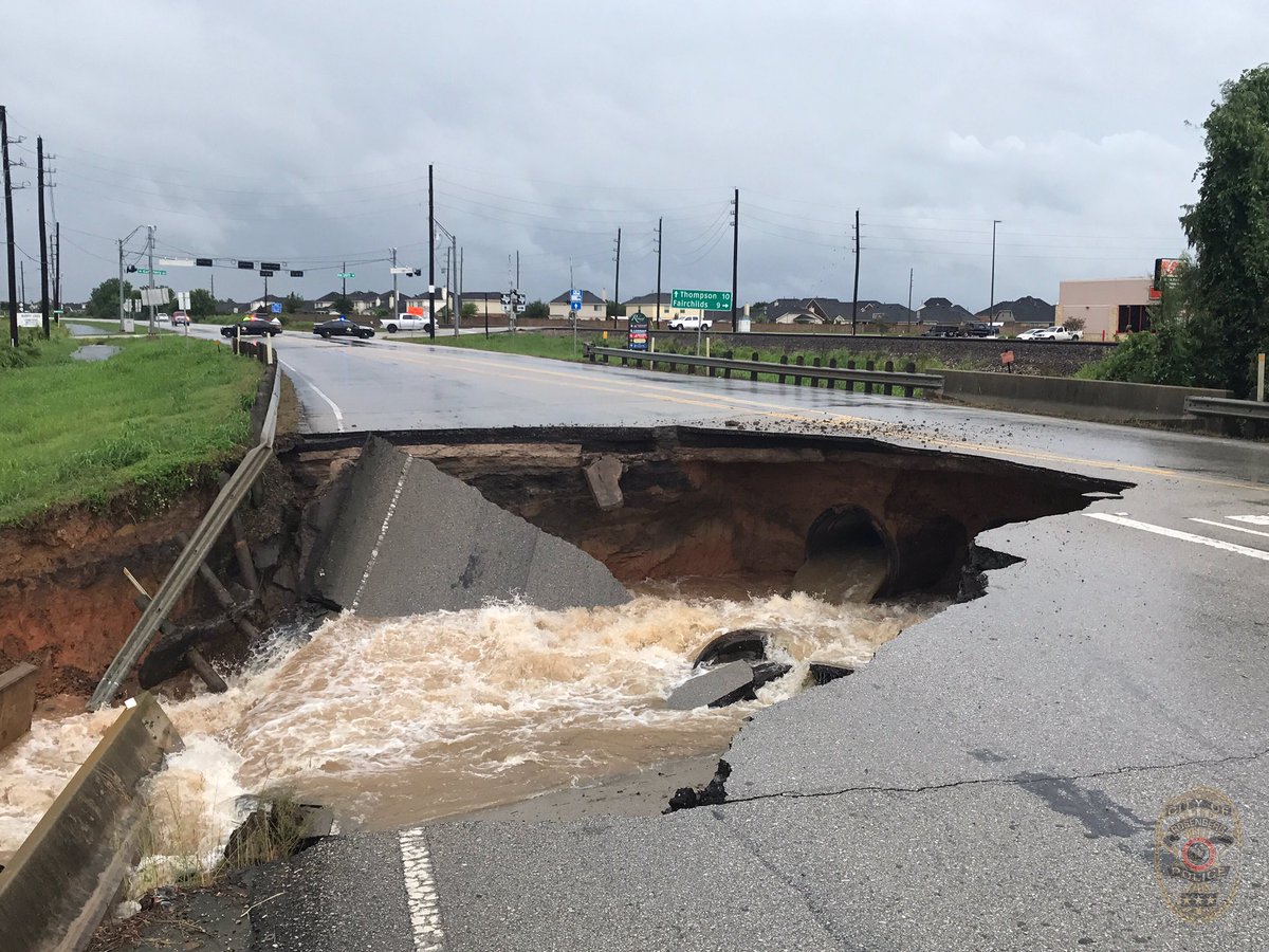
Re: ATL: HARVEY - Tropical Storm - Discussion
Rosenberg Police @RosenbergPolice
The 3900 block of FM 762 (in front of 24 HR fitness) has just collapsed. There is a massive sinkhole in the roadway. AVOID THE AREA! #Harvey
Embedded
12:02 PM · Aug 27, 2017
The 3900 block of FM 762 (in front of 24 HR fitness) has just collapsed. There is a massive sinkhole in the roadway. AVOID THE AREA! #Harvey
Embedded
12:02 PM · Aug 27, 2017
0 likes
Re: ATL: HARVEY - Tropical Storm - Discussion
with isolated storm totals as high as 50
inches, through Friday.
0 likes
Who is online
Users browsing this forum: No registered users and 163 guests