ATL: IRMA - Models
Moderator: S2k Moderators
-
1900hurricane

- Category 5

- Posts: 6063
- Age: 34
- Joined: Fri Feb 06, 2015 12:04 pm
- Location: Houston, TX
- Contact:
Re: ATL: IRMA - Models
That's quite the anticyclonic wave break on that 18Z GFS run. 500 mb heights in the Canadian Maritimes push up to about 600 dam with a big time ridge bridge over the cutoff trough.
2 likes
Contract Meteorologist. TAMU & MSST. Fiercely authentic, one of a kind. We are all given free will, so choose a life meant to be lived. We are the Masters of our own Stories.
Opinions expressed are mine alone.
Follow me on Twitter at @1900hurricane : Read blogs at https://1900hurricane.wordpress.com/
Opinions expressed are mine alone.
Follow me on Twitter at @1900hurricane : Read blogs at https://1900hurricane.wordpress.com/

Re: ATL: IRMA - Models
Steve wrote:Landfall is is 8 1/2 days from 18z today which means the storm hits NYC Sunday morning at 1am. 8 1/2 days is a long time in the model world but inside of model "fantasy land". And I'd caution everyone that the GFS and European haven't exactly been good in the mid-range which is what we'll be in throughout the labor day weekend. Unless all tracks come into agreement, don't expect to see the real solution, unless one accidentally hits it, before next Tuesday when we get inside of 5 days.
IDK Steve the EURO was pretty good with Harv around 3-4 days. It was the first model to throw out the wacky mid TX coast hit then bounced back to MX then back up the coast. Probably the reason the NHC is weighing so heavily on it this year. By far it has out performed the GFS as we all know...I also like the UKMET model this year...Not bad squirrely has the others. JMO
1 likes
-
Frank P
- S2K Supporter

- Posts: 2779
- Joined: Fri Aug 29, 2003 10:52 am
- Location: Biloxi Beach, Ms
- Contact:
Re: ATL: IRMA - Models
Honestly right now I am favoring one of the more consistent models.. the SIM.... often referred to as the Sports Illustrated Model...
S FL to Canada to England might end up getting this storm... heck why not all.. crazy days ahead... however, the Gulf is closed for business for at least the next two weeks... Nothing can go it there as I find that scenario most "Offensive"
S FL to Canada to England might end up getting this storm... heck why not all.. crazy days ahead... however, the Gulf is closed for business for at least the next two weeks... Nothing can go it there as I find that scenario most "Offensive"
2 likes
-
Spacecoast

- Category 2

- Posts: 773
- Joined: Thu Aug 31, 2017 2:03 pm
Re: ATL: IRMA - Models
Is that (soon to be) Jose hitting Miami hour @360?
It is interesting how Jose seems to disappear on some model runs.
It is interesting how Jose seems to disappear on some model runs.
0 likes
-
stormreader
Re: ATL: IRMA - Models
ROCK wrote:Steve wrote:Landfall is is 8 1/2 days from 18z today which means the storm hits NYC Sunday morning at 1am. 8 1/2 days is a long time in the model world but inside of model "fantasy land". And I'd caution everyone that the GFS and European haven't exactly been good in the mid-range which is what we'll be in throughout the labor day weekend. Unless all tracks come into agreement, don't expect to see the real solution, unless one accidentally hits it, before next Tuesday when we get inside of 5 days.
IDK Steve the EURO was pretty good with Harv around 3-4 days. It was the first model to throw out the wacky mid TX coast hit then bounced back to MX then back up the coast. Probably the reason the NHC is weighing so heavily on it this year. By far it has out performed the GFS as we all know...I also like the UKMET model this year...Not bad squirrely has the others. JMO
Welcome Back!
0 likes
Re: ATL: IRMA - Models
Sandy was 946mb so close
otowntiger wrote:AxaltaRacing24 wrote:
Pretty unrealistic on strength there. No way it will hold that kind of pressure that far north.

1 likes


Re: ATL: IRMA - Models
storm4u wrote:Sandy was 946mb so closeotowntiger wrote:AxaltaRacing24 wrote:http://i.imgur.com/zMp3EuU.png
Pretty unrealistic on strength there. No way it will hold that kind of pressure that far north.
Even the Euro which is usually the more reserved in terms of pressures of TCs was down to 920 east of Florida. While GFS depiction may not come to fruition, something in the guidance suggest pressures will be quite low.
1 likes
The above post and any post by Ntxw is NOT an official forecast and should not be used as such. It is just the opinion of the poster and may or may not be backed by sound meteorological data. It is NOT endorsed by any professional institution including Storm2k. For official information, please refer to NWS products.
Help support Storm2K!

Re: ATL: IRMA - Models
Frank P wrote:Honestly right now I am favoring one of the more consistent models.. the SIM.... often referred to as the Sports Illustrated Model...
S FL to Canada to England might end up getting this storm... heck why not all.. crazy days ahead... however, the Gulf is closed for business for at least the next two weeks... Nothing can go it there as I find that scenario most "Offensive"
agree I could use a break around here...
2 likes

Re: ATL: IRMA - Models
ROCK wrote:Steve wrote:Landfall is is 8 1/2 days from 18z today which means the storm hits NYC Sunday morning at 1am. 8 1/2 days is a long time in the model world but inside of model "fantasy land". And I'd caution everyone that the GFS and European haven't exactly been good in the mid-range which is what we'll be in throughout the labor day weekend. Unless all tracks come into agreement, don't expect to see the real solution, unless one accidentally hits it, before next Tuesday when we get inside of 5 days.
IDK Steve the EURO was pretty good with Harv around 3-4 days. It was the first model to throw out the wacky mid TX coast hit then bounced back to MX then back up the coast. Probably the reason the NHC is weighing so heavily on it this year. By far it has out performed the GFS as we all know...I also like the UKMET model this year...Not bad squirrely has the others. JMO
3-4 days is next Wednesday and Thursday. That's what I said ("..don't expect to see the solution...before Tuesday" which is 5 days). Euro lost it for a while as did the GFS if you remember back to the 5-6 day period. It was to emerge off the Yucatan as a ripple in the isobars and then 92L was a ripple on the way up toward Tallahassee.
As for the 2 day verifications for 2017 posted about 3 pages back, I'm assuming "ECMF" is ECMWF with only 4 characters. CMC is outperforming everything but the NHC and some other model that begins with a C that I don't know what it is (possibly something related to COAMPS or something).
0 likes
-
AxaltaRacing24
- Category 5
- Posts: 1774
- Age: 25
- Joined: Wed Jul 27, 2016 11:14 am
- Location: Jupiter, FL
Re: ATL: IRMA - Models
The one thing that I am concerned about is that no matter how powerful the windshield wiping is, we still have our 3 best models showing landfalls, which is the last thing this country needs.
3 likes
-
ColdMiser123

- Professional-Met

- Posts: 905
- Age: 29
- Joined: Mon Sep 26, 2016 3:26 pm
- Location: Northeast US
Re: ATL: IRMA - Models
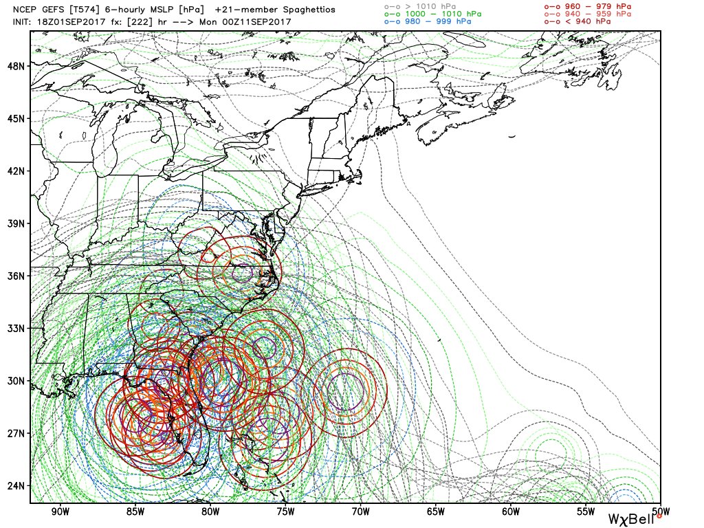
The GEFS have a ridiculous signal into Florida at 18z.
0 likes
B.S., M.S., Meteorology & Atmospheric Science
-
Blown Away

- S2K Supporter
- Posts: 10253
- Joined: Wed May 26, 2004 6:17 am
Re: ATL: IRMA - Models
ColdMiser123 wrote:The GEFS have a ridiculous signal into Florida at 18z.
Can you post image?
0 likes
Hurricane Eye Experience: David 79, Irene 99, Frances 04, Jeanne 04, Wilma 05… Hurricane Brush Experience: Andrew 92, Erin 95, Floyd 99, Matthew 16, Irma 17, Ian 22, Nicole 22…
-
ColdMiser123
- Professional-Met
- Posts: 905
- Age: 29
- Joined: Mon Sep 26, 2016 3:26 pm
- Location: Northeast US
Re: ATL: IRMA - Models
Blown Away wrote:ColdMiser123 wrote:The GEFS have a ridiculous signal into Florida at 18z.
Can you post image?
Had to do a double take when I first ran through this on WSI.

1 likes
B.S., M.S., Meteorology & Atmospheric Science
-
ColdMiser123
- Professional-Met
- Posts: 905
- Age: 29
- Joined: Mon Sep 26, 2016 3:26 pm
- Location: Northeast US
Re: ATL: IRMA - Models
18z is posted above, and should be out soon on Tidbits.
Last edited by ColdMiser123 on Fri Sep 01, 2017 6:25 pm, edited 2 times in total.
0 likes
B.S., M.S., Meteorology & Atmospheric Science
-
AxaltaRacing24
- Category 5
- Posts: 1774
- Age: 25
- Joined: Wed Jul 27, 2016 11:14 am
- Location: Jupiter, FL
Re: ATL: IRMA - Models
ColdMiser123 wrote:Blown Away wrote:ColdMiser123 wrote:The GEFS have a ridiculous signal into Florida at 18z.
Can you post image?
Had to do a double take when I first ran through this on WSI.
That's cruel
1 likes

Re: ATL: IRMA - Models
ColdMiser123 wrote:RL3AO wrote:
This is 12z. 18z is posted above, and should be out soon on Tidbits.
Oops. Didn't look at that. Assumed it was out since others were talking about it.
2 likes
Re: ATL: IRMA - Models
0 likes
-
AxaltaRacing24
- Category 5
- Posts: 1774
- Age: 25
- Joined: Wed Jul 27, 2016 11:14 am
- Location: Jupiter, FL
-
SouthFLTropics

- Category 5
- Posts: 4258
- Age: 50
- Joined: Thu Aug 14, 2003 8:04 am
- Location: Port St. Lucie, Florida
Re: ATL: IRMA - Models
HMON at 120 Hours...About 1/2 a degree north

0 likes
Fourth Generation Florida Native
Personal Storm History: David 79, Andrew 92, Erin 95, Floyd 99, Irene 99, Frances 04, Jeanne 04, Wilma 05, Matthew 16, Irma 17, Ian 22, Nicole 22, Milton 24
Personal Storm History: David 79, Andrew 92, Erin 95, Floyd 99, Irene 99, Frances 04, Jeanne 04, Wilma 05, Matthew 16, Irma 17, Ian 22, Nicole 22, Milton 24
-
AxaltaRacing24
- Category 5
- Posts: 1774
- Age: 25
- Joined: Wed Jul 27, 2016 11:14 am
- Location: Jupiter, FL

Who is online
Users browsing this forum: No registered users and 36 guests