ATL: IRMA - Models
Moderator: S2k Moderators

-
stormreader
Re: ATL: IRMA - Models
Euro I think is now very close. It has landfall very near the top of Fl or as I think the very uppermost keys. Think a very very slight adjust west over next 24 to 36 hours is most likely. Looking more likely no more west component at landfall, but thinking landfall just at uppermost keys.
0 likes
-
BensonTCwatcher

- Category 5

- Posts: 1050
- Joined: Sat Aug 28, 2004 10:11 pm
- Location: Southport NC
Re: ATL: IRMA - Models
RL3AO wrote:NHC
https://pbs.twimg.com/media/DJD4saqWsAEFjyh.jpg
Euro
https://pbs.twimg.com/media/DJD4tipXcAQ_WBc.jpg
NHC
https://pbs.twimg.com/media/DJD4ugdW0AAOQ-H.jpg
HWRF
https://pbs.twimg.com/media/DJD4v1iXkAE1wNM.jpg
CMC
https://i.imgur.com/0wiFKaF.png
GEFS
https://i.imgur.com/0IrFB22.png
Make no mistake. We have a damn good consensus now.
On a specific note- This whole group of models looks to wring a LOT of water out as it travels upstate toward western SC And NC. West of Charlotte and Columbia the elevation rises quickly and that means flash flooding with epic rain rates. The cyclonic shear will cause problems as well upstate on top of the coastal surge.
1 likes
-
northjaxpro

- S2K Supporter

- Posts: 8900
- Joined: Mon Sep 27, 2010 11:21 am
- Location: Jacksonville, FL
Re: ATL: IRMA - Models
gtalum wrote:northjaxpro wrote:Yeah, it is really getting clearer now on a consensus that the entire Florida peninsula is likely to get severely impacted by Irma. This run has shifted right up the spine of the state.
The models have zoned in this scenario or at minimum, the East Coast scrapper all the way up the coast.
Either scenario would be catastrophic no matter how you slice it. .
It's not "right up the spine". It enters SSW of miami and exits around Daytona. If this track verifies the entire Metro SEFL is in the eastern eyewall though. It's also basically in consensus with GFS and the official NHC track.
I stated two different scenarios in that post to state either option Irma does verify it mwill bring unbelievable damage to the state. Irma would still get inland enough to devastate areas as far north inland traversing north. God Bless you. Be safe OK!
Last edited by northjaxpro on Wed Sep 06, 2017 1:50 pm, edited 2 times in total.
0 likes
NEVER, EVER SAY NEVER in the tropics and weather in general, and most importantly, with life itself!!
________________________________________________________________________________________
Fay 2008 Beryl 2012 Debby 2012 Colin 2016 Hermine 2016 Julia 2016 Matthew 2016 Irma 2017 Dorian 2019
________________________________________________________________________________________
Fay 2008 Beryl 2012 Debby 2012 Colin 2016 Hermine 2016 Julia 2016 Matthew 2016 Irma 2017 Dorian 2019
Re: ATL: IRMA - Models
chris_fit wrote:It' the NAVGEM but it's up the spine of FL with a decent shift W....
Trend

Hmmm, I just can't see that happening with the way the trough seems to be digging down. Can't show it here, but when I was home for lunch, and looked at TWC's radar, I commented to hubs that the trough seemed to be VERY deep and digging in deeper and lower than it appeared they had thought....so I figured the trough was going to lift it up and away from FL.
Anybody see what I'm talking about? Just about the time Irma gets to Cuba, the trough looks like it will be down around the GoM and then swings east....like JUST ready to sweep the storm away with it.
0 likes
Cleo - 1964, Betsy - 1965, David - 1979, Andrew - 1992, Charlie (Francis, Ivan, Jeanne) - 2004, Irma - 2017, Ian - 2022, Milton - 2024

Re: ATL: IRMA - Models
Voltron wrote:Steve wrote:Hey Voltron,
This should answer your question fully. Run this NAM 12km resolution 12Z and look up toward the Great Lakes toward the end of the run. At 72 hours the high is centered across Wisconsin. 84 Hours it's on the U.P. of Michigan. It's a progressive high in that it's moving west to east (progressing) across the northern tier. If NAM went out farther, it comes east and blocks a NE alleyway out to sea. I only suggest this for overview, not for track of Irma.
https://www.tropicaltidbits.com/analysi ... 0&ypos=468
It may make more sense to you to look at it in shaded colors as well. Look at the 500mb Height & Anomalies. Red is high pressure. Blue is low pressure. Watch the evolution as the Trough lifts out, and this should explain better than I can what happens. The high is basically NE/N and NW of Irma which is why it has the west hook.
https://www.tropicaltidbits.com/analysi ... 0&ypos=601
This is great, really good stuff. It appears that it could be overstated or off a bit so in theory depending on the blocking ridge it still could be west or east 100 miles which based on how big this storm is would not really matter from effect wise
Oh for sure. The models aren't perfect with airmasses, so the shape, size, how far they go and in what direction type of information are always a little suspect. But when most models show scenario "x" upstream, you can watch the evolution as you run models ahead of a storm. You can then further watch the satellites covering the areas you're interested in (blocking high in the Northeast, trough off the east coast or whatever) and see if the actual weather is behaving as the modeling suggested. This isn't a particularly big high. But it reminds me of 2005 with the almost "square shaped" highs that kept coming off the mid-Atlantic states. This one is farther north than most of the summer highs that came off the US East Coast in 2005. Consequently, Irma is able to get possibly to Kentucky or even southern Indiana before turning ENE and going out. It may only be as far north as North Carolina, but that's still a good ways inland from a hit near Miami. Eventually the energy gets caught up in the "westerlies" which is the W-E flow across the horse latitudes and north. Again, hope it helps. I'm not a scientist at all, so sorry if this came across as too basic.
1 likes
Re: ATL: IRMA - Models
AutoPenalti wrote:

Oh my lord
Last edited by caneseddy on Wed Sep 06, 2017 1:53 pm, edited 1 time in total.
0 likes
-
MatthewsRevenge
Re: ATL: IRMA - Models
It's like what y'all said when models trended east that Euro would go the same way, Euro is now going the same way GFS and UK is going. Simple, right?
0 likes
-
canetracker

- S2K Supporter
- Posts: 751
- Age: 63
- Joined: Wed Jul 27, 2005 8:49 pm
- Location: Suburbia New Orleans...Harahan, LA
Re: ATL: IRMA - Models
chris_fit wrote:Can someone post the latest GFS and ECMF Ensemble member runs?
 <<<This is 00z, 12z not available yet
 <<<12z
Last edited by canetracker on Wed Sep 06, 2017 1:55 pm, edited 1 time in total.
2 likes
-
pokkeherrie
- Tropical Wave

- Posts: 9
- Joined: Sun Sep 03, 2017 11:32 pm
- Location: west palm beach, fl
Re: ATL: IRMA - Models
SouthFLTropics wrote:TheStormExpert wrote:Just when we were getting a consensus the Euro goes and throws a wrench in things.
We have a pretty good consensus...It just isn't the consensus that any of us in SE Florida want. On 12z the GFS, HMON, UKMET, HWRF, CMC, and now Euro have all trended to the west pretty much right on, just inland, or just off the coast of SE Florida. It probably won't but I hope this puts away the foolishness of local media outlets jumping on one model run and declaring that we're in the clear. Follow the NHC...They're the best in the business.

Call them out on it on their blogs. Demand better! They will read it and either take you seriously and offer better explanations in the future or play teaser to a base of ignoramuses. That's all you can do. NHC is the best and the one true authority. Once in a while they get behind a model on verification, but they'll always explain changes in the storm-specific Discussions.
3 likes
-
tolakram
- Admin

- Posts: 20179
- Age: 62
- Joined: Sun Aug 27, 2006 8:23 pm
- Location: Florence, KY (name is Mark)
Re: ATL: IRMA - Models
12z GEFS

1 likes
M a r k
- - - - -
Join us in chat: Storm2K Chatroom Invite. Android and IOS apps also available.
The posts in this forum are NOT official forecasts and should not be used as such. Posts are NOT endorsed by any professional institution or STORM2K.org. For official information and forecasts, please refer to NHC and NWS products.
Re: ATL: IRMA - Models
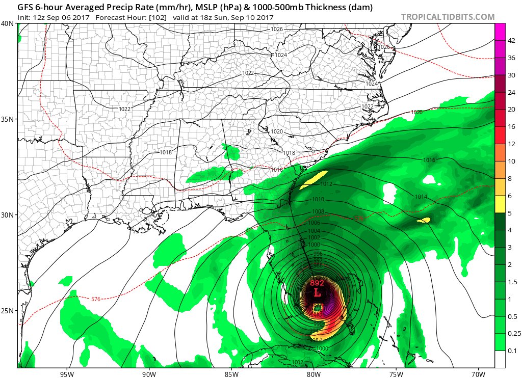
AutoPenalti wrote:
Not for the faint-hearted.
The only criticism I would make about this graphic is that the eye is way too small.
The area they are depicting as the eye is only about 8-10 miles. The eye itself is more like 30-40 miles.
2 likes
Cleo - 1964, Betsy - 1965, David - 1979, Andrew - 1992, Charlie (Francis, Ivan, Jeanne) - 2004, Irma - 2017, Ian - 2022, Milton - 2024
-
Jevo

- S2K Supporter
- Posts: 1729
- Age: 47
- Joined: Tue Aug 03, 2004 8:45 pm
- Location: The Flemish Cap
- Contact:
Re: ATL: IRMA - Models
miamijaaz wrote:Euro exists to the Atlantic at around St. Augustine at 120 HRS. That's a lot of inland real estate it goes over.
Edit: More like Daytona.
Most of that inland is hot swamp.. Florida does little in the way of weakening well defined systems.
2 likes
Disclaimer: 50% of the time I have no clue of what I am talking about. Chances are I am taking a less than educated guess that sounds good because 10 years ago I stole Mike Watkins book 'The Hurricane and its Impact'. For official information please direct yourself to the NHC and their cadre of weather geniuses.
-
Evil Jeremy

- S2K Supporter
- Posts: 5463
- Age: 32
- Joined: Mon Apr 10, 2006 2:10 pm
- Location: Los Angeles, CA
Re: ATL: IRMA - Models
Michele B wrote:Hmmm, I just can't see that happening with the way the trough seems to be digging down. Can't show it here, but when I was home for lunch, and looked at TWC's radar, I commented to hubs that the trough seemed to be VERY deep and digging in deeper and lower than it appeared they had thought....so I figured the trough was going to lift it up and away from FL.
Anybody see what I'm talking about? Just about the time Irma gets to Cuba, the trough looks like it will be down around the GoM and then swings east....like JUST ready to sweep the storm away with it.
Listen to the NHC. Prepare for a disaster. Don't wait on a magic trough to redirect Irma at the last minute. NHC currently forecasts a major hurricane impacting South Florida in 4 days time. That is the bottom line.
1 likes
Frances 04 / Jeanne 04 / Katrina 05 / Wilma 05 / Fay 08 / Debby 12 / Andrea 13 / Colin 16 / Hermine 16 / Matthew 16 / Irma 17


Re: ATL: IRMA - Models
PerfectStorm wrote:Any professional estimates of wind speeds in Hillsborough County based on the Spine/East Coast track?
Can't speak for speed, but mostly out of the north, which is an off-shore flow, good for Tampa.
1 likes
Cleo - 1964, Betsy - 1965, David - 1979, Andrew - 1992, Charlie (Francis, Ivan, Jeanne) - 2004, Irma - 2017, Ian - 2022, Milton - 2024
Re: ATL: IRMA - Models
I ask this question in all sincerity: can anyone recall a 96hr (4 day) forecast with 0 mile error? The consensus reached this afternoon is horrifying; and as a SE Florida resident, at this point I'd take a measly 50 mile error. Sure 50 miles one way or the other it's still going to be bad, but I'm looking at the slightest hope that this monstrous core gets away from the Metro area.
Grasping at straws here.
Grasping at straws here.
3 likes

Re: ATL: IRMA - Models
So this is going up the East Coast of FL then depending on when it turns north is what happens in GA/SC/NC. I am so confused on all of this, this is a very hard and complex track. It is almost better based on all the models whether inland or on the coast in all areas to just be prepared due to the size? Thoughts? I know this is model related but.....
0 likes
-
MatthewsRevenge
Who is online
Users browsing this forum: No registered users and 11 guests