Anyone have a link to a live video feed from the Turks and Caicos islands?
Thanks.
ATL: IRMA - Post-Tropical - Discussion
Moderator: S2k Moderators
Re: ATL: IRMA - Hurricane - Discussion
0 likes
Any forecast I make is based on my opinion only. Please refer to the NWS or NHC for official forecasts.

Re: ATL: IRMA - Hurricane - Discussion
tolakram wrote:Loops. Fortunately we won't see a cat 5 heading up this way very often.
https://weather.msfc.nasa.gov/cgi-bin/get-abi?satellite=GOESEastconusband02&lat=22&lon=-70&width=1000&height=800&zoom=4&type=Animation&numframes=30&quality=92
http://rammb-slider.cira.colostate.edu/?sat=goes-16&sec=conus&x=7882&y=6350&z=2&im=48&ts=1&st=0&et=0&speed=130&motion=loop&map=1&lat=0&p%5B0%5D=1&opacity%5B0%5D=1&hidden%5B0%5D=0&pause=0&slider=-1&hide_controls=0&mouse_draw=0&s=rammb-slider
Thats great news. Here in the southern part of Dominican Republic it is now that we are feeling some Tropical Storm winds and gusts with a lot of rain and thunderstorms. Until now it was a quiet day with some moderate winds and little rain.
1 likes

Re: ATL: IRMA - Hurricane - Discussion
bob rulz wrote:It's getting that buzzsaw look on visible, presentation is as good as it's been since east of the Leewards. It doesn't look as good on IR though. Hard to guess what it's really doing without the direct observations. Is there a plane in there now?
Most likely Irma's restrengthening/redeepening as the CDO is outside of any range of land, and the waters over the Bahamas are some of the warmest she's travelled on.
0 likes
-
Weatherhorse

- Tropical Low

- Posts: 22
- Age: 50
- Joined: Mon Jun 25, 2012 3:08 pm
- Location: NW Marion County, FL
Re: ATL: IRMA - Hurricane - Discussion
Sanibel wrote:The word I got that I-75 was a "parking lot" was false and a relative just reported to me that they flew up 75 no problem to Tampa...I apologize for the previous false report...
Taking pots and planters into garage now...
The turnpike and I 75 have been slow/intermittently stopped from south of Ocala through Gainesville. I've been keeping an eye on the traffic cams on FL511.
0 likes
"Prepare for the worst and hope for the best." Anon.
The posts in this forum are NOT official forecasts and should not be used as such. They are just the opinion of the poster and may or may not be backed by sound meteorological data. They are NOT endorsed by any professional institution or STORM2K. For official information, please refer to products from the NHC and NWS.
Re: ATL: IRMA - Hurricane - Discussion
Look at the lightning firing in the eyewall and the symmetry that's reforming. (sorry for the glitching in the gif, GOES' saving feature hasn't been up to par..)
[i mg]http://weather.cod.edu/satrad/exper/saves/animations/CODNEXLAB-GOES16-True-Color-20:07Z-20170907_6416-6516-1-100.gif[/img]
[i mg]http://weather.cod.edu/satrad/exper/saves/animations/CODNEXLAB-GOES16-True-Color-20:07Z-20170907_6416-6516-1-100.gif[/img]
2 likes
-
tarheelprogrammer

- S2K Supporter

- Posts: 1793
- Joined: Mon Mar 28, 2016 9:25 pm
- Location: Raleigh, NC area (Garner, NC)
Re: ATL: IRMA - Hurricane - Discussion
When does recon go back into the storm? 
0 likes
My posts are not official forecasts. They are just my opinion and may or may not be backed by sound meteorological data. They are NOT endorsed by any professional institution or storm2k.org. For official information, please refer to the NHC and NWS products.
Re: ATL: IRMA - Hurricane - Discussion
Weatherhorse wrote:Sanibel wrote:The word I got that I-75 was a "parking lot" was false and a relative just reported to me that they flew up 75 no problem to Tampa...I apologize for the previous false report...
Taking pots and planters into garage now...
The turnpike and I 75 have been slow/intermittently stopped from south of Ocala through Gainesville. I've been keeping an eye on the traffic cams on FL511.
It's very heavy north of wildwood due to the turnpike dumping in. it looks ok south of there..for now.
0 likes
-
tropicwatch

- Category 5

- Posts: 3426
- Age: 62
- Joined: Sat Jun 02, 2007 10:01 am
- Location: The Villages, Florida
- Contact:
Re: ATL: IRMA - Hurricane - Discussion
tarheelprogrammer wrote:When does recon go back into the storm?
Next flight takes off around 4pm central time.
1 likes
Tropicwatch
Agnes 72', Eloise 75, Elena 85', Kate 85', Charley 86', Florence 88', Beryl 94', Dean 95', Erin 95', Opal 95', Earl 98', Georges 98', Ivan 2004', Arlene 2005', Dennis 2005', Ida 2009' Debby 2012' Irma 2017' Michael 2018'
Agnes 72', Eloise 75, Elena 85', Kate 85', Charley 86', Florence 88', Beryl 94', Dean 95', Erin 95', Opal 95', Earl 98', Georges 98', Ivan 2004', Arlene 2005', Dennis 2005', Ida 2009' Debby 2012' Irma 2017' Michael 2018'
Re: ATL: IRMA - Hurricane - Discussion
tarheelprogrammer wrote:When does recon go back into the storm?
Around 5pm EDT, I think they'll likely find an intensifying Irma, she looks great, CDO expanding, eye clearing out and symmetry reforming. She's looking great again..
1 likes

Re: ATL: IRMA - Hurricane - Discussion
Sanibel wrote:The word I got that I-75 was a "parking lot" was false and a relative just reported to me that they flew up 75 no problem to Tampa...I apologize for the previous false report...
Taking pots and planters into garage now...
Well, a friend of mine said she just finished the drive and it took her 17 hours to go from S FL to N FL.
1 likes

Re: ATL: IRMA - Hurricane - Discussion
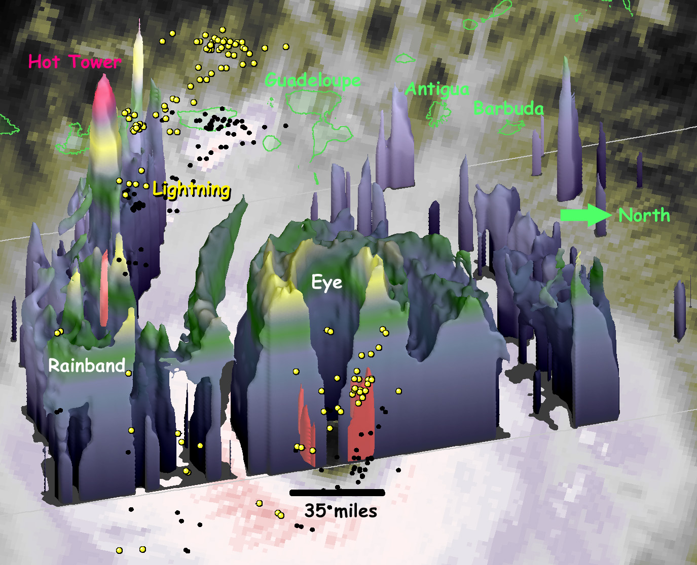
Hurricane Irma's Heat Engine Exposed
https://pmm.nasa.gov/articles/hurricane ... ne-exposed
At 1 PM EDT (1700 UTC) on September 5, 2017, the radar on the Global Precipitation Measuring Mission (GPM) satellite captured this 3D view of the heat engine inside of category-5 Hurricane Irma. Under the central ring of clouds that circles the eye, water that had evaporated from the ocean surface condenses, releases heat, and powers the circling winds of the hurricane. The radar on the GPM satellite is able to estimate how much water is falling as precipitation inside of the hurricane, which serves as a guide to how much energy is being released inside the hurricane's central "heat engine."
4 likes
-
Hurrilurker

- Category 2

- Posts: 738
- Joined: Mon Jun 09, 2003 3:32 pm
- Location: San Francisco, CA
Re: ATL: IRMA - Hurricane - Discussion
panamatropicwatch wrote:Irma still a little north of forecast track.
Terrible news for those southern islands in the Bahamas chain, they may now get right side eye wall hits, or pretty close to it.
0 likes
-
GeneratorPower

- S2K Supporter
- Posts: 1648
- Age: 46
- Joined: Sun Dec 18, 2005 11:48 pm
- Location: Huntsville, AL
Re: ATL: IRMA - Hurricane - Discussion
Here in Naples / Fort Myers. Several of my acquaintances cancelled their evacuation plans and storm preps when the Miami east shift in the models occurred yesterday. Really dumb. However: our entire neighborhood in Fort Myers has taken very seriously and has been putting up full shutters on everything. Overall I'm very impressed with folks taking seriously just in case we get a western track over SW Florida.
1 likes
-
Weatherhorse
- Tropical Low
- Posts: 22
- Age: 50
- Joined: Mon Jun 25, 2012 3:08 pm
- Location: NW Marion County, FL
Re: ATL: IRMA - Hurricane - Discussion
psyclone wrote:Weatherhorse wrote:Sanibel wrote:The word I got that I-75 was a "parking lot" was false and a relative just reported to me that they flew up 75 no problem to Tampa...I apologize for the previous false report...
Taking pots and planters into garage now...
The turnpike and I 75 have been slow/intermittently stopped from south of Ocala through Gainesville. I've been keeping an eye on the traffic cams on FL511.
It's very heavy north of wildwood due to the turnpike dumping in. it looks ok south of there..for now.
441 is still pretty clear between Ocala and Gainesville-can skirt some of the traffic that way as well.
1 likes
"Prepare for the worst and hope for the best." Anon.
The posts in this forum are NOT official forecasts and should not be used as such. They are just the opinion of the poster and may or may not be backed by sound meteorological data. They are NOT endorsed by any professional institution or STORM2K. For official information, please refer to products from the NHC and NWS.
Re: ATL: IRMA - Hurricane - Discussion
Hurricane Irma: Solar flares could wreak HAVOC on satellites as storm barrels towards US
THE sun has released two huge solar flares, prompting fears they could affect global communications at a time when satellites are desperately needed.
http://www.express.co.uk/news/science/8 ... satellites
THE sun has released two huge solar flares, prompting fears they could affect global communications at a time when satellites are desperately needed.
http://www.express.co.uk/news/science/8 ... satellites
0 likes
-
jasons2k

- Storm2k Executive

- Posts: 8290
- Age: 52
- Joined: Wed Jul 06, 2005 12:32 pm
- Location: The Woodlands, TX
Re: ATL: IRMA - Hurricane - Discussion
I keep seeing all these posts about ERCs. Irma is NOT and has NOT been undergoing eyewall replacement cycles. She has consistently had fluctuating concentric eyewalls for the last couple of days. Please stop calling every contraction or expansion and ERC - it's not what is happening. I've had to point this out a few times now and folks aren't getting it.
3 likes

Re: ATL: IRMA - Hurricane - Discussion
Slightly off topic but loosely related to the solar flare post.....
I have been trying to look at our local NWS radar (Tampa) and it hasn't updated since 3:19 p.m. Is anyone else having issues?
I have been trying to look at our local NWS radar (Tampa) and it hasn't updated since 3:19 p.m. Is anyone else having issues?
0 likes
Re: ATL: IRMA - Hurricane - Discussion
GCANE wrote:Hurricane Irma: Solar flares could wreak HAVOC on satellites as storm barrels towards US
THE sun has released two huge solar flares, prompting fears they could affect global communications at a time when satellites are desperately needed.
http://www.express.co.uk/news/science/8 ... satellites
Well, what a crappy time to have solar flares
4 likes
Re: ATL: IRMA - Hurricane - Discussion
jasons wrote:I keep seeing all these posts about ERCs. Irma is NOT and has NOT been undergoing eyewall replacement cycles. She has consistently had fluctuating concentric eyewalls for the last couple of days. Please stop calling every contraction or expansion and ERC - it's not what is happening. I've had to point this out a few times now and folks aren't getting it.
Especially not now, this is just reformation of symmetry. I do have to add, however, that it's been pretty interesting to see such seamless eyewall contractions and expansions, something I've never really seen before in hurricanes, even Patricia was undergoing a regular EWRC. Scary however that these monsters can simply expand their wind field without much if any of a hit to strength at all..
1 likes

Re: ATL: IRMA - Hurricane - Discussion
Could Irma's evacuation surpass Rita's and Matthew's?
0 likes
Who is online
Users browsing this forum: No registered users and 95 guests