ATL: IRMA - Post-Tropical - Discussion
Moderator: S2k Moderators
-
TheDreamTraveler

- Category 2

- Posts: 645
- Joined: Sun Aug 22, 2010 3:10 am
- Location: PA
Re: ATL: IRMA - Hurricane - Discussion
I'm wondering just how much damage Cuba could do to Irma before it gets away from it. If you guys remember Ike from 2008 it never fully recovered after passing through Cuba on its way to Texas. It's possible Irma doesn't fully recover either.
1 likes

-
HurricaneEdouard

- Tropical Storm

- Posts: 140
- Joined: Sun May 03, 2015 11:09 am
Re: ATL: IRMA - Hurricane - Discussion
Category 5 still? Pressure is likely in the 920s still, going by the missing pressures when winds are lowest.
URNT15 KNHC 090514
AF308 2411A IRMA HDOB 54 20170909
050430 2222N 07742W 6978 02782 9655 +120 +120 161112 118 101 043 00
050500 2222N 07744W 6966 02778 9632 +123 +123 162110 112 105 034 00
050530 2221N 07745W 6965 02759 9612 +126 +126 164113 114 110 031 03
050600 2221N 07746W 6970 02730 9587 +128 +128 166112 113 /// /// 03
050630 2220N 07747W 6975 02702 9557 +130 +130 169111 114 /// /// 03
050700 2219N 07749W 6962 02691 9523 +129 //// 167104 109 /// /// 05
050730 2219N 07750W 6972 02646 9486 +134 +134 170097 102 139 060 03
050800 2219N 07752W 6965 02621 9444 +138 +138 170085 094 135 024 00
050830 2218N 07753W 6963 02606 9400 +144 //// 172070 082 123 018 05
050900 2218N 07755W 6972 02577 9365 +150 //// 167060 064 074 005 01
050930 2218N 07757W 6970 02559 //// +147 //// 164051 058 054 004 05
051000 2217N 07759W 6970 02546 //// +148 //// 162038 047 041 004 05
051030 2217N 07801W 6967 02543 //// +155 //// 156021 034 021 003 01
051100 2216N 07803W 6969 02537 //// +161 //// 127010 015 021 003 05
051130 2215N 07804W 6967 02540 //// +155 //// 078005 008 008 002 05
051200 2214N 07806W 6963 02548 //// +150 //// 013006 007 014 001 05
051230 2213N 07808W 6970 02545 //// +154 //// 010007 008 /// /// 05
051300 2214N 07809W 6962 02556 //// +157 //// 040012 014 /// /// 05
051330 2215N 07811W 6970 02549 9329 +173 //// 047019 021 /// /// 05
051400 2216N 07813W 6967 02560 9335 +175 //// 044028 032 010 006 01
$$
Last edited by HurricaneEdouard on Sat Sep 09, 2017 12:33 am, edited 1 time in total.
0 likes
You know you're a hurricane nut, when your main source of adrenaline is reading old hurricane advisories...
-
Evil Jeremy

- S2K Supporter

- Posts: 5463
- Age: 32
- Joined: Mon Apr 10, 2006 2:10 pm
- Location: Los Angeles, CA
Re: ATL: IRMA - Hurricane - Discussion
A clear northward component to Irma over the past several hours. The next couple will say if it is a wobble or the start of a long term motion. It looks more NW than WNW to me, based on the images so far, although the presence of Cuba could be deceiving me. That's why we need to see the longer term motion.
The 5pm advisory had Irma at 22.4N at 5am. She might be that far north by 2am.
Likewise, the 11pm advisory had Irma at 22.6N at 11am. Lets see when she makes it that far North.
The 5pm advisory had Irma at 22.4N at 5am. She might be that far north by 2am.
Likewise, the 11pm advisory had Irma at 22.6N at 11am. Lets see when she makes it that far North.
1 likes
Frances 04 / Jeanne 04 / Katrina 05 / Wilma 05 / Fay 08 / Debby 12 / Andrea 13 / Colin 16 / Hermine 16 / Matthew 16 / Irma 17
Re: ATL: IRMA - Hurricane - Discussion
Evil Jeremy wrote:A clear northward component to Irma over the past several hours. The next couple will say if it is a wobble or the start of a long term motion. It looks more NW than WNW to me, based on the images so far, although the presence of Cuba could be deceiving me. That's why we need to see the longer term motion.
The 5pm advisory had Irma at 22.4N at 5am. She might be that far north by 2am.
Likewise, the 11pm advisory had Irma at 22.6N at 11am. Lets see when she makes it that far North.
nope. it is due west according to the aircraft data. 22.2N, 78.1W was where the lowest pressure was found
2 likes

Re: ATL: IRMA - Hurricane - Discussion
Zarniwoop wrote:I just can't fathom how she's going to hold together.
Guess that's why nobody asks me.
If she goes over land anything is possible, she could very well dislike it intensely. or not.. idk.. I still have a visual image in my mind of the vaporizing model that went over Cuba only because it looked so ridiculous..
I'm real time analyzing thinking out aloud: I could wake up tomorrow and Irma could be as strong as ever over water away from Cuba..
Also at this time of night no one in their right mind is gonna turn around and race home based off 1hr of data. At least I hope not.
Far far from over.. just real time observations late at night..
0 likes
-
FLpanhandle91

- Category 5

- Posts: 1039
- Age: 34
- Joined: Mon Sep 13, 2010 3:50 pm
- Location: Fort Walton Beach, FL
Re: ATL: IRMA - Hurricane - Discussion
Alyono wrote:still due west according to the aircraft data
Honest question when dealing with a storm and anyzing such tiny distances: How accurate is a recon fix really? I am ignorant on how the data is gathered, but the resolution on some floaters these days seems to be a more telling way to analyze small changes in direction which really matter in this current situation..
0 likes
Re: ATL: IRMA - Hurricane - Discussion
FLpanhandle91 wrote:Alyono wrote:still due west according to the aircraft data
Honest question when dealing with a storm and anyzing such tiny distances: How accurate is a recon fix really? I am ignorant on how the data is gathered, but the resolution on some floaters these days seems to be a more telling way to analyze small changes in direction which really matter in this current situation..
the recon fix is the most accurate method of fixing there is! It is an in situ observation. Radar is next most accurate The satellite is always going to be slightly off due to projection as well as when a different part of the eye clears out, it can create an apparent movement
3 likes

Re: ATL: IRMA - Hurricane - Discussion
TheDreamTraveler wrote:I'm wondering just how much damage Cuba could do to Irma before it gets away from it. If you guys remember Ike from 2008 it never fully recovered after passing through Cuba on its way to Texas. It's possible Irma doesn't fully recover either.
I believe what was particularly damaging to Ike is that it traveled almost the entire length of Cuba, right down the middle, for about two days--Irma will very likely remain away from the mountainous area.
0 likes
The above post is not official and should not be used as such. It is the opinion of the poster and may or may not be backed by sound meteorological data. It is not endorsed by any professional institution or storm2k.org. For official information, please refer to the NHC and NWS products.
-
tarheelprogrammer

- S2K Supporter
- Posts: 1793
- Joined: Mon Mar 28, 2016 9:25 pm
- Location: Raleigh, NC area (Garner, NC)
Re: ATL: IRMA - Hurricane - Discussion
Storm looks ragged on IR currently. Cuba is giving it a beating. UKMET was right all those runs ago.
0 likes
My posts are not official forecasts. They are just my opinion and may or may not be backed by sound meteorological data. They are NOT endorsed by any professional institution or storm2k.org. For official information, please refer to the NHC and NWS products.
-
Sciencerocks
- Category 5
- Posts: 10181
- Age: 40
- Joined: Thu Jul 06, 2017 1:51 am
Re: ATL: IRMA - Recon Discussion Thread
Still cat5
050730 2219N 07750W 6972 02646 9486 +134 +134 170097 102 139 060 03
050800 2219N 07752W 6965 02621 9444 +138 +138 170085 094 135 024 00
050730 2219N 07750W 6972 02646 9486 +134 +134 170097 102 139 060 03
050800 2219N 07752W 6965 02621 9444 +138 +138 170085 094 135 024 00
0 likes
-
Aric Dunn
- Category 5
- Posts: 21238
- Age: 43
- Joined: Sun Sep 19, 2004 9:58 pm
- Location: Ready for the Chase.
- Contact:
Re: ATL: IRMA - Hurricane - Discussion
Cant just use lowest pressure around land..
the wind shift is also the center... it definately wobbled to the wnw again.. just have to see if that continues.

the wind shift is also the center... it definately wobbled to the wnw again.. just have to see if that continues.
Last edited by Aric Dunn on Sat Sep 09, 2017 12:42 am, edited 1 time in total.
1 likes
Note: If I make a post that is brief. Please refer back to previous posts for the analysis or reasoning. I do not re-write/qoute what my initial post said each time.
If there is nothing before... then just ask
Space & Atmospheric Physicist, Embry-Riddle Aeronautical University,
I believe the sky is falling...
If there is nothing before... then just ask
Space & Atmospheric Physicist, Embry-Riddle Aeronautical University,
I believe the sky is falling...
-
craptacular
- Category 2
- Posts: 581
- Joined: Wed Aug 02, 2006 9:17 pm
- Location: The Mad City, WI
Re: ATL: IRMA - Hurricane - Discussion
Alyono wrote:nope. it is due west according to the aircraft data. 22.2N, 78.1W was where the lowest pressure was found
Previous three fixes were at 22 degrees 8 minutes, 7 minutes, and 6 minutes North, respectively. Based on HDOBs from pass #4, it will be somewhere around the 14-16 minute range. Definitely gained some latitude.
1 likes
-
Digital-TC-Chaser
Re: ATL: IRMA - Hurricane - Discussion
FLpanhandle91 wrote:Alyono wrote:still due west according to the aircraft data
Honest question when dealing with a storm and anyzing such tiny distances: How accurate is a recon fix really? I am ignorant on how the data is gathered, but the resolution on some floaters these days seems to be a more telling way to analyze small changes in direction which really matter in this current situation..
@ this stage of the tracking game, Radar is the better tool than satellite and yeah agree
it is still tracking due W.
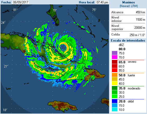
http://www.met.inf.cu/asp/genesis.asp?T ... AXw01a.gif
0 likes
-
znel52
Re: ATL: IRMA - Hurricane - Discussion
https://uploads.disquscdn.com/images/03 ... 45123a.gif
Storm is definitely going north of due west. Gaining latitude blatantly obvious in this radar loop.
Storm is definitely going north of due west. Gaining latitude blatantly obvious in this radar loop.
3 likes
-
craptacular
- Category 2
- Posts: 581
- Joined: Wed Aug 02, 2006 9:17 pm
- Location: The Mad City, WI
Re: ATL: IRMA - Main Recon Thread (Data only)
Product: Air Force Vortex Message (URNT12 KNHC)
Transmitted: 9th day of the month at 5:36Z
Agency: United States Air Force
Aircraft: Lockheed WC-130J Hercules with reg. number AF98-5308
Storm Number & Year: 11 in 2017
Storm Name: Irma (flight in the North Atlantic basin)
Mission Number: 24
Observation Number: 19
A. Time of Center Fix: 9th day of the month at 5:11:40Z
B. Center Fix Coordinates: 22°15'N 78°05'W (22.25N 78.0833W)
B. Center Fix Location: 60 statute miles (97 km) to the N (349°) from Camagüey, Cuba.
C. Minimum Height at Standard Level: 2,501m (8,205ft) at 700mb
D. Estimated (by SFMR or visually) Maximum Surface Wind Inbound: 131kts (~ 150.8mph)
E. Location of the Estimated Maximum Surface Wind Inbound: 13 nautical miles (15 statute miles) to the ENE (74°) of center fix
F. Maximum Flight Level Wind Inbound: From 158° at 124kts (From the SSE at ~ 142.7mph)
G. Location of Maximum Flight Level Wind Inbound: 23 nautical miles (26 statute miles) to the ENE (71°) of center fix
H. Minimum Sea Level Pressure: 931mb (27.50 inHg)
I. Maximum Flight Level Temp & Pressure Altitude Outside Eye: 11°C (52°F) at a pressure alt. of 3,053m (10,016ft)
J. Maximum Flight Level Temp & Pressure Altitude Inside Eye: 17°C (63°F) at a pressure alt. of 3,048m (10,000ft)
K. Dewpoint Temp & Sea Surface Temp (collected at same location as temp inside eye): Not Available
L. Eye Character: Closed
M. Eye Shape & Diameter: Circular with a diameter of 28 nautical miles (32 statute miles)
N. Fix Determined By: Penetration, Radar, Wind, Pressure and Temperature
N. Fix Level: 700mb
O. Navigational Fix Accuracy: 0.02 nautical miles
O. Meteorological Accuracy: 3 nautical miles
Remarks Section:
Maximum Flight Level Wind: 124kts (~ 142.7mph) which was observed 23 nautical miles (26 statute miles) to the ENE (71°) from the flight level center at 5:04:00Z
Dropsonde Surface Wind at Center: From 205° at 11kts (From the SSW at 13mph)
Maximum Flight Level Temp: 18°C (64°F) which was observed 7 nautical miles to the W (279°) from the flight level center
0 likes
-
Aric Dunn
- Category 5
- Posts: 21238
- Age: 43
- Joined: Sun Sep 19, 2004 9:58 pm
- Location: Ready for the Chase.
- Contact:
Re: ATL: IRMA - Hurricane - Discussion
znel52 wrote:https://uploads.disquscdn.com/images/03115325fa7ec12df19573ef2237e9aa16a33ff8f5ca2a6fc2b4f168b445123a.gif
Storm is definitely going north of due west. Gaining latitude blatantly obvious in this radar loop.
have you been making those longer loops yourself ? if so.. keep doing please.
2 likes
Note: If I make a post that is brief. Please refer back to previous posts for the analysis or reasoning. I do not re-write/qoute what my initial post said each time.
If there is nothing before... then just ask
Space & Atmospheric Physicist, Embry-Riddle Aeronautical University,
I believe the sky is falling...
If there is nothing before... then just ask
Space & Atmospheric Physicist, Embry-Riddle Aeronautical University,
I believe the sky is falling...
-
znel52
Re: ATL: IRMA - Hurricane - Discussion
Aric Dunn wrote:znel52 wrote:https://uploads.disquscdn.com/images/03115325fa7ec12df19573ef2237e9aa16a33ff8f5ca2a6fc2b4f168b445123a.gif
Storm is definitely going north of due west. Gaining latitude blatantly obvious in this radar loop.
have you been making those longer loops yourself ? if so.. keep doing please.
I can't take credit for it. Found it in the Wunderground blog comments lol
1 likes
Re: ATL: IRMA - Hurricane - Discussion
znel52 wrote:https://uploads.disquscdn.com/images/03115325fa7ec12df19573ef2237e9aa16a33ff8f5ca2a6fc2b4f168b445123a.gif
Storm is definitely going north of due west. Gaining latitude blatantly obvious in this radar loop.
Yep, I see it going north now. It is so amazing how just small differences could have such huge ramifications.
edit: and then on the last frame it looks like it wants to go west again for when its time for the next frame
Last edited by utweather on Sat Sep 09, 2017 12:50 am, edited 1 time in total.
0 likes
-
craptacular
- Category 2
- Posts: 581
- Joined: Wed Aug 02, 2006 9:17 pm
- Location: The Mad City, WI
Who is online
Users browsing this forum: No registered users and 93 guests