ATL: IRMA - Post-Tropical - Discussion
Moderator: S2k Moderators
-
LAwxrgal

- S2K Supporter

- Posts: 1763
- Joined: Tue Jul 06, 2004 1:05 pm
- Location: Reserve, LA (30 mi west of NOLA)
Re: ATL: IRMA - Hurricane - Discussion
GFS for several runs now (including the latest 12z) has gone with an explosive deepening phase once the storm leaves Cuba. While the actual number may probably be overdone, the trend itself is worrying. I hope everyone in the warned area is prepared to have a monster on their doorstep, but I hope it doesn't actually come to pass. Godspeed. 
Last edited by LAwxrgal on Sat Sep 09, 2017 11:00 am, edited 2 times in total.
0 likes
Andrew 92/Isidore & Lili 02/Bill 03/Katrina & Rita 05/Gustav & Ike 08/Isaac 12 (flooded my house)/Harvey 17/Barry 19/Cristobal 20/Claudette 21/Ida 21 (In the Eye)/Francine 24
Wake me up when November ends
Wake me up when November ends

Re: ATL: IRMA - Hurricane - Discussion
SFLcane wrote:Miami dade and broward down to 10% chance of hurricane force it's now more like a TS event down here. Glad serious impacts not expected here
I wouldn't disregard impact just yet. The way the eye is moving tells me SE FL isn't out of the woods at all.
5 likes
Re: ATL: IRMA - Hurricane - Discussion
LAwxrgal wrote:GFS for several runs now (including the latest 12z) has gone with an explosive deepening phase once the storm leaves Cuba. While the number may probably be overdone, the trend itself is worrying. I hope everyone in the warned area is prepared to have a monster on their doorstep. Godspeed.
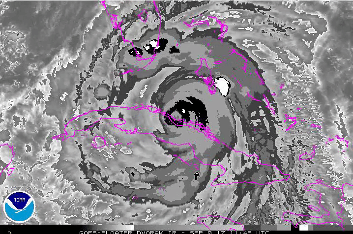
Not surprised, if you see the GOES satellite you can see the eye already clearing out with convection heavily firing.
0 likes
-
WeatherGuesser
- Category 5

- Posts: 2672
- Joined: Tue Jun 29, 2010 6:46 am
Re: ATL: IRMA - Hurricane - Discussion
I keep seeing people on other forums bragging about how they've been through this so many times before and it's really no big deal, and so on. They don't seem to understand or different this one is.
METS, is there significant reason to anticipate this returning to Cat 5 status before or at landfall?
METS, is there significant reason to anticipate this returning to Cat 5 status before or at landfall?
1 likes
-
AutoPenalti
- Category 5
- Posts: 4091
- Age: 29
- Joined: Mon Aug 17, 2015 4:16 pm
- Location: Ft. Lauderdale, Florida
Re: ATL: IRMA - Hurricane - Discussion
NO ONE is out of the woods yet, the cone it self outlines that a little shift east would affect Metro areas with Hurricane force winds.
1 likes
The posts in this forum are NOT official forecasts and should not be used as such. They are just the opinion of the poster and may or may not be backed by sound meteorological data. They are NOT endorsed by any professional institution or STORM2K. For official information, please refer to products from the NHC and NWS.
Model Runs Cheat Sheet:
GFS (5:30 AM/PM, 11:30 AM/PM)
HWRF, GFDL, UKMET, NAVGEM (6:30-8:00 AM/PM, 12:30-2:00 AM/PM)
ECMWF (1:45 AM/PM)
TCVN is a weighted averaged
-
stormreader
Re: ATL: IRMA - Hurricane - Discussion
Nice report on TWC. Storm intensity down some at Cat 3 125 mph. Forecast to be Cat 4 along Fl west coast. But weather host said he couldn't rule out it going to Cat 5 again. Storm surges at Tampa near 8 ft forecast now. 10-15 ft at Fort Myers an Naples.
0 likes
-
Lifeless
- Tropical Low

- Posts: 35
- Joined: Sun Aug 23, 2015 8:28 am
- Location: Extra-Tropical-London, UK
Re: ATL: IRMA - Hurricane - Discussion
https://twitter.com/NHC_Atlantic/status/906548124889571328
NHC has begun issuing hourly updates on Hurricane #Irma. These will continue until the eye is no longer visible on U.S. Doppler Radar.
NHC has begun issuing hourly updates on Hurricane #Irma. These will continue until the eye is no longer visible on U.S. Doppler Radar.
5 likes
Disclaimer: I am by no means even remotely a professional meteorologist, I'm just a Brit interested in tropical weather in the Atlantic. Always refer to the National Hurricane Center (NHC) or National Weather Service (NWS) for professional advice.
-
Evil Jeremy

- S2K Supporter
- Posts: 5463
- Age: 32
- Joined: Mon Apr 10, 2006 2:10 pm
- Location: Los Angeles, CA
Re: ATL: IRMA - Hurricane - Discussion
SFLcane wrote:Miami dade and broward down to 10% chance of hurricane force it's now more like a TS event down here. Glad serious impacts not expected here
While our wind threat has drastically decreased over the past 48 hours, were still looking at a day of sustained upper level TS winds, which can still do damage, and heavy rains.
1 likes
Frances 04 / Jeanne 04 / Katrina 05 / Wilma 05 / Fay 08 / Debby 12 / Andrea 13 / Colin 16 / Hermine 16 / Matthew 16 / Irma 17
-
tolakram
- Admin

- Posts: 20182
- Age: 62
- Joined: Sun Aug 27, 2006 8:23 pm
- Location: Florence, KY (name is Mark)
Re: ATL: IRMA - Hurricane - Discussion
Saved radar loop

1 likes
M a r k
- - - - -
Join us in chat: Storm2K Chatroom Invite. Android and IOS apps also available.
The posts in this forum are NOT official forecasts and should not be used as such. Posts are NOT endorsed by any professional institution or STORM2K.org. For official information and forecasts, please refer to NHC and NWS products.

Re: ATL: IRMA - Hurricane - Discussion
dukeblue219 wrote:Alyono wrote:captain1 wrote:Long time lurker and weather nerd here - thanks to this forum I have learned so much. I do have a question about models. I have a basic, I think, understanding of how they work. What I am curious about is how they improve. I assume they incorporate actual data from a storm after the event is over and compare that to their predictions, and thereby gain reliability going forward?
not accurate at all. The computer models simply provide a numerical approximation to the Navier-Stokes equations, with sub grid scale processes paramaterized
Captain1 -- Remember that the global models are indeed global models. They aren't tracking a hurricane as a distinct entity that moves as a result of highs here, lows there, fronts coming through, and so forth, but are constantly computing how the atmosphere changes as a large continuous fluid. They're used for all kind of weather forecasting, and plotting the path of a hurricane is just one use of that data. So in that sense, the "event" is never really over. Certainly there are on-going tweaks to the computing power and to the sophistication of those computations, but someone with direct experience developing the models would have to answer if they ever make manual adjustments to process certain types of weather more realistically.
Thanks for your informative response
0 likes
Re: ATL: IRMA - Hurricane - Discussion
WeatherGuesser wrote:I keep seeing people on other forums bragging about how they've been through this so many times before and it's really no big deal, and so on. They don't seem to understand or different this one is.
METS, is there significant reason to anticipate this returning to Cat 5 status before or at landfall?
I'm not a Met, but the GFS has forecasted an explosive deepening phase the past few runs consistently and if you check GOES you can see the eye already clearing out with heavy convection already beginning to fire in the eyewall again. She's also rebuilt a full white ring and is attempting a CMG already. Lastly, there isn't really much stopping her and she's over some of the warmest water she's been over yet, the only real thing potentially stopping her is time, but with the rate that she's re-intensifying already, she's likely to regain high Cat 4 or low Cat 5 status easily.
2 likes

Re: ATL: IRMA - Hurricane - Discussion
Alyono wrote:captain1 wrote:Long time lurker and weather nerd here - thanks to this forum I have learned so much. I do have a question about models. I have a basic, I think, understanding of how they work. What I am curious about is how they improve. I assume they incorporate actual data from a storm after the event is over and compare that to their predictions, and thereby gain reliability going forward?
not accurate at all. The computer models simply provide a numerical approximation to the Navier-Stokes equations, with sub grid scale processes paramaterized
Welcome Captain, I think your question regarding how model accuracy is eventually improved is a legitimate one. As a self professed "weather nerd", its understandable if "a numerical approximation to the Navier-Stokes equations, with sub grid scale processes paramaterized" adds nothing to your over-all understanding of the subject. However, it may prove impressive to throw that out there while on a date; That... or even something worth pondering during a strenuous bowel movement perhaps??
2 likes
Andy D
(For official information, please refer to the NHC and NWS products.)
(For official information, please refer to the NHC and NWS products.)
-
Aric Dunn
- Category 5
- Posts: 21238
- Age: 43
- Joined: Sun Sep 19, 2004 9:58 pm
- Location: Ready for the Chase.
- Contact:
Re: ATL: IRMA - Hurricane - Discussion
sorry CUba.. but just stay over land 
1 likes
Note: If I make a post that is brief. Please refer back to previous posts for the analysis or reasoning. I do not re-write/qoute what my initial post said each time.
If there is nothing before... then just ask
Space & Atmospheric Physicist, Embry-Riddle Aeronautical University,
I believe the sky is falling...
If there is nothing before... then just ask
Space & Atmospheric Physicist, Embry-Riddle Aeronautical University,
I believe the sky is falling...
-
stormreader
Re: ATL: IRMA - Hurricane - Discussion
Fl Gov on now. Once surge gets as high as 15ft------this is a whole new game. Much higher chance for fatalities.
1 likes
Re: ATL: IRMA - Hurricane - Discussion
As you can see Irma's already built a nearly full white ring with hints of CMG inside. Explosive deepening has begun.
Last edited by Exalt on Sat Sep 09, 2017 11:09 am, edited 2 times in total.
1 likes
-
floridasun78
- Category 5
- Posts: 3755
- Joined: Sun May 17, 2009 10:16 pm
- Location: miami fl
Re: ATL: IRMA - Hurricane - Discussion
ok look more north movement if that movement east coast could get more wind i going keep eye on that if moving toward keywest or middle keys
2 likes
-
stormreader
Re: ATL: IRMA - Hurricane - Discussion
tolakram wrote:Saved radar loop
Well that's it. Coming off the coast now on that loop. Exiting as a 125 mph major hurricane with an incredible amount of latent energy embedded within the system since it was a pouch coming off the African coast. This is going to be a ferocious storm along the SW Fl coast IMO.
1 likes
-
floridasun78
- Category 5
- Posts: 3755
- Joined: Sun May 17, 2009 10:16 pm
- Location: miami fl
-
LAwxrgal
- S2K Supporter
- Posts: 1763
- Joined: Tue Jul 06, 2004 1:05 pm
- Location: Reserve, LA (30 mi west of NOLA)
Re: ATL: IRMA - Hurricane - Discussion
Can she have an eye wall replacement cycle (EWRC) before landfall?
0 likes
Andrew 92/Isidore & Lili 02/Bill 03/Katrina & Rita 05/Gustav & Ike 08/Isaac 12 (flooded my house)/Harvey 17/Barry 19/Cristobal 20/Claudette 21/Ida 21 (In the Eye)/Francine 24
Wake me up when November ends
Wake me up when November ends
-
tolakram
- Admin
- Posts: 20182
- Age: 62
- Joined: Sun Aug 27, 2006 8:23 pm
- Location: Florence, KY (name is Mark)
Re: ATL: IRMA - Hurricane - Discussion
2 likes
M a r k
- - - - -
Join us in chat: Storm2K Chatroom Invite. Android and IOS apps also available.
The posts in this forum are NOT official forecasts and should not be used as such. Posts are NOT endorsed by any professional institution or STORM2K.org. For official information and forecasts, please refer to NHC and NWS products.
- - - - -
Join us in chat: Storm2K Chatroom Invite. Android and IOS apps also available.
The posts in this forum are NOT official forecasts and should not be used as such. Posts are NOT endorsed by any professional institution or STORM2K.org. For official information and forecasts, please refer to NHC and NWS products.
Who is online
Users browsing this forum: No registered users and 19 guests