ATL: IRMA - Post-Tropical - Discussion
Moderator: S2k Moderators
-
gatorcane

- S2K Supporter

- Posts: 23708
- Age: 48
- Joined: Sun Mar 13, 2005 3:54 pm
- Location: Boca Raton, FL
Re: ATL: IRMA - Hurricane - Discussion
Watching these radar frames coming in. Definite some kind of stall or small cyclonic loop...
0 likes
-
Canelaw99

- S2K Supporter
- Posts: 2128
- Age: 49
- Joined: Tue Aug 31, 2004 8:27 am
- Location: Homestead, FL
Re: ATL: IRMA - Hurricane - Discussion
gatorcane wrote:Yeah does look like a SSW wobble...maybe the turn is about ready to commence
She looks to have put on the brakes
Think it would cause it to hit closer to middle Keys than Key West or are we still on track for a KW strike?
0 likes
-
millerm277
- S2K Supporter
- Posts: 14
- Joined: Sat Oct 27, 2012 9:39 pm
- Location: Warren, NJ/Binghamton, NY
Re: ATL: IRMA - Hurricane - Discussion
Portastorm wrote:PTPatrick wrote:There's a great map I found that shows what would flood in key west under different surge height. And it really is all but a few blocks in the middle. Even the shelter at the high school is nothing but last resort. It would flood deeply at predicted surge. It's built for cat 5 wind. I imagine they will have people in second floors?
http://www.cityofkeywest-fl.gov/egov/do ... 922484.htm
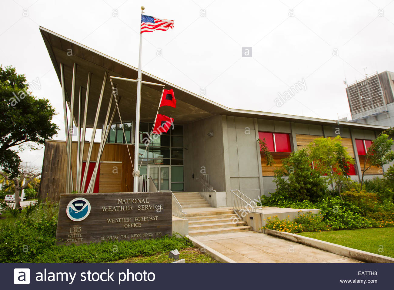
Interesting. Wonder what the elevation is of the NWS office. They can handle Cat 5 winds but what happens with storm surge?
They're in the highest bit (probably ~15ft), and their offices look to be raised a good a couple more feet beyond that: http://c8.alamy.com/comp/EATTH8/the-nat ... EATTH8.jpg
I'd imagine they'll do alright.
1 likes
-
Aric Dunn
- Category 5

- Posts: 21238
- Age: 43
- Joined: Sun Sep 19, 2004 9:58 pm
- Location: Ready for the Chase.
- Contact:
Re: ATL: IRMA - Hurricane - Discussion
if the last few frames on radar showing the outer eyewall closing off with deeper convection then thats no good.. once that inner eye stops "stealling" energy the outer eye can really intensify.
just have to wait some more..
just have to wait some more..
1 likes
Note: If I make a post that is brief. Please refer back to previous posts for the analysis or reasoning. I do not re-write/qoute what my initial post said each time.
If there is nothing before... then just ask
Space & Atmospheric Physicist, Embry-Riddle Aeronautical University,
I believe the sky is falling...
If there is nothing before... then just ask
Space & Atmospheric Physicist, Embry-Riddle Aeronautical University,
I believe the sky is falling...
-
Hurricaneman

- Category 5
- Posts: 7404
- Age: 45
- Joined: Tue Aug 31, 2004 3:24 pm
- Location: central florida
Re: ATL: IRMA - Hurricane - Discussion
Aric Dunn wrote:if the last few frames on radar showing the outer eyewall closing off with deeper convection then thats no good.. once that inner eye stops "stealling" energy the outer eye can really intensify.
just have to wait some more..
Looks as though the last 30min the inner eye seems to be starting to decay
1 likes
-
PandaCitrus
- Category 1

- Posts: 424
- Joined: Mon Sep 04, 2017 2:44 pm
Re: ATL: IRMA - Hurricane - Discussion
Look at the movement of the outer eyewall which is becoming more dominant. The inner eyewall is rotating around the outer eyewall and will eventually collapse. This is something that happens in eyewall replacement cycles. Irma is still working out the effects of the land interaction with Cuba.
2 likes
-
Emmett_Brown

- Category 5
- Posts: 1433
- Joined: Wed Aug 24, 2005 9:10 pm
- Location: Sarasota FL
Re: ATL: IRMA - Hurricane - Discussion
Last 3 recon fixes look as if the NW turn has begun, but radar definitely looks like a W wobble to my eyes as well. Perhaps the inner and outer eye walls are causing the dubious looking motion. Stepping back and looking at the IR loop, it appears that she is stair stepping WNW, and the overall cloud envelope looks like it is moving more NW than before.
1 likes
-
Kingarabian

- S2K Supporter
- Posts: 16351
- Joined: Sat Aug 08, 2009 3:06 am
- Location: Honolulu, Hawaii
Re: ATL: IRMA - Main Recon Thread (Data only)
URNT15 KWBC 092211
NOAA2 2711A IRMA HDOB 30 20170909
220130 2319N 07918W 6956 03046 9878 +116 +109 182064 065 058 005 00
220200 2319N 07916W 6957 03045 9880 +116 //// 171063 065 058 010 01
220230 2319N 07914W 6958 03048 9887 +114 //// 174062 063 053 010 01
220300 2319N 07912W 6957 03054 9893 +113 //// 178061 063 049 012 01
220330 2319N 07910W 6956 03062 9899 +111 //// 179075 083 047 014 01
220400 2319N 07908W 6959 03051 9892 +114 //// 183082 083 054 016 01
220430 2319N 07905W 6953 03066 9887 +123 +115 182078 080 055 013 00
220500 2319N 07903W 6948 03079 9905 +114 +113 177075 078 055 013 00
220530 2319N 07901W 6957 03070 9910 +114 +112 173074 077 054 014 03
220600 2319N 07859W 6957 03074 9921 +107 //// 170071 072 054 008 01
220630 2319N 07857W 6949 03088 9926 +106 //// 171073 073 051 010 01
220700 2319N 07855W 6957 03081 9926 +111 +105 170079 080 049 011 00
220730 2319N 07853W 6957 03083 9933 +109 +098 168077 079 047 010 00
220800 2319N 07851W 6958 03084 9936 +108 +099 166074 075 046 009 00
220830 2319N 07849W 6957 03089 9942 +108 +098 166071 072 045 008 00
220900 2319N 07847W 6958 03094 9942 +111 +094 163067 069 044 008 00
220930 2319N 07844W 6957 03097 9948 +109 +091 163064 065 044 005 00
221000 2319N 07842W 6961 03094 9956 +106 +090 165062 063 044 004 00
221030 2319N 07840W 6957 03103 9963 +102 +090 165058 060 045 005 00
221100 2319N 07838W 6957 03104 9967 +102 +086 165057 058 043 006 00
URNT15 KWBC 092221
NOAA2 2711A IRMA HDOB 31 20170909
221130 2319N 07836W 6962 03102 9966 +104 +088 164057 057 044 006 00
221200 2319N 07834W 6963 03105 9972 +102 +088 165063 064 042 005 00
221230 2319N 07832W 6954 03115 9975 +102 +085 164064 065 042 005 00
221300 2319N 07830W 6955 03116 9976 +103 +083 162063 064 040 004 00
221330 2319N 07828W 6955 03120 9980 +102 +084 161061 061 040 003 00
221400 2319N 07826W 6954 03123 9977 +107 +079 161062 063 040 003 00
221430 2319N 07824W 6957 03120 9983 +104 +076 163063 063 039 001 00
221500 2319N 07822W 6957 03123 9987 +104 +068 164065 065 037 002 00
221530 2319N 07820W 6954 03127 9987 +105 +065 163066 067 038 002 03
221600 2321N 07818W 6952 03130 9988 +105 +064 164067 067 035 003 03
221630 2323N 07817W 6953 03130 9993 +102 +064 165066 066 037 001 00
221700 2326N 07817W 6957 03124 9994 +100 +070 166065 066 038 001 00
221730 2328N 07817W 6957 03125 9991 +103 +069 166064 064 036 001 00
221800 2331N 07817W 6953 03131 9991 +102 +071 162064 065 036 001 00
221830 2334N 07817W 6955 03131 9998 +099 +070 160065 065 035 001 00
221900 2336N 07817W 6954 03133 9996 +101 +071 160063 065 035 001 00
221930 2339N 07817W 6957 03127 9992 +103 +071 159061 061 033 001 00
222000 2341N 07817W 6953 03135 9990 +106 +072 158061 061 033 001 00
222030 2344N 07817W 6955 03132 9989 +108 +067 158062 063 032 001 00
222100 2347N 07818W 6957 03131 9990 +108 +067 156064 064 031 001 00
0 likes
RIP Kobe Bryant
-
USTropics
- Professional-Met

- Posts: 2738
- Joined: Sun Aug 12, 2007 3:45 am
- Location: Florida State University
Re: ATL: IRMA - Hurricane - Discussion
It's most likely a trochoidal wobble due to the concentric eyewall.
3 likes
-
AdamFirst

- S2K Supporter
- Posts: 2490
- Age: 36
- Joined: Thu Aug 14, 2008 10:54 am
- Location: Port Saint Lucie, FL
Re: ATL: IRMA - Hurricane - Discussion
BULLETIN - EAS ACTIVATION REQUESTED
Tornado Warning
National Weather Service Miami FL
622 PM EDT SAT SEP 9 2017
The National Weather Service in Miami has issued a
* Tornado Warning for...
Northern Broward County in southeastern Florida...
Southwestern Palm Beach County in southeastern Florida...
* Until 700 PM EDT
* At 622 PM EDT, a severe thunderstorm capable of producing a tornado
was located near Coral Springs, moving west at 35 mph.
0 likes
Dolphins Marlins Canes Golden Panthers HEAT
Andrew 1992 - Irene 1999 - Frances 2004 - Jeanne 2004 - Wilma 2005 - Fay 2008 - Isaac 2012 - Matthew 2016 - Irma 2017 - Dorian 2019 - Ian 2022 - Nicole 2022 - Milton 2024
Andrew 1992 - Irene 1999 - Frances 2004 - Jeanne 2004 - Wilma 2005 - Fay 2008 - Isaac 2012 - Matthew 2016 - Irma 2017 - Dorian 2019 - Ian 2022 - Nicole 2022 - Milton 2024
-
tarheelprogrammer

- S2K Supporter
- Posts: 1793
- Joined: Mon Mar 28, 2016 9:25 pm
- Location: Raleigh, NC area (Garner, NC)
Re: ATL: IRMA - Hurricane - Discussion
It is not moving wsw, it is the inner eye wall rotating inside the outer eye wall. About to take off in the next 6 hours. I will pray for the Florida Keys that the idiots who stayed behind do not die. Also, praying for you guys in all of Florida. Be safe. 
3 likes
My posts are not official forecasts. They are just my opinion and may or may not be backed by sound meteorological data. They are NOT endorsed by any professional institution or storm2k.org. For official information, please refer to the NHC and NWS products.
-
Miami Storm Tracker

- Category 4

- Posts: 916
- Age: 68
- Joined: Sun Jun 13, 2010 10:12 pm
- Location: Key Largo, Fla.
- Contact:
Re: ATL: IRMA - Hurricane - Discussion
Yellowlab,
I can't explain it. I grew up in Key West and for what ever reason the locals never evacuate. I was young when Donna came in and what you see now is what you would have seen then. No different when Betsy came through, locals are just that way.
I can't explain it. I grew up in Key West and for what ever reason the locals never evacuate. I was young when Donna came in and what you see now is what you would have seen then. No different when Betsy came through, locals are just that way.
2 likes
Re: ATL: IRMA - Hurricane - Discussion
KBBOCA wrote:I've been following Miami met John Morales on Twitter since this was looking like a major impact for Miami.
Can anyone give recommendations of the best Twitter accounts / mets to follow for SW FL - Naples, Ft Myers, Tampa...
Check Paul Delagatto in Tampa. He's done a bang up job. Not sure if he does Twitter.
2 likes

Re: ATL: IRMA - Hurricane - Discussion
If you look at IR she's starting to get squished on the nw side. Not sure if that will effect strengthening trend or not, but while fired some good clouds today, it's looking a little warmer now
0 likes
-
jlauderdal
- S2K Supporter
- Posts: 7240
- Joined: Wed May 19, 2004 5:46 am
- Location: NE Fort Lauderdale
- Contact:
Re: RE: Re: ATL: IRMA - Hurricane - Discussion
Its the conch republic and they don't evacuate, more did this time than I can rememberMiami Storm Tracker wrote:Yellowlab,
I can't explain it. I grew up in Key West and for what ever reason the locals never evacuate. I was young when Donna came in and what you see now is what you would have seen then. No different when Betsy came through, locals are just that way.
Sent from my DL8006 using Tapatalk
2 likes
-
KBBOCA
- S2K Supporter
- Posts: 1559
- Joined: Fri Sep 05, 2003 5:27 am
- Location: Formerly Boca Raton, often West Africa. Currently Charlotte NC
Re: ATL: IRMA - Hurricane - Discussion
A simulation of winds in FL for the next 24 hours... JUST WOW
https://twitter.com/pcavlin/status/906584284324143105
https://twitter.com/pcavlin/status/906584284324143105
0 likes
-
Kingarabian
- S2K Supporter
- Posts: 16351
- Joined: Sat Aug 08, 2009 3:06 am
- Location: Honolulu, Hawaii
Re: ATL: IRMA - Main Recon Thread (Data only)
000
URNT15 KWBC 092231
NOAA2 2711A IRMA HDOB 32 20170909
222130 2349N 07818W 6954 03134 9990 +108 +066 155064 064 031 001 00
222200 2352N 07819W 6956 03132 9990 +108 +068 153065 066 031 001 00
222230 2354N 07820W 6955 03132 9992 +107 +066 152067 068 032 001 00
222300 2356N 07821W 6955 03132 9994 +104 +066 152070 070 034 001 00
222330 2359N 07823W 6956 03131 9994 +103 +067 151071 071 035 001 00
222400 2401N 07825W 6956 03129 9996 +101 +069 150071 071 037 001 00
222430 2403N 07826W 6954 03131 9998 +099 +069 149068 069 035 002 00
222500 2405N 07828W 6956 03129 9993 +103 +068 148069 069 035 001 00
222530 2408N 07829W 6953 03131 9990 +104 +072 152068 069 035 002 00
222600 2410N 07831W 6955 03130 9993 +102 +072 151068 069 035 001 00
222630 2412N 07832W 6955 03130 9995 +100 +073 149067 068 034 002 00
222700 2415N 07833W 6956 03129 9995 +100 +073 150067 068 035 002 00
222730 2417N 07835W 6956 03128 9994 +101 +072 149069 069 036 001 00
222800 2419N 07837W 6954 03130 9996 +098 +074 147069 069 035 002 00
222830 2421N 07839W 6955 03130 9998 +098 +075 145068 068 037 001 00
222900 2424N 07840W 6955 03138 0001 +100 +072 145067 068 037 002 03
222930 2426N 07842W 6956 03138 0005 +100 +073 144067 068 038 001 03
223000 2428N 07844W 6953 03140 0002 +102 +069 142068 068 035 001 00
223030 2430N 07846W 6957 03135 0004 +099 +074 142070 071 035 001 00
223100 2432N 07847W 6956 03135 0002 +100 +075 143072 073 035 001 00
0 likes
RIP Kobe Bryant
-
GBPackMan
Re: ATL: IRMA - Hurricane - Discussion
We have seen the Euro consistently track south and west of the actual track, the GFS consistently track north and east, and the real track has been somewhere inbetween... Yes closer to Euro but it has consistently been south and east almost the entire time. This is nature and it can do things outside of predictability but you cannot really look at one SW wobble over a 2hour span as a massive western swing towards the panhandle, just as a stall does not mean an early track to head directly for Miami.
This is still a MASSIVE storm and all we can hope for at this point is a SW FL landfall so by the time it gets to the middle of the state much of the strength is gone making it not as bad for the rest of the state... versus a continued western track staying just offshore until Tampa means continued intensification and that much more damage throughout the entire state including the panhandle.
This is still a MASSIVE storm and all we can hope for at this point is a SW FL landfall so by the time it gets to the middle of the state much of the strength is gone making it not as bad for the rest of the state... versus a continued western track staying just offshore until Tampa means continued intensification and that much more damage throughout the entire state including the panhandle.
0 likes
Re: ATL: IRMA - Hurricane - Discussion
Miami Storm Tracker wrote:Yellowlab,
I can't explain it. I grew up in Key West and for what ever reason the locals never evacuate. I was young when Donna came in and what you see now is what you would have seen then. No different when Betsy came through, locals are just that way.
Anybody know what the highest surge is on record for key west? Is it location and topography that make getting higher than 10 on key west difficult? I did some research and all I can find is 1846 storm that cleaned most of the island and residents fled to Solaris hill, and that says 8 ft. But I think Wilma was 8 feet, and they are saying 5-10 with this one. Not sure what Betsy was. I will say Wilma wouldn't have had as much battering waves as a storm like this. That may surprise residents who flooded in Wilma but may come back to a foundation.
0 likes
-
forecasterjack
- Tropical Storm

- Posts: 195
- Joined: Wed Aug 23, 2017 3:44 pm
Re: ATL: IRMA - Hurricane - Discussion
Eye continuing to warm as outer eyewall tries to assert its dominance. Notice warming in the E of the inner eyewall. 1 min IR: https://weather.us/satellite/812-w-236-n/top-alert-superhd-1min.html#play
0 likes
Who is online
Users browsing this forum: No registered users and 315 guests