Big Pine Key & Cudjoe Key sont à présent dans l'oeil d'#Irma qui poursuit sa route vers le nord/nord-ouest. #Floride
Big Pine Key & Cudjoe Key are now in the eye of #Irma which proceeds to the North/Northwest. #Floride

Moderator: S2k Moderators


xtyphooncyclonex wrote:what time would the landfall declaration be over Big Pine Key??
Michele B wrote:KBBOCA wrote:Dave EpsteinVerified account @growingwisdom 10m10 minutes ago
About 1/2 of Miami-Dade county now without power.
Is there a link for this site?
gatorcane wrote:Sure looks NNE to me. Reminds me of Charley which took a more NNE track instead of N. Most models thought north.
gatorcane wrote:Sure looks NNE to me. Reminds me of Charley which took a more NNE track instead of N. Most models thought north.


John also said the hurricane is overperforming due to the jog eastKBBOCA wrote:Conditions in Kendall:
John MoralesVerified account @JohnMoralesNBC6 2m2 minutes ago
Gusting to 70 MPH. Will get worse
Also per John Morales a few minutes ago: 100 MPH gusts likely now for Miami high-rise buildings.

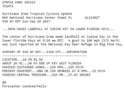
1900hurricane wrote:xtyphooncyclonex wrote:what time would the landfall declaration be over Big Pine Key??ZCZC MIATCUAT1 ALL
TTAA00 KNHC DDHHMM
Hurricane Irma Tropical Cyclone Update
NWS National Hurricane Center Miami FL AL112017
910 AM EDT Sun Sep 10 2017
...IRMA MAKES LANDFALL AT CUDJOE KEY IN LOWER FLORIDA KEYS...
The center of Hurricane Irma made landfall at Cudjoe Key in the
lower Florida Keys at 9:10 am EDT. A gust to 106 mph (171 km/h)
was just reported at the National Key Deer Refuge in Big Pine Key.
SUMMARY OF 910 AM EDT...1310 UTC...INFORMATION
----------------------------------------------
LOCATION...24.7N 81.5W
ABOUT 20 MI...30 KM ENE OF KEY WEST FLORIDA
MAXIMUM SUSTAINED WINDS...130 MPH...215 KM/H
PRESENT MOVEMENT...NNW OR 330 DEGREES AT 8 MPH...13 KM/H
MINIMUM CENTRAL PRESSURE...929 MB...27.43 INCHES
$$
Forecaster Landsea/Mello
NNNN

AdamFirst wrote:ronjon wrote:Eye appears to be tightening on radar with convection starting to wrapping around southern eyewall. She may be strengthening.
The last hurrah...Irma giving us one last "#@$% you" before landfall.
If that is the case, then I hope for landfall over Cape Sable and mainland Monroe, to keep the intense eyewall over relatively unpopulated areas & the Everglades.
Users browsing this forum: No registered users and 14 guests

