ATL: IRMA - Post-Tropical - Discussion
Moderator: S2k Moderators
-
tolakram
- Admin

- Posts: 20179
- Age: 62
- Joined: Sun Aug 27, 2006 8:23 pm
- Location: Florence, KY (name is Mark)
Re: ATL: IRMA - Hurricane - Discussion
Also HurricaneTrack marco Island cam: http://www.ustream.tv/channel/hurricane ... -surge-cam
1 likes
M a r k
- - - - -
Join us in chat: Storm2K Chatroom Invite. Android and IOS apps also available.
The posts in this forum are NOT official forecasts and should not be used as such. Posts are NOT endorsed by any professional institution or STORM2K.org. For official information and forecasts, please refer to NHC and NWS products.
-
KBBOCA
- S2K Supporter

- Posts: 1559
- Joined: Fri Sep 05, 2003 5:27 am
- Location: Formerly Boca Raton, often West Africa. Currently Charlotte NC
Re: ATL: IRMA - Hurricane - Discussion
Rick Luettich @RLuettich
The maximum storm surge + waves in Naples will be ~ 2-3 hrs after eye. Combination can be devastating. #Irma
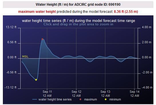
https://twitter.com/RLuettich/status/906896240205582336
The maximum storm surge + waves in Naples will be ~ 2-3 hrs after eye. Combination can be devastating. #Irma
https://twitter.com/RLuettich/status/906896240205582336
0 likes
-
Sciencerocks
- Category 5

- Posts: 10181
- Age: 40
- Joined: Thu Jul 06, 2017 1:51 am
Re: ATL: IRMA - Main Recon Thread (Data only)
000
URNT15 KNHC 101512
AF306 3011A IRMA HDOB 35 20170910
150300 2454N 08128W 6968 02642 9427 +147 +138 231085 096 073 003 00
150330 2455N 08129W 6970 02615 9395 +148 +144 233071 078 062 004 03
150400 2456N 08130W 6968 02598 9365 +163 +137 233053 066 028 002 00
150430 2458N 08132W 6971 02586 9353 +167 +136 232031 044 011 002 03
150500 2459N 08133W 6974 02582 9355 +163 +140 239016 026 010 002 00
150530 2500N 08134W 6963 02591 9357 +155 +146 281010 011 010 001 03
150600 2502N 08135W 6964 02587 9352 +158 +146 301004 009 010 001 03
150630 2504N 08136W 6967 02580 9342 +166 +145 050003 005 009 001 03
150700 2505N 08136W 6963 02582 9330 +178 +134 070016 021 006 001 03
150730 2507N 08138W 6971 02580 9330 +187 +131 064034 040 025 001 00
150800 2508N 08139W 6967 02600 9346 +189 +132 062050 055 039 003 00
150830 2509N 08141W 6977 02606 9382 +173 +144 057064 071 040 004 03
150900 2511N 08142W 6968 02639 9441 +149 //// 058083 087 092 037 01
150930 2512N 08143W 6961 02677 9472 +144 //// 063095 097 094 038 05
151000 2513N 08145W 6970 02727 9533 +143 +143 066092 097 079 041 03
151030 2515N 08147W 6974 02751 9572 +138 +135 061087 092 077 023 03
151100 2516N 08148W 6964 02784 9583 +142 +129 061083 088 071 013 00
151130 2517N 08149W 6953 02821 9639 +129 +129 065086 089 064 010 00
151200 2519N 08151W 6976 02817 9648 +128 +122 065078 083 059 007 00
151230 2520N 08153W 6967 02843 9652 +141 +093 063071 072 055 005 00
$$
;
0 likes
-
TheStormExpert

-
AutoPenalti
- Category 5
- Posts: 4091
- Age: 29
- Joined: Mon Aug 17, 2015 4:16 pm
- Location: Ft. Lauderdale, Florida
Re: ATL: IRMA - Hurricane - Discussion
NDG wrote:Wilma's pressure is rising.
150700 2505N 08136W 6963 02582 9330 +178 +134 070016 021 006 001 03
150730 2507N 08138W 6971 02580 9330 +187 +131 064034 040 025 001 00
I think NDG is stuck in 2005
5 likes
The posts in this forum are NOT official forecasts and should not be used as such. They are just the opinion of the poster and may or may not be backed by sound meteorological data. They are NOT endorsed by any professional institution or STORM2K. For official information, please refer to products from the NHC and NWS.
Model Runs Cheat Sheet:
GFS (5:30 AM/PM, 11:30 AM/PM)
HWRF, GFDL, UKMET, NAVGEM (6:30-8:00 AM/PM, 12:30-2:00 AM/PM)
ECMWF (1:45 AM/PM)
TCVN is a weighted averaged
Re: ATL: IRMA - Hurricane - Discussion
decgirl66 wrote:This is what happens when you're not familiar with hurricanes.
Also - and I think this is going to become my PERSONAL CAMPAIGN....the "line" that shows the track of the hurricane should be waaay THICKER. The "cone" does not show people how large a storm is. It just says, "Might come in somewhere in the cone...."
But the "line" makes people complacent. They see the "line" waaay over on top of I-75, or 41, so they think that's the only place where effects will be felt. That needs to change to educate people better.
Agreed! Also, a lot of people don't understand that "landfall" means where the eye comes on shore.[/quote]
That's right. Again, a misconception that "landfall" means the storm suddenly APPEARS! Not that it builds up to that landfalling moment for several hours.
0 likes
Cleo - 1964, Betsy - 1965, David - 1979, Andrew - 1992, Charlie (Francis, Ivan, Jeanne) - 2004, Irma - 2017, Ian - 2022, Milton - 2024
-
KBBOCA
- S2K Supporter
- Posts: 1559
- Joined: Fri Sep 05, 2003 5:27 am
- Location: Formerly Boca Raton, often West Africa. Currently Charlotte NC
Re: ATL: IRMA - Hurricane - Discussion
Tampa surge may not be major according to Tampa met Paul Dellegatto:
Paul Dellegatto⚡️FOXVerified account @PaulFox13 11m11 minutes ago
[responding to a pic of water being pushed out of Tampa Bay...]
Talked about this yesterday. Strong east winds drain the bay. Water does not come back until Irma north of us. Not a setup for major surge.
Paul Dellegatto⚡️FOXVerified account @PaulFox13 11m11 minutes ago
[responding to a pic of water being pushed out of Tampa Bay...]
Talked about this yesterday. Strong east winds drain the bay. Water does not come back until Irma north of us. Not a setup for major surge.
1 likes
-
CaptinCrunch

- S2K Supporter
- Posts: 8778
- Age: 58
- Joined: Mon Nov 03, 2003 4:33 pm
- Location: Kennedale, TX (Tarrant Co.)
Re: ATL: IRMA - Hurricane - Discussion
Official report from Miami International Airport of 94mph wind gust.
1 likes

Re: ATL: IRMA - Hurricane - Discussion
I usually watch Brett and Brandon, but they are several live streamers via https://livestormchasing.com/map
0 likes
-
KBBOCA
- S2K Supporter
- Posts: 1559
- Joined: Fri Sep 05, 2003 5:27 am
- Location: Formerly Boca Raton, often West Africa. Currently Charlotte NC
Re: ATL: IRMA - Hurricane - Discussion
NWS MiamiVerified account @NWSMiami 11m11 minutes ago
11:04 AM: Eye of #Irma heading towards the SW #Florida coast. Everyone needs to remain sheltered in place.
https://twitter.com/NWSMiami/status/906897125728014336
11:04 AM: Eye of #Irma heading towards the SW #Florida coast. Everyone needs to remain sheltered in place.
https://twitter.com/NWSMiami/status/906897125728014336
0 likes
-
johngaltfla

- Category 5
- Posts: 2073
- Joined: Sun Jul 10, 2005 9:17 pm
- Location: Sarasota County, FL
- Contact:
Re: ATL: IRMA - Hurricane - Discussion
northjaxpro wrote:Just got a wind gust to 41 mph in the past few minutes. Tropical storm wind gusts have begun here already.
I have received 5.5 inches of rainfall so far just with the present nor'easter ahead of Irma.
Irma's outer rain bands have yet to impact Northeast Florida. That will be later today into tonight. Expecting another 6-8 inches of rain when Irma finally Gogh finished her nasty trek here and gets out of here by Tuesday morning, on top of what I have already received.
We're getting some TS level gusts which is good as it knocks the dead oak branches off of the tree before the big winds get here.
0 likes

Re: ATL: IRMA - Hurricane - Discussion
If she can go ahead and get her butt onshore at Marco island that will really be like a best case scenario. The most obscene surge will be in the Everglades and that eastern eye won't scrape every city on the coast. I would think some surge will still occur north of land fall but it would far less than paralleling the coast
2 likes
-
Blown Away

- S2K Supporter
- Posts: 10253
- Joined: Wed May 26, 2004 6:17 am
Re: ATL: IRMA - Hurricane - Discussion
TheStormExpert wrote:StormingB81 wrote:MrJames wrote:
They going to stick with it..probably just saw it was still in the cone if it doesnt get back on track ...
This track just shows how much faith they have lost for the GFS.

Radar says near due N, GFS says E of track, Irma is E of the 00z Euro, and still the NHC wants to lean Euro NW... We sure have learned NHC when it's crunch time will go all in Euro...
3 likes
Hurricane Eye Experience: David 79, Irene 99, Frances 04, Jeanne 04, Wilma 05… Hurricane Brush Experience: Andrew 92, Erin 95, Floyd 99, Matthew 16, Irma 17, Ian 22, Nicole 22…
-
La Sirena

- Category 1

- Posts: 308
- Joined: Sun Aug 21, 2016 4:02 pm
- Location: Formerly of the Keys, back home in East TN
Re: ATL: IRMA - Hurricane - Discussion
northjaxpro wrote:Just got a wind gust to 41 mph in the past few minutes. Tropical storm wind gusts have begun here already.
I have received 5.5 inches of rainfall so far just with the present nor'easter ahead of Irma.
Irma's outer rain bands have yet to impact Northeast Florida. That will be later today into tonight. Expecting another 6-8 inches of rain when Irma finally Gogh finished her nasty trek here and gets out of here by Tuesday morning, on top of what I have already received.
It's very gusty here in southeast Alabama and anticipated to get worse. They're putting a 4 pm curfew on the roads here in Dothan and we've been informed that even the police won't be out. Just crazy.
1 likes
The posts in this forum are NOT official forecasts and should not be used as such. They are just the opinion of the poster and may or may not be backed by sound meteorological data. They are NOT endorsed by any professional institution or STORM2K. For official information, please refer to products from the NHC and NWS.
Hurricane Irma,Hurricane Michael, Hurricane Helene
-
KBBOCA
- S2K Supporter
- Posts: 1559
- Joined: Fri Sep 05, 2003 5:27 am
- Location: Formerly Boca Raton, often West Africa. Currently Charlotte NC
Re: ATL: IRMA - Hurricane - Discussion
NHC Atlantic OpsVerified account @NHC_Atlantic 11m11 minutes ago
Here are the Key Messages for #Irma advisory 46.
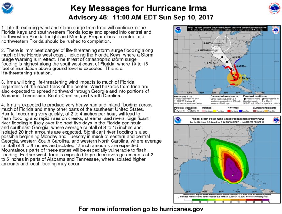
Here are the Key Messages for #Irma advisory 46.
0 likes
Re: ATL: IRMA - Hurricane - Discussion
PandaCitrus wrote:It'll be interesting to see what Irma does as she approaches Marco Island. If the pattern of Cuba holds, she will feel the friction of land, slow down a little, and then bounce around Marco and hug the coast of Naples going NNW for a bit.
Charley also did this and bounced around Captiva.
Yeah, she doesn't like land, that's for sure!
But how long can she fight the effects of the trough trying to pull her eastward?
I'm gonna sounds NUTS here, but it's almost like she KNOWS if she goes inland, she dies. Like a survival instinct.
1 likes
Cleo - 1964, Betsy - 1965, David - 1979, Andrew - 1992, Charlie (Francis, Ivan, Jeanne) - 2004, Irma - 2017, Ian - 2022, Milton - 2024
-
KBBOCA
- S2K Supporter
- Posts: 1559
- Joined: Fri Sep 05, 2003 5:27 am
- Location: Formerly Boca Raton, often West Africa. Currently Charlotte NC
Re: ATL: IRMA - Hurricane - Discussion
Philip KlotzbachVerified account @philklotzbach 11m11 minutes ago
Here's a brief recap of some of #Irma's most notable meteorological records, valid as of 11am EDT.
https://webcms.colostate.edu/tropical/m ... ecords.pdf
Here's a brief recap of some of #Irma's most notable meteorological records, valid as of 11am EDT.
https://webcms.colostate.edu/tropical/m ... ecords.pdf
0 likes

Re: ATL: IRMA - Hurricane - Discussion
northjaxpro wrote:Just got a wind gust to 41 mph in the past few minutes. Tropical storm wind gusts have begun here already.
I have received 5.5 inches of rainfall so far just with the present nor'easter ahead of Irma.
Irma's outer rain bands have yet to impact Northeast Florida. That will be later today into tonight. Expecting another 6-8 inches of rain when Irma finally Gogh finished her nasty trek here and gets out of here by Tuesday morning, on top of what I have already received.
Saint Augustine is already getting storm surge just from the Nor'easter, I think storm surge up here could rival Matthew. Lots of people disregarded evac orders on the beaches hopefully seeing storm surge before we are even seeing Irma changes their minds.
1 likes
Re: ATL: IRMA - Hurricane - Discussion
gatorcane wrote:Does anybody have a graphic of how far it has deviated from projected track?
Which one?
0 likes
Cleo - 1964, Betsy - 1965, David - 1979, Andrew - 1992, Charlie (Francis, Ivan, Jeanne) - 2004, Irma - 2017, Ian - 2022, Milton - 2024
-
KBBOCA
- S2K Supporter
- Posts: 1559
- Joined: Fri Sep 05, 2003 5:27 am
- Location: Formerly Boca Raton, often West Africa. Currently Charlotte NC
Re: ATL: IRMA - Hurricane - Discussion
THis is the clearest picture yet I've seen of all the water gone from Tampa Bay:
[video]
https://twitter.com/KeraunosObs/status/906897911589588994
[video]
https://twitter.com/KeraunosObs/status/906897911589588994
2 likes
Who is online
Users browsing this forum: No registered users and 34 guests