ATL: IRMA - Post-Tropical - Discussion
Moderator: S2k Moderators
Re: ATL: IRMA - Hurricane - Discussion
Reports sea has pushed out of San Carlos Bay Sanibel...Bay is dry land...
1 likes
-
tolakram
- Admin

- Posts: 20179
- Age: 62
- Joined: Sun Aug 27, 2006 8:23 pm
- Location: Florence, KY (name is Mark)
Re: ATL: IRMA - Hurricane - Discussion
Not funny. Un-doctored satellite image.

source: http://weather.cod.edu/satrad/exper/?parms=meso1-13-96-1-10
source: http://weather.cod.edu/satrad/exper/?parms=meso1-13-96-1-10
9 likes
M a r k
- - - - -
Join us in chat: Storm2K Chatroom Invite. Android and IOS apps also available.
The posts in this forum are NOT official forecasts and should not be used as such. Posts are NOT endorsed by any professional institution or STORM2K.org. For official information and forecasts, please refer to NHC and NWS products.
-
KBBOCA
- S2K Supporter

- Posts: 1559
- Joined: Fri Sep 05, 2003 5:27 am
- Location: Formerly Boca Raton, often West Africa. Currently Charlotte NC
Re: ATL: IRMA - Hurricane - Discussion
NWS MelbourneVerified account @NWSMelbourne 5m5 minutes ago
Risk of flooding will continue as strong rain bands move through our area. Do not drive through flooded roadways! TURN AROUND, DON'T DROWN!
Risk of flooding will continue as strong rain bands move through our area. Do not drive through flooded roadways! TURN AROUND, DON'T DROWN!
1 likes

Re: ATL: IRMA - Hurricane - Discussion
Cincinnati wrote:jasons wrote:109mph gust in Broward.
Source?
The Weather Channel just reported that at an airpot
0 likes
Alicia, Rita, Ike, Harvey and Beryl...moved to Splendora lol
-
KBBOCA
- S2K Supporter
- Posts: 1559
- Joined: Fri Sep 05, 2003 5:27 am
- Location: Formerly Boca Raton, often West Africa. Currently Charlotte NC
Re: ATL: IRMA - Hurricane - Discussion
Michael Watkins @watkinstrack 2m2 minutes ago
Michael Watkins Retweeted bnorcross
Stay put, tail could be as strong as any part of the storm here on the FL EC, and could put down a TON of rain in a short time in some spots.
Michael Watkins Retweeted bnorcross
Stay put, tail could be as strong as any part of the storm here on the FL EC, and could put down a TON of rain in a short time in some spots.
1 likes
-
tolakram
- Admin
- Posts: 20179
- Age: 62
- Joined: Sun Aug 27, 2006 8:23 pm
- Location: Florence, KY (name is Mark)
Re: ATL: IRMA - Hurricane - Discussion
0 likes
M a r k
- - - - -
Join us in chat: Storm2K Chatroom Invite. Android and IOS apps also available.
The posts in this forum are NOT official forecasts and should not be used as such. Posts are NOT endorsed by any professional institution or STORM2K.org. For official information and forecasts, please refer to NHC and NWS products.
- - - - -
Join us in chat: Storm2K Chatroom Invite. Android and IOS apps also available.
The posts in this forum are NOT official forecasts and should not be used as such. Posts are NOT endorsed by any professional institution or STORM2K.org. For official information and forecasts, please refer to NHC and NWS products.
-
Sciencerocks
- Category 5

- Posts: 10181
- Age: 40
- Joined: Thu Jul 06, 2017 1:51 am
Re: ATL: IRMA - Main Recon Thread (Data only)
000
URNT15 KNHC 101612
AF306 3011A IRMA HDOB 41 20170910
160300 2535N 08335W 6967 03065 9944 +096 +093 020043 044 /// /// 03
160330 2535N 08335W 6967 03065 9942 +097 +093 018044 046 /// /// 03
160400 2531N 08335W 6965 03067 9941 +097 +092 014045 046 060 000 03
160430 2528N 08335W 6969 03060 9938 +099 +092 012046 046 061 000 03
160500 2526N 08335W 6966 03064 9938 +100 +091 008046 046 061 000 00
160530 2524N 08335W 6966 03063 9937 +097 +093 005046 047 060 000 03
160600 2522N 08335W 6966 03060 9939 +095 +093 004047 047 058 000 01
160630 2520N 08335W 6965 03062 9937 +095 +094 001047 047 058 000 05
160700 2517N 08335W 6968 03058 9933 +100 +093 359048 048 056 000 03
160730 2515N 08335W 6966 03060 9933 +097 +094 359048 049 055 000 03
160800 2513N 08335W 6968 03058 9934 +096 +094 359047 048 052 000 05
160830 2511N 08335W 6968 03058 9934 +098 +095 359047 048 051 001 03
160900 2509N 08335W 6963 03063 9935 +097 +094 355047 048 051 000 03
160930 2507N 08335W 6967 03057 9932 +096 +095 354047 048 051 000 01
161000 2504N 08335W 6970 03052 9933 +095 +093 354046 048 050 000 01
161030 2502N 08335W 6965 03057 9933 +095 +092 354047 047 051 000 00
161100 2500N 08335W 6966 03053 9932 +095 +091 354048 049 049 000 00
161130 2458N 08335W 6970 03046 9922 +102 +089 349050 051 049 000 03
161200 2456N 08335W 6963 03054 9914 +108 +083 348051 052 050 001 00
161230 2453N 08335W 6967 03048 9911 +110 +083 346053 053 050 000 00
$$
0 likes

Re: ATL: IRMA - Hurricane - Discussion
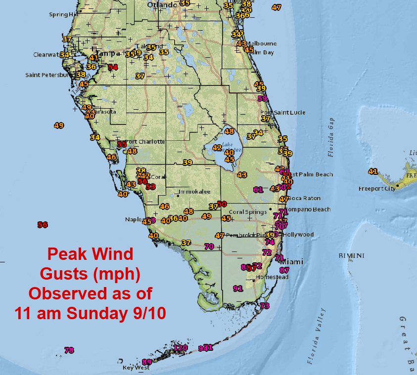
KBBOCA wrote:NWS Eastern RegionVerified account @NWSEastern 3m3 minutes ago
Here are some of the peak wind gust observations, observed rainfall, and forecast additional rainfall from #Irma as of 11 am EDT Sunday.
https://pbs.twimg.com/media/DJX48LtVYAMFJUk.jpg
https://twitter.com/NWSEastern/status/906904708111060992
This should also say that these were peak winds before some of the stations' instruments failed or stopped reporting.
2 likes
-
Sciencerocks
- Category 5
- Posts: 10181
- Age: 40
- Joined: Thu Jul 06, 2017 1:51 am
Re: ATL: IRMA - Main Recon Thread (Data only)
000
URNT15 KNHC 101622
AF306 3011A IRMA HDOB 42 20170910
161300 2451N 08335W 6967 03048 9914 +108 +085 346054 054 048 001 00
161330 2449N 08335W 6963 03054 9914 +107 +083 346054 054 046 000 00
161400 2447N 08335W 6969 03048 9915 +110 +079 345055 055 046 000 00
161430 2445N 08335W 6966 03051 9914 +110 +079 346054 055 045 000 03
161500 2442N 08335W 6968 03049 9916 +108 +082 343050 054 045 001 00
161530 2440N 08335W 6969 03046 9918 +104 +084 340050 050 046 001 00
161600 2438N 08335W 6967 03049 9919 +104 +085 338050 051 043 001 00
161630 2436N 08335W 6967 03048 9916 +106 +085 337049 051 043 000 00
161700 2434N 08335W 6969 03047 9919 +106 +085 334049 049 042 001 00
161730 2432N 08335W 6965 03059 9924 +108 +073 333053 054 041 001 00
161800 2429N 08335W 6966 03060 9925 +110 +070 332055 056 042 001 03
161830 2427N 08335W 6967 03061 9924 +112 +061 330057 058 041 001 00
161900 2425N 08335W 6964 03066 9924 +115 +056 331060 061 041 001 00
161930 2423N 08335W 6970 03061 9926 +115 +055 331061 062 040 000 00
162000 2421N 08335W 6968 03065 9929 +115 +053 329062 062 040 001 00
162030 2418N 08335W 6965 03071 9932 +115 +052 327060 062 039 001 00
162100 2416N 08335W 6967 03069 9931 +115 +060 323057 059 038 001 00
162130 2414N 08335W 6966 03072 9932 +115 +062 323055 056 038 000 03
162200 2412N 08335W 6964 03075 9936 +113 +061 324056 056 037 001 00
162230 2410N 08335W 6965 03075 9940 +110 +062 323055 057 038 000 00
$$
;
0 likes
-
stormreader
Re: ATL: IRMA - Hurricane - Discussion
tolakram wrote:Not funny. Un-doctored satellite image.
source: http://weather.cod.edu/satrad/exper/?parms=meso1-13-96-1-10
Thanks for the info to those who responded to my speculation about Irma getting stronger. You are probably right. But this sat image and what I have seen on NHC site, looks like much deeper reds in the eyewall area. Lots of innate energy in this storm will be released as the NE quadrant impacts land at Naples.
0 likes
Re: ATL: IRMA - Hurricane - Discussion
109mph wind gust in Broward County was reported at Pembroke Pines Middle School per NBC 6 news here. They have an anemometer at the school.
Last edited by JPmia on Sun Sep 10, 2017 11:30 am, edited 1 time in total.
1 likes
-
JarrodB
Re: ATL: IRMA - Hurricane - Discussion
We are getting. 48 mph gusts in St. Augustine, have been for hours. I took a walk up to the Bridge of Lions and water is coming over the sea wall. Probably 3 to 4' of surge here already.
2 likes
-
tolakram
- Admin
- Posts: 20179
- Age: 62
- Joined: Sun Aug 27, 2006 8:23 pm
- Location: Florence, KY (name is Mark)
Re: ATL: IRMA - Hurricane - Discussion
GIF of wind gusts from the 12Z GFS

1 likes
M a r k
- - - - -
Join us in chat: Storm2K Chatroom Invite. Android and IOS apps also available.
The posts in this forum are NOT official forecasts and should not be used as such. Posts are NOT endorsed by any professional institution or STORM2K.org. For official information and forecasts, please refer to NHC and NWS products.
- - - - -
Join us in chat: Storm2K Chatroom Invite. Android and IOS apps also available.
The posts in this forum are NOT official forecasts and should not be used as such. Posts are NOT endorsed by any professional institution or STORM2K.org. For official information and forecasts, please refer to NHC and NWS products.
-
Hurricane Andrew

- S2K Supporter
- Posts: 1891
- Age: 27
- Joined: Sun May 23, 2010 2:53 pm
- Location: KS
Re: ATL: IRMA - Hurricane - Discussion
I inow we have a few members here who live in Orlando...whats it like down there right now?
0 likes
The Enthusiast
NREMT-AEMT, WX nerd
Irene '11, Sandy '12, Irma '17 (SAR)
"Hard to think we were born to live this way..." -Wage War
-
KBBOCA
- S2K Supporter
- Posts: 1559
- Joined: Fri Sep 05, 2003 5:27 am
- Location: Formerly Boca Raton, often West Africa. Currently Charlotte NC
Re: ATL: IRMA - Hurricane - Discussion
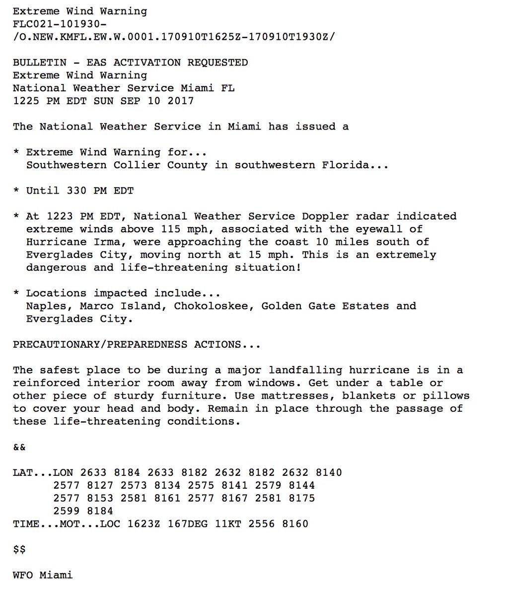
EXTREME WIND WARNING - SW Collier County (Marco Island, Naples, etc...)
https://twitter.com/NHC_Atlantic/status ... 2908988417
NHC Atlantic OpsVerified account @NHC_Atlantic 3m3 minutes ago
Extreme Wind Warning issued for SW Collier County FL for winds in the eyewall of #Irma @NWSMiami
https://twitter.com/NHC_Atlantic/status ... 2908988417
NHC Atlantic OpsVerified account @NHC_Atlantic 3m3 minutes ago
Extreme Wind Warning issued for SW Collier County FL for winds in the eyewall of #Irma @NWSMiami
0 likes
-
Bocadude85

- Category 5
- Posts: 2991
- Age: 39
- Joined: Mon Apr 18, 2005 2:20 pm
- Location: Honolulu,Hi
Re: ATL: IRMA - Hurricane - Discussion
Extreme Wind Warning
FLC021-101930-
/O.NEW.KMFL.EW.W.0001.170910T1625Z-170910T1930Z/
BULLETIN - EAS ACTIVATION REQUESTED
Extreme Wind Warning
National Weather Service Miami FL
1225 PM EDT SUN SEP 10 2017
The National Weather Service in Miami has issued a
* Extreme Wind Warning for...
Southwestern Collier County in southwestern Florida...
* Until 330 PM EDT
* At 1223 PM EDT, National Weather Service Doppler radar indicated
extreme winds above 115 mph, associated with the eyewall of
Hurricane Irma, were approaching the coast 10 miles south of
Everglades City, moving north at 15 mph. This is an extremely
dangerous and life-threatening situation!
* Locations impacted include...
Naples, Marco Island, Chokoloskee, Golden Gate Estates and
Everglades City.
PRECAUTIONARY/PREPAREDNESS ACTIONS...
The safest place to be during a major landfalling hurricane is in a
reinforced interior room away from windows. Get under a table or
other piece of sturdy furniture. Use mattresses, blankets or pillows
to cover your head and body. Remain in place through the passage of
these life-threatening conditions.
&&
LAT...LON 2633 8184 2633 8182 2632 8182 2632 8140
2577 8127 2573 8134 2575 8141 2579 8144
2577 8153 2581 8161 2577 8167 2581 8175
2599 8184
TIME...MOT...LOC 1623Z 167DEG 11KT 2556 8160
$$
WFO Miami
0 likes
-
KBBOCA
- S2K Supporter
- Posts: 1559
- Joined: Fri Sep 05, 2003 5:27 am
- Location: Formerly Boca Raton, often West Africa. Currently Charlotte NC
Re: ATL: IRMA - Hurricane - Discussion
Chris Marciano @diabaticpv 12m12 minutes ago
Outflow jet strengthening over last hr as #Irma's outflow feeds downstream ridge. Will aid mass evac & allow precip shield to expand over SE
https://twitter.com/diabaticpv/status/906915978210107392
Outflow jet strengthening over last hr as #Irma's outflow feeds downstream ridge. Will aid mass evac & allow precip shield to expand over SE
https://twitter.com/diabaticpv/status/906915978210107392
1 likes
-
Sciencerocks
- Category 5
- Posts: 10181
- Age: 40
- Joined: Thu Jul 06, 2017 1:51 am
Re: ATL: IRMA - Main Recon Thread (Data only)
000
URNT15 KNHC 101632
AF306 3011A IRMA HDOB 43 20170910
162300 2408N 08335W 6967 03074 9941 +111 +061 323053 054 037 001 00
162330 2406N 08335W 6971 03070 9943 +111 +059 323052 053 037 001 00
162400 2403N 08335W 6966 03080 9943 +111 +065 320050 051 038 002 00
162430 2401N 08335W 6967 03077 9949 +107 +068 322051 052 037 001 03
162500 2359N 08335W 6967 03080 9948 +110 +060 321055 055 039 000 03
162530 2357N 08335W 6968 03080 9952 +107 +062 322054 055 037 000 00
162600 2355N 08335W 6963 03087 9958 +104 +061 321055 055 037 001 00
162630 2353N 08335W 6968 03082 9960 +105 +059 318054 055 037 000 03
162700 2351N 08335W 6967 03086 9963 +102 +060 317053 053 037 000 03
162730 2349N 08335W 6969 03084 9964 +102 +060 317052 053 036 000 03
162800 2347N 08335W 6967 03088 9969 +100 +069 317051 053 037 000 03
162830 2345N 08336W 6971 03083 9966 +103 +073 316047 050 043 002 03
162900 2343N 08336W 6967 03092 9967 +105 +063 313049 050 040 000 03
162930 2341N 08335W 6967 03090 9972 +100 +064 314049 049 040 000 00
163000 2339N 08335W 6964 03093 9974 +098 +069 313047 048 038 000 03
163030 2338N 08333W 6967 03090 9974 +098 +069 311045 047 /// /// 03
163100 2339N 08332W 6970 03086 9972 +100 +066 311043 043 041 000 00
163130 2341N 08331W 6967 03089 9965 +104 +064 310043 044 041 000 03
163200 2342N 08329W 6969 03087 9964 +105 +064 309046 047 045 000 03
163230 2343N 08328W 6967 03088 9967 +100 +069 314048 049 044 000 03
$$
;
0 likes
Re: ATL: IRMA - Hurricane - Discussion
tolakram wrote:GIF of wind gusts from the 12Z GFS
Well the GFS is finally right about one thing.. the wind gusts are accurate for the most part.
0 likes
-
ocala
- Tropical Depression

- Posts: 88
- Joined: Sat Apr 08, 2006 8:48 am
- Location: Candler,Florida
- Contact:
Re: ATL: IRMA - Hurricane - Discussion
Just a little breezy and about .60 of rain so far in SE Ocala.
1 likes
Who is online
Users browsing this forum: No registered users and 32 guests