nutkin517 wrote:Why is it saying this is the most intense hurricane to make landfall since Katrina? Harvey was a cat 4 at landfall. Katrina was a 3.
The official first landfall happened at key cudjoe earlier this morning when the winds were 130 mph cat 4. Irma had a lower pressure at that time than Harvey.
No, I get that. I'm just saying that Harvey was stronger than Katrina.
weunice wrote:"Intensity" has to do with pressure. What was Harveys pressure at landfall?
Harvey had central pressure of 938 millibars at landfall between Port Aransas and Port O'Connor. Second landfall on Copano Bat had central pressure of 940 millibars.
M a r k - - - - - Join us in chat: Storm2K Chatroom Invite. Android and IOS apps also available.
The posts in this forum are NOT official forecasts and should not be used as such. Posts are NOT endorsed by any professional institution or STORM2K.org. For official information and forecasts, please refer to NHC and NWS products.
#11677Postby stormreader » Sun Sep 10, 2017 2:15 pm
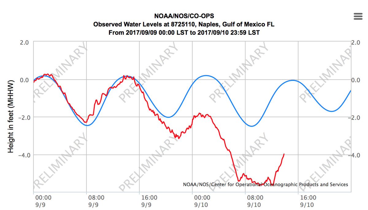
Going to be close for a landfall at Marco Island (official, I mean.) They are going to get the eye, but not sure if it will be the center of the eye. Official landfall might end up just north of there. But close enough.
BULLETIN - EAS ACTIVATION REQUESTED Flash Flood Warning National Weather Service Miami FL 312 PM EDT SUN SEP 10 2017
...FLASH FLOOD EMERGENCY FOR COLLIER COUNTY...
The National Weather Service in Miami has issued a
* Flash Flood Warning for... Southwestern Collier County in southwestern Florida...
* Until 600 PM EDT
* At 300 PM EDT, Doppler radar indicated the center of Hurricane Irma was near Marco Island. Flash flooding from life-threatening storm surge is expected to begin shortly along coastal Collier County. This is a FLASH FLOOD EMERGENCY for Collier County. This is a PARTICULARLY DANGEROUS SITUATION. EVACUATE VERTICALLY NOW!
* Some locations that will experience flooding include... Naples, Marco Island, Chokoloskee, and Everglades City
Last edited by AdamFirst on Sun Sep 10, 2017 2:17 pm, edited 1 time in total.
0 likes
DolphinsMarlinsCanesGolden PanthersHEAT Andrew 1992 - Irene 1999 - Frances 2004 - Jeanne 2004 - Wilma 2005 - Fay 2008 - Isaac 2012 - Matthew 2016 - Irma 2017 - Dorian 2019 - Ian 2022 - Nicole 2022 - Milton 2024
Someone just posted some video on wunderground of a live video from what (must be Marco Island), getting hammered there probably not Rockport lvl winds but 90-100 sustained gusting to 120-130 at times it seems