BULLETIN
Tropical Depression Fourteen Advisory Number 1
NWS National Hurricane Center Miami FL AL142017
1100 PM AST Thu Sep 14 2017
...TROPICAL DEPRESSION FORMS OVER THE EASTERN ATLANTIC...
SUMMARY OF 1100 PM AST...0300 UTC...INFORMATION
-----------------------------------------------
LOCATION...10.7N 25.4W
ABOUT 380 MI...610 KM SSW OF THE CABO VERDE ISLANDS
MAXIMUM SUSTAINED WINDS...35 MPH...55 KM/H
PRESENT MOVEMENT...WNW OR 285 DEGREES AT 22 MPH...35 KM/H
MINIMUM CENTRAL PRESSURE...1010 MB...29.83 INCHES
ATL: LEE - Post-Tropical Low - Discussion
Moderator: S2k Moderators
-
cycloneye

- Admin

- Posts: 149289
- Age: 69
- Joined: Thu Oct 10, 2002 10:54 am
- Location: San Juan, Puerto Rico
Re: ATL: FOURTEEN - Tropical Depression - Discussion
0 likes
Visit the Caribbean-Central America Weather Thread where you can find at first post web cams,radars
and observations from Caribbean basin members Click Here
and observations from Caribbean basin members Click Here
-
HurricaneRyan
- Category 3

- Posts: 846
- Age: 32
- Joined: Sun Dec 05, 2010 3:05 pm
Re: ATL: FOURTEEN - Tropical Depression - Discussion
Smells like a recurve
0 likes
Kay '22 Hilary '23


Re: ATL: FOURTEEN - Tropical Depression - Discussion
HurricaneRyan wrote:Smells like a recurve
Let's hope that it's a re-curve out at sea (a fish)!
0 likes
Not a professional forecast by any means.
Audrey'57, Hilda'64, Betsy '65, Edith'71, Carmen'74, Danny'85, Juan'85, Andrew'92, Iniki'92 (while on vacation in Kauai), Lili'02, Rita'05, Humberto'07, Gustav'08, Ike'08, Isaac'12, Monsoonal Depression'16, Harvey'17, Barry'19, Laura'20, Delta'20, Ida'21.
Audrey'57, Hilda'64, Betsy '65, Edith'71, Carmen'74, Danny'85, Juan'85, Andrew'92, Iniki'92 (while on vacation in Kauai), Lili'02, Rita'05, Humberto'07, Gustav'08, Ike'08, Isaac'12, Monsoonal Depression'16, Harvey'17, Barry'19, Laura'20, Delta'20, Ida'21.
-
Sciencerocks
- Category 5

- Posts: 10181
- Age: 40
- Joined: Thu Jul 06, 2017 1:51 am
Re: ATL: FOURTEEN - Tropical Depression - Discussion
Seems to have nice banding and has sustained convection. We'll have to wait until Tafb and Sab says 2.5t. 
0 likes
-
cycloneye
- Admin
- Posts: 149289
- Age: 69
- Joined: Thu Oct 10, 2002 10:54 am
- Location: San Juan, Puerto Rico
Re: ATL: FOURTEEN - Tropical Depression - Discussion
Tropical Depression Fourteen Discussion Number 4
NWS National Hurricane Center Miami FL AL142017
500 PM AST Fri Sep 15 2017
The depression has become less organized since earlier today with
the center now exposed to the north and northwest of the deep
convection due to northwesterly shear. Dvorak data T-numbers have
decreased, but an average of the current intensity numbers of
1.5 and 2.5 support maintaining an initial wind speed of 30 kt.
Although the depression is forecast to move over warm water,
moderate northwesterly shear and dry mid-level air to the north
of the cyclone is likely to prevent significant intensification.
However, most of the intensity guidance shows some strengthening and
the depression is forecast to become a tropical storm within the
next day or two. After that time, increasing westerly shear
produced by a mid- to upper-level trough over the central Atlantic
is expected to weaken the system, and the tropical cyclone is now
forecast to degenerate to a remnant low by day 5. The new NHC
intensity forecast has been adjusted downward to be in better
agreement with the various intensity consensus aids.
The depression has jogged a little northward this afternoon, but the
long-term motion is west-northwestward at about 10 kt. The
depression is expected to move westward to west-northwestward to
the south of a narrow ridge over the eastern Atlantic over the
weekend. By early next week, the ridge is forecast to weaken as a
deep-layer trough becomes established over the east-central
Atlantic. This should cause the cyclone to gain some latitude
later in the forecast period. The more northward initial position
has required a northward adjustment of the track forecast, but the
NHC track remains along the southern side of the guidance envelope,
in agreement with the typically reliable HFIP corrected consensus
model.
FORECAST POSITIONS AND MAX WINDS
INIT 15/2100Z 12.6N 29.7W 30 KT 35 MPH
12H 16/0600Z 12.8N 30.8W 30 KT 35 MPH
24H 16/1800Z 12.9N 32.2W 35 KT 40 MPH
36H 17/0600Z 13.0N 33.4W 40 KT 45 MPH
48H 17/1800Z 13.2N 34.7W 40 KT 45 MPH
72H 18/1800Z 14.6N 38.4W 35 KT 40 MPH
96H 19/1800Z 16.5N 42.5W 30 KT 35 MPH
120H 20/1800Z 18.5N 46.5W 25 KT 30 MPH...POST-TROP/REMNT LOW
$$
Forecaster Brown
0 likes
Visit the Caribbean-Central America Weather Thread where you can find at first post web cams,radars
and observations from Caribbean basin members Click Here
and observations from Caribbean basin members Click Here
-
emeraldislenc
- Category 2

- Posts: 601
- Joined: Fri Aug 24, 2012 4:49 pm
- Location: Emerald Isle NC
Re: ATL: FOURTEEN - Tropical Depression - Discussion
With the trough becoming well established could this mean the Cape Verde season is winding down?
0 likes
-
bob rulz
- Category 5
- Posts: 1711
- Age: 35
- Joined: Sat Jan 28, 2006 7:30 pm
- Location: Salt Lake City, Utah
Re: ATL: FOURTEEN - Tropical Depression - Discussion
Climatologically speaking, we are nearing the end of the Cape Verde season. We've never seen them later than about September 25th iirc
0 likes

Re: ATL: FOURTEEN - Tropical Depression - Discussion
bob rulz wrote:Climatologically speaking, we are nearing the end of the Cape Verde season. We've never seen them later than about September 25th iirc
Africa is pretty dry right now, with the exception of one more active wave which the Euro wants to develop.
0 likes
-
emeraldislenc
- Category 2
- Posts: 601
- Joined: Fri Aug 24, 2012 4:49 pm
- Location: Emerald Isle NC
Re: ATL: FOURTEEN - Tropical Depression - Discussion
Thanks for all the responses it just seemed to me it might be winding down.
0 likes
-
CrazyC83
- Professional-Met

- Posts: 34315
- Joined: Tue Mar 07, 2006 11:57 pm
- Location: Deep South, for the first time!
Re: ATL: FOURTEEN - Tropical Depression - Discussion
Waves often move off Africa well through September and even into October, but they don't usually develop until they get near or past 50W once into late September.
0 likes
-
CyclonicFury

- Category 5
- Posts: 2032
- Age: 27
- Joined: Sun Jul 02, 2017 12:32 pm
- Location: NC
- Contact:
Re: ATL: FOURTEEN - Tropical Depression - Discussion
CrazyC83 wrote:Waves often move off Africa well through September and even into October, but they don't usually develop until they get near or past 50W once into late September.
I've always wondered this. Why is the Eastern MDR always so quiet in October? SSTs are still warm, SAL is not a problem, is shear the main issue? The MDR manages to produce more storms in July (when it's very dry and dusty out there, as well as cooler) than October. This doesn't make any sense to me.
1 likes
NCSU B.S. in Meteorology Class of 2021. Tropical weather blogger at http://www.cyclonicfury.com. My forecasts and thoughts are NOT official, for official forecasts please consult the National Hurricane Center.
-
NotSparta

- Professional-Met
- Posts: 1677
- Age: 24
- Joined: Fri Aug 18, 2017 8:24 am
- Location: Naples, FL
- Contact:
Re: ATL: FOURTEEN - Tropical Depression - Discussion
CyclonicFury wrote:CrazyC83 wrote:Waves often move off Africa well through September and even into October, but they don't usually develop until they get near or past 50W once into late September.
I've always wondered this. Why is the Eastern MDR always so quiet in October? SSTs are still warm, SAL is not a problem, is shear the main issue? The MDR manages to produce more storms in July (when it's very dry and dusty out there, as well as cooler) than October. This doesn't make any sense to me.
I think it's shear, because the trough becomes more defined and shears a lot of disturbances in the MDR
0 likes
This post was probably an opinion of mine, and in no way is official. Please refer to http://www.hurricanes.gov for official tropical analysis and advisories.
My website, with lots of tropical wx graphics, including satellite and recon: http://cyclonicwx.com
My website, with lots of tropical wx graphics, including satellite and recon: http://cyclonicwx.com
-
HenkL
- S2K Supporter

- Posts: 2401
- Joined: Fri Sep 10, 2004 5:33 pm
- Location: Groningen, The Netherlands
- Contact:
Re: ATL: FOURTEEN - Tropical Depression - Discussion
The Intertropical Convergence Zone (ITCZ) moves southward towards the equator, where there is no Coriolis force.
1 likes
-
CrazyC83
- Professional-Met
- Posts: 34315
- Joined: Tue Mar 07, 2006 11:57 pm
- Location: Deep South, for the first time!
Re: ATL: FOURTEEN - Tropical Depression - Discussion
16/0000 UTC 12.8N 30.2W T2.0/2.0 14L -- Atlantic
0 likes
-
CrazyC83
- Professional-Met
- Posts: 34315
- Joined: Tue Mar 07, 2006 11:57 pm
- Location: Deep South, for the first time!
Re: ATL: FOURTEEN - Tropical Depression - Discussion
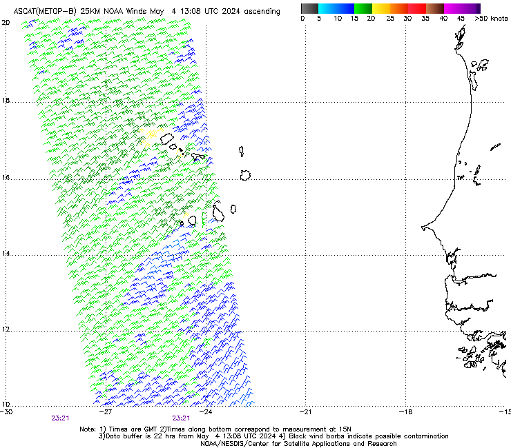
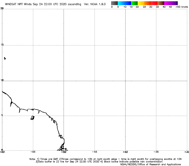
https://manati.star.nesdis.noaa.gov/asc ... Bas124.png
https://manati.star.nesdis.noaa.gov/win ... 6_noaa.png
I see a bunch of 30 kt wind barbs and possibly a 35 kt barb in the partial ASCAT pass. I also see a 35 kt barb on the WindSat pass.
https://manati.star.nesdis.noaa.gov/win ... 6_noaa.png
I see a bunch of 30 kt wind barbs and possibly a 35 kt barb in the partial ASCAT pass. I also see a 35 kt barb on the WindSat pass.
1 likes
-
galaxy401

- Category 5
- Posts: 2446
- Age: 30
- Joined: Sat Aug 25, 2012 9:04 pm
- Location: Casa Grande, Arizona
Re: ATL: FOURTEEN - Tropical Depression - Discussion
What is the longest a Tropical Depression went before being upgraded to a Tropical Storm?
0 likes
Got my eyes on moving right into Hurricane Alley: Florida.
-
CrazyC83
- Professional-Met
- Posts: 34315
- Joined: Tue Mar 07, 2006 11:57 pm
- Location: Deep South, for the first time!
Re: ATL: FOURTEEN - Tropical Depression - Discussion
galaxy401 wrote:What is the longest a Tropical Depression went before being upgraded to a Tropical Storm?
TD15-E in the EPAC has gone 17 advisories without an upgrade, and in the Atlantic I am sure there have been many that have gone a long time too.
0 likes
-
galaxy401
- Category 5
- Posts: 2446
- Age: 30
- Joined: Sat Aug 25, 2012 9:04 pm
- Location: Casa Grande, Arizona
Re: ATL: FOURTEEN - Tropical Depression - Discussion
CrazyC83 wrote:galaxy401 wrote:What is the longest a Tropical Depression went before being upgraded to a Tropical Storm?
TD15-E in the EPAC has gone 17 advisories without an upgrade, and in the Atlantic I am sure there have been many that have gone a long time too.
Oh I just realized I posted this on the wrong topic. Got the depressions mixed up.
1 likes
Got my eyes on moving right into Hurricane Alley: Florida.

Re: ATL: FOURTEEN - Tropical Depression - Discussion
galaxy401 wrote:What is the longest a Tropical Depression went before being upgraded to a Tropical Storm?
http://tropicalatlantic.com/models/models.cgi?basin=al&year=1970&storm=15 though given satellite imagery I've seen I can see it being upped to a TS on reanalysis.
1 likes
The above post is not official and should not be used as such. It is the opinion of the poster and may or may not be backed by sound meteorological data. It is not endorsed by any professional institution or storm2k.org. For official information, please refer to the NHC and NWS products.
-
Sciencerocks
- Category 5
- Posts: 10181
- Age: 40
- Joined: Thu Jul 06, 2017 1:51 am
Re: ATL: FOURTEEN - Tropical Depression - Discussion
If the LLC is under the convection then this system looks really good this morning...
0 likes
Who is online
Users browsing this forum: No registered users and 9 guests