ATL: NATE - Post Tropical - Discussion

Moderator: S2k Moderators

Message
Author
User avatar
kevin mathis
Tropical Depression
Tropical Depression
Posts: 56
Joined: Tue Sep 20, 2005 9:39 pm
Location: Tampa Bay

Re: ATL: SIXTEEN - Models

#601 Postby kevin mathis » Wed Oct 04, 2017 7:11 pm

johngaltfla wrote:
PSUHiker31 wrote:
CrazyC83 wrote:Not sure the resolution, but I noticed that very few of the GFS ensembles even have a hurricane (I see maybe 2 with a pressure lower than 990).


GFS has it going over more land and weird interference from the Florida disturbance


Weird is the CMC. It's like watching the ultimate disaster movie with each run. :double:


Yea...Doesn't it spin off 3 different storms. One becomes a monster in central Gulf with front approaching...
0 likes   

jlauderdal
S2K Supporter
S2K Supporter
Posts: 7183
Joined: Wed May 19, 2004 5:46 am
Location: NE Fort Lauderdale
Contact:

Re: ATL: SIXTEEN - Tropical Depression - Discussion

#602 Postby jlauderdal » Wed Oct 04, 2017 7:12 pm

johngaltfla wrote:
dizzyfish wrote:After reading here today and listening to the local mets and my own research we have decided to prepare for at least power outage (due to already damaged trees) and possible TS winds so will remove lightweight objects from the yard. After Irma I didn't put all my foo foo back out in the yard - just bird feeders and the table and chairs.

We don't plan on boarding up unless the track shifts or the category and size increases. (Florida West Coast, Pasco County)


I'm not putting my boards back into storage until AFTER the first real cold front breaks through the peninsula.
my shutters are still outside underneath each opening after irma, they will be put away sometime in november
1 likes   

User avatar
johngaltfla
Category 5
Category 5
Posts: 2069
Joined: Sun Jul 10, 2005 9:17 pm
Location: Sarasota County, FL
Contact:

Re: ATL: SIXTEEN - Tropical Depression - Discussion

#603 Postby johngaltfla » Wed Oct 04, 2017 7:14 pm

NDG wrote:One thing that the subtropical looking disturbance approaching FL will do is moisten up the atmosphere quite nice as it moves westward across the GOM ahead of TD 16.


Yeah. Yee-haw. We can go from 22 inches over for the year to 30. I can't wait for SWFWMD to tell us that we can only use the sprinklers once a week in January. Boy do I have a reply planned for them. :spam:
1 likes   

User avatar
johngaltfla
Category 5
Category 5
Posts: 2069
Joined: Sun Jul 10, 2005 9:17 pm
Location: Sarasota County, FL
Contact:

Re: ATL: SIXTEEN - Tropical Depression - Discussion

#604 Postby johngaltfla » Wed Oct 04, 2017 7:15 pm

jlauderdal wrote:
johngaltfla wrote:
dizzyfish wrote:After reading here today and listening to the local mets and my own research we have decided to prepare for at least power outage (due to already damaged trees) and possible TS winds so will remove lightweight objects from the yard. After Irma I didn't put all my foo foo back out in the yard - just bird feeders and the table and chairs.

We don't plan on boarding up unless the track shifts or the category and size increases. (Florida West Coast, Pasco County)


I'm not putting my boards back into storage until AFTER the first real cold front breaks through the peninsula.
my shutters are still outside underneath each opening after irma, they will be put away sometime in november


I'm praying the long range forecasts which indicate a cold front at the end of the month with lows in the high 50's is right. The GoM has to start cooling down or we're going to have a long November also.
0 likes   

User avatar
kevin mathis
Tropical Depression
Tropical Depression
Posts: 56
Joined: Tue Sep 20, 2005 9:39 pm
Location: Tampa Bay

Re: ATL: SIXTEEN - Models

#605 Postby kevin mathis » Wed Oct 04, 2017 7:16 pm

[youtube]https://youtu.be/UiJ0KfgQxAA[/youtube]

Just in case you haven't seen this from Levi. Great breakdown of why GFS and Euro see things so differently
9 likes   

User avatar
johngaltfla
Category 5
Category 5
Posts: 2069
Joined: Sun Jul 10, 2005 9:17 pm
Location: Sarasota County, FL
Contact:

Re: ATL: SIXTEEN - Models

#606 Postby johngaltfla » Wed Oct 04, 2017 7:16 pm

kevin mathis wrote:
johngaltfla wrote:
PSUHiker31 wrote:
GFS has it going over more land and weird interference from the Florida disturbance


Weird is the CMC. It's like watching the ultimate disaster movie with each run. :double:


Yea...Doesn't it spin off 3 different storms. One becomes a monster in central Gulf with front approaching...


It's the storm modeling you watch if you want to live in a permanent state of terror if you live in Hurricane Alley.
3 likes   

User avatar
Steve
S2K Supporter
S2K Supporter
Posts: 9621
Joined: Sat Apr 05, 2003 11:41 pm
Location: Not a state-caster

Re: ATL: SIXTEEN - Models

#607 Postby Steve » Wed Oct 04, 2017 7:17 pm

johngaltfla wrote:
PSUHiker31 wrote:
CrazyC83 wrote:Not sure the resolution, but I noticed that very few of the GFS ensembles even have a hurricane (I see maybe 2 with a pressure lower than 990).


GFS has it going over more land and weird interference from the Florida disturbance


Weird is the CMC. It's like watching the ultimate disaster movie with each run. :double:


True. But CMC outperformed GFS in the 3-4 day window with Irma and maintained a system in the West Gulf leading into Harvey when the GFS and European killed it off in the mid-range period. Also, the NAM of all models was the one to forecast the explosive pressure falls that became a Cat 4 in Harvey. It was below 25N then too which is the edge of the NAM's questionable range to begin with. The European is good, sometimes better than NHC (see Irma). But it misses storms and patterns pretty frequently. It's been terrible with ENSO this year (CFSV2 has been much closer) and it hasn't done all that great with MJO though it has done okay at times with that. It's a major factor and one I take seriously. But it's way overrated on this forum. Even Euro huggers would agree with that.

As for ECMWF only coming around to the GFS once, it happens pretty frequently. ECMWF was the southern outlier for Charley and wasn't close with that solution. There are plenty of others - but I'm not about to go back and research.
3 likes   

User avatar
dizzyfish
S2K Supporter
S2K Supporter
Posts: 1519
Joined: Fri Sep 16, 2005 7:56 am
Location: New Port Richey, FL

Re: ATL: SIXTEEN - Models

#608 Postby dizzyfish » Wed Oct 04, 2017 7:17 pm

QUESTION

Isn't the real issue of track based on all models initializing correctly (at the same point)?

Until that happens I think the models are mostly all over the board and any one model may be correct - at least for a short time.

Please correct me if I'm wrong.

When the upper atmosphere dynamics are fed into the models along with the info from the HH's then we will see the models become cohesive. Yes?
1 likes   

User avatar
dizzyfish
S2K Supporter
S2K Supporter
Posts: 1519
Joined: Fri Sep 16, 2005 7:56 am
Location: New Port Richey, FL

Re: ATL: SIXTEEN - Tropical Depression - Discussion

#609 Postby dizzyfish » Wed Oct 04, 2017 7:19 pm

johngaltfla wrote:
jlauderdal wrote:
johngaltfla wrote:
I'm not putting my boards back into storage until AFTER the first real cold front breaks through the peninsula.
my shutters are still outside underneath each opening after irma, they will be put away sometime in november


I'm praying the long range forecasts which indicate a cold front at the end of the month with lows in the high 50's is right. The GoM has to start cooling down or we're going to have a long November also.


Oh the shutters aren't in storage - just out of the way in the extra garage. :D This year I don't trust Mother Nature!
2 likes   

CrazyC83
Professional-Met
Professional-Met
Posts: 34002
Joined: Tue Mar 07, 2006 11:57 pm
Location: Deep South, for the first time!

Re: ATL: SIXTEEN - Tropical Depression - Discussion

#610 Postby CrazyC83 » Wed Oct 04, 2017 7:22 pm

It appears the center is a bit south and east of the advisory position (around 12.4N 82.4W). There is significant tilt between the LLC and MLC.

Image
1 likes   

WeatherEmperor
S2K Supporter
S2K Supporter
Posts: 4806
Age: 41
Joined: Thu Sep 04, 2003 2:54 pm
Location: South Florida

Re: ATL: SIXTEEN - Models

#611 Postby WeatherEmperor » Wed Oct 04, 2017 7:24 pm

18z NAVGEM shifted WAY west with landfall in central LA. The Euro and UKMET stand alone as eastern solutions. I sense major bustation for some of the models here.....

Image


Sent from my iPhone using Tapatalk
0 likes   

User avatar
GCANE
S2K Supporter
S2K Supporter
Posts: 11497
Joined: Mon Oct 22, 2007 8:03 am

Re: ATL: SIXTEEN - Tropical Depression - Discussion

#612 Postby GCANE » Wed Oct 04, 2017 7:27 pm

Core is warming up

Image
0 likes   

BZSTORM
Category 1
Category 1
Posts: 331
Age: 60
Joined: Tue Jul 15, 2008 5:47 pm
Location: Placencia, Belize

Re: ATL: SIXTEEN - Tropical Depression - Discussion

#613 Postby BZSTORM » Wed Oct 04, 2017 7:32 pm

NEMO BELIZE has been activated in regard to TD 16 today Oct 4 2017. This is because our Met dept believes there is a strong possibility of rain to create flash flooding (water table already at max countrywide) and a stay safe harbor for after Friday for high seas.

National Emergency Management Organization

“Preserving Life and Property”

11:00 A.M, WEDNESDAY 4th, OCTOBER 2017

TROPICAL DEPRESSION SIXTEEN (TD 16) FORMS OFF THE COAST OF NICARAGUA

ADVISORY NO. 1

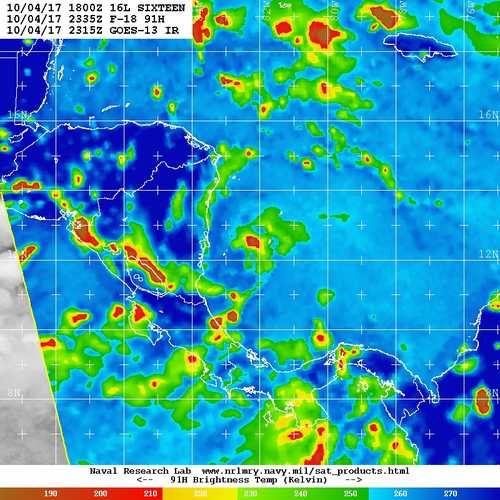
NEMO in collaboration with the National Meteorological Service hereby informs the general public that Tropical Depression Sixteen (16) with maximum sustained winds of 35 miles per hour recently formed off the coast of Nicaragua. TD 16 is located at 12.2 North Latitude and 81.9 West Longitude. It is moving due northwest at 7 miles per hour. It is forecasted to continue move in that direction. If it maintains its projected path based on that forecast it is expected to become a Tropical Storm and by Friday, 6th October 2017 it is expected to be east of Belize, or directly in front of us.

The public is hereby advised to make preparations to protect life and property. If you are at risk to bad weather and flooding start discussing arrangements to move to higher grounds. If you have to seek shelter, know which shelter you will go to and make arrangements on how you will reach the shelter. Start checking on family members and neighbors who may be in need of assistance. Secure as much food and water as possible.

Do not venture out to sea after Friday, 6th October 2017. All Fishers and people on the Cayes are hereby strongly urged to monitor and track TD 16.

Drivers are reminded to drive with extreme caution, reduce speed and put on your hazard light, when driving in wet conditions. NEMO’s Emergency Coordinators contact information are as follows:

Corozal, Mr. Williard Levy at 623 0237;
Orange Walk, Ms. Suliema Celiz at 605 5046, or Mr. Aragon at 636 6094;
Belize District, Mr. Lionel Tillett at 6154834 and Mr. Kevin Pollard at 621 2275;
San Pedro, Ms. Vanessa Parham at 632 3698;
Belize City, Ms. Timrose Augustine at 600 8672 and Councillor Willoughby at 615 9793;
Belmopan, Ms. Clare Moody at 630 9791;
Cayo, Mr. Al Westby at 630 3224 or Mr. Johnny Ramclam at 625 2526;
Stann Creek, Mr. Keith Emmanuel at 615 9711; and
Toledo, Mr. Kenton Parham at 630 9787.
The NEMO Emergency Hotline is 936. NEMO IS ON ALERT.
(Advisories are sent out to: (1) inform the public about developing or existing emergency situation such as tropical cyclone activities, (2) what the government and NEMO are doing and, (3) what actions the public are advised to take. They are not intended to predict what a tropical cyclone will do and where it will go.)
http://site.nemo.org.bz/


Please continue to pay attention to the National Meteorological Service weather report and NEMO advisories.


:-End of Release:-
2 likes   

BYG Jacob

Re: ATL: SIXTEEN - Tropical Depression - Discussion

#614 Postby BYG Jacob » Wed Oct 04, 2017 7:35 pm

CrazyC83 wrote:It appears the center is a bit south and east of the advisory position (around 12.4N 82.4W). There is significant tilt between the LLC and MLC.

Image

What looks to be the cause of that tilt? There isn't any shear.
0 likes   

User avatar
EquusStorm
Category 5
Category 5
Posts: 1649
Age: 34
Joined: Thu Nov 07, 2013 1:04 pm
Location: Jasper, AL
Contact:

Re: ATL: SIXTEEN - Tropical Depression - Discussion

#615 Postby EquusStorm » Wed Oct 04, 2017 7:39 pm

With how weak the actual LLC appears to be despite impressive banding and overall organization, I wonder how long it will take to recover its low level organization after passing across land in Central America and perhaps the Yucatan as well. Conditions are very volatile and support rapid intensification, no doubt, but given that it's supposed to accelerate once it passes the Yucatan, every hour of hampered organization may count if it intensifies all the way to land. If there is any dry air around to be entrained into the core should it pass close enough, that would also be good news for the Gulf Coast.

Reminds me a little of Ida 2009, in overall track shape, but I highly doubt it becomes an 80mph hurricane prior to striking Nicaragua...
0 likes   
Colors of lost purpose on the canvas of irrelevance

Not a meteorologist, in fact more of an idiot than anything. You should probably check with the NHC or a local NWS office for official information.

stormreader

Re: ATL: SIXTEEN - Models

#616 Postby stormreader » Wed Oct 04, 2017 7:46 pm

WeatherEmperor wrote:18z NAVGEM shifted WAY west with landfall in central LA. The Euro and UKMET stand alone as eastern solutions. I sense major bustation for some of the models here.....

Image

Wonder which ones? Lol. Well, I know, it's only the Navgem.....It's obvious that the Euro is the best model we have, but it's not infallible. I think part of what's happening here is the assumption that a NE Gulf Coast hit in October just must be the solution. But the flow in the north GOM is unusual for this time of year (at least until that front makes its approach early next week). Also not completely sure what the depth and shape of that trough will be. The path toward the Fl panhandle is more likely in early October, but it is not written in stone. There are storms in history which have traveled from the Yucatan Channel to the La coast in the first 10 days of October. All I'm saying is that we have to be careful that we don't have a built-in east bias at this time of year.
Sent from my iPhone using Tapatalk
1 likes   

PSUHiker31
Tropical Storm
Tropical Storm
Posts: 114
Joined: Tue Oct 03, 2017 2:36 pm

Re: ATL: SIXTEEN - Models

#617 Postby PSUHiker31 » Wed Oct 04, 2017 7:50 pm

Btw, it's intriguing that the HMON brings it down to 907 mb a run after struggling to materialize it. Of course, I've noticed the HMON to seem to be in a permanent beta phase this entire year.

The HWRF strengthening the pressure but not the winds too much is also intriguing
2 likes   

User avatar
CaneCurious
Tropical Storm
Tropical Storm
Posts: 160
Joined: Wed Aug 25, 2004 1:40 pm
Location: Kenner, LA

Re: ATL: SIXTEEN - Models

#618 Postby CaneCurious » Wed Oct 04, 2017 7:52 pm

Levi explained the 2 scenarios perfectly. It seems that tomorrow Is the day that we will see which model is correct.


Just in case you haven't seen this from Levi. Great breakdown of why GFS and Euro see things so differently[/quote]
3 likes   

User avatar
Blown Away
S2K Supporter
S2K Supporter
Posts: 10146
Joined: Wed May 26, 2004 6:17 am

Re: ATL: SIXTEEN - Tropical Depression - Discussion

#619 Postby Blown Away » Wed Oct 04, 2017 8:13 pm

Image
Looking at NHC track and recent SAB points, 16L not moving much ATM...
2 likes   
Hurricane Eye Experience: David 79, Irene 99, Frances 04, Jeanne 04, Wilma 05... EYE COMING MY WAY IN 2024…
Hurricane Brush Experience: Andrew 92, Erin 95, Floyd 99, Matthew 16, Irma 17, Ian 22, Nicole 22…

User avatar
Blown Away
S2K Supporter
S2K Supporter
Posts: 10146
Joined: Wed May 26, 2004 6:17 am

Re: ATL: SIXTEEN - Models

#620 Postby Blown Away » Wed Oct 04, 2017 8:30 pm

Image

Interesting the NHC/EURO out on an island while all others go west by hundreds of miles...

Let the EURO & Levi know it's been raining real hard this evening in in the E Central Florida area... :D
0 likes   
Hurricane Eye Experience: David 79, Irene 99, Frances 04, Jeanne 04, Wilma 05... EYE COMING MY WAY IN 2024…
Hurricane Brush Experience: Andrew 92, Erin 95, Floyd 99, Matthew 16, Irma 17, Ian 22, Nicole 22…


Return to “2017”

Who is online

Users browsing this forum: No registered users and 5 guests