SLIDER
http://rammb-slider.cira.colostate.edu/?sat=himawari&sec=full_disk&x=8782&y=6524&z=4&im=18&ts=1&st=0&et=0&speed=130&motion=loop&map=1&lat=0&p%5B0%5D=16&opacity%5B0%5D=1&hidden%5B0%5D=0&pause=0&slider=-1&hide_controls=0&mouse_draw=0&s=rammb-slider
WPAC: LAN - Typhoon
Moderator: S2k Moderators
-
tolakram
- Admin

- Posts: 20179
- Age: 62
- Joined: Sun Aug 27, 2006 8:23 pm
- Location: Florence, KY (name is Mark)
Re: WPAC: LAN - Typhoon
0 likes
M a r k
- - - - -
Join us in chat: Storm2K Chatroom Invite. Android and IOS apps also available.
The posts in this forum are NOT official forecasts and should not be used as such. Posts are NOT endorsed by any professional institution or STORM2K.org. For official information and forecasts, please refer to NHC and NWS products.
-
tolakram
- Admin
- Posts: 20179
- Age: 62
- Joined: Sun Aug 27, 2006 8:23 pm
- Location: Florence, KY (name is Mark)
Re: WPAC: LAN - Typhoon

2 likes
M a r k
- - - - -
Join us in chat: Storm2K Chatroom Invite. Android and IOS apps also available.
The posts in this forum are NOT official forecasts and should not be used as such. Posts are NOT endorsed by any professional institution or STORM2K.org. For official information and forecasts, please refer to NHC and NWS products.
- - - - -
Join us in chat: Storm2K Chatroom Invite. Android and IOS apps also available.
The posts in this forum are NOT official forecasts and should not be used as such. Posts are NOT endorsed by any professional institution or STORM2K.org. For official information and forecasts, please refer to NHC and NWS products.
Re: WPAC: LAN - Typhoon
supercane4867 wrote:CrazyC83 wrote:euro6208 wrote:Amazing how Lan was able to get up to 7.0 so quickly. In Irma's and Maria's, Dvorak was 6.0 to 6.5 when they were found to be upper end Cat 5's. Being underestimated here. Very warm eye with very cold cloud tops.
ADT is showing a lower estimate, probably due to the very large eye. It's tough when there is conflicting data - the eye is much larger than Irma or Maria had at peak intensity. That said, there isn't much experience with large eyes and areas of cold cloud tops in the Atlantic with Recon.
AMSU estimate is also running way lower than Irma and Maria had at peak intensity. If you take the blend of data, 130kt seems to be a good fit.
The relatively loose structure with over-sized eye on microwave and visible imagery just don't scream CAT5 intensity to me.
CIMSS/NESDIS-USAF/NRL AMSU TC Intensity Estimation:
TYPHOON 25W
Friday 20oct17 Time: 1300 UTC
Latitude: 19.97 Longitude: 130.43
Storm position corresponds to AMSU-A FOV 27 [1<--->30]
-----------------------------------------------------------------
| Estimated MSLP: 934 hPa
| Estimated Maximum Sustained Wind: 107 kts
| Estimate Confidence: Fair ( +/- 15mb +/- 20kts )
-----------------------------------------------------------------
Channel 8 (~150 hPa) Tb Anomaly: 5.02
Channel 7 (~250 hPa) Tb Anomaly: 4.89
RMW: 49 km
RMW Source is: IR
Environmental Pressure: 1005
Satellite: NOAA-90
ATCF data for Month: 10 Day: 20 Time (UTC): 1200
The AMSU estimate you used is from 12 hours ago. There’s usually a new set of AMSU estimate at around 00Z.
0 likes
Personal Forecast Disclaimer:
The posts in this forum are NOT official forecast and should not be used as such. They are just the opinion of the poster and may or may not be backed by sound meteorological data. They are NOT endorsed by any professional institution or storm2k.org. For official information, please refer to RSMC and NWS products.
The posts in this forum are NOT official forecast and should not be used as such. They are just the opinion of the poster and may or may not be backed by sound meteorological data. They are NOT endorsed by any professional institution or storm2k.org. For official information, please refer to RSMC and NWS products.
-
tolakram
- Admin
- Posts: 20179
- Age: 62
- Joined: Sun Aug 27, 2006 8:23 pm
- Location: Florence, KY (name is Mark)
Re: WPAC: LAN - Typhoon
0 likes
M a r k
- - - - -
Join us in chat: Storm2K Chatroom Invite. Android and IOS apps also available.
The posts in this forum are NOT official forecasts and should not be used as such. Posts are NOT endorsed by any professional institution or STORM2K.org. For official information and forecasts, please refer to NHC and NWS products.
- - - - -
Join us in chat: Storm2K Chatroom Invite. Android and IOS apps also available.
The posts in this forum are NOT official forecasts and should not be used as such. Posts are NOT endorsed by any professional institution or STORM2K.org. For official information and forecasts, please refer to NHC and NWS products.
-
mrbagyo

- Category 5

- Posts: 3963
- Age: 33
- Joined: Thu Apr 12, 2012 9:18 am
- Location: 14.13N 120.98E
- Contact:
Re: WPAC: LAN - Typhoon
2017OCT21 013000 6.4 924.3 124.6 6.1 6.2 6.2 NO LIMIT ON OFF 21.20 -73.94 EYE/L 47 IR 49.6 21.55 -131.46 SPRL
0 likes
The posts in this forum are NOT official forecast and should not be used as such. They are just the opinion of the poster and may or may not be backed by sound meteorological data. They are NOT endorsed by any professional institution or storm2k.org. For official information, please refer to RSMC, NHC and NWS products.
-
mrbagyo
- Category 5
- Posts: 3963
- Age: 33
- Joined: Thu Apr 12, 2012 9:18 am
- Location: 14.13N 120.98E
- Contact:
Re: WPAC: LAN - Typhoon
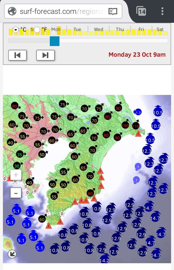
Will there be funneling on the bay?
Figures for wave are in meters / wind - kph
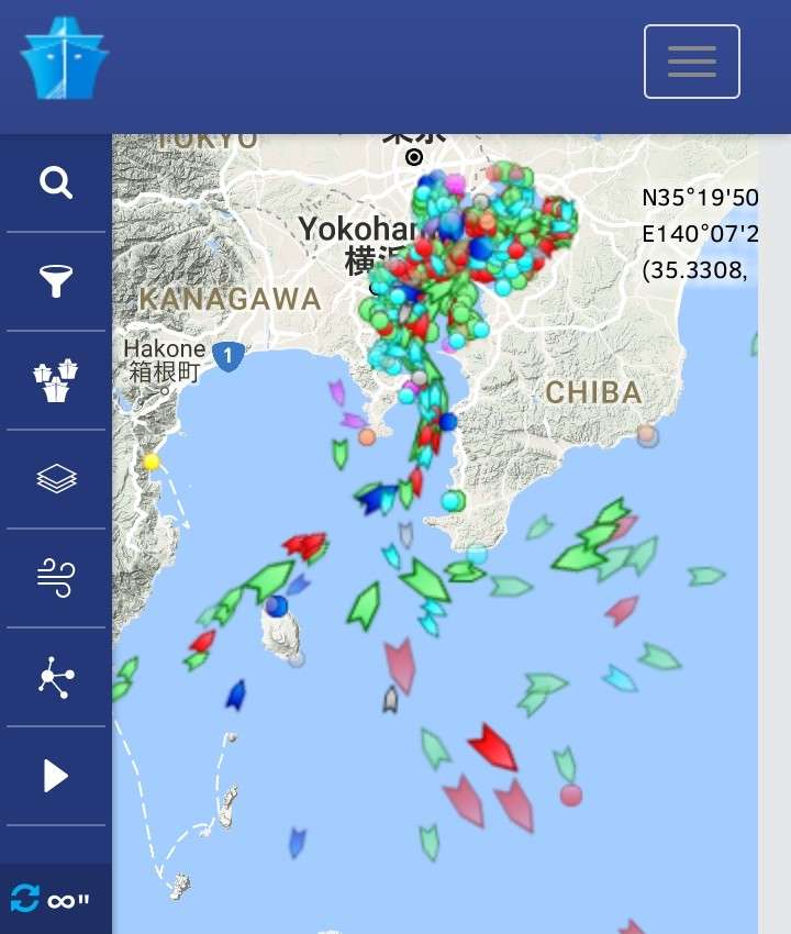
 Near real time ships traffic via marinetraffic.com
Figures for wave are in meters / wind - kph
0 likes
The posts in this forum are NOT official forecast and should not be used as such. They are just the opinion of the poster and may or may not be backed by sound meteorological data. They are NOT endorsed by any professional institution or storm2k.org. For official information, please refer to RSMC, NHC and NWS products.
-
euro6208
Re: WPAC: LAN - Typhoon
WDPN32 PGTW 210300
MSGID/GENADMIN/JOINT TYPHOON WRNCEN PEARL HARBOR HI//
SUBJ/PROGNOSTIC REASONING FOR SUPER TYPHOON 25W (LAN) WARNING NR 23//
RMKS/
1. FOR METEOROLOGISTS.
2. 6 HOUR SUMMARY AND ANALYSIS.
SUPER TYPHOON (STY) 25W (LAN), LOCATED APPROXIMATELY 358 NM SOUTH-
SOUTHEAST OF KADENA AB, HAS TRACKED NORTHEASTWARD AT 08 KNOTS OVER
THE PAST SIX HOURS. ANIMATED MULTISPECTRAL SATELLITE IMAGERY DEPICTS
A SYMMETRIC EYEWALL SURROUNDING A 50NM ROUND EYE. STY 25W HAS
RAPIDLY INTENSIFIED (RI) OVER THE PAST 24 HOURS FROM 85 KNOTS TO
135 KNOTS (50 KNOTS). UPPER-LEVEL ANALYSIS INDICATES EXCELLENT
OUTFLOW, PARTICULARLY POLEWARD, WHICH IS TAPPING INTO THE
MIDLATITUDE WESTERLIES OVER JAPAN. A 202147Z WINDSAT 37GHZ IMAGE
SHOWS SPIRAL BANDING WRAPPING INTO THE SYSTEM WITH A WELL-DEFINED
MICROWAVE EYE FEATURE. THE INITIAL INTENSITY IS ASSESSED AT 135
KNOTS BASED ON DVORAK CURRENT INTENSITY ESTIMATES RANGING FROM T6.5
(127 KNOTS) TO T7.0 (140 KNOTS). STY 25W IS TRACKING POLEWARD ALONG
THE WESTERN PERIPHERY OF THE DEEP LAYERED SUBTROPICAL RIDGE.
3. FORECAST REASONING.
A. NO CHANGE TO THE FORECAST PHILOSOPHY SINCE THE PREVIOUS
PROGNOSTIC REASONING MESSAGE.
B. ANIMATED SATELLITE IMAGERY INDICATES SOME EYE WOBBLE, HOWEVER,
STY 25W IS TRACKING GENERALLY POLEWARD TOWARD CENTRAL JAPAN. STY LAN
SHOULD REMAIN AT STY STRENGTH THROUGH THE NEXT 12 HOURS THEN WEAKEN
AS IT APPROACHES JAPAN AND BEGINS TO INTERACT WITH THE BAROCLINIC
ZONE BY TAU 24. AFTER TAU 24, STY 25W WILL ENCOUNTER STRONG VERTICAL
WIND SHEAR, BEGIN TO INTERACT WITH LAND AND WILL WEAKEN
SIGNIFICANTLY. THE SYSTEM WILL COMPLETE EXTRA-TROPICAL TRANSITION BY
TAU 48 AS IT GAINS FRONTAL CHARACTERISTICS AND BEGINS TO ACCELERATE
NORTHEASTWARD. STY 25W IS FORECAST TO MAINTAIN EXTENSIVE GALE-FORCE
WINDS DUE TO THE VERY LARGE SIZE OF THE SYSTEM, AND PROXIMITY OF
COLD-SURGE WINDS AND GRADIENT WINDS ASSOCIATED WITH THE FRONTAL ZONE
CURRENTLY SITUATED OVER JAPAN. DYNAMIC MODEL GUIDANCE REMAINS IN
TIGHT AGREEMENT, THEREFORE, THERE IS HIGH CONFIDENCE IN THE JTWC
FORECAST TRACK.//
NNNN
0 likes
Re: WPAC: LAN - Typhoon
https://headlines.yahoo.co.jp/hl?a=2017 ... nbnv-sctch
Japan conducted the first aircraft recon mission on Lan.
Japan conducted the first aircraft recon mission on Lan.
0 likes
Personal Forecast Disclaimer:
The posts in this forum are NOT official forecast and should not be used as such. They are just the opinion of the poster and may or may not be backed by sound meteorological data. They are NOT endorsed by any professional institution or storm2k.org. For official information, please refer to RSMC and NWS products.
The posts in this forum are NOT official forecast and should not be used as such. They are just the opinion of the poster and may or may not be backed by sound meteorological data. They are NOT endorsed by any professional institution or storm2k.org. For official information, please refer to RSMC and NWS products.
-
Digital-TC-Chaser
Re: WPAC: LAN - Typhoon
NotoSans wrote:https://headlines.yahoo.co.jp/hl?a=20171020-00173308-nbnv-sctch
Japan conducted the first aircraft recon mission on Lan.
Where do view the data. Its no help if its not published for us trackers in real time..
0 likes
-
xtyphooncyclonex

- Category 5
- Posts: 3891
- Age: 24
- Joined: Sat Dec 08, 2012 9:07 am
- Location: Cebu City
- Contact:
Re: WPAC: LAN - Typhoon
wow!!
Have we ever seen this before???
TY 1721 (Lan)
Issued at 09:45 UTC, 21 October 2017
<Analysis at 09 UTC, 21 October>
Scale Very large
Intensity Very strong
Center position N23°00' (23.0°)
E132°20' (132.3°)
Direction and speed of movement NNE 30 km/h (15 kt)
Central pressure 925 hPa
Maximum wind speed near center 50 m/s (95 kt)
Maximum wind gust speed 70 m/s (135 kt)
≥ 50 kt wind area SE 280 km (150 NM)
NW 220 km (120 NM)
≥ 30 kt wind area ALL 950 km (500 NM)
Last edited by xtyphooncyclonex on Sat Oct 21, 2017 7:41 am, edited 1 time in total.
0 likes
REMINDER: My opinions that I, or any other NON Pro-Met in this forum, are unofficial. Please do not take my opinions as an official forecast and warning. I am NOT a meteorologist. Following my forecasts blindly may lead to false alarm, danger and risk if official forecasts from agencies are ignored.
Re: WPAC: LAN - Typhoon
http://www3.nhk.or.jp/news/html/2017102 ... sult=台風21号
JMA conducted another recon mission on Lan today and recon data supports its intensity estimate very well. Central pressure is around 925 hPa and the maximum surface winds recorded by dropsonde are near 70 m/s (probably representative of gust instead of sustained winds).
JMA conducted another recon mission on Lan today and recon data supports its intensity estimate very well. Central pressure is around 925 hPa and the maximum surface winds recorded by dropsonde are near 70 m/s (probably representative of gust instead of sustained winds).
0 likes
Personal Forecast Disclaimer:
The posts in this forum are NOT official forecast and should not be used as such. They are just the opinion of the poster and may or may not be backed by sound meteorological data. They are NOT endorsed by any professional institution or storm2k.org. For official information, please refer to RSMC and NWS products.
The posts in this forum are NOT official forecast and should not be used as such. They are just the opinion of the poster and may or may not be backed by sound meteorological data. They are NOT endorsed by any professional institution or storm2k.org. For official information, please refer to RSMC and NWS products.
-
euro6208
Re: WPAC: LAN - Typhoon
Remains 130 knots.
WDPN32 PGTW 210900
MSGID/GENADMIN/JOINT TYPHOON WRNCEN PEARL HARBOR HI//
SUBJ/PROGNOSTIC REASONING FOR SUPER TYPHOON 25W (LAN) WARNING NR 24//
RMKS/
1. FOR METEOROLOGISTS.
2. 6 HOUR SUMMARY AND ANALYSIS.
SUPER TYPHOON 25W (LAN), LOCATED APPROXIMATELY 337 NM SOUTHEAST
OF KADENA AB, HAS TRACKED NORTHEASTWARD AT 11 KNOTS OVER THE PAST
SIX HOURS. ANIMATED MULTISPECTRAL SATELLITE IMAGERY AND A 210553Z
89GHZ AMSU IMAGE DEPICTS DEEP CONVECTION SURROUNDING A 50NM EYE
FEATURE WITH WARMING CLOUD TOPS INDICATING THE START OF A WEAKENING
TREND. THE INITIAL POSITION IS PLACED WITH HIGH CONFIDENCE BASED ON
THE EVIDENT EYE FEATURE IN SATELLITE IMAGERY. UPPER-LEVEL ANALYSIS
SHOWS DUAL CHANNEL OUTFLOW WITH ENHANCED POLEWARD EXHAUST INTO THE
MID-LATITUDE WESTERLIES CURRENTLY OVER JAPAN. SSTS IN THE REGION ARE
STILL VERY WARM NEAR 29 CELSIUS, HOWEVER, STY 25W HAS TRACKED INTO
AN AREA OF SUBSTANTIALLY LOWER OCEANIC HEAT CONTENT. CURRENTLY STY
25W IS TRACKING POLEWARD ALONG THE WESTERN PERIPHERY OF THE DEEP
LAYERED SUBTROPICAL RIDGE.
3. FORECAST REASONING.
A. NO CHANGE TO THE FORECAST PHILOSOPHY SINCE THE PREVIOUS
PROGNOSTIC REASONING MESSAGE.
B. STY 25W WILL KEEP TRACKING POLEWARD ALONG THE CURRENT STEERING
RIDGE FOR THE DURATION OF THE FORECAST PERIOD. A SHORT-WAVE TROUGH
IS DEVELOPING JUST NORTHWEST OF THE SYSTEM, AND THE TROUGH WILL
BEGIN EXERTING INFLUENCE OVER THE POLEWARD OUTFLOW CHANNEL IN THE
NEXT 6 TO 12 HOURS PERPETUATING THE GRADUAL WEAKENING TREND. AS THE
SYSTEM CONTINUES ON ITS NORTHWESTWARD TRACK, VERTICAL WIND WILL RISE
SUBSTANTIALLY AS IT APPROACHES THE WESTERLIES AND BEGINS INTERACTING
WITH THE BAROCLINIC REGION. STY 25W IS FORECAST TO BEGIN
EXTRATROPICAL TRANSITION SOMETIME BETWEEN TAU 24 AND 36 AS A FAIRLY
LARGE AND INTENSE SYSTEM. GALE FORCE WINDS ARE FORECAST TO EXTEND
FAR FROM THE SYSTEM CENTER REACHING WELL INTO THE SEA OF JAPAN
DESPITE TAKING A TRACK VERY CLOSE TO YOKOSUKA NAVAL STATION AND
SKIRTING THE EASTERN EDGE OF HONSHU. STY 25W WILL BEGIN TO EXHIBIT
FRONTAL CHARACTERISTICS SOMETIME AFTER TAU 96 COMPLETING ETT BY TAU
48. DYNAMIC MODEL GUIDANCE IS VERY GOOD AGREEMENT ON BOTH THE TRACK
AND SPEED OF THE SYSTEM, THUS LENDING HIGH CONFIDENCE IN THE
FORECAST TRACK.//
NNNN
0 likes
-
euro6208
Re: WPAC: LAN - Typhoon

Deep convection cooling around the eye. I don't get how Lan wasn't at least upgraded to a Cat 5 with dvorak supporting it at 7.0. Maybe a postseason upgrade? Hope so. I do think it is stronger than that though. Who knows, it's still probrably a Cat 5. Don't let dvorak fool you just because they went down. We've seen this with the Atlantic this year.
0 likes
-
doomhaMwx

- Category 5
- Posts: 2487
- Age: 27
- Joined: Tue Apr 18, 2017 4:01 am
- Location: Baguio/Benguet, Philippines
- Contact:
Re: WPAC: LAN - Typhoon
Himawari-8 RGB satellite animation of STY Lan -- Oct 21, 2017
[youtube]https://youtu.be/OBnNNOUnVxA[/youtube]
[youtube]https://youtu.be/OBnNNOUnVxA[/youtube]
0 likes
Re: WPAC: LAN - Typhoon
With such a large circulation and a central pressure of around 925 hPa reported by recon, I don’t think Lan is a category 5 typhoon. These kind of systems usually have very low central pressure but not high sustained winds.
0 likes
Personal Forecast Disclaimer:
The posts in this forum are NOT official forecast and should not be used as such. They are just the opinion of the poster and may or may not be backed by sound meteorological data. They are NOT endorsed by any professional institution or storm2k.org. For official information, please refer to RSMC and NWS products.
The posts in this forum are NOT official forecast and should not be used as such. They are just the opinion of the poster and may or may not be backed by sound meteorological data. They are NOT endorsed by any professional institution or storm2k.org. For official information, please refer to RSMC and NWS products.
-
euro6208
Re: WPAC: LAN - Typhoon
NotoSans wrote:With such a large circulation and a central pressure of around 925 hPa reported by recon, I don’t think Lan is a category 5 typhoon. These kind of systems usually have very low central pressure but not high sustained winds.
Any reports from the recon mission?
0 likes

Re: WPAC: LAN - Typhoon
euro6208 wrote:Remains 130 knots.
WDPN32 PGTW 210900
MSGID/GENADMIN/JOINT TYPHOON WRNCEN PEARL HARBOR HI//
SUBJ/PROGNOSTIC REASONING FOR SUPER TYPHOON 25W (LAN) WARNING NR 24//
RMKS/
1. FOR METEOROLOGISTS.
2. 6 HOUR SUMMARY AND ANALYSIS.
SUPER TYPHOON 25W (LAN), LOCATED APPROXIMATELY 337 NM SOUTHEAST
OF KADENA AB, HAS TRACKED NORTHEASTWARD AT 11 KNOTS OVER THE PAST
SIX HOURS. ANIMATED MULTISPECTRAL SATELLITE IMAGERY AND A 210553Z
89GHZ AMSU IMAGE DEPICTS DEEP CONVECTION SURROUNDING A 50NM EYE
FEATURE WITH WARMING CLOUD TOPS INDICATING THE START OF A WEAKENING
TREND. THE INITIAL POSITION IS PLACED WITH HIGH CONFIDENCE BASED ON
THE EVIDENT EYE FEATURE IN SATELLITE IMAGERY. UPPER-LEVEL ANALYSIS
SHOWS DUAL CHANNEL OUTFLOW WITH ENHANCED POLEWARD EXHAUST INTO THE
MID-LATITUDE WESTERLIES CURRENTLY OVER JAPAN. SSTS IN THE REGION ARE
STILL VERY WARM NEAR 29 CELSIUS, HOWEVER, STY 25W HAS TRACKED INTO
AN AREA OF SUBSTANTIALLY LOWER OCEANIC HEAT CONTENT. CURRENTLY STY
25W IS TRACKING POLEWARD ALONG THE WESTERN PERIPHERY OF THE DEEP
LAYERED SUBTROPICAL RIDGE.
3. FORECAST REASONING.
A. NO CHANGE TO THE FORECAST PHILOSOPHY SINCE THE PREVIOUS
PROGNOSTIC REASONING MESSAGE.
B. STY 25W WILL KEEP TRACKING POLEWARD ALONG THE CURRENT STEERING
RIDGE FOR THE DURATION OF THE FORECAST PERIOD. A SHORT-WAVE TROUGH
IS DEVELOPING JUST NORTHWEST OF THE SYSTEM, AND THE TROUGH WILL
BEGIN EXERTING INFLUENCE OVER THE POLEWARD OUTFLOW CHANNEL IN THE
NEXT 6 TO 12 HOURS PERPETUATING THE GRADUAL WEAKENING TREND. AS THE
SYSTEM CONTINUES ON ITS NORTHWESTWARD TRACK, VERTICAL WIND WILL RISE
SUBSTANTIALLY AS IT APPROACHES THE WESTERLIES AND BEGINS INTERACTING
WITH THE BAROCLINIC REGION. STY 25W IS FORECAST TO BEGIN
EXTRATROPICAL TRANSITION SOMETIME BETWEEN TAU 24 AND 36 AS A FAIRLY
LARGE AND INTENSE SYSTEM. GALE FORCE WINDS ARE FORECAST TO EXTEND
FAR FROM THE SYSTEM CENTER REACHING WELL INTO THE SEA OF JAPAN
DESPITE TAKING A TRACK VERY CLOSE TO YOKOSUKA NAVAL STATION AND
SKIRTING THE EASTERN EDGE OF HONSHU. STY 25W WILL BEGIN TO EXHIBIT
FRONTAL CHARACTERISTICS SOMETIME AFTER TAU 96 COMPLETING ETT BY TAU
48. DYNAMIC MODEL GUIDANCE IS VERY GOOD AGREEMENT ON BOTH THE TRACK
AND SPEED OF THE SYSTEM, THUS LENDING HIGH CONFIDENCE IN THE
FORECAST TRACK.//
NNNN
it's not a cat 5 as per RECON data
0 likes
Re: WPAC: LAN - Typhoon
NotoSans wrote:With such a large circulation and a central pressure of around 925 hPa reported by recon, I don’t think Lan is a category 5 typhoon. These kind of systems usually have very low central pressure but not high sustained winds.
a large eye will tend to have a HIGHER wind speed for one reason. The pressure gradient between the eye and the environment is actually tighter since there is slightly less distance between the edge of the eye and the synoptic environment.
However, I'd say 130 kts is a good estimate for Lan
0 likes
Who is online
Users browsing this forum: No registered users and 36 guests