Texas Fall 2017

U.S. & Caribbean Weather Discussions and Severe Weather Events

Moderator: S2k Moderators

Forum rules

The posts in this forum are NOT official forecast and should not be used as such. They are just the opinion of the poster and may or may not be backed by sound meteorological data. They are NOT endorsed by any professional institution or STORM2K.

Help Support Storm2K
Message
Author
User avatar
Tireman4
S2K Supporter
S2K Supporter
Posts: 5853
Age: 59
Joined: Fri Jun 30, 2006 1:08 pm
Location: Humble, Texas
Contact:

Re: Texas Fall 2017

#581 Postby Tireman4 » Thu Oct 26, 2017 9:21 am

Ntxw wrote:Guidance is starting to converge. Chilly this weekend, and Halloween will be the coldest in awhile. 50s for highs will falling temps during the day, jackets for the trick or treaters. Some rain possible.


Buckle up folks. As Srain would say, stepping down.

Halloween Forecast for Houston


Tuesday
A 30 percent chance of showers and thunderstorms. Partly sunny, with a high near 77.
Tuesday Night
A 30 percent chance of showers and thunderstorms. Mostly cloudy, with a low around 57
0 likes   

User avatar
Tireman4
S2K Supporter
S2K Supporter
Posts: 5853
Age: 59
Joined: Fri Jun 30, 2006 1:08 pm
Location: Humble, Texas
Contact:

Re: Texas Fall 2017

#582 Postby Tireman4 » Thu Oct 26, 2017 9:25 am

000
FXUS64 KHGX 261120
AFDHGX

Area Forecast Discussion
National Weather Service Houston/Galveston TX
620 AM CDT Thu Oct 26 2017

.AVIATION.../12Z TAF/
Surface low pressure in the Plains will allow for gusty SW to S
winds this afternoon across the area with VFR conditions. Winds
decrease overnight as a cold front approaches the area. The front
could reach KCLL/KUTS before 12Z Friday. Front expected to reach
IAH 12-15Z Friday for the 30 hour TAF time frame. A few showers
may be possible along the front. Showers may develop ahead of the
front for KHOU/KSGR/KLBX and KGLS with VFR ceilings as moisture
from the Gulf increases. Front expected to push off the coast by
18Z Friday and support gusty northerly winds Friday afternoon for
upcoming TAF updates.

Overpeck


&&

.PREV DISCUSSION... /ISSUED 415 AM CDT Thu Oct 26 2017/

DISCUSSION...
A northwesterly flow aloft will transition to southwesterly
tonight as an upper level trough develops over the state. This
approaching upper trough has already helped to kick the surface
high pressure ridge east of the state. Weak Gulf moisture return
has already begun. A cold front will move into Southeast Texas
Thursday night and Friday morning. There is some disagreement on
the timing of the frontal passage amongst the model runs. A
general consensus has the front at College Station around 7:00 AM
Friday, the Houston area down to Matagorda Bay around mid
morning, and then off of the coast of Galveston around midday.
Rainfall may be limited at first but do expect the development of
showers and possibly isolated thunderstorms as the morning
progresses. Model soundings showed the best potential for
thunderstorms to be over the central and coastal areas Friday
afternoon.

Main impacts will be post-frontal winds on Friday and Friday
night, and then low temperatures over the weekend. Some of the
guidance is suggesting that a wind advisory may be needed at
least over the western and southwestern counties during Friday
afternoon, and then along the coast late Friday afternoon through
the evening. Regarding temperatures, model blends and guidance
continue to indicate freezing temperatures may be possible at
least over the far northern counties mainly early Sunday morning.
Some isolated locations may experience a morning low around
freezing as early as Saturday morning. Coldest temperatures over
the weekend will likely be north of a line from Somerville to
Groveton. Needless to say, it will be a rather chilly weekend over
the entire area.

Onshore winds return quickly on Monday. A rather active
southwesterly flow aloft should then develop beginning on Tuesday.
Both the GFS and ECMWF show the possibility of an inverted coastal
surface trough will develop on Tuesday and Tuesday night. With the
subtropical jet overhead, better chances for thunderstorms can be
expected both Tuesday and Wednesday.

40

MARINE...
Southwest to south winds will increase this afternoon and tonight
across the Upper Texas Coast. Small craft exercise caution or even
advisories may be needed tonight as winds increase to around 20 knots
in the offshore waters. Seas may reach 5-7 feet by Friday morning.

A strong cold front should push off the Upper Texas Coast Friday
afternoon with winds increasing to around 25 knots behind the front.
Winds should peak around midnight going into Saturday morning with
the chance of gale force wind gusts. Seas may reach close to 8 to 10
feet in the offshore waters with the strong winds. Winds should
decrease Saturday morning into the afternoon allowing seas to slowly
subside. Small craft advisories will likely be needed Friday
afternoon through at least Saturday morning.

High pressure moves over the area on Sunday allowing for light winds
and low seas. Winds increase from the south as high pressure moves
over the northern Gulf on Monday.

Overpeck

FIRE WEATHER...
While there has been some recovery in relative humidity this
morning, southwest to south winds today will support strong mixing
by the afternoon with sustained winds around 15 mph and a few wind
gusts to around 20-25 mph. Relative humidity may drop to 25 to 35
percent north and west of the US 59/I-69 corridor through SE Texas.
Gulf moisture will be returning ahead of the next front which will
push through Friday. Conditions Saturday will support borderline
hazardous fire conditions with northerly winds around 10-15 mph and
relative humidity back down close to 20 percent. Sunday will still
be dry but with lower winds.

Overpeck

&&

.PRELIMINARY POINT TEMPS/POPS...
College Station (CLL) 83 54 66 34 66 / 0 10 20 10 10
Houston (IAH) 83 62 70 41 61 / 0 10 40 20 10
Galveston (GLS) 81 70 76 49 63 / 0 10 60 40 10

&&

.HGX WATCHES/WARNINGS/ADVISORIES...
TX...NONE.
GM...NONE.
&&

$$

Discussion...40
Aviation/Marine...39
0 likes   

Ralph's Weather
S2K Supporter
S2K Supporter
Posts: 3269
Age: 38
Joined: Fri Dec 13, 2013 11:55 am
Location: Lindale, TX
Contact:

Re: Texas Fall 2017

#583 Postby Ralph's Weather » Thu Oct 26, 2017 11:13 am

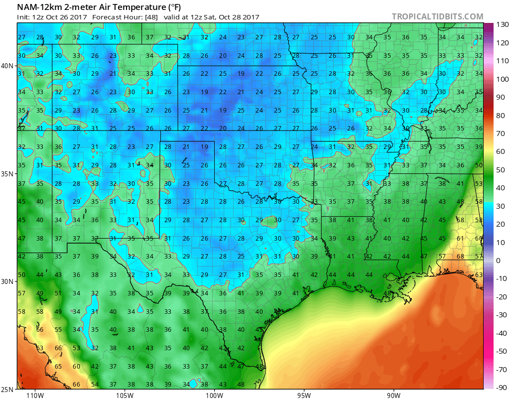
Looks like us in N and E Tx will see temps around 60 prior to the front which looks to clear these areas in the morning. There looks to be some showers associated to the front but they look light until the front moves well SE of this area. Daytime temps will struggle to reach 50 under cloudy skies (there could be some light drizzle, but lower levels will be pretty dry) with gusty north winds. If clouds clear early enough there could be a widespread freeze Saturday morning as shown on the NAM. (Very small chance, but I have to throw it out there :D, of a sleet pellet or two tomorrow afternoon north of I-20)

Image
0 likes   
Follow on Facebook at Ralph's Weather.

User avatar
CaptinCrunch
S2K Supporter
S2K Supporter
Posts: 8728
Age: 57
Joined: Mon Nov 03, 2003 4:33 pm
Location: Kennedale, TX (Tarrant Co.)

Re: Texas Fall 2017

#584 Postby CaptinCrunch » Thu Oct 26, 2017 12:47 pm

Image

Image
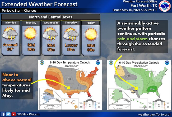
Temperatures late Friday night into Saturday morning are expected to fall into the 30s across all of North and Central Texas. Near and subfreezing temperatures will be possible north and west of a Comanche to Glen Rose to Decatur to Cooper line where a Freeze Watch is in effect. Be sure to protect sensitive plants and vegetation from the freezing temperatures. Areas of frost may also develop.
1 likes   

User avatar
Tireman4
S2K Supporter
S2K Supporter
Posts: 5853
Age: 59
Joined: Fri Jun 30, 2006 1:08 pm
Location: Humble, Texas
Contact:

Re: Texas Fall 2017

#585 Postby Tireman4 » Thu Oct 26, 2017 1:24 pm

CaptinCrunch wrote:Image

Image
Temperatures late Friday night into Saturday morning are expected to fall into the 30s across all of North and Central Texas. Near and subfreezing temperatures will be possible north and west of a Comanche to Glen Rose to Decatur to Cooper line where a Freeze Watch is in effect. Be sure to protect sensitive plants and vegetation from the freezing temperatures. Areas of frost may also develop.


Captin..here we goo........
0 likes   

Brent
S2K Supporter
S2K Supporter
Posts: 38090
Age: 36
Joined: Sun May 16, 2004 10:30 pm
Location: Tulsa Oklahoma
Contact:

Re: Texas Fall 2017

#586 Postby Brent » Thu Oct 26, 2017 1:26 pm

Guess we're gonna find out if that cold Halloween=cold winter verifies... :lol:

This weekend's cold snap alone is really impressive too. I mean last year it took til probably almost Thanksgiving at least to get that cold.

12z Euro has a chilly soaking rain Halloween Afternoon and Night.
2 likes   
#neversummer

User avatar
CaptinCrunch
S2K Supporter
S2K Supporter
Posts: 8728
Age: 57
Joined: Mon Nov 03, 2003 4:33 pm
Location: Kennedale, TX (Tarrant Co.)

Re: Texas Fall 2017

#587 Postby CaptinCrunch » Thu Oct 26, 2017 3:53 pm

Posted on Steve McCauley FB page
https://www.facebook.com/wfaa.steve.mccauley/?hc_ref=ARQJ5e3ghj7WU33_AAZZctYETQT8uBDtFZR-iWLhMuH86TqgUix7XFEq169SdRB9CWI&fref=nf

Say goodbye to the 80s for a few days because a cold front is on the way and will move through the Metroplex between 10 PM and 3 AM tonight. The temperatures do not drastically change immediately after the front passes, but you will notice its passage as winds shift to the north and start gusting to 40 mph. Temperatures will not be able to get out of the 50s tomorrow as the winds slowly relax by late afternoon.

We all fall to the 30s on Saturday morning with the possibiliy of a light freeze to the west, north, and northeast of the Metroplex. The heat island of the immediate DFW area "should" keep temperatures a little above freezing, but if you are in a low-lying area even in the Metroplex, Jack Frost could nip your area as well.

Frost and freeze conditions will shift to the eastern sections of north Texas by Sunday morning, and then it is back to the 70s for Sunday afternoon into Monday with our next cold front due to arrive on Halloween. The Halloween front will actually have moisture to work with, so it looks like a cold rain setting up for late Tuesday into Tuesday night.
:ggreen:
3 likes   

User avatar
Portastorm
Storm2k Moderator
Storm2k Moderator
Posts: 9914
Age: 63
Joined: Fri Jul 11, 2003 9:16 am
Location: Round Rock, TX
Contact:

Re: Texas Fall 2017

#588 Postby Portastorm » Thu Oct 26, 2017 5:02 pm

I can, with confidence, tell you Metroplexers that it will NOT snow tomorrow (Fri) night. Why?

Because Portastorm is Coming to Town!

That's right ... we have a family friend who plays football for SMU and we'll be coming up for the SMU-Tulsa game tomorrow night. I will be prepared to dress warmly but you know how snow and Portastorm don't mix! So don't you worry. I have it covered. :wink:
8 likes   
Any forecasts under my name are to be taken with a grain of salt. Get your best forecasts from the National Weather Service and National Hurricane Center.

Brent
S2K Supporter
S2K Supporter
Posts: 38090
Age: 36
Joined: Sun May 16, 2004 10:30 pm
Location: Tulsa Oklahoma
Contact:

Re: Texas Fall 2017

#589 Postby Brent » Thu Oct 26, 2017 6:03 pm

Portastorm wrote:I can, with confidence, tell you Metroplexers that it will NOT snow tomorrow (Fri) night. Why?

Because Portastorm is Coming to Town!

That's right ... we have a family friend who plays football for SMU and we'll be coming up for the SMU-Tulsa game tomorrow night. I will be prepared to dress warmly but you know how snow and Portastorm don't mix! So don't you worry. I have it covered. :wink:


perhaps some drizzle however

:roflmao:
4 likes   
#neversummer

User avatar
dhweather
S2K Supporter
S2K Supporter
Posts: 6199
Joined: Sat Aug 14, 2004 9:29 pm
Location: Heath, TX
Contact:

Re: Texas Fall 2017

#590 Postby dhweather » Thu Oct 26, 2017 6:10 pm

if there was a CAT 5 IN THE GULF , it wouldn't last very long. This front slams the door on the 2017 Hurricane season, at least for CONUS.
3 likes   
The above post and any post by dhweather is NOT an official forecast and should not be used as such. It is just the opinion of the poster and may or may not be backed by sound meteorological data. It is NOT endorsed by any professional institution including storm2k.org. For official information, please refer to NWS products.

Brent
S2K Supporter
S2K Supporter
Posts: 38090
Age: 36
Joined: Sun May 16, 2004 10:30 pm
Location: Tulsa Oklahoma
Contact:

Re: Texas Fall 2017

#591 Postby Brent » Fri Oct 27, 2017 12:49 am

GFS/CMC both have Halloween as the beginning of a very unsettled pattern with possibly multiple rounds of rainfall to start November. Should be warmer though in the 60s and 70s.
2 likes   
#neversummer

Brent
S2K Supporter
S2K Supporter
Posts: 38090
Age: 36
Joined: Sun May 16, 2004 10:30 pm
Location: Tulsa Oklahoma
Contact:

Re: Texas Fall 2017

#592 Postby Brent » Fri Oct 27, 2017 1:29 am

Euro has almost an inch and a half of rain at DFW Halloween Night into Wednesday morning alone

Then the rest of the run is dry but VERY warm, temperatures well into the 80s lows at night close to 70.
1 likes   
#neversummer

User avatar
CaptinCrunch
S2K Supporter
S2K Supporter
Posts: 8728
Age: 57
Joined: Mon Nov 03, 2003 4:33 pm
Location: Kennedale, TX (Tarrant Co.)

Re: Texas Fall 2017

#593 Postby CaptinCrunch » Fri Oct 27, 2017 9:06 am

Brent wrote:Euro has almost an inch and a half of rain at DFW Halloween Night into Wednesday morning alone

Then the rest of the run is dry but VERY warm, temperatures well into the 80s lows at night close to 70.


What's with the Crazy Euro lately.. :lol:

So far I'm happy with the fact that this Fall isn't a repeat of last year's record smashing warmest Fall. Last October was 6.6 above the monthly mean, and Currently 2017 is only 4.1, but with today and tomorrow looking to be around 10-12 degrees below the daily avg, and Sunday-Tuesday looking to be avg, slightly above, and below avg, I have this October @ +1.7 to close.

November 2016 was even warmer than Oct, and the warmest we got was 88 on the 4th, but I don't see a repeat of last November either. :cheesy:
0 likes   

User avatar
Ntxw
Storm2k Moderator
Storm2k Moderator
Posts: 22785
Joined: Wed Oct 21, 2009 6:34 pm
Location: DFW, Texas

Re: Texas Fall 2017

#594 Postby Ntxw » Fri Oct 27, 2017 9:09 am

CaptinCrunch wrote:
Brent wrote:Euro has almost an inch and a half of rain at DFW Halloween Night into Wednesday morning alone

Then the rest of the run is dry but VERY warm, temperatures well into the 80s lows at night close to 70.


What's with the Crazy Euro lately.. :lol:

So far I'm happy with the fact that this Fall isn't a repeat of last year's record smashing warmest Fall. Last October was 6.6 above the monthly mean, and Currently 2017 is only 4.1, but with today and tomorrow looking to be around 10-12 degrees below the daily avg, and Sunday-Tuesday looking to be avg, slightly above, and below avg, I have this October @ +1.7 to close.

November 2016 was even warmer than Oct, and the warmest we got was 88 on the 4th, but I don't see a repeat of last November either. :cheesy:


I agree with all of this. Euro turned out to be wrong about Halloween on its medium to long range and caved to the GFS. I think the Euro has been too happy with cutoff lows in the Pacific and tries to pump ridging too much ahead of it. Probably some kind of warm up but likely transient in nature.

Dense, cold air will be pooling in Western Canada during this period.

Image

At some point in the coming weeks, I believe the dam will break
3 likes   
The above post and any post by Ntxw is NOT an official forecast and should not be used as such. It is just the opinion of the poster and may or may not be backed by sound meteorological data. It is NOT endorsed by any professional institution including Storm2k. For official information, please refer to NWS products.

  Help support Storm2K!
Help Support Storm2K

Ralph's Weather
S2K Supporter
S2K Supporter
Posts: 3269
Age: 38
Joined: Fri Dec 13, 2013 11:55 am
Location: Lindale, TX
Contact:

Re: Texas Fall 2017

#595 Postby Ralph's Weather » Fri Oct 27, 2017 10:41 am

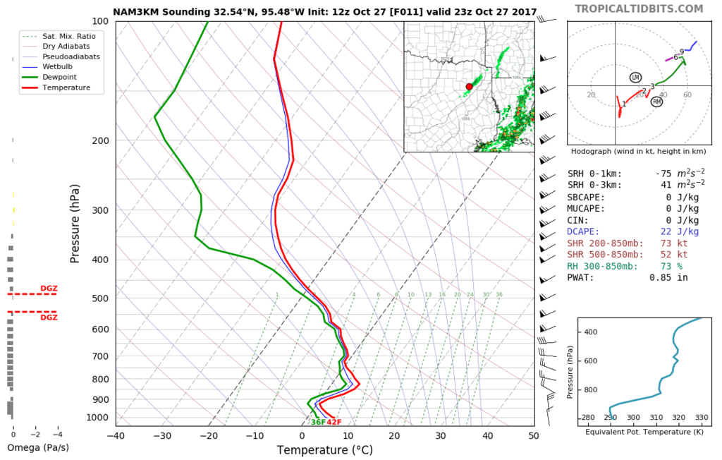
As I mentioned yesterday, some sleet may mix in with the showers today. This will likely be confined to areas west of I-35 and there will be no accumulations. NWS San Angelo mentions this possibility. The low levels are very dry so most of the precip will not reach the ground.

Here is the Skew-T for my house as the line of showers passes through:

Image

Nice to have even a close call this early in the season.
1 likes   
Follow on Facebook at Ralph's Weather.

User avatar
TeamPlayersBlue
Category 5
Category 5
Posts: 3445
Joined: Tue Feb 02, 2010 1:44 am
Location: Denver/Applewood, CO

Re: Texas Fall 2017

#596 Postby TeamPlayersBlue » Fri Oct 27, 2017 11:04 am

What a lovely fall day. We dreamed for days like this over the summer and just last month! Enjoy it fellas.
3 likes   
Personal Forecast Disclaimer:
The posts in this forum are NOT official forecast and should not be used as such. They are just the opinion of the poster and may or may not be backed by sound meteorological data. They are NOT endorsed by any professional institution or storm2k.org. For official information, please refer to the NHC and NWS products.

Yukon Cornelius
S2K Supporter
S2K Supporter
Posts: 1798
Age: 41
Joined: Thu Dec 20, 2012 9:23 pm
Location: Dean, TX/Westcliffe, CO

Re: Texas Fall 2017

#597 Postby Yukon Cornelius » Fri Oct 27, 2017 11:15 am

Currently 44 with a wind chill of 35. Amazing. N wind at 23 with gusts at 32.
2 likes   
#neversummer

Ralph's Weather
S2K Supporter
S2K Supporter
Posts: 3269
Age: 38
Joined: Fri Dec 13, 2013 11:55 am
Location: Lindale, TX
Contact:

Re: Texas Fall 2017

#598 Postby Ralph's Weather » Fri Oct 27, 2017 11:40 am

Several mPING reports of sleet from Abilene and Bridgeport areas.
1 likes   
Follow on Facebook at Ralph's Weather.

Brent
S2K Supporter
S2K Supporter
Posts: 38090
Age: 36
Joined: Sun May 16, 2004 10:30 pm
Location: Tulsa Oklahoma
Contact:

Re: Texas Fall 2017

#599 Postby Brent » Fri Oct 27, 2017 12:03 pm

Ralph's Weather wrote:Several mPING reports of sleet from Abilene and Bridgeport areas.


yeah Fox 4 just reported about sleet out that way too
0 likes   
#neversummer

User avatar
Ntxw
Storm2k Moderator
Storm2k Moderator
Posts: 22785
Joined: Wed Oct 21, 2009 6:34 pm
Location: DFW, Texas

Re: Texas Fall 2017

#600 Postby Ntxw » Fri Oct 27, 2017 12:12 pm

I wouldn't doubt those sleet reports. Some high reflectivity (not thunderstorms) on radar. Temps will likely drop some as it passes by.

Image

0C 850s (freezing above the surface aloft) is dragging just west roughly the Falls to Abilene or so.
0 likes   
The above post and any post by Ntxw is NOT an official forecast and should not be used as such. It is just the opinion of the poster and may or may not be backed by sound meteorological data. It is NOT endorsed by any professional institution including Storm2k. For official information, please refer to NWS products.


  Help support Storm2K!

Help Support Storm2K


Return to “USA & Caribbean Weather”

Who is online

Users browsing this forum: No registered users and 23 guests