ATL: RINA - Post-Tropical
Moderator: S2k Moderators
-
tolakram
- Admin

- Posts: 20178
- Age: 62
- Joined: Sun Aug 27, 2006 8:23 pm
- Location: Florence, KY (name is Mark)
Re: ATL: RINA - Tropical Storm
It's here, just late changing the name.
0 likes
M a r k
- - - - -
Join us in chat: Storm2K Chatroom Invite. Android and IOS apps also available.
The posts in this forum are NOT official forecasts and should not be used as such. Posts are NOT endorsed by any professional institution or STORM2K.org. For official information and forecasts, please refer to NHC and NWS products.
-
CyclonicFury

- Category 5

- Posts: 2032
- Age: 27
- Joined: Sun Jul 02, 2017 12:32 pm
- Location: NC
- Contact:
Re: ATL: RINA - Tropical Storm
Up to 45 kt
AL, 19, 2017110800, , BEST, 0, 346N, 486W, 45, 1000, TS
AL, 19, 2017110800, , BEST, 0, 346N, 486W, 45, 1000, TS
0 likes
NCSU B.S. in Meteorology Class of 2021. Tropical weather blogger at http://www.cyclonicfury.com. My forecasts and thoughts are NOT official, for official forecasts please consult the National Hurricane Center.
-
Sciencerocks
- Category 5
- Posts: 10181
- Age: 40
- Joined: Thu Jul 06, 2017 1:51 am
-
Shell Mound
- Category 5
- Posts: 2432
- Age: 33
- Joined: Thu Sep 07, 2017 3:39 pm
- Location: St. Petersburg, FL → Scandinavia
Re: ATL: RINA - Tropical Storm
The National Hurricane Center seems to be a naming a lot of questionable and/or "borderline" systems recently. Colin, Cindy, Emily, Philippe, Rina...
Not critiquing their expertise, but just pointing out the obvious, which even some Pro Mets have noted.
Not critiquing their expertise, but just pointing out the obvious, which even some Pro Mets have noted.
0 likes
CVW / MiamiensisWx / Shell Mound
The posts in this forum are NOT official forecasts and should not be used as such. They are just the opinion of the poster and may or may not be backed by sound meteorological data. They are NOT endorsed by any professional institution or STORM2K. For official information, please refer to products from the NHC and NWS.
-
Sciencerocks
- Category 5
- Posts: 10181
- Age: 40
- Joined: Thu Jul 06, 2017 1:51 am
Re: ATL: RINA - Tropical Storm
Shell Mound wrote:The National Hurricane Center seems to be a naming a lot of questionable and/or "borderline" systems recently. Colin, Cindy, Emily, Philippe, Rina...
Not critiquing their expertise, but just pointing out the obvious, which even some Pro Mets have noted.
What are you talking about? The nhc named this when it had an well defined LLC and deep convection over the LLC. It was clearly a tropical cyclone. What are they suppose to do? Not upgrade a system that is clearly a nameable system if it doesn't last a full two weeks? I'd feel they were not doing their job if they didn't upgrade this system.
Also Emily was a tropical cyclone. Maybe you should let the pro's do their job. lol
1 likes
-
tolakram
- Admin
- Posts: 20178
- Age: 62
- Joined: Sun Aug 27, 2006 8:23 pm
- Location: Florence, KY (name is Mark)
Re: ATL: RINA - Tropical Storm
Shell Mound wrote:The National Hurricane Center seems to be a naming a lot of questionable and/or "borderline" systems recently. Colin, Cindy, Emily, Philippe, Rina...
Not critiquing their expertise, but just pointing out the obvious, which even some Pro Mets have noted.
It's not obvious to me, all that's obvious is we have better detection tools an they are used, as they should be, to find and monitor tropical storms.
000
WTNT44 KNHC 081443
TCDAT4
Tropical Storm Rina Discussion Number 10
NWS National Hurricane Center Miami FL AL192017
1100 AM AST Wed Nov 08 2017
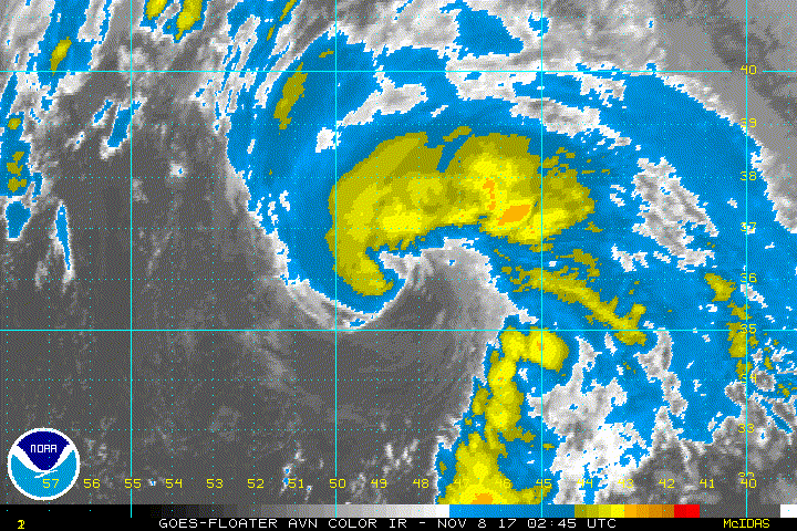
Rina continues to have some subtropical characteristics with
satellite images showing an asymmetric, comma-cloud structure.
Still, AMSU and model analyses are showing the system as moderately
warm core, and there are no signs of fronts near the core. Thus,
Rina will stay as a tropical cyclone, and 50 kt is kept as the
initial wind speed based on the latest satellite estimates. Little
change in strength is expected before Rina loses all deep convection
within the next 24 hours over chilly waters. The system should
become embedded within a frontal zone over the far north Atlantic in
a day or two, and dissipate west of Ireland. No changes were made to
the previous intensity forecast.
The storm is moving northward a bit faster at 18 kt. A continued
acceleration and a turn to the north-northeast is expected overnight
as Rina moves ahead of a shortwave over the Canadian Maritimes. The
cyclone should move quite rapidly to the northeast by late Thursday
and east-northeast on Friday due to strong mid-latitude flow. The
westward guidance trend in the short-term part of the forecast
is still present, and the new NHC prediction is moved in that
direction in the first 24 hours, with little change thereafter.
FORECAST POSITIONS AND MAX WINDS
INIT 08/1500Z 39.4N 48.7W 50 KT 60 MPH
12H 09/0000Z 42.2N 47.8W 50 KT 60 MPH
24H 09/1200Z 47.1N 44.3W 50 KT 60 MPH...POST-TROPICAL
36H 10/0000Z 52.5N 36.0W 50 KT 60 MPH...POST-TROP/EXTRATROP
48H 10/1200Z 55.5N 22.5W 45 KT 50 MPH...POST-TROP/EXTRATROP
72H 11/1200Z...DISSIPATED
$$
Forecaster Blake
WTNT44 KNHC 081443
TCDAT4
Tropical Storm Rina Discussion Number 10
NWS National Hurricane Center Miami FL AL192017
1100 AM AST Wed Nov 08 2017
Rina continues to have some subtropical characteristics with
satellite images showing an asymmetric, comma-cloud structure.
Still, AMSU and model analyses are showing the system as moderately
warm core, and there are no signs of fronts near the core. Thus,
Rina will stay as a tropical cyclone, and 50 kt is kept as the
initial wind speed based on the latest satellite estimates. Little
change in strength is expected before Rina loses all deep convection
within the next 24 hours over chilly waters. The system should
become embedded within a frontal zone over the far north Atlantic in
a day or two, and dissipate west of Ireland. No changes were made to
the previous intensity forecast.
The storm is moving northward a bit faster at 18 kt. A continued
acceleration and a turn to the north-northeast is expected overnight
as Rina moves ahead of a shortwave over the Canadian Maritimes. The
cyclone should move quite rapidly to the northeast by late Thursday
and east-northeast on Friday due to strong mid-latitude flow. The
westward guidance trend in the short-term part of the forecast
is still present, and the new NHC prediction is moved in that
direction in the first 24 hours, with little change thereafter.
FORECAST POSITIONS AND MAX WINDS
INIT 08/1500Z 39.4N 48.7W 50 KT 60 MPH
12H 09/0000Z 42.2N 47.8W 50 KT 60 MPH
24H 09/1200Z 47.1N 44.3W 50 KT 60 MPH...POST-TROPICAL
36H 10/0000Z 52.5N 36.0W 50 KT 60 MPH...POST-TROP/EXTRATROP
48H 10/1200Z 55.5N 22.5W 45 KT 50 MPH...POST-TROP/EXTRATROP
72H 11/1200Z...DISSIPATED
$$
Forecaster Blake
3 likes
M a r k
- - - - -
Join us in chat: Storm2K Chatroom Invite. Android and IOS apps also available.
The posts in this forum are NOT official forecasts and should not be used as such. Posts are NOT endorsed by any professional institution or STORM2K.org. For official information and forecasts, please refer to NHC and NWS products.
- - - - -
Join us in chat: Storm2K Chatroom Invite. Android and IOS apps also available.
The posts in this forum are NOT official forecasts and should not be used as such. Posts are NOT endorsed by any professional institution or STORM2K.org. For official information and forecasts, please refer to NHC and NWS products.
-
HurricaneRyan
- Category 3

- Posts: 846
- Age: 32
- Joined: Sun Dec 05, 2010 3:05 pm
Re: ATL: RINA - Tropical Storm
Here's a fun fact - Rina is now the only R name to officially be used more than once.
Rita and Roxanne were a one and done
Rafael and Richard were only used for the first time this decade
Rene, Rose and Rebekah have yet to be used
Rita and Roxanne were a one and done
Rafael and Richard were only used for the first time this decade
Rene, Rose and Rebekah have yet to be used
2 likes
Kay '22 Hilary '23
-
Sciencerocks
- Category 5
- Posts: 10181
- Age: 40
- Joined: Thu Jul 06, 2017 1:51 am
Re: ATL: RINA - Tropical Storm
000
WTNT44 KNHC 090842
TCDAT4
Tropical Storm Rina Discussion Number 13
NWS National Hurricane Center Miami FL AL192017
500 AM AST Thu Nov 09 2017
It is difficult to depict the presence of a tropical cyclone on
satellite imagery. The previous convection near the possible center
has become completely detached while the circulation is becoming
elongated. In fact, my initial position and intensity are primarily
based on continuity. Rina is over very cold waters and a frontal
system is rapidly approaching the cyclone, so the NHC forecast calls
for Rina to become extratropical during the next 12 hours. Visible
images later this morning will probably help to determine the
structure of Rina if a cyclone exists by then.
Rina or the extratropical low should move fast toward the northeast
and then to the east-northeast within the mid-latitude westerly
flow. Guidance from the NOAA Ocean Prediction Center was use in the
NHC forecast.
FORECAST POSITIONS AND MAX WINDS
INIT 09/0900Z 44.5N 47.0W 40 KT 45 MPH
12H 09/1800Z 49.0N 43.5W 40 KT 45 MPH...POST-TROP/EXTRATROP
24H 10/0600Z 54.0N 32.0W 40 KT 45 MPH...POST-TROP/EXTRATROP
36H 10/1800Z 55.0N 15.0W 40 KT 45 MPH...POST-TROP/EXTRATROP
48H 11/0600Z...DISSIPATED
$$
Forecaster Avila
0 likes
-
weathaguyry

- Category 5
- Posts: 1273
- Age: 22
- Joined: Wed Jun 15, 2016 5:16 am
- Location: Long Island, NY
Re: ATL: RINA - Tropical Storm
From forecaster Blake:
Hopefully Rina will be the finale of the extremely active 2017
Atlantic hurricane season. However that might be wishful thinking
since, of the top 10 most active hurricane seasons before this year,
seven of them still had another tropical storm after today's date.
Hopefully Rina will be the finale of the extremely active 2017
Atlantic hurricane season. However that might be wishful thinking
since, of the top 10 most active hurricane seasons before this year,
seven of them still had another tropical storm after today's date.
1 likes
My posts are only my opinions and NOT official forecasts. For official forecasts, consult the National Hurricane Center or the National Weather Service.
Irene 11', Sandy 12', Fay 20’, Isaias 20’, Elsa 21’, Henri 21’, Ida 21’
Irene 11', Sandy 12', Fay 20’, Isaias 20’, Elsa 21’, Henri 21’, Ida 21’
-
HurricaneBelle

- S2K Supporter

- Posts: 1209
- Joined: Sun Aug 27, 2006 6:12 pm
- Location: Clearwater, FL
Re: ATL: RINA - Tropical Storm
Sciencerocks wrote:Tropical Storm Rina Discussion Number 13
NWS National Hurricane Center Miami FL AL192017
500 AM AST Thu Nov 09 2017
It is difficult to depict the presence of a tropical cyclone on
satellite imagery.
Sounds like it's experiencing Rinal failure.
3 likes
Who is online
Users browsing this forum: No registered users and 18 guests