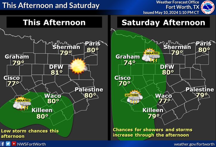
A cold front will move through Central Texas early Wednesday morning, leaving brisk north winds 10 to 15 mph and mostly sunny conditions in it's wake. This will be the coolest day of the week, with many areas struggling into the 50s by afternoon for high temperatures. The wind will make it feel even cooler.
 Short Term
The current weather pattern across the CONUS is defined by a
prominent upper ridge over the western third of the nation with a
large scale trough dominating the rest of the country. This
places North and Central Texas beneath a northwest flow aloft
regime, which is depicted well on satellite by the large steady
fetch of cirrus spilling southeast from the Pacific Northwest.
At the surface, we await the arrival of a cold front currently
stretching across the Central Plains. The front will get a nice
southward push today as a shortwave drops southeast out of
Colorado, with the boundary reaching the Red River early this
afternoon and clearing the southern CWA early this evening. The
strongest pressure rises will occur well behind the initial
frontal passage, so winds will actually be stronger during the
late evening and overnight hours compared to the initial passage
of the cold front.
Temperatures should remain above freezing tonight, but sub-
freezing wind chills are likely during the overnight hours for
areas generally north of I-20 where lows in the mid and upper 30s
will be common, along with wind speeds of 15 to 20 MPH.
Otherwise, some low POPs have been added across the far southeast
counties tonight where post-frontal showers will be possible with
the passage of the shortwave.
Long TermNorth and Central Texas will remain sandwiched between the deep
latitudinal trough over the Eastern CONUS and the upper
ridge over the Western CONUS. A brief transition to breezy
and warmer conditions will occur Friday with occasionally gusty
south winds and mostly-partly sunny skies. After chilly start to
the day Friday morning in the 40s, with a few 30s in protected
areas, highs will rebound quickly well into the 70s most areas as
the Gulf of Mexico remains shut down with a dry airmass hanging
around. By Friday night, the flow aloft will orient northwest as
another shortwave drives southeast across the Mississippi and
Tennessee Valleys. This disturbance will support another reinforcing
cold front through the Southern Plains and our area by Saturday
morning. After a brisk and cool start to the morning, highs should
rebound between 65 and 75 degrees and once again, the bulk of
stronger cold low level advection remains off to the northeast.
Winds should come down by afternoon, as yet another surface high
builds in from the north. Partly sunny conditions will prevail as
periodic rounds of high cloudiness pass across in the progressive
northwest flow aloft.
The high cloudiness should help keep radiational cooling
processes limited somewhat Saturday night, but will still go
cooler than guidance with surface high pressure settling across
the area. Lows will cool rapidly down into the 40s Sunday
morning, with protected areas seeing a few readings down in the
30s. However, as our dry and progressive late Autumn pattern
continues, folks returning from their holiday travels Sunday will
be treated to mostly sunny and slightly above normal temperatures
as the upper pattern dampens with the upper ridge building across
the the region. Highs in the 60s to lower 70s are expected Sunday
afternoon, though the southerly breezes may make it feel a tad
cooler. Low level warm advection and an upper ridge overhead will
lend to breezy and above normal conditions moving into early next
week. Cool mornings between 45 and 55 degrees will modify and warm
quickly into the upper 60s and 70s. Modified moisture will return
northward, but will be shallow with no rainfall expected.