http://www.weather.gov/sju/maria2017

http://www.weather.gov/images/sju/analy ... tivity.gif
Photos of the damage.
http://www.weather.gov/sju/maria2017
Great video from chaser Jose Garcia.
https://www.youtube.com/watch?v=i9intpM ... e=youtu.be
Moderator: S2k Moderators


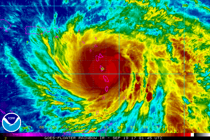
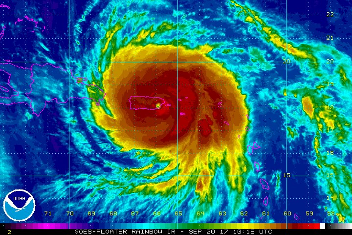
cycloneye wrote:Preliminary data from the NWS of San Juan has Maria making landfall at 155 mph only shy of Cat 5.It will take a few weeks IMO that the final report will be released but we can have good discussions and vote in the poll. Down at the end of post there is a great YouTube video from chaser Jose Garcia from near the landfall area. Poll will be open until December 17 at 8:40 PM AST. Voted yes.
http://www.weather.gov/sju/maria2017
http://www.weather.gov/images/sju/analy ... tivity.gif
Photos of the damage.
http://www.weather.gov/sju/maria2017
Great video from chaser Jose Garcia.
https://www.youtube.com/watch?v=i9intpM ... e=youtu.be


J_J99 wrote:Radar tells a story of a storm getting its act together right at landfall. While not obvious on visible or infared it was obvious on the radar that the EWRC was all but complete. It would not surprise me if it restrengthened slightly back up to a Cat 5 at landfall, losing radar data of the storm at 5:30 am Puerto Rico time made it very difficult to tell what happened to the storm right at landfall (Went out a couple of hours before landfall) but the EWRC was complete and the radar was getting WAY more intense nearing landfall before losing transmission.
Just like IMHO Matthew was near or at CAT 5 intensity at landfall in Haiti, something we will never know for certain. Or how Katrina IMHO was a 130 mph Cat 4 at Buras landfall. I believe reanalysis in the next couple of decades will tell the true story.
But I agree, it was most likely a Cat 5 at landfall.
Alyono wrote:J_J99 wrote:Radar tells a story of a storm getting its act together right at landfall. While not obvious on visible or infared it was obvious on the radar that the EWRC was all but complete. It would not surprise me if it restrengthened slightly back up to a Cat 5 at landfall, losing radar data of the storm at 5:30 am Puerto Rico time made it very difficult to tell what happened to the storm right at landfall (Went out a couple of hours before landfall) but the EWRC was complete and the radar was getting WAY more intense nearing landfall before losing transmission.
Just like IMHO Matthew was near or at CAT 5 intensity at landfall in Haiti, something we will never know for certain. Or how Katrina IMHO was a 130 mph Cat 4 at Buras landfall. I believe reanalysis in the next couple of decades will tell the true story.
But I agree, it was most likely a Cat 5 at landfall.
If Kartina is reanalyzed, the winds will be lowered to 100 kts as that is all the data justified at Buras landfall
J_J99 wrote:Alyono wrote:J_J99 wrote:Radar tells a story of a storm getting its act together right at landfall. While not obvious on visible or infared it was obvious on the radar that the EWRC was all but complete. It would not surprise me if it restrengthened slightly back up to a Cat 5 at landfall, losing radar data of the storm at 5:30 am Puerto Rico time made it very difficult to tell what happened to the storm right at landfall (Went out a couple of hours before landfall) but the EWRC was complete and the radar was getting WAY more intense nearing landfall before losing transmission.
Just like IMHO Matthew was near or at CAT 5 intensity at landfall in Haiti, something we will never know for certain. Or how Katrina IMHO was a 130 mph Cat 4 at Buras landfall. I believe reanalysis in the next couple of decades will tell the true story.
But I agree, it was most likely a Cat 5 at landfall.
If Kartina is reanalyzed, the winds will be lowered to 100 kts as that is all the data justified at Buras landfall
Grand isle on the weak western eyewall of the system was getting cat 3 winds before it stopped recording approximately 1 hour and 45 minutes before the minimum pressure observed. NHC explicitly stated in its post season analysis it could have been a cat 4 right at landfall with cat 4 winds possibly impacting the coast of plaquimines parish but data was too inconclusive with no reliable wind reports near area of first landfall to support 115 kts due to most of them being destroyed.
Alyono wrote:J_J99 wrote:Alyono wrote:
If Kartina is reanalyzed, the winds will be lowered to 100 kts as that is all the data justified at Buras landfall
Grand isle on the weak western eyewall of the system was getting cat 3 winds before it stopped recording approximately 1 hour and 45 minutes before the minimum pressure observed. NHC explicitly stated in its post season analysis it could have been a cat 4 right at landfall with cat 4 winds possibly impacting the coast of plaquimines parish but data was too inconclusive with no reliable wind reports near area of first landfall to support 115 kts due to most of them being destroyed.
Also from the NHC TCR
"The strongest surface (10 m) wind measured by dropwindsonde on the morning of 29
August was 99 kt from two separate sondes. "
The strong winds did not make it to the surface. Kartina seemed to undergo a similar evolution as did Lili
Back to Maria, while it weakened, unfortunately, it kept producing very strong winds at the surface. I do not think that it weakened any further from the 135 kts a few hours before landfall. It's EWRC seemed to have completed just as it was moving onshore. Not enough time for it to regain cat 5 status, however.
J_J99 wrote:Grand isle on the weak western eyewall of the system was getting cat 3 winds before it stopped recording approximately 1 hour and 45 minutes before the minimum pressure observed. NHC explicitly stated in its post season analysis it could have been a cat 4 right at landfall with cat 4 winds possibly impacting the coast of plaquimines parish but data was too inconclusive with no reliable wind reports near area of first landfall to support 115 kts due to most of them being destroyed.
The strongest sustained wind measured from a fixed location at the surface on the morning of 29 August was 76 kt at 0820 UTC by the C-MAN station at Grand Isle, LA. This station’s anemometer, at 16 m elevation, failed at about 0900 UTC, about two hours before closest approach of the eye. The strongest gust from an official reporting station was 99 kt at the Grand Isle C-MAN station at 0838 UTC 29 August, about 2.5 hours prior to the Buras, LA landfall.
cycloneye wrote:Ok folks,Let's not turn this thread to all Katrina as poll is about Maria.


J_J99 wrote:cycloneye wrote:Ok folks,Let's not turn this thread to all Katrina as poll is about Maria.
Sorry bout the unexpected Katrina turn haha.Made a little comment about Katrina didn't know it would turn into a nixe and healthy debate.
You experienced Maria first-hand which must have been a really terrifying experience with how intense it was at landfall. What in your opinion makes it for you most likely a cat 5 at landfall since you experienced and saw the damage firsthand?

cycloneye wrote:J_J99 wrote:cycloneye wrote:Ok folks,Let's not turn this thread to all Katrina as poll is about Maria.
Sorry bout the unexpected Katrina turn haha.
You experienced Maria first-hand which must have been a really terrifying experience with how intense it was at landfall. What in your opinion makes it for you most likely a cat 5 at landfall since you experienced and saw the damage firsthand?
It was horrific where I am in the north coast of PR (San Juan) as it started around 10PM with Tropical Storm force sustained and gusts and around 5 AM the Hurricane force winds arrived to this city. You can tell I didn't slept that night.Those winds lasted around 4 hours and then we were on the back side as the tropical storm winds returned and slowly during that day September 20 they subsided.Also,extreme rains arrived for many hours.

cycloneye wrote:Interesting statement from Stacey Stewart regarding the data made on September 22.
The National Hurricane Center’s Stewart also mentions that many of the island’s weather stations were knocked offline during the storm. So the absolute figures on rainfall and wind speeds are not yet known — and could be even higher than what we already know — and they won’t be known until crews from the National Oceanic and Atmospheric Administration visit these locations.
“Even though the power is out and the [weather stations] weren’t operating in real time, many of these instruments are still recording the data, and we have to go in, retrieve the data, and play it back,” Stewart says.
Also the only two Doppler radar stations on the island are currently offline due to the storm, Stewart says. Doppler radar helps meteorologists make local, community-by-community forecasts. He says it’s unclear if the Doppler radar stations have themselves been damaged or if it was just communications equipment that got toppled over.
Either way, it’s still too early for NOAA crews to go out and inspect, he says.
Whole article at link below.
https://www.vox.com/science-and-health/ ... rain-power
J_J99 wrote:cycloneye wrote:Interesting statement from Stacey Stewart regarding the data made on September 22.
The National Hurricane Center’s Stewart also mentions that many of the island’s weather stations were knocked offline during the storm. So the absolute figures on rainfall and wind speeds are not yet known — and could be even higher than what we already know — and they won’t be known until crews from the National Oceanic and Atmospheric Administration visit these locations.
“Even though the power is out and the [weather stations] weren’t operating in real time, many of these instruments are still recording the data, and we have to go in, retrieve the data, and play it back,” Stewart says.
Also the only two Doppler radar stations on the island are currently offline due to the storm, Stewart says. Doppler radar helps meteorologists make local, community-by-community forecasts. He says it’s unclear if the Doppler radar stations have themselves been damaged or if it was just communications equipment that got toppled over.
Either way, it’s still too early for NOAA crews to go out and inspect, he says.
Whole article at link below.
https://www.vox.com/science-and-health/ ... rain-power
I found this to be very interesting.... the NWS final report from San Juan, did that have all of the information that was missing?


Users browsing this forum: riapal and 181 guests
