Texas Winter 2017-2018

Winter Weather Discussion

Moderator: S2k Moderators

Forum rules

The posts in this forum are NOT official forecast and should not be used as such. They are just the opinion of the poster and may or may not be backed by sound meteorological data. They are NOT endorsed by any professional institution or STORM2K.

Help Support Storm2K
Message
Author
User avatar
SoupBone
Category 5
Category 5
Posts: 3111
Joined: Tue Sep 20, 2005 5:24 pm

Re: Texas Winter 2017-2018

#361 Postby SoupBone » Thu Nov 30, 2017 1:26 pm

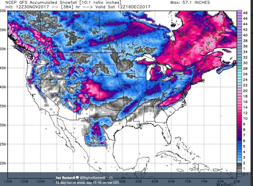
CaptinCrunch wrote:This thread is going to get popping quickly, COLD is coming. The storm system that will effect the southern plains and NTX is hammering the berrin straight right now and as this system moves SE it will continue to gain strength. It's going to drag down a lot of arctic air as it swings across, and I will go out on the limb here and say we get our first official freeze next Thursday or Friday morning.

Don't be surprised if we only see high's in th 40's Thursday/Friday and maybe even Saturday with lows in the 29-32 range for most of DFW and the surrounding counties.


Image
1 likes   
Personal Forecast Disclaimer:
The posts in this forum are NOT official forecast and should not be used as such. They are just the opinion of the poster and may or may not be backed by sound meteorological data. They are NOT endorsed by any professional institution or storm2k.org. For official information, please refer to the NHC and NWS products.

Brent
S2K Supporter
S2K Supporter
Posts: 38090
Age: 36
Joined: Sun May 16, 2004 10:30 pm
Location: Tulsa Oklahoma
Contact:

Re: Texas Winter 2017-2018

#362 Postby Brent » Thu Nov 30, 2017 1:41 pm

Euro is very dry no rain and definitely no snow

Colder for sure mid-week but the core is east of us again
1 likes   
#neversummer

Ralph's Weather
S2K Supporter
S2K Supporter
Posts: 3269
Age: 38
Joined: Fri Dec 13, 2013 11:55 am
Location: Lindale, TX
Contact:

Re: Texas Winter 2017-2018

#363 Postby Ralph's Weather » Thu Nov 30, 2017 1:48 pm

Brent wrote:Euro is very dry no rain and definitely no snow

Colder for sure mid-week but the core is east of us again

For mid- week it will depend on if a piece stays out west or if it all stays in one piece. I think the reinforcing shots after the initial blast will bring chances for snow if there is moisture available. They will be classic examples of NW flow systems where most will likely be dry but one or two will drop a surprisingly large amount of snow with little warning. Once the trough retrogrades west (if it does) then we will have better shots at more widespread precip though precip types will be more questionable.
3 likes   
Follow on Facebook at Ralph's Weather.

aggiecutter
Category 5
Category 5
Posts: 1753
Joined: Thu Oct 14, 2004 9:22 pm
Location: Texarkana

Re: Texas Winter 2017-2018

#364 Postby aggiecutter » Thu Nov 30, 2017 1:50 pm

Yes, this will happen. The pattern screams it.

Image
1 likes   

User avatar
Portastorm
Storm2k Moderator
Storm2k Moderator
Posts: 9914
Age: 63
Joined: Fri Jul 11, 2003 9:16 am
Location: Round Rock, TX
Contact:

Re: Texas Winter 2017-2018

#365 Postby Portastorm » Thu Nov 30, 2017 1:53 pm

Ralph's Weather wrote:
Brent wrote:Euro is very dry no rain and definitely no snow

Colder for sure mid-week but the core is east of us again

For mid- week it will depend on if a piece stays out west or if it all stays in one piece. I think the reinforcing shots after the initial blast will bring chances for snow if there is moisture available. They will be classic examples of NW flow systems where most will likely be dry but one or two will drop a surprisingly large amount of snow with little warning. Once the trough retrogrades west (if it does) then we will have better shots at more widespread precip though precip types will be more questionable.


:uarrow:

THIS!

I think for us it will all be about the trough retrograding. If it does, our chances go way up. If not, it'll be the usual disappointment.
4 likes   
Any forecasts under my name are to be taken with a grain of salt. Get your best forecasts from the National Weather Service and National Hurricane Center.

Brent
S2K Supporter
S2K Supporter
Posts: 38090
Age: 36
Joined: Sun May 16, 2004 10:30 pm
Location: Tulsa Oklahoma
Contact:

Re: Texas Winter 2017-2018

#366 Postby Brent » Thu Nov 30, 2017 1:54 pm

The Euro is pretty much average temps though, nothing really cold here... no colder than it has been already. DFW Is back near 60 Thursday
0 likes   
#neversummer

User avatar
Cpv17
Category 5
Category 5
Posts: 4979
Joined: Wed Dec 07, 2016 2:24 pm
Location: Wharton/El Campo, TX

Re: Texas Winter 2017-2018

#367 Postby Cpv17 » Thu Nov 30, 2017 1:59 pm

Brent wrote:Euro is very dry no rain and definitely no snow

Colder for sure mid-week but the core is east of us again

The Euro could also be struggling with this system. I believe it is right now. That high pressure should drive the colder air right down the Rockies/plains and into TX. From the looks of it right now it looks like the brunt of the cold could be split with one part coming down towards TX associated with the low coming out the southwest and the other part breaking off and going towards the Tennessee Valley. To me it all depends on the low. If it’s there then it should pull down plenty of cold air into it.
Last edited by Cpv17 on Thu Nov 30, 2017 2:04 pm, edited 1 time in total.
0 likes   

orangeblood
S2K Supporter
S2K Supporter
Posts: 3714
Joined: Tue Dec 15, 2009 6:14 pm
Location: Fort Worth, TX

Re: Texas Winter 2017-2018

#368 Postby orangeblood » Thu Nov 30, 2017 2:00 pm

Brent wrote:Euro is very dry no rain and definitely no snow

Colder for sure mid-week but the core is east of us again


Yeah, PNA is forecast WAY too positive next week for us to get much action around here...just glancing blows with core of cold well east. It takes so many variables to align to get very cold in this part of the world, the 3 plus standard deviation PNA is killing us this time while all others appear to be coming into place!!! :froze:
0 likes   

Ralph's Weather
S2K Supporter
S2K Supporter
Posts: 3269
Age: 38
Joined: Fri Dec 13, 2013 11:55 am
Location: Lindale, TX
Contact:

Re: Texas Winter 2017-2018

#369 Postby Ralph's Weather » Thu Nov 30, 2017 2:47 pm

orangeblood wrote:
Brent wrote:Euro is very dry no rain and definitely no snow

Colder for sure mid-week but the core is east of us again


Yeah, PNA is forecast WAY too positive next week for us to get much action around here...just glancing blows with core of cold well east. It takes so many variables to align to get very cold in this part of the world, the 3 plus standard deviation PNA is killing us this time while all others appear to be coming into place!!! :froze:

If the PNA does go crazy high then I agree. I am not sold that it will do so though. See below for my reasoning. The PNA has tended to stay on the low side of the ensemble forecasts at all ranges. Also a tanking -AO along with a neutral to slightly -NAO tends to result in a more centrally located mean trough.

Image
0 likes   
Follow on Facebook at Ralph's Weather.

Brent
S2K Supporter
S2K Supporter
Posts: 38090
Age: 36
Joined: Sun May 16, 2004 10:30 pm
Location: Tulsa Oklahoma
Contact:

Re: Texas Winter 2017-2018

#370 Postby Brent » Thu Nov 30, 2017 2:51 pm

lol the Euro is in the 70s next Saturday. The GFS stays on the cold side.
0 likes   
#neversummer

User avatar
bubba hotep
S2K Supporter
S2K Supporter
Posts: 5837
Joined: Wed Dec 28, 2016 1:00 am
Location: Collin County Texas

Re: Texas Winter 2017-2018

#371 Postby bubba hotep » Thu Nov 30, 2017 2:53 pm

Brent wrote:The Euro is pretty much average temps though, nothing really cold here... no colder than it has been already. DFW Is back near 60 Thursday


12z Euro is a train wreck! No rain and 5 days above 70 including the 9th of Dec.
0 likes   
Winter time post are almost exclusively focused on the DFW area.

Brent
S2K Supporter
S2K Supporter
Posts: 38090
Age: 36
Joined: Sun May 16, 2004 10:30 pm
Location: Tulsa Oklahoma
Contact:

Re: Texas Winter 2017-2018

#372 Postby Brent » Thu Nov 30, 2017 2:55 pm

bubba hotep wrote:
Brent wrote:The Euro is pretty much average temps though, nothing really cold here... no colder than it has been already. DFW Is back near 60 Thursday


12z Euro is a train wreck! No rain and 5 days above 70 including the 9th of Dec.


a LOW of 67 and high of 82 Monday. I am so tired of record highs

Just once I want to set a record low... but that'll probably take a miracle.
Last edited by Brent on Thu Nov 30, 2017 3:01 pm, edited 1 time in total.
0 likes   
#neversummer

aggiecutter
Category 5
Category 5
Posts: 1753
Joined: Thu Oct 14, 2004 9:22 pm
Location: Texarkana

Re: Texas Winter 2017-2018

#373 Postby aggiecutter » Thu Nov 30, 2017 2:59 pm

Ralph's Weather wrote:If the PNA does go crazy high then I agree. I am not sold that it will do so though. See below for my reasoning. The PNA has tended to stay on the low side of the ensemble forecasts at all ranges. Also a tanking -AO along with a neutral to slightly -NAO tends to result in a more centrally located mean trough.

Image


:uarrow:
0 likes   

Ralph's Weather
S2K Supporter
S2K Supporter
Posts: 3269
Age: 38
Joined: Fri Dec 13, 2013 11:55 am
Location: Lindale, TX
Contact:

Re: Texas Winter 2017-2018

#374 Postby Ralph's Weather » Thu Nov 30, 2017 3:01 pm

Brent wrote:
bubba hotep wrote:
Brent wrote:The Euro is pretty much average temps though, nothing really cold here... no colder than it has been already. DFW Is back near 60 Thursday


12z Euro is a train wreck! No rain and 5 days above 70 including the 9th of Dec.


a LOW of 67 and high of 82 Monday. I am so tired of record highs

I would not be surprised at all by 80s in western N TX ahead of the strong front. Eastern areas will hopefully see some clouds and showers developing to mitigate warming to just the low 70s.
0 likes   
Follow on Facebook at Ralph's Weather.

User avatar
TeamPlayersBlue
Category 5
Category 5
Posts: 3445
Joined: Tue Feb 02, 2010 1:44 am
Location: Denver/Applewood, CO

Re: Texas Winter 2017-2018

#375 Postby TeamPlayersBlue » Thu Nov 30, 2017 3:42 pm

I think the Euro is too far east with the ridge in the NW territories. We will see.
0 likes   
Personal Forecast Disclaimer:
The posts in this forum are NOT official forecast and should not be used as such. They are just the opinion of the poster and may or may not be backed by sound meteorological data. They are NOT endorsed by any professional institution or storm2k.org. For official information, please refer to the NHC and NWS products.

orangeblood
S2K Supporter
S2K Supporter
Posts: 3714
Joined: Tue Dec 15, 2009 6:14 pm
Location: Fort Worth, TX

Re: Texas Winter 2017-2018

#376 Postby orangeblood » Thu Nov 30, 2017 4:00 pm

TeamPlayersBlue wrote:I think the Euro is too far east with the ridge in the NW territories. We will see.


Any particularly reason why you think this or just a wild guess ?
0 likes   

User avatar
Ntxw
Storm2k Moderator
Storm2k Moderator
Posts: 22785
Joined: Wed Oct 21, 2009 6:34 pm
Location: DFW, Texas

Re: Texas Winter 2017-2018

#377 Postby Ntxw » Thu Nov 30, 2017 4:10 pm

orangeblood wrote:
TeamPlayersBlue wrote:I think the Euro is too far east with the ridge in the NW territories. We will see.


Any particularly reason why you think this or just a wild guess ?


It may have a tendency to retrograde west. Perhaps initially might be east but background Nina forcing is Aleutian ridge evident by warmer SST the past 2-3 months below the Aleutians. In time it will move back as -AAM takes over again
1 likes   
The above post and any post by Ntxw is NOT an official forecast and should not be used as such. It is just the opinion of the poster and may or may not be backed by sound meteorological data. It is NOT endorsed by any professional institution including Storm2k. For official information, please refer to NWS products.

  Help support Storm2K!
Help Support Storm2K

Ralph's Weather
S2K Supporter
S2K Supporter
Posts: 3269
Age: 38
Joined: Fri Dec 13, 2013 11:55 am
Location: Lindale, TX
Contact:

Re: Texas Winter 2017-2018

#378 Postby Ralph's Weather » Thu Nov 30, 2017 4:13 pm

Tomorrow we will begin to have the NAm's assistance to determine near surface timing and temps. As of now, the end of the NAM 18Z run (Sunday night) looks very similar to the GFS. The GFS digs the tail end of the trough across the SW early next week while the Euro leaves the SW end behind off of CA where it just dies off while the main trough jets east. If I recall this is a bias of the Euro. The Canadian is very similar to the GFS though a bit faster, the main trough drags the SW end across the SW. The Japanese is more like the Euro. The Navy is a combo of the GFS/Canadian and Euro, it follows the GFS path through Monday but it cuts off the SW end which then slowly moves into TX by late week.

I have never paid much attention to the Navy model, but it closely matches what I expect the 500mb to look like next week.
0 likes   
Follow on Facebook at Ralph's Weather.

Brent
S2K Supporter
S2K Supporter
Posts: 38090
Age: 36
Joined: Sun May 16, 2004 10:30 pm
Location: Tulsa Oklahoma
Contact:

Re: Texas Winter 2017-2018

#379 Postby Brent » Thu Nov 30, 2017 4:57 pm

Really good AFD from FWD

The extend part of the forecast continues to advertise a pattern
change that will end the warm spell and bring us a prolonged
period of near normal temperatures. However, the various model
guidance continues to display an unusually large amount of
variance from run to run and each other. The differences are a
result of how the models handle the PV anomaly that drops into the
western part of the trough Tuesday. Some solutions keep a sharp
positive tilt upper trough that moves from northwest to southeast
across the country while others break off the energy into a closed
low and either move it out into the Pacific and leave it there or
eventually bring it eastward. In any case, the evolution of the
upper trough is critical to both just how much cold air makes it
into the region and our rain chances (especially behind the
front).

The reason why the evolution of the trough is so critical to the
temperature forecast in this pattern, is because the center of the
trough will be positioned to our east, meaning we and the Plains
are on the backside where subsidence and warming off of the Rocky
Mountains will be tremendous. Shift that trough a few hundred
miles farther west, and the subsidence warming will not impact the
source region of our air and it will be colder.
On today`s set of
model runs, it is the GFS that is the coldest, while the ECMWF
and Canadian are much warmer. These models have all been trading
places the last few days.

So what we DO know is that the front looks like it will arrive
Tuesday morning with temperatures dropping into the 50s during the
day behind it. There will be a good chance of rain along and just
behind the front as moisture and instability look sufficient for
some scattered convection to develop. There could even be an
isolated thunderstorm too. Lows will likely fall into the 30s or
40s by Tuesday night, but this will depend on whether we clear out
or not.

The GFS, with more troughing farther west than all of the other
models today, does show a second wave of isentropic lift behind
the front Tuesday night and Wednesday which would result in some
precipitation well behind front. Because this solution is
plausible will show some low chances of rain, but since this lift
occurs at a fairly high level of the atmosphere where moisture
quantity is limited, it would keep QPF very low and less than
0.10". The GFS also does indicate rain changing to snow where
precipitation is heavy enough because the airmass it shows is very
cold aloft. It is the warm air in the lowest 5000 feet of the
atmosphere that is the missing ingredient to get worried about a
snow event. That`s not to say that snow flakes would not be
possible, but we would have to rely upon the cooling effects of
latent heat absorption from melting/evaporating precipitation to
get surface temperatures cold enough for snow to reach the ground.
In other words, the chance of seeing snow is a long shot that
relies on precipitation intensity since the low levels just don`t
look cold enough in a traditional sense. Furthermore the chance
of this being a snow event with impacts to society are just barely
above zero, so there is really no reason to get worried about it.


Chances of rain will certainly end by Wednesday night as all model
solutions by this time show the lift ending and/or dry air in
place. Temperatures should be cool, but essentially near normal
for the time of year
. Again model forecasts are showing a lot of
spread but will split the difference with lows in the 30 and highs
in the 50s to end next week.
0 likes   
#neversummer

User avatar
South Texas Storms
Professional-Met
Professional-Met
Posts: 4226
Joined: Thu Jun 24, 2010 12:28 am
Location: Houston, TX

Re: Texas Winter 2017-2018

#380 Postby South Texas Storms » Thu Nov 30, 2017 5:14 pm

Unfortunately the 18z GFS looks much more like the Euro now and is much drier. More progressive pattern leads to no leftover energy in the SW US.
1 likes   


Return to “Winter Weather”

Who is online

Users browsing this forum: No registered users and 19 guests