Texas Winter 2017-2018

Winter Weather Discussion

Moderator: S2k Moderators

Forum rules

The posts in this forum are NOT official forecast and should not be used as such. They are just the opinion of the poster and may or may not be backed by sound meteorological data. They are NOT endorsed by any professional institution or STORM2K.

Help Support Storm2K
Message
Author
Ralph's Weather
S2K Supporter
S2K Supporter
Posts: 3269
Age: 38
Joined: Fri Dec 13, 2013 11:55 am
Location: Lindale, TX
Contact:

Re: Texas Winter 2017-2018

#641 Postby Ralph's Weather » Tue Dec 05, 2017 4:08 pm

Ntxw wrote:It's interesting that this system the northern part of the state is not seeing much action, because it is too cold aloft and everything is further south along the boundary of warm and cold

If everything was not consolidated down over Mexico and the Gulf Fri could have been really interesting across N TX possibly. Even still you have to wonder if there is any chance for this strong vorticity to bring its own moisture. Best chance for seeing something would likely be in NW TX. I could see this bringing some surprise decent snows to the NM mountains.
0 likes   
Follow on Facebook at Ralph's Weather.

Ralph's Weather
S2K Supporter
S2K Supporter
Posts: 3269
Age: 38
Joined: Fri Dec 13, 2013 11:55 am
Location: Lindale, TX
Contact:

Re: Texas Winter 2017-2018

#642 Postby Ralph's Weather » Tue Dec 05, 2017 4:09 pm

weatherdude1108 wrote:I saw James Spann on his blog today mentioning how you would normally see severe weather along the front this time of year nearing Winter with such drastic change in air masses, but it's not the case this time, with just general thunder along it (talking about the Alabama area). He didn't question or explain why no severe weather, just mentioned it. Thought it was interesting. I wish he were in Texas. It's great to listen to his forecasts.

I listened to him daily in college and that is how I learned to read models.
1 likes   
Follow on Facebook at Ralph's Weather.

User avatar
horselattitudesfarm
Category 1
Category 1
Posts: 315
Joined: Thu Jul 16, 2009 5:55 pm
Location: Asheville, NC (formerly from Dallas, TX)

Re: Texas Winter 2017-2018

#643 Postby horselattitudesfarm » Tue Dec 05, 2017 4:27 pm

wxman57 wrote:
Tireman4 wrote:
wxman57 wrote:My 294-298 day outlook indicates a massive surge of Arctic air moving south into the Plains states just before Christmas. It's all coming together for a major winter storm around Christmas.

http://i63.tinypic.com/iojd6h.jpg


Oh now you are just taunting. Sigh.


No, next winter, I promise, I'll be wishing for cold, snowy weather. I'll even change my avatar for next winter.

Is WXMAN going to be right on his Feb 28th prediction?
0 likes   

User avatar
TeamPlayersBlue
Category 5
Category 5
Posts: 3445
Joined: Tue Feb 02, 2010 1:44 am
Location: Denver/Applewood, CO

Re: Texas Winter 2017-2018

#644 Postby TeamPlayersBlue » Tue Dec 05, 2017 4:31 pm

wxman57 wrote:One thing to watch for as far as snow in south Texas is the formation of a west Gulf low. This is a low that forms on the cold front off the TX coast. The key to the formation of the low is the 500mb vorticity max reaching west Texas. As a general rule of thumb, when the 500mb vort max reaches El Paso, the west Gulf low forms. This is indicated in the graphic below. Now this doesn't mean we'll always get snow, as one vital component is sub-freezing air in the lower few thousand feet. It's a very delicate balance. If the low forms too close to the coast, then the surface air will not be cold enough for snow. If the low forms too far offshore (like with the ECMWF), then we have the cold air but no precip.

Given the quite warm coastal water temps, I think that this will be a cold rain event for coastal counties. Maybe very little precip at all Thursday night. The precip may fall from about 10-15 thousand feet up and evaporate before reaching the ground.

Image


What dynamics are most important for the low to form? In this case, with the vort max out west, would it be upper level divergence or positive vorticity in the region? Thank you for your input!

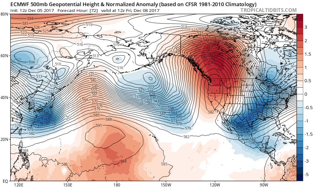
I dont want to beat the snow drum too too much, but look at this setup. This is the Euro for Fri, if you told me it snowed from this setup, i would 100% believe you. Im all for it.
Image
0 likes   
Personal Forecast Disclaimer:
The posts in this forum are NOT official forecast and should not be used as such. They are just the opinion of the poster and may or may not be backed by sound meteorological data. They are NOT endorsed by any professional institution or storm2k.org. For official information, please refer to the NHC and NWS products.

Cheyenne ridge
Tropical Low
Tropical Low
Posts: 17
Age: 49
Joined: Tue Nov 29, 2016 5:15 pm
Location: Cheyenne, Wyoming

Re: Texas Winter 2017-2018

#645 Postby Cheyenne ridge » Tue Dec 05, 2017 4:41 pm

Looks to be some very cold air building in NW Canada in about 10 days that may slide south.Fingers crossed.Make Wyoming cold again!!
2 likes   

Tejas89
Category 1
Category 1
Posts: 429
Joined: Mon Dec 28, 2009 9:25 pm
Location: DFW, TX

Re: Texas Winter 2017-2018

#646 Postby Tejas89 » Tue Dec 05, 2017 4:45 pm

Winter storm warning for Davis mountains.

Image
2 likes   

User avatar
Ntxw
Storm2k Moderator
Storm2k Moderator
Posts: 22785
Joined: Wed Oct 21, 2009 6:34 pm
Location: DFW, Texas

Re: Texas Winter 2017-2018

#647 Postby Ntxw » Tue Dec 05, 2017 4:53 pm

TeamPlayersBlue wrote:What dynamics are most important for the low to form? In this case, with the vort max out west, would it be upper level divergence or positive vorticity in the region? Thank you for your input!

I dont want to beat the snow drum too too much, but look at this setup. This is the Euro for Fri, if you told me it snowed from this setup, i would 100% believe you. Im all for it.
http://i47.photobucket.com/albums/f192/TeamPlayersblue/ecmwf_z500aNorm_npac_4_zpswr8ej6wg.png


The set up is quite interesting. Most guidance keep it positive tilt (trough leaning Northeast to southwest) until it swings out of Texas. If it takes a more neutral/negative tilt (North to South or Northwest to Southeast) like in December 2004 then it would be a bigger event. Both scenarios kind of start the same but modeled to diverge once exiting the big bend of Texas.


Image
0 likes   
The above post and any post by Ntxw is NOT an official forecast and should not be used as such. It is just the opinion of the poster and may or may not be backed by sound meteorological data. It is NOT endorsed by any professional institution including Storm2k. For official information, please refer to NWS products.

  Help support Storm2K!
Help Support Storm2K

Snowman67
Category 2
Category 2
Posts: 633
Joined: Thu Dec 31, 2009 12:44 pm
Location: Tomball, TX

Re: Texas Winter 2017-2018

#648 Postby Snowman67 » Tue Dec 05, 2017 4:55 pm

Cheyenne ridge wrote:Looks to be some very cold air building in NW Canada in about 10 days that may slide south.Fingers crossed.Make Wyoming cold again!!


Where are you seeing this? Can you pass along a link? Would be nice to see some cold air building up there. Thanks.
0 likes   
Any forecast I make is based on my opinion only. Please refer to the NWS or NHC for official forecasts.

User avatar
Tireman4
S2K Supporter
S2K Supporter
Posts: 5853
Age: 59
Joined: Fri Jun 30, 2006 1:08 pm
Location: Humble, Texas
Contact:

Re: Texas Winter 2017-2018

#649 Postby Tireman4 » Tue Dec 05, 2017 4:55 pm

000
FXUS64 KHGX 052108
AFDHGX

Area Forecast Discussion
National Weather Service Houston/Galveston TX
308 PM CST Tue Dec 5 2017

.DISCUSSION...
A cold front has pushed through SE TX and is entering the Gulf of
Mexico. A tight pressure gradient behind the front will bring a
strong NNE wind behind the front. It might be overkill but think
sustained winds along the immediate coast will reach 20-25 mph
with higher gusts and decided to go ahead and issue a Wind
Advisory. The strongest winds/greatest impact will likely remain
close to the coast. A series of weak upper level disturbances will
traverse the state over the next 36-42 hours and coupled with
weak isentropic upglide will yield periods of light rain. Rain is
expected to redevelop between 03-06z and expand in coverage by
09z. Would not be surprised if a few ice pellets mixed in with the
rain north of a Caldwell to Trinity line at the onset due to some
evaporative cooling and a low wet bulb temperature. Periods of
rain will continue on Wednesday as another disturbance crosses the
region. Temperatures will be cold with thick cloud cover, weak
cold air advection and precipitation. Doubt there will be of a
diurnal range in temperatures. Forecast soundings show a nearly
saturated profile on Wednesday so some moderate rainfall totals
are likely.

The GFS and ECMWF differ a bit with how long the precipitation
hangs around SE TX. The ECMWF is a bit more amplified in the upper
keeping more of a SW wind aloft Wed night into Thursday while the
GFS is more zonal. The GFS allows for a bit more low level drying
as well. The GFS has been trending toward the more aggressive
ECMWF so feel it`s best to increase rain chances through Wednesday
night and maintain a chance for precip into Thursday. A messy
forecast gets even messier as we move into Wednesday night.
Forecast soundings show a saturated profile above 8000 feet, The
thermal profile falls below 0 C so there could be some mixture of
rain and snow Wednesday night over the extreme north. First guess,
some mixed precip could occur north of a Caldwell to Trinity line.
1000-850 and 850-700 thickness values are marginally supportive of
a rain-snow mix but the forecast soundings for KCLL and
Madisonville look more favorable for snow. Surface temperatures
will remain relatively warm through Thursday, well above freezing
and there is a large chunk of dry air that the precip will have to
fall through, likely evaporating before reaching the ground. There
is a lot of uncertainty this far out so would prefer to keep the
precip type in the grids as rain for now and see if models come
into better agreement.

Drier air will gradually filter into the region from the north on
Thursday but light rain will probably linger near the coast and
toward the southern edge of the CWA. Clouds will limit heating on
Thursday and high temperatures will struggle to warm into the
middle 50`s. The upper level trough axis finally shifts east of
SE TX on Friday and any residual precipitation should end early
Friday as dry air continues to filter into the area. Sunshine is
expected to return by Friday afternoon.

The weekend and first half of next week look quiet with
seasonable temperatures and no precipitation expected. 43

&&

.MARINE...
The passage of an afternoon cold front will strengthen northerly
winds and allow seas to build through early Wednesday. The delay of
colder air over much warmer waters late Wednesday into early
Thursday...as it relates to tonight into early Wednesday`s
tight offshore pressure gradient...will likely just maintain
Advisory level winds. Tomorrow`s Gulf winds may occasionally gust to
gale thus had left the Gale Watch up...now in effect for the 20 to
60 nm waters from sunrise tomorrow morning through tomorrow
afternoon. Generally 20 to 25 knot bay winds with 20 to 30 knots
sustained winds over the Gulf from tonight through late Thursday.
Agitated seas will likely reach average 5 to 7 feet nearshore
heights...7 to 10 feet offshore. Winds and seas will begin to come
down Friday. Periods of long duration light rain on both Wednesday
and Thursday. Winds and seas will begin to fall on Friday. High
pressure settling in over the waters this weekend will produce a
significantly weakened light offshore flow pattern and average 2 to
3 foot sea heights. 31

&&

.PRELIMINARY POINT TEMPS/POPS...
College Station (CLL) 41 46 39 53 33 / 80 100 60 30 10
Houston (IAH) 44 45 42 52 36 / 80 100 80 40 20
Galveston (GLS) 48 51 46 53 43 / 80 100 70 70 40

&&

.HGX WATCHES/WARNINGS/ADVISORIES...
TX...Wind Advisory from 6 PM this evening to 9 AM CST Wednesday for
the following zones: Brazoria...Chambers...Galveston...
Matagorda.

GM...Small Craft Advisory until 6 AM CST Thursday for the following
zones: Coastal waters from Freeport to the Matagorda Ship
Channel out 20 NM...Coastal waters from High Island to
Freeport out 20 NM...Galveston Bay...Matagorda Bay.

Gale Watch from Wednesday morning through late Wednesday night
for the following zones: Waters from Freeport to the
Matagorda Ship Channel from 20 to 60 NM...Waters from High
Island to Freeport from 20 to 60 NM.

Small Craft Advisory until 6 AM CST Wednesday for the following
zones: Waters from Freeport to the Matagorda Ship Channel
from 20 to 60 NM...Waters from High Island to Freeport from
20 to 60 NM.

&&

$$

Discussion...43
0 likes   

User avatar
Ntxw
Storm2k Moderator
Storm2k Moderator
Posts: 22785
Joined: Wed Oct 21, 2009 6:34 pm
Location: DFW, Texas

Re: Texas Winter 2017-2018

#650 Postby Ntxw » Tue Dec 05, 2017 4:58 pm

Both the GFS MOS and NAM MOS has a pretty good freeze at DFW (upper 20s in the latter). So barring some kind of warm pocket, you can mark your Calendars to end the streak :lol:
1 likes   
The above post and any post by Ntxw is NOT an official forecast and should not be used as such. It is just the opinion of the poster and may or may not be backed by sound meteorological data. It is NOT endorsed by any professional institution including Storm2k. For official information, please refer to NWS products.


  Help support Storm2K!

Help Support Storm2K


User avatar
Portastorm
Storm2k Moderator
Storm2k Moderator
Posts: 9914
Age: 63
Joined: Fri Jul 11, 2003 9:16 am
Location: Round Rock, TX
Contact:

Re: Texas Winter 2017-2018

#651 Postby Portastorm » Tue Dec 05, 2017 4:59 pm

Nice discussion out of NWSFO Austin/San Antonio this afternoon. Good read:

https://mesonet.agron.iastate.edu/wx/afos/p.php?pil=AFDEWX&e=201712052155
2 likes   
Any forecasts under my name are to be taken with a grain of salt. Get your best forecasts from the National Weather Service and National Hurricane Center.

User avatar
Rgv20
S2K Supporter
S2K Supporter
Posts: 2466
Age: 38
Joined: Wed Jan 05, 2011 5:42 pm
Location: Edinburg/McAllen Tx

Re: Texas Winter 2017-2018

#652 Postby Rgv20 » Tue Dec 05, 2017 5:03 pm

Rare to see an afternoon NWS Brownsville discussion with a mention of Snow... :double:

.LONG TERM (Thursday through Tuesday): Isentropic upglide
continues on Thursday, continuing to produce light rain and
drizzle areawide through the day. CAA and low clouds will keep
temperatures well below normal, struggling to reach 50 degrees
even during the afternoon. The weather gets a little more
interesting Thursday night. After midnight, the large-scale H5
trough drives southward across Texas. There is a considerable cold
core with this trough aloft, with the freezing level dropping to
1500 to 2000 feet overnight during passage. During this time,
rainfall will still be falling across the area, as mixture and
instability are still high. With wet bulb effects minimizing some
melting, would not be surprised to see some -SN mixing in with
the -RA in the northwest Ranchlands, areas that will have the
smallest distance between the freezing level and the surface. Now
with the limited amount of time of potential -SN and still warm
ground conditions, expect only a dusting of snow, with no
accumulation. Now subtle timing differences are leading to very
different solutions on the non- liquid precip, generally relating
to how fast the trough axis sweeps through. GFS remains the
fastest with the trough, drying things out Thursday night, while
EC, Canadian, and NAM are step things back slowly Thursday night.
Seeing that the GFS is initializing the cold air mass poorly
already, will shy away from the faster progression, keeping closer
to the slower EC prognosis (and associated -SN to the north).

With the slower progression, will hold on to precipitation chances
into the day Friday, with temperatures continuing to struggle to
rise until late in the afternoon once some cloud breaks start to
arrive. Drier airmass arrives in earnest Saturday morning, with
clear skies expected all weekend. Northerly flow continues to keep
a tap of cooler air sweeping through the region, so highs will
only reach the 60s both afternoons.
1 likes   
The following post is NOT an official forecast and should not be used as such. It is just the opinion of the poster and may or may not be backed by sound meteorological data. It is NOT endorsed by any professional institution including storm2k.org For Official Information please refer to the NHC and NWS products.

User avatar
TeamPlayersBlue
Category 5
Category 5
Posts: 3445
Joined: Tue Feb 02, 2010 1:44 am
Location: Denver/Applewood, CO

Re: Texas Winter 2017-2018

#653 Postby TeamPlayersBlue » Tue Dec 05, 2017 5:06 pm

Ntxw wrote:
TeamPlayersBlue wrote:What dynamics are most important for the low to form? In this case, with the vort max out west, would it be upper level divergence or positive vorticity in the region? Thank you for your input!

I dont want to beat the snow drum too too much, but look at this setup. This is the Euro for Fri, if you told me it snowed from this setup, i would 100% believe you. Im all for it.
http://i47.photobucket.com/albums/f192/TeamPlayersblue/ecmwf_z500aNorm_npac_4_zpswr8ej6 wg.png


The set up is quite interesting. Most guidance keep it positive tilt (trough leaning Northeast to southwest) until it swings out of Texas. If it takes a more neutral/negative tilt (North to South or Northwest to Southeast) like in December 2004 then it would be a bigger event. Both scenarios kind of start the same but modeled to diverge once exiting the big bend of Texas.

http://i68.tinypic.com /2vae15k.gif

http://i68.tinypic.com /11u8gn7.gif


Dont you dare post that analog!

I did notice it had some similarities with that event. A piece would need to break off i think. Some pretty low heights over SE Tx. Not often heights get this low, even in the coldest cold snaps.
0 likes   
Personal Forecast Disclaimer:
The posts in this forum are NOT official forecast and should not be used as such. They are just the opinion of the poster and may or may not be backed by sound meteorological data. They are NOT endorsed by any professional institution or storm2k.org. For official information, please refer to the NHC and NWS products.

User avatar
South Texas Storms
Professional-Met
Professional-Met
Posts: 4226
Joined: Thu Jun 24, 2010 12:28 am
Location: Houston, TX

Re: Texas Winter 2017-2018

#654 Postby South Texas Storms » Tue Dec 05, 2017 5:16 pm

Portastorm wrote:Nice discussion out of NWSFO Austin/San Antonio this afternoon. Good read:

https://mesonet.agron.iastate.edu/wx/afos/p.php?pil=AFDEWX&e=201712052155


It sure was a great one this afternoon. Jared Allen wrote it. He writes kinda similar to how Dennis Cavanaugh wrote such detailed AFDs for DFW before he left to Little Rock a few years ago.
2 likes   

Ralph's Weather
S2K Supporter
S2K Supporter
Posts: 3269
Age: 38
Joined: Fri Dec 13, 2013 11:55 am
Location: Lindale, TX
Contact:

Re: Texas Winter 2017-2018

#655 Postby Ralph's Weather » Tue Dec 05, 2017 5:23 pm

I am going to watch the front for this time next week. GFS is slowly trending it west just like the current front was modeled to stay east of us as of last Thursday.
0 likes   
Follow on Facebook at Ralph's Weather.

User avatar
Cpv17
Category 5
Category 5
Posts: 4979
Joined: Wed Dec 07, 2016 2:24 pm
Location: Wharton/El Campo, TX

Re: Texas Winter 2017-2018

#656 Postby Cpv17 » Tue Dec 05, 2017 5:32 pm

Ralph's Weather wrote:I am going to watch the front for this time next week. GFS is slowly trending it west just like the current front was modeled to stay east of us as of last Thursday.


I was thinking the same thing.
0 likes   

User avatar
cctxhurricanewatcher
Category 5
Category 5
Posts: 1206
Joined: Sun Sep 12, 2004 8:53 pm
Location: Corpus Christi, Texas

Re: Texas Winter 2017-2018

#657 Postby cctxhurricanewatcher » Tue Dec 05, 2017 5:34 pm

From the NWS Corpus Forecast Discussion..


The complexity of the forecast changes greatly late Thursday night
into early Friday morning. Never thought of much mixed phase
precipitation in South Texas but here we are. Definitely not a lock
by any means but thermal and mass fields off the SREF/NAM/EC do
support a brief period of light snow or rain/snow mixture occurring
early Friday morning across the Brush Country and maybe as far east
as Corpus Christi. This is all tied to the approach of the mid-level
trough/cold pool with the help of dynamically cooling the column
with each passing shortwave trough, some precipitation loading and
eventual wet bulbing within the boundary layer to make it all
possible. The freezing level also does drop below 2000 feet in
places. This is a relatively rare event, snow in general is
relatively rare in South Texas, but we are forecasting any
accumulations at this time. Even with boundary layer temperatures in
the mid-30s, surface temperatures are expected to be well above
freezing, as are the road surfaces, so sticking doesn`t seem too
likely. Farther north, around Victoria, the profile isn`t as
saturated with a little less ice in the cloud, and a warmer boundary
layer, mostly due to slightly less precipitation but also based on
the trajectory of the passing shortwaves. None-the-less the Friday
morning commute in places could be a little messy, even without any
wet snowflakes mixing in.
0 likes   

BrokenGlassRepublicn
Category 1
Category 1
Posts: 481
Joined: Sun Nov 20, 2011 8:07 pm
Location: Richardson, Texas

Re: Texas Winter 2017-2018

#658 Postby BrokenGlassRepublicn » Tue Dec 05, 2017 5:41 pm

Ntxw wrote:
TeamPlayersBlue wrote:What dynamics are most important for the low to form? In this case, with the vort max out west, would it be upper level divergence or positive vorticity in the region? Thank you for your input!

I dont want to beat the snow drum too too much, but look at this setup. This is the Euro for Fri, if you told me it snowed from this setup, i would 100% believe you. Im all for it.
http://i47.photobucket.com/albums/f192/TeamPlayersblue/ecmwf_z500aNorm_npac_4_zpswr8ej6wg.png


The set up is quite interesting. Most guidance keep it positive tilt (trough leaning Northeast to southwest) until it swings out of Texas. If it takes a more neutral/negative tilt (North to South or Northwest to Southeast) like in December 2004 then it would be a bigger event. Both scenarios kind of start the same but modeled to diverge once exiting the big bend of Texas.


Curious, what are the factors contributing to a low being positive vs negative tilt?
0 likes   

gpsnowman
S2K Supporter
S2K Supporter
Posts: 3185
Joined: Fri Jan 07, 2011 10:35 am
Location: Grand Prairie Tx

Re: Texas Winter 2017-2018

#659 Postby gpsnowman » Tue Dec 05, 2017 5:59 pm

Just caught up on all the posts for today. Very interesting reading from all of you, excellent posts!!! One of the best times of winter is coming on Storm2k and reading/learning from all the knowledgeable weather minds. Keep up the good work everyone. Come on snow!!!! :thermo:
1 likes   

User avatar
Cpv17
Category 5
Category 5
Posts: 4979
Joined: Wed Dec 07, 2016 2:24 pm
Location: Wharton/El Campo, TX

Re: Texas Winter 2017-2018

#660 Postby Cpv17 » Tue Dec 05, 2017 6:03 pm

The GFS has very cold air building in western Canada in the long range.
0 likes   


Return to “Winter Weather”

Who is online

Users browsing this forum: No registered users and 7 guests