Texas Winter 2017-2018

Winter Weather Discussion

Moderator: S2k Moderators

Forum rules

The posts in this forum are NOT official forecast and should not be used as such. They are just the opinion of the poster and may or may not be backed by sound meteorological data. They are NOT endorsed by any professional institution or STORM2K.

Help Support Storm2K
Message
Author
User avatar
JDawg512
Category 5
Category 5
Posts: 1077
Age: 45
Joined: Mon Aug 26, 2013 8:56 pm
Location: Austin
Contact:

Re: Texas Winter 2017-2018

#681 Postby JDawg512 » Wed Dec 06, 2017 1:08 am

weatherdude1108 wrote:Nice moderate to heavy rain going on at the Weatherdude Center right now. :D
45 degrees.
:rain: :cold:


I've been waiting for the rain to make it to the Rain Cave but it's taking forever. It will eventually get here but it's almost stalled plus looks like it's thinning out to the southwest though I would think some new development will occure.
2 likes   
Resident Rain Miser

I am a weather hobbyist living 3.5 miles south of Downtown Austin and in no way or fashion should anything I say concerning forecasts be taken seriously. Please check your local NWS for accurate weather forecasting and conditions.

User avatar
JDawg512
Category 5
Category 5
Posts: 1077
Age: 45
Joined: Mon Aug 26, 2013 8:56 pm
Location: Austin
Contact:

Re: Texas Winter 2017-2018

#682 Postby JDawg512 » Wed Dec 06, 2017 1:56 am

I'm very disappointed in this initial rain coverage area. Happy that Weatherdude1108 got some nice amounts but points south and east of Downtown Austin are seeing little to nothing and there isn't much development occuring behind this. Will see how things go into the day but I'm pessimistic that I'll see an inch of rain unless I see some moderate to heavy areas of rain occure here at the Rain Cave over the next 24 hours.

The last significant amount of rain was on Halloween and even then there were other areas of Austin, especially to the north and west that saw more rain than we did in my neighborhood.
0 likes   
Resident Rain Miser

I am a weather hobbyist living 3.5 miles south of Downtown Austin and in no way or fashion should anything I say concerning forecasts be taken seriously. Please check your local NWS for accurate weather forecasting and conditions.

Brent
S2K Supporter
S2K Supporter
Posts: 38091
Age: 36
Joined: Sun May 16, 2004 10:30 pm
Location: Tulsa Oklahoma
Contact:

Re: Texas Winter 2017-2018

#683 Postby Brent » Wed Dec 06, 2017 2:35 am

Euro down to 27 at DFW Friday morning and been getting colder each run, a hard freeze may not be unlikely especially away from the metro if this keeps up

Next week... 75 on Wednesday before a front

HRRR doesn't have much snow through 7pm tomorrow, just some light amounts in far far west Texas
0 likes   
#neversummer

User avatar
vbhoutex
Storm2k Executive
Storm2k Executive
Posts: 29113
Age: 73
Joined: Wed Oct 09, 2002 11:31 pm
Location: Cypress, TX
Contact:

Re: Texas Winter 2017-2018

#684 Postby vbhoutex » Wed Dec 06, 2017 2:49 am

Me thinks Winter is here!
This is the latest from Jeff Linder:

Winter Storm will move into Texas Wednesday…accumulating snow likely over far SW TX into the extreme NW Hill Country, and NE MX.
Snow may mix with rain across the far northern portions of SE TX Wednesday night.
Snow may mix with rainfall across the coastal bend Thursday night/Friday morning.
Strong 110kt jet core approaching the Mexican border this evening with large area of lift starting to develop over TX. Radars show enhancing returns both near the coast and across central TX and this will increase in coverage and intensity overnight. Models have becoming much more aggressive in rainfall trends today with both the GFS and ECMWF showing widespread light to at times moderate rainfall and also extending rainfall into Thursday. Temperatures will continue to fall tonight and through much of the day on Wednesday given strong cold air advection along with rainfall and advecting drier air which will help lower wet bulb temperatures. Will go with temperatures steady in the mid 40’s on Wednesday.
Wednesday night:
Profiles start to become a bit more favorable for snow production across our northern counties Wednesday night as more dry air enters the region helping to cool the air column through precipitation evaporating. Expect surface temperatures north of a College Station to Livingston line to remain above freezing, but the air column above may locally cool enough to allow a rain/snow mix along and north of that line. Think most areas will stay as a very cold rain, but trends have been for both greater moisture and a slightly cooler air column and will need to monitor this on Wednesday for any additional cooling trends. Current thermal profiles are just a bit too warm to get much excitement over those northern counties on Wednesday night. Southward over the rest of SE TX, wet bulb temperatures are in the mid to upper 30’s which should preclude any significant cooling of the air column. Both NAM and GFS show the freezing level falling early Thursday morning, but it looks like rain will be ending by the time the thermal profile would support a rain/snow mix further southward over a larger portion of SE TX. Would not totally rule out some sleet Thursday morning, but thermal profiles really do not support it, but I have seen stranger things happen
Thursday night/Friday morning:
A cold upper level trough will move across south Texas and there appears to be just enough moisture in the atmosphere to potentially result in a rain/snow mix or even change to snow across portions of the middle TX into the Rio Grande plains and possible as far east as Corpus Christi. Think the local air mass over SE TX will have dried out enough by this time to prevent any precipitation this far north and without any evaporative cooling the thermal profile actuals warms some away from Matagorda Bay. While surface temperatures are expected to remain above freezing…if a full changeover to snow were to occur and any sort of meso banding develops snowfall rates could overcome the ground warmth and allow for some minor accumulations.
Uncertainty over the next 48 hours is large given the changing factors at play and the potential for locally enhanced cooling which could yield P-type changes over a large portion of the state. Additionally, advection of drier air surges from the NNE and overrunning moisture from the SW will compete allowing differences in where precipitation falls and how much.
1 likes   
Skywarn, C.E.R.T.
Please click below to donate to STORM2K to help with the expenses of keeping the site going:
Image

User avatar
TeamPlayersBlue
Category 5
Category 5
Posts: 3445
Joined: Tue Feb 02, 2010 1:44 am
Location: Denver/Applewood, CO

Re: Texas Winter 2017-2018

#685 Postby TeamPlayersBlue » Wed Dec 06, 2017 3:57 am

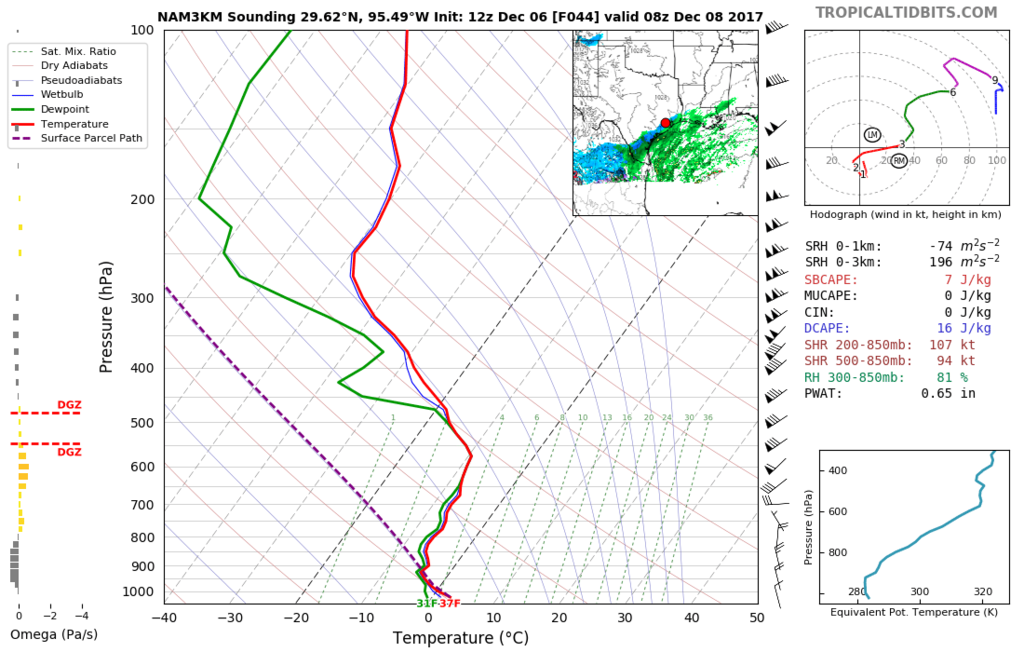
Thursday midday may be our best chance for flakes in SE Tx. With the rain, a thick cloud deck, low freezing heights in the atmosphere, currently it has the temp warming to 46 from 42. I find this tough to believe with freezing levels at the 900 MB level. It's a quick rise in temps to the surface. Lets hope the temps are wrong.

Getting more confident in a surprise when i look at the soundings.
0 likes   
Personal Forecast Disclaimer:
The posts in this forum are NOT official forecast and should not be used as such. They are just the opinion of the poster and may or may not be backed by sound meteorological data. They are NOT endorsed by any professional institution or storm2k.org. For official information, please refer to the NHC and NWS products.

User avatar
JDawg512
Category 5
Category 5
Posts: 1077
Age: 45
Joined: Mon Aug 26, 2013 8:56 pm
Location: Austin
Contact:

Re: Texas Winter 2017-2018

#686 Postby JDawg512 » Wed Dec 06, 2017 5:33 am

Rain is finally increasing in areal coverage. I'm satisfied for the time being. Will be a lovely day, looking forward to a nice strole in the park.
2 likes   
Resident Rain Miser

I am a weather hobbyist living 3.5 miles south of Downtown Austin and in no way or fashion should anything I say concerning forecasts be taken seriously. Please check your local NWS for accurate weather forecasting and conditions.

User avatar
Cpv17
Category 5
Category 5
Posts: 4979
Joined: Wed Dec 07, 2016 2:24 pm
Location: Wharton/El Campo, TX

Re: Texas Winter 2017-2018

#687 Postby Cpv17 » Wed Dec 06, 2017 6:02 am

06z GFS is now saying some light snow may mix in with rain over parts of SE TX early Friday morning. The trend is our friend! :cold:

Image

Also, the next front on the GFS keeps trending more west towards TX.

Image
3 likes   

weatherdude1108
Category 5
Category 5
Posts: 4228
Joined: Tue Dec 13, 2011 1:04 pm
Location: Northwest Austin/Cedar Park, TX

Re: Texas Winter 2017-2018

#688 Postby weatherdude1108 » Wed Dec 06, 2017 7:37 am

JDawg512 wrote:Rain is finally increasing in areal coverage. I'm satisfied for the time being. Will be a lovely day, looking forward to a nice strole in the park.


Great news! Looks like a nice rain shield in the southern parts of Austin, whereas it has let up here for the time being. My gauge shows an inch since yesterday. Been so dry, this is nice! Hope it keeps up. After tomorrow, no telling when next chance is. Snow would be icing on the cake (so to speak).;)
Last edited by weatherdude1108 on Wed Dec 06, 2017 3:59 pm, edited 1 time in total.
2 likes   
The preceding post is NOT an official forecast, and should not be used as such. It is only the opinion of the poster and may or may not be backed by sound meteorological data. It is NOT endorsed by any professional institution including storm2k.org. For Official Information please refer to the NHC and NWS products.

Yukon Cornelius
S2K Supporter
S2K Supporter
Posts: 1798
Age: 41
Joined: Thu Dec 20, 2012 9:23 pm
Location: Dean, TX/Westcliffe, CO

Re: Texas Winter 2017-2018

#689 Postby Yukon Cornelius » Wed Dec 06, 2017 7:41 am

The temp up here hasn’t changed but maybe a degree or two from yesterday morning through this morning. Constant 41-42. Strange
Last edited by Yukon Cornelius on Wed Dec 06, 2017 8:13 am, edited 1 time in total.
0 likes   
#neversummer

User avatar
Cerlin
Category 5
Category 5
Posts: 1182
Age: 23
Joined: Thu Dec 08, 2016 12:06 am
Location: Norman, OK

Re: Texas Winter 2017-2018

#690 Postby Cerlin » Wed Dec 06, 2017 7:52 am

Finally these models are looking good for the cold in TX!! Hopefully DFW can get some sort of winter event soon, it's been years since we've had some true snow.
0 likes   
Graduate Meteorology Student at the University of Oklahoma!
All opinions independent of employers and the university.

User avatar
wxman57
Moderator-Pro Met
Moderator-Pro Met
Posts: 22979
Age: 67
Joined: Sat Jun 21, 2003 8:06 pm
Location: Houston, TX (southwest)

Re: Texas Winter 2017-2018

#691 Postby wxman57 » Wed Dec 06, 2017 7:53 am

Cold and rainy day. The weather just doesn't get any better than this! If only it was 20-30 degrees colder... :jacket:
10 likes   

User avatar
ThunderSleetDreams
S2K Supporter
S2K Supporter
Posts: 1477
Age: 43
Joined: Tue Dec 20, 2011 4:42 pm
Location: S of Weimar, TX

Re: Texas Winter 2017-2018

#692 Postby ThunderSleetDreams » Wed Dec 06, 2017 8:25 am

wxman57 wrote:Cold and rainy day. The weather just doesn't get any better than this! If only it was 20-30 degrees colder... :jacket:


What did you do with wxman57?

Wooooo, winter is here!
1 likes   
#NeverSummer

I hibernate when it gets above 75 degrees!

User avatar
TeamPlayersBlue
Category 5
Category 5
Posts: 3445
Joined: Tue Feb 02, 2010 1:44 am
Location: Denver/Applewood, CO

Re: Texas Winter 2017-2018

#693 Postby TeamPlayersBlue » Wed Dec 06, 2017 9:11 am

Help me out here professional mets, with the cool 1+2, does that help really drive the trough down through Texas?
Over the last year i thought this was key really getting the trough to dip down hard into Texas. Last year when 1+2 warmed up drastically, it shut down any chance of heights getting low over Texas, this time, 1+2 is quite cool and this trough is digging down HARD over Texas. Dont see this often.
0 likes   
Personal Forecast Disclaimer:
The posts in this forum are NOT official forecast and should not be used as such. They are just the opinion of the poster and may or may not be backed by sound meteorological data. They are NOT endorsed by any professional institution or storm2k.org. For official information, please refer to the NHC and NWS products.

User avatar
CaptinCrunch
S2K Supporter
S2K Supporter
Posts: 8728
Age: 57
Joined: Mon Nov 03, 2003 4:33 pm
Location: Kennedale, TX (Tarrant Co.)

Re: Texas Winter 2017-2018

#694 Postby CaptinCrunch » Wed Dec 06, 2017 9:12 am

This thread flip-flops as much as the models do, Winter is coming, Winter canceled, it may get cold, looks like a torch all month.....LMAO, it's snowing somewhere in Texas, Winter is back!! :lol:

Yall are awesome!!
10 likes   

User avatar
srainhoutx
S2K Supporter
S2K Supporter
Posts: 6919
Age: 67
Joined: Sun Jan 14, 2007 11:34 am
Location: Haywood County, NC
Contact:

Re: Texas Winter 2017-2018

#695 Postby srainhoutx » Wed Dec 06, 2017 9:17 am

I noticed some changes overnight via the guidance suggesting the column is much more saturated than previously predicted into Thursday night/early Friday morning. I would not be surprised to hear a few reports of sleet pings coming in across our Region. Also, the temperature forecast is going to be very tricky with trends toward freezing temperatures along and N of I-10 early Saturday morning. The freeze longevity potential has increased somewhat with the potential of some locations dropping to near or below freezing for 4 to 6 hours. Gardeners be advised.
2 likes   
Carla/Alicia/Jerry(In The Eye)/Michelle/Charley/Ivan/Dennis/Katrina/Rita/Wilma/Ike/Harvey

Member: National Weather Association
Wx Infinity Forums
http://wxinfinity.com/index.php

Facebook.com/WeatherInfinity
Twitter @WeatherInfinity

User avatar
gboudx
S2K Supporter
S2K Supporter
Posts: 4080
Joined: Thu Sep 04, 2003 1:39 pm
Location: Rockwall, Tx but from Harvey, La

Re: Texas Winter 2017-2018

#696 Postby gboudx » Wed Dec 06, 2017 9:21 am

Update from jeff:

Winter Storm will move across TX today into Thursday

What the difference 24 hours makes…as strong cold air advection has resulted in temperatures falling into the lower to mid 40’s area wide compared to the lower 70’s at this time yesterday morning. Radar shows two bands of light to moderate rainfall over the region this morning with one favoring the coastal counties and the other generally NW of US 59. Strong jet stream aloft will continue to pump warm and moist air over the top of the cold surface dome allowing gradual lifting of the air mass and periods of rain. Biggest change overnight with respect to any winter type precipitation over the area has been the fact that the low level are more moist then forecasted and this will help to prevent evaporative cooling of the air column to support any mixed precipitation phases. A surge of drier air does begin to move into the region from the NNE early Thursday and this may offer a brief window Thursday morning where some sleet could mix with the rain, but think most areas will see a cold rain. Profiles south of HWY 105 are just too warm for anything other than liquid tonight into Thursday morning.

Rain will slowly end from N to S on Thursday into Thursday night, but the core of a cold upper level trough will move across SC TX Thursday night into Friday morning. Models continue to show the potential for the air column to cool across SC TX into the coastal bend region Thursday night/Friday morning suggesting a better potential for a mix of rain and sleet/snow. NAM is the most aggressive cooling the above freezing layer to nearly 500 ft above the ground which would likely allow snow/sleet to reach the ground, while much of the rest of the guidance has a much thicker (2000 ft) above freezing layer which would result in much of the sleet/snow changing back to rain or possibly a mix. Appears the Matagorda Bay region will lie on the northern edge of the precipitation shield with much drier air filtering in across much of SE TX by Thursday evening. Cannot rule out some sleet mixed with any lingering rainfall south of I-10 Thursday evening.

Other item of interest this morning is the potential for freezing temperatures Friday morning. Upper trough will be moving east of the area early Friday allowing clearing skies and with temperatures already in the mid to upper 30’s it will not take much to lower them toward freezing or below. Additionally, much drier air mass with dewpoints well into the 20’s will be arriving Thursday afternoon and evening which will help with the temperature fall. Think areas north of HWY 105 will fall below freezing for 3-4 hours Friday morning and may touch freezing as far south as I-10 away from the urban influences.
1 likes   

Yukon Cornelius
S2K Supporter
S2K Supporter
Posts: 1798
Age: 41
Joined: Thu Dec 20, 2012 9:23 pm
Location: Dean, TX/Westcliffe, CO

Re: Texas Winter 2017-2018

#697 Postby Yukon Cornelius » Wed Dec 06, 2017 9:39 am

CaptinCrunch wrote:This thread flip-flops as much as the models do, Winter is coming, Winter canceled, it may get cold, looks like a torch all month.....LMAO, it's snowing somewhere in Texas, Winter is back!! :lol:

Yall are awesome!!

Winter cant be back, it was cancelled last week! :D
3 likes   
#neversummer

User avatar
Tireman4
S2K Supporter
S2K Supporter
Posts: 5853
Age: 59
Joined: Fri Jun 30, 2006 1:08 pm
Location: Humble, Texas
Contact:

Re: Texas Winter 2017-2018

#698 Postby Tireman4 » Wed Dec 06, 2017 9:52 am

wxman57 wrote:Cold and rainy day. The weather just doesn't get any better than this! If only it was 20-30 degrees colder... :jacket:


Maybe this is switcheroo December. Everything he says is switched and he really means 80s and 90s. My head hurts right now....I bet to add to my misery, he will give conflicting forecasts ( like he did 3-4 years ago, the last time he was Mr Freeze/Heat Miser) on the same day...sigh..frickity frack..LOL
0 likes   

Ralph's Weather
S2K Supporter
S2K Supporter
Posts: 3269
Age: 38
Joined: Fri Dec 13, 2013 11:55 am
Location: Lindale, TX
Contact:

Re: Texas Winter 2017-2018

#699 Postby Ralph's Weather » Wed Dec 06, 2017 10:16 am

Per the GFS ensembles, there is no sign of warmth through Christmas, not that there are any signs of major cold either. Wish there was more of a rain signal though, but after mid month it does not look particularly dry either. December could well end up below normal, warm to start then generally near average and ending cold around Christmas. We have a solid -AO that seems to be set for the winter. The Polar Vortex lobe looks to stay centered over the Great Lakes/southern Hudson Bay just pinwheeling around for at least the remainder of the month. The NE Pacific ridge will reset to over Alaska after mid month.
0 likes   
Follow on Facebook at Ralph's Weather.

User avatar
TeamPlayersBlue
Category 5
Category 5
Posts: 3445
Joined: Tue Feb 02, 2010 1:44 am
Location: Denver/Applewood, CO

Re: Texas Winter 2017-2018

#700 Postby TeamPlayersBlue » Wed Dec 06, 2017 10:20 am

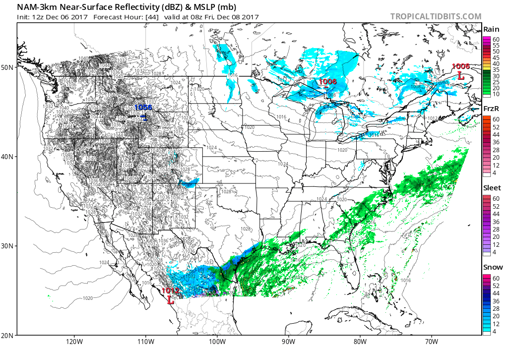
Latest NAM and the sounding for my neighborhood.

Image
Image
Last edited by TeamPlayersBlue on Wed Dec 06, 2017 10:21 am, edited 1 time in total.
3 likes   
Personal Forecast Disclaimer:
The posts in this forum are NOT official forecast and should not be used as such. They are just the opinion of the poster and may or may not be backed by sound meteorological data. They are NOT endorsed by any professional institution or storm2k.org. For official information, please refer to the NHC and NWS products.


Return to “Winter Weather”

Who is online

Users browsing this forum: No registered users and 13 guests