
WPAC: KAI-TAK - Post-Tropical
Moderator: S2k Moderators
-
mrbagyo

- Category 5

- Posts: 3998
- Age: 33
- Joined: Thu Apr 12, 2012 9:18 am
- Location: 14.13N 120.98E
- Contact:
Re: WPAC: KAI-TAK - Tropical Storm
^ I have this weird feeling that something really bad is now unfolding on that region especially in the province of Southern Leyte which is one of the most notoriously landslide prone area. Some of the deadliest landslides in Philippine history happened there (eg. Liloan -2003 & St. Bernard landslides-2006).
0 likes
The posts in this forum are NOT official forecast and should not be used as such. They are just the opinion of the poster and may or may not be backed by sound meteorological data. They are NOT endorsed by any professional institution or storm2k.org. For official information, please refer to RSMC, NHC and NWS products.
-
cycloneye

- Admin

- Posts: 149727
- Age: 69
- Joined: Thu Oct 10, 2002 10:54 am
- Location: San Juan, Puerto Rico
Re: WPAC: KAI-TAK - Tropical Storm
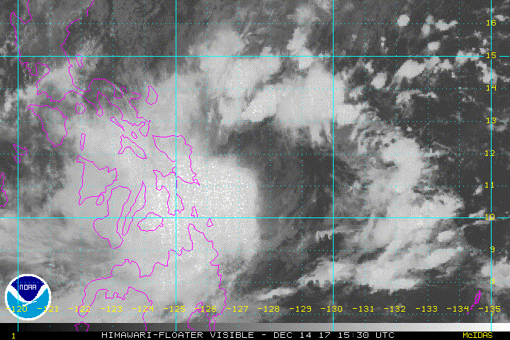
This storm may be a liittle bit stronger than what the agencies have if this ASCAT pass is right.

0 likes
Visit the Caribbean-Central America Weather Thread where you can find at first post web cams,radars
and observations from Caribbean basin members Click Here
and observations from Caribbean basin members Click Here
-
euro6208
Re: WPAC: KAI-TAK - Tropical Storm
WDPN31 PGTW 141500
MSGID/GENADMIN/JOINT TYPHOON WRNCEN PEARL HARBOR HI//
SUBJ/PROGNOSTIC REASONING FOR TROPICAL STORM 32W (KAI-TAK)
WARNING NR 04//
RMKS//
1. FOR METEOROLOGISTS.
2. 6 HOUR SUMMARY AND ANALYSIS.
TROPICAL STORM (TS) 32W (KAI-TAK), LOCATED APPROXIMATELY 433 NM
EAST-SOUTHEAST OF MANILA, PHILIPPINES, HAS TRACKED WEST-NORTHWESTWARD
AT 02 KNOTS OVER THE PAST SIX HOURS. ANIMATED ENHANCED INFRARED
SATELLITE IMAGERY DEPICTS A BROAD, EXPOSED LOW-LEVEL CIRCULATION
CENTER (LLCC) WITH DEEP CONVECTION DISPLACED OVER THE WESTERN SEMI-
CIRCLE DUE TO EASTERLY MODERATE TO STRONG (20 TO 30 KNOTS) VERTICAL
WIND SHEAR (VWS). HOWEVER, A 140958Z SSMIS 37GHZ IMAGE REVEALS
SLIGHTLY IMPROVED ORGANIZATION WITH DEEP CONVECTIVE BANDING OVER THE
NORTH QUADRANT WRAPPING INTO THE SOUTHWEST QUADRANT OF THE SYSTEM.
ANIMATED RADAR IMAGERY FROM PAGASA SHOWS HEAVY RAIN BANDS PERSISTING
OVER THE CENTRAL PHILIPPINES. THE INITIAL INTENSITY IS ASSESSED AT
35 KNOTS BASED ON DVORAK ESTIMATES RANGING FROM T2.0 TO T2.5 (30 TO
35 KNOTS) AND A 140958Z SATCON ESTIMATE OF 38 KNOTS. OVERALL,
THERE IS IMPROVED CONFIDENCE IN THE INITIAL POSITION BASED ON A
141144Z OSCAT IMAGE AND A 140918Z WINDSAT IMAGE, WHICH SUPPORT THE
62NM RELOCATION EAST-NORTHEAST OF THE PREVIOUS WARNING'S INITIAL
POSITION AT 14/06Z. TS 32W IS LOCATED WITHIN A COMPETING STEERING
ENVIRONMENT BETWEEN A SUBTROPICAL RIDGE (STR) TO THE NORTH AND
NORTHEAST, AND A NEAR-EQUATORIAL RIDGE (NER) TO THE SOUTH,
THEREFORE, MOTION IS SLOW AND PERHAPS QUASI-STATIONARY.
3. FORECAST REASONING.
A. NO CHANGE TO THE FORECAST PHILOSOPHY SINCE THE PREVIOUS
PROGNOSTIC REASONING MESSAGE.
B. IN THE NEAR TERM, THERE IS A LARGE DEGREE OF UNCERTAINTY IN
THE EXACT TRACK OF THE SYSTEM DUE TO THE COMPETING STEERING
INFLUENCES AND BROAD NATURE OF THE LLCC. DYNAMIC MODEL TRACKERS
INDICATE A LARGE SPREAD IN SOLUTIONS FROM A NORTH-NORTHEASTWARD TO
WEST-SOUTHWESTWARD TRACK THROUGH TAU 48. THE JTWC FORECAST FAVORS A
SLOW NORTHWESTWARD TO WESTWARD TRACK DUE TO THE POSITION OF THE STR
TO THE NORTHEAST AND NORTH. THE SYSTEM SHOULD INTENSIFY SLOWLY TO A
PEAK INTENSITY OF 40 KNOTS DUE TO THE PRESENCE OF WARM SST (28-29C),
HIGH OCEAN HEAT CONTENT VALUES AND STRONG UPPER-LEVEL DIFFLUENCE
OFFSET BY THE MODERATE TO STRONG VWS AND THE PROXIMITY TO LAND.
AFTER TAU 48, THE NER IS FORECAST TO WEAKEN WHICH WILL ALLOW
THE SYSTEM TO ACCELERATE WESTWARD OVER THE CENTRAL PHILIPPINES WHILE
WEAKENING DUE TO INCREASED LAND INTERACTION AND PERSISTENT VWS.
C. AFTER TAU 72, TS 32W IS FORECAST TO ACCELERATE WEST-
SOUTHWESTWARD TO SOUTHWESTWARD WHILE BEGINNING TO INTERACT WITH A
STRONG NORTHEASTERLY SURGE EVENT. SLIGHT RE-INTENSIFICATION IS
EXPECTED BUT THIS IS PRIMARILY DUE TO THE NORTHEAST SURGE FLOW.
DISSIPATION IS EXPECTED AFTER TAU 120 AS THE SYSTEM BECOMES EMBEDDED
WITHIN THE STRONG NORTHEAST FLOW. OVERALL, THERE IS LOW CONFIDENCE
IN THE JTWC FORECAST TRACK.//
NNNN
0 likes
-
1900hurricane

- Category 5
- Posts: 6063
- Age: 34
- Joined: Fri Feb 06, 2015 12:04 pm
- Location: Houston, TX
- Contact:
Re: WPAC: KAI-TAK - Tropical Storm
Both of the previous ASCAT passes from 12-13Z today had 50 kt wind vectors just to the south of the center. However, it now appears that Kai-tak may be decoupling, or at least on the verge of doing so.

0 likes
Contract Meteorologist. TAMU & MSST. Fiercely authentic, one of a kind. We are all given free will, so choose a life meant to be lived. We are the Masters of our own Stories.
Opinions expressed are mine alone.
Follow me on Twitter at @1900hurricane : Read blogs at https://1900hurricane.wordpress.com/
Opinions expressed are mine alone.
Follow me on Twitter at @1900hurricane : Read blogs at https://1900hurricane.wordpress.com/
-
NotSparta

- Professional-Met

- Posts: 1677
- Age: 24
- Joined: Fri Aug 18, 2017 8:24 am
- Location: Naples, FL
- Contact:
Re: WPAC: KAI-TAK - Tropical Storm

0 likes
This post was probably an opinion of mine, and in no way is official. Please refer to http://www.hurricanes.gov for official tropical analysis and advisories.
My website, with lots of tropical wx graphics, including satellite and recon: http://cyclonicwx.com
My website, with lots of tropical wx graphics, including satellite and recon: http://cyclonicwx.com
-
mrbagyo
- Category 5
- Posts: 3998
- Age: 33
- Joined: Thu Apr 12, 2012 9:18 am
- Location: 14.13N 120.98E
- Contact:
Re: WPAC: KAI-TAK - Tropical Storm
Kai-tak has taken off all its clothes. Circulation is now fully exposed.
0 likes
-
euro6208
Re: WPAC: KAI-TAK - Tropical Storm
Up to 45 knots.
32W KAI-TAK 171215 0000 11.7N 127.7E WPAC 45 989
32W KAI-TAK 171215 0000 11.7N 127.7E WPAC 45 989
0 likes
-
1900hurricane
- Category 5
- Posts: 6063
- Age: 34
- Joined: Fri Feb 06, 2015 12:04 pm
- Location: Houston, TX
- Contact:
Re: WPAC: KAI-TAK - Tropical Storm
ACE and PDI thus far:
Code: Select all
Put file here.
>>> http://hurricanes.ral.ucar.edu/realtime/plots/northwestpacific/2017/wp322017/bwp322017.dat
System:    KAI-TAK (32W)
Date & Time        Vmax        ACE         PDI      Class
                   (kt)   Inst      Sum          Inst         Sum
------------------------------------------------------------------------
12/13/2017 18Z:  25,    0.0000,   0.0000,    0.000000,   0.000000,    XX
12/14/2017  0Z:  30,    0.0000,   0.0000,    0.000000,   0.000000,    XX
12/14/2017  6Z:  30,    0.0000,   0.0000,    0.000000,   0.000000,    XX
12/14/2017 12Z:  35,    0.1225,   0.1225,    0.042875,   0.042875,    XX
12/14/2017 18Z:  40,    0.1600,   0.2825,    0.064000,   0.106875,    XX
12/15/2017  0Z:  45,    0.2025,   0.4850,    0.091125,   0.198000,    XX
0 likes
Contract Meteorologist. TAMU & MSST. Fiercely authentic, one of a kind. We are all given free will, so choose a life meant to be lived. We are the Masters of our own Stories.
Opinions expressed are mine alone.
Follow me on Twitter at @1900hurricane : Read blogs at https://1900hurricane.wordpress.com/
Opinions expressed are mine alone.
Follow me on Twitter at @1900hurricane : Read blogs at https://1900hurricane.wordpress.com/
-
euro6208
Re: WPAC: KAI-TAK - Tropical Storm

WDPN31 PGTW 150300
MSGID/GENADMIN/JOINT TYPHOON WRNCEN PEARL HARBOR HI//
SUBJ/PROGNOSTIC REASONING FOR TROPICAL STORM 32W (KAI-TAK)
WARNING NR 06//
RMKS//
1. FOR METEOROLOGISTS.
2. 6 HOUR SUMMARY AND ANALYSIS.
TROPICAL STORM 32W (KAI-TAK), LOCATED APPROXIMATELY 428 NM
EAST-SOUTHEAST OF MANILA, PHILIPPINES, HAS TRACKED NORTHWARD AT 01
KNOT OVER THE PAST SIX HOURS. ANIMATED MULTISPECTRAL SATELLITE
IMAGERY DEPICTS A FULLY EXPOSED LOW LEVEL CIRCULATION (LLCC) WITH
CONVECTION SHEARED TO THE WEST. THE INITIAL POSITION IS BASED ON A
150000Z HIMAWARI VISIBLE SATELLITE IMAGE WHICH SHOWS THE FULLY
EXPOSED LLCC AND CONVECTION DISPLACED TO THE WEST. THE INITIAL
INTENSITY ESTIMATE OF 45 KNOTS IS BASED ON A 142235Z SATCON ESTIMATE
OF 40 KNOTS WITH TWO OF THREE SATCON MEMBERS INDICATING 44 KNOT
WINDS. THIS IS HEDGED ABOVE DVORAK ESTIMATES OF T2.5 (35 KNOTS) FROM
PGTW AND T2.0 (30 KNOTS) FROM RJTD. UPPER LEVEL ANALYSIS SHOWS
UNFAVORABLE VERTICAL WIND SHEAR (25 TO 30 KNOTS) ALONG WITH STRONG
POLEWARD OUTFLOW AND MODERATE EQUATORWARD OUTFLOW. SEA SURFACE
TEMPERATURES REMAIN FAVORABLE (29 DEGREES CELSIUS). TS 32W IS BEING
STEERED BY SUBTROPICAL RIDGES (STR) TO THE NORTHEAST AND NORTHWEST.
3. FORECAST REASONING.
A. NO CHANGE TO THE FORECAST PHILOSOPHY SINCE THE PREVIOUS
PROGNOSTIC REASONING MESSAGE.
B. IN THE NEAR TERM, NUMERICAL MODEL GUIDANCE IS NOW IN SLIGHTLY
BETTER AGREEMENT, INDICATING A NORTHWESTWARD TRACK WITH ONLY ONE
CONSENSUS MEMBER INDICATING A NORTHEASTWARD TRACK. THE JTWC FORECAST
FAVORS A SLOW NORTHWESTWARD TRACK AND EVENTUALLY WESTWARD TRACK DUE
TO THE POSITION OF THE STRS WHICH ARE LOCATED TO THE NORTHEAST AND
NORTHWEST. THE SYSTEM WILL MAINTAIN A PEAK INTENSITY OF 45 KNOTS
THROUGH TAU 24 DUE TO FAVORABLE SSTS (29 DEGREES CELSIUS), HIGH OCEAN
HEAT CONTENT VALUES AND STRONG UPPER-LEVEL DIFFLUENCE. STRONG
VERTICAL WIND SHEAR AND THE PROXIMITY TO LAND WILL LIMIT ADDITIONAL
INTENSIFICATION. TS 32W WILL SLOWLY WEAKEN AND TRACK GENERALLY
WESTWARD AFTER TAU 24 WHILE STILL UNDER THE INFLUENCE OF THE STRS TO
THE NORTH.
C. AFTER TAU 72, TS 32W IS FORECAST TO ACCELERATE
WEST-SOUTHWESTWARD TO SOUTHWESTWARD AND WILL INTERACT WITH A STRONG
NORTHEASTERLY SURGE EVENT JUST BEFORE TAU 96. DISSIPATION IS EXPECTED
BEYOND TAU 120 AS THE SYSTEM BECOMES EMBEDDED WITHIN THE STRONG
NORTHEASTERLY FLOW. HOWEVER, SEVERAL NUMERICAL MODELS ARE NOW
INDICATING THAT TS 32W WILL ATTEMPT TO MAINTAIN AN ORGANIZED
CIRCULATION AS IT TRACKS THROUGH THE SOUTH CHINA SEA. OVERALL, THERE
IS LOW CONFIDENCE IN THE JTWC FORECAST TRACK.//
NNNN
0 likes

Re: WPAC: KAI-TAK - Tropical Storm
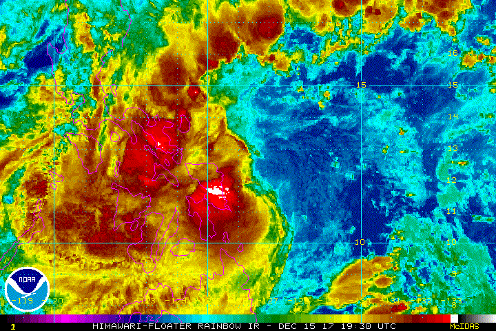
Extremely cold cloud tops. Kai-tak is clothing itself again.

0 likes
The above post is not official and should not be used as such. It is the opinion of the poster and may or may not be backed by sound meteorological data. It is not endorsed by any professional institution or storm2k.org. For official information, please refer to the NHC and NWS products.
Re: WPAC: KAI-TAK - Tropical Storm
Looks like a CCC pattern to me and cloud patterns suggest that Kai-Tak is still badly hit by shear. Looks like its intensity would plateau for the time being.
0 likes
Personal Forecast Disclaimer:
The posts in this forum are NOT official forecast and should not be used as such. They are just the opinion of the poster and may or may not be backed by sound meteorological data. They are NOT endorsed by any professional institution or storm2k.org. For official information, please refer to RSMC and NWS products.
The posts in this forum are NOT official forecast and should not be used as such. They are just the opinion of the poster and may or may not be backed by sound meteorological data. They are NOT endorsed by any professional institution or storm2k.org. For official information, please refer to RSMC and NWS products.
-
mrbagyo
- Category 5
- Posts: 3998
- Age: 33
- Joined: Thu Apr 12, 2012 9:18 am
- Location: 14.13N 120.98E
- Contact:
Re: WPAC: KAI-TAK - Tropical Storm
Heard from a local news program that Guiuan, Samar has already recorded 700 mm of rain for the past 24 hours alone - that's more than their typical monthly average of 400mm
0 likes
The posts in this forum are NOT official forecast and should not be used as such. They are just the opinion of the poster and may or may not be backed by sound meteorological data. They are NOT endorsed by any professional institution or storm2k.org. For official information, please refer to RSMC, NHC and NWS products.
-
1900hurricane
- Category 5
- Posts: 6063
- Age: 34
- Joined: Fri Feb 06, 2015 12:04 pm
- Location: Houston, TX
- Contact:
Re: WPAC: KAI-TAK - Tropical Storm
I think even calling it a CCC is a little generous since the center of a CCC system is at least under the convection. I'd just say Kai-tak is badly sheared.
0 likes
Contract Meteorologist. TAMU & MSST. Fiercely authentic, one of a kind. We are all given free will, so choose a life meant to be lived. We are the Masters of our own Stories.
Opinions expressed are mine alone.
Follow me on Twitter at @1900hurricane : Read blogs at https://1900hurricane.wordpress.com/
Opinions expressed are mine alone.
Follow me on Twitter at @1900hurricane : Read blogs at https://1900hurricane.wordpress.com/
-
1900hurricane
- Category 5
- Posts: 6063
- Age: 34
- Joined: Fri Feb 06, 2015 12:04 pm
- Location: Houston, TX
- Contact:
Re: WPAC: KAI-TAK - Tropical Storm
Talk about goofy short term movement.

0 likes
Contract Meteorologist. TAMU & MSST. Fiercely authentic, one of a kind. We are all given free will, so choose a life meant to be lived. We are the Masters of our own Stories.
Opinions expressed are mine alone.
Follow me on Twitter at @1900hurricane : Read blogs at https://1900hurricane.wordpress.com/
Opinions expressed are mine alone.
Follow me on Twitter at @1900hurricane : Read blogs at https://1900hurricane.wordpress.com/
-
dexterlabio
- Category 5
- Posts: 3518
- Joined: Sat Oct 24, 2009 11:50 pm
Re: WPAC: KAI-TAK - Tropical Storm
Perhaps the best "good" news for now is that there have been no reported major flashfloods or landslides in Samar and Leyte provinces. These areas have some of the worst geohazards caused by a storm.
0 likes
Personal Forecast Disclaimer:
The posts in this forum are NOT official forecast and should not be used as such. They are just the opinion of the poster and may or may not be backed by sound meteorological data. They are NOT endorsed by any professional institution or storm2k.org. For official information, please refer to the NHC and NWS products.
The posts in this forum are NOT official forecast and should not be used as such. They are just the opinion of the poster and may or may not be backed by sound meteorological data. They are NOT endorsed by any professional institution or storm2k.org. For official information, please refer to the NHC and NWS products.
Re: WPAC: KAI-TAK - Tropical Storm
dexterlabio wrote:Perhaps the best "good" news for now is that there have been no reported major flashfloods or landslides in Samar and Leyte provinces. These areas have some of the worst geohazards caused by a storm.
there has been major flooding. I've had some pics e-mailed to me. My fear is this could be like Harvey given how slow this is moving and how heavy the rains appear to be from satellite
0 likes
-
mrbagyo
- Category 5
- Posts: 3998
- Age: 33
- Joined: Thu Apr 12, 2012 9:18 am
- Location: 14.13N 120.98E
- Contact:
Re: WPAC: KAI-TAK - Tropical Storm
Tacloban is now in state of calamity, we don't know yet what happened to the remote areas.
0 likes
The posts in this forum are NOT official forecast and should not be used as such. They are just the opinion of the poster and may or may not be backed by sound meteorological data. They are NOT endorsed by any professional institution or storm2k.org. For official information, please refer to RSMC, NHC and NWS products.
-
xtyphooncyclonex

- Category 5
- Posts: 3900
- Age: 24
- Joined: Sat Dec 08, 2012 9:07 am
- Location: Cebu City
- Contact:
Re: WPAC: KAI-TAK - Tropical Storm
dexterlabio wrote:Perhaps the best "good" news for now is that there have been no reported major flashfloods or landslides in Samar and Leyte provinces. These areas have some of the worst geohazards caused by a storm.
Tacloban is under a state of calamity.
0 likes
REMINDER: My opinions that I, or any other NON Pro-Met in this forum, are unofficial. Please do not take my opinions as an official forecast and warning. I am NOT a meteorologist. Following my forecasts blindly may lead to false alarm, danger and risk if official forecasts from agencies are ignored.
-
mrbagyo
- Category 5
- Posts: 3998
- Age: 33
- Joined: Thu Apr 12, 2012 9:18 am
- Location: 14.13N 120.98E
- Contact:
Re: WPAC: KAI-TAK - Tropical Storm
Bulk of very intense convection is still covering the entire Samar Island. Wont be surprised now if some areas have already seen rainfall total well above 1,000 mm. This is a way much wetter storm than Thelma and Ketsana
1 likes
The posts in this forum are NOT official forecast and should not be used as such. They are just the opinion of the poster and may or may not be backed by sound meteorological data. They are NOT endorsed by any professional institution or storm2k.org. For official information, please refer to RSMC, NHC and NWS products.
Who is online
Users browsing this forum: No registered users and 100 guests