Texas Winter 2017-2018

Winter Weather Discussion

Moderator: S2k Moderators

Forum rules

The posts in this forum are NOT official forecast and should not be used as such. They are just the opinion of the poster and may or may not be backed by sound meteorological data. They are NOT endorsed by any professional institution or STORM2K.

Help Support Storm2K
Message
Author
User avatar
wxman57
Moderator-Pro Met
Moderator-Pro Met
Posts: 22990
Age: 67
Joined: Sat Jun 21, 2003 8:06 pm
Location: Houston, TX (southwest)

Re: Texas Winter 2017-2018

#2361 Postby wxman57 » Sun Dec 17, 2017 5:38 pm

missygirl810 wrote:
All of you must get one h*ll of a headache trying to figure all of those out!! LOL!!


That's particularly true when using them to predict a hurricane's track. We'll be looking at over 100 different possible tracks. In that case, averaging the ensemble members plus the operational runs often produces quite a good forecast track. With other weather, taking a look at the "ensemble mean" (average), can provide valuable info.
1 likes   

User avatar
missygirl810
Tropical Storm
Tropical Storm
Posts: 154
Joined: Fri Oct 27, 2017 3:07 pm
Location: Celeste TX Hunt County Fannin Co line

Re: Texas Winter 2017-2018

#2362 Postby missygirl810 » Sun Dec 17, 2017 5:41 pm

Ralph's Weather wrote:
wxman57 wrote:
Ralph's Weather wrote:

Yes, ensembles are typically more accurate especially at longer ranges (beyond 4 or 5 days).


I wouldn't say that ensembles are, individually, more than the operational runs. An ensemble is a number of extra runs of a model, like the GFS. The GFS has 20 ensemble members (runs). Each of the 20 ensemble members is run with slightly different initial conditions, to try to take into consideration the uncertainty in the initial atmospheric conditions. To save time, these 20 GFS ensemble members are run at a lower resolution than the operational run. As a whole, the ensemble members provide a range of uncertainty in the operational run. It IS true that averaging a number of ensemble members can often produce a better overall forecast than the operational run. But just because a few of the 20 GFS ensembles say snow doesn't make snow more likely. It's the average that counts.

By the way, the Canadian model also has 20 ensemble members. The ECMWF has 51 members, 50 run with slightly different initial conditions and 1 run with the same initial conditions as the operational run but run at the lower resolution of the other 50 members.
I wanted to make my post along these lines but my 2 year old was not patient enough for that. Thanks for elaborating.


Yeah, they don't huh lol. My youngest is 14 and still the same way now lol.
1 likes   

User avatar
missygirl810
Tropical Storm
Tropical Storm
Posts: 154
Joined: Fri Oct 27, 2017 3:07 pm
Location: Celeste TX Hunt County Fannin Co line

Re: Texas Winter 2017-2018

#2363 Postby missygirl810 » Sun Dec 17, 2017 5:43 pm

wxman57 wrote:
missygirl810 wrote:
All of you must get one h*ll of a headache trying to figure all of those out!! LOL!!


That's particularly true when using them to predict a hurricane's track. We'll be looking at over 100 different possible tracks. In that case, averaging the ensemble members plus the operational runs often produces quite a good forecast track. With other weather, taking a look at the "ensemble mean" (average), can provide valuable info.


That must be why we see the spaghetti models on TV.
0 likes   

Ralph's Weather
S2K Supporter
S2K Supporter
Posts: 3269
Age: 38
Joined: Fri Dec 13, 2013 11:55 am
Location: Lindale, TX
Contact:

Re: Texas Winter 2017-2018

#2364 Postby Ralph's Weather » Sun Dec 17, 2017 5:51 pm

18Z GFS has the ridge oriented oddly from the GoA to the Bering Sea which changes the trajectory of things downstream sending things further east than previous runs.
1 likes   
Follow on Facebook at Ralph's Weather.

User avatar
starsfan65
Category 2
Category 2
Posts: 704
Age: 47
Joined: Thu Dec 17, 2015 1:18 pm
Location: Garland,Tx

Re: Texas Winter 2017-2018

#2365 Postby starsfan65 » Sun Dec 17, 2017 5:55 pm

Ralph's Weather wrote:18Z GFS has the ridge oriented oddly from the GoA to the Bering Sea which changes the trajectory of things downstream sending things further east than previous runs.

What does that mean?
0 likes   

Ralph's Weather
S2K Supporter
S2K Supporter
Posts: 3269
Age: 38
Joined: Fri Dec 13, 2013 11:55 am
Location: Lindale, TX
Contact:

Re: Texas Winter 2017-2018

#2366 Postby Ralph's Weather » Sun Dec 17, 2017 6:02 pm

starsfan65 wrote:
Ralph's Weather wrote:18Z GFS has the ridge oriented oddly from the GoA to the Bering Sea which changes the trajectory of things downstream sending things further east than previous runs.

What does that mean?

No aignificant storms around here after Tuesday
0 likes   
Follow on Facebook at Ralph's Weather.

User avatar
cheezyWXguy
Category 5
Category 5
Posts: 6110
Joined: Mon Feb 13, 2006 12:29 am
Location: Dallas, TX

Re: Texas Winter 2017-2018

#2367 Postby cheezyWXguy » Sun Dec 17, 2017 6:02 pm

Ralph's Weather wrote:18Z GFS has the ridge oriented oddly from the GoA to the Bering Sea which changes the trajectory of things downstream sending things further east than previous runs.

While I agree, it is worth noting that the trough is generally deeper and less progressive this run, leading to Texas being colder after 12/24 than the previous run. Seems to me like a cautiously optimistic development, but still wouldn’t put much stock in it, as these models clearly have a lot more shifting to do
1 likes   

User avatar
starsfan65
Category 2
Category 2
Posts: 704
Age: 47
Joined: Thu Dec 17, 2015 1:18 pm
Location: Garland,Tx

Re: Texas Winter 2017-2018

#2368 Postby starsfan65 » Sun Dec 17, 2017 6:08 pm

cheezyWXguy wrote:
Ralph's Weather wrote:18Z GFS has the ridge oriented oddly from the GoA to the Bering Sea which changes the trajectory of things downstream sending things further east than previous runs.

While I agree, it is worth noting that the trough is generally deeper and less progressive this run, leading to Texas being colder after 12/24 than the previous run. Seems to me like a cautiously optimistic development, but still wouldn’t put much stock in it, as these models clearly have a lot more shifting to do
What about Thursday and Friday?
0 likes   

Brent
S2K Supporter
S2K Supporter
Posts: 38105
Age: 37
Joined: Sun May 16, 2004 10:30 pm
Location: Tulsa Oklahoma
Contact:

Re: Texas Winter 2017-2018

#2369 Postby Brent » Sun Dec 17, 2017 6:26 pm

Im losing interest in Friday tbh unless something drastic changes i think the focus is shifting more towards Christmas and beyond

The issue with that is were back to being out in fantasy land. Kind of frustrating
Last edited by Brent on Sun Dec 17, 2017 6:26 pm, edited 1 time in total.
0 likes   
#neversummer

User avatar
bubba hotep
S2K Supporter
S2K Supporter
Posts: 5837
Joined: Wed Dec 28, 2016 1:00 am
Location: Collin County Texas

Re: Texas Winter 2017-2018

#2370 Postby bubba hotep » Sun Dec 17, 2017 6:26 pm

18z GEFS is interesting, this is as good as it has looked in a while now. I wonder if we will see the 00z models trend towards a solution more favorable of winter wx?

Image
4 likes   
Winter time post are almost exclusively focused on the DFW area.

User avatar
starsfan65
Category 2
Category 2
Posts: 704
Age: 47
Joined: Thu Dec 17, 2015 1:18 pm
Location: Garland,Tx

Re: Texas Winter 2017-2018

#2371 Postby starsfan65 » Sun Dec 17, 2017 6:28 pm

Brent wrote:Im losing interest in Friday tbh unless something drastic changes i think the focus is shifting more towards Christmas and beyond

The issue with that is were back to being out in fantasy land. Kind of frustrating

Don't give up hope!!
2 likes   

User avatar
bubba hotep
S2K Supporter
S2K Supporter
Posts: 5837
Joined: Wed Dec 28, 2016 1:00 am
Location: Collin County Texas

Re: Texas Winter 2017-2018

#2372 Postby bubba hotep » Sun Dec 17, 2017 6:32 pm

Brent wrote:Im losing interest in Friday tbh unless something drastic changes i think the focus is shifting more towards Christmas and beyond

The issue with that is were back to being out in fantasy land. Kind of frustrating


Remember, the rain last night and the system coming up on Tuesday were basically missed by the models until just a few days out. The models were really struggling with how to handle this next system before locking in on a more compact and vigorous vort.
3 likes   
Winter time post are almost exclusively focused on the DFW area.

aggiecutter
Category 5
Category 5
Posts: 1753
Joined: Thu Oct 14, 2004 9:22 pm
Location: Texarkana

Re: Texas Winter 2017-2018

#2373 Postby aggiecutter » Sun Dec 17, 2017 6:34 pm

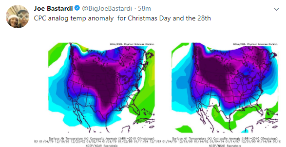
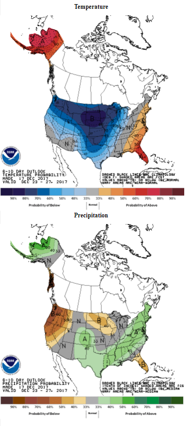
Analogs and pattern is all that matters. Looking at weather models is like asking a drunk monkey what the weather is going to be next week.


Image
0 likes   

Brent
S2K Supporter
S2K Supporter
Posts: 38105
Age: 37
Joined: Sun May 16, 2004 10:30 pm
Location: Tulsa Oklahoma
Contact:

Re: Texas Winter 2017-2018

#2374 Postby Brent » Sun Dec 17, 2017 6:40 pm

bubba hotep wrote:18z GEFS is interesting, this is as good as it has looked in a while now. I wonder if we will see the 00z models trend towards a solution more favorable of winter wx?

http://models.weatherbell.com/gefs/2017 ... _tx_40.png


Looks like quite a few have the Christmas storm or the day after
Last edited by Brent on Sun Dec 17, 2017 6:42 pm, edited 1 time in total.
0 likes   
#neversummer

User avatar
JDawg512
Category 5
Category 5
Posts: 1078
Age: 45
Joined: Mon Aug 26, 2013 8:56 pm
Location: Austin
Contact:

Re: Texas Winter 2017-2018

#2375 Postby JDawg512 » Sun Dec 17, 2017 6:42 pm

bubba hotep wrote:
Brent wrote:Im losing interest in Friday tbh unless something drastic changes i think the focus is shifting more towards Christmas and beyond

The issue with that is were back to being out in fantasy land. Kind of frustrating


Remember, the rain last night and the system coming up on Tuesday were basically missed by the models until just a few days out. The models were really struggling with how to handle this next system before locking in on a more compact and vigorous vort.


Agreed^^^
0 likes   
Resident Rain Miser

I am a weather hobbyist living 3.5 miles south of Downtown Austin and in no way or fashion should anything I say concerning forecasts be taken seriously. Please check your local NWS for accurate weather forecasting and conditions.

aggiecutter
Category 5
Category 5
Posts: 1753
Joined: Thu Oct 14, 2004 9:22 pm
Location: Texarkana

Re: Texas Winter 2017-2018

#2376 Postby aggiecutter » Sun Dec 17, 2017 6:45 pm

Image


Image
1 likes   

Ralph's Weather
S2K Supporter
S2K Supporter
Posts: 3269
Age: 38
Joined: Fri Dec 13, 2013 11:55 am
Location: Lindale, TX
Contact:

Re: Texas Winter 2017-2018

#2377 Postby Ralph's Weather » Sun Dec 17, 2017 6:48 pm

The models seem to be struggling with the extreme -EPO. Last week models were all about a major SW trough and thus weekend it is all about the huge surface high on the Plains. Something big is happening they just have not figured out what. I'll go with a combo of the ideas.
0 likes   
Follow on Facebook at Ralph's Weather.

User avatar
bubba hotep
S2K Supporter
S2K Supporter
Posts: 5837
Joined: Wed Dec 28, 2016 1:00 am
Location: Collin County Texas

Re: Texas Winter 2017-2018

#2378 Postby bubba hotep » Sun Dec 17, 2017 7:08 pm

Brent wrote:
bubba hotep wrote:18z GEFS is interesting, this is as good as it has looked in a while now. I wonder if we will see the 00z models trend towards a solution more favorable of winter wx?


Looks like quite a few have the Christmas storm or the day after


12z Euro EPS had 14 members with winter wx on Christmas Eve or Day at DFW. So there are still signs of a Christmas system out there in the ensembles.
3 likes   
Winter time post are almost exclusively focused on the DFW area.

User avatar
Quixotic
Category 2
Category 2
Posts: 729
Joined: Tue Feb 14, 2017 12:27 am
Location: Frisco

Re: Texas Winter 2017-2018

#2379 Postby Quixotic » Sun Dec 17, 2017 7:35 pm

FWD AFD referred to the initial surge of arctic air as being extremely shallow. It was giving the models fits in their opinion. They seemed to favor the deeper colder air arriving after Christmas.

The models seem to do a decent job on these shallow air masses as we get closer. It’s going to be a wild ride.
0 likes   

User avatar
iorange55
Category 5
Category 5
Posts: 2388
Joined: Thu Nov 13, 2008 9:47 pm
Location: Big D

Re: Texas Winter 2017-2018

#2380 Postby iorange55 » Sun Dec 17, 2017 7:36 pm

Yeah, I think we see a shift in the models tonight. I’m betting on the Christmas storm right now.
3 likes   


Return to “Winter Weather”

Who is online

Users browsing this forum: No registered users and 8 guests