Texas Winter 2017-2018
Moderator: S2k Moderators
Forum rules
 The posts in this forum are NOT official forecast and should not be used as such. They are just the opinion of the poster and may or may not be backed by sound meteorological data. They are NOT endorsed by any professional institution or STORM2K.

The posts in this forum are NOT official forecast and should not be used as such. They are just the opinion of the poster and may or may not be backed by sound meteorological data. They are NOT endorsed by any professional institution or STORM2K.
-
Ralph's Weather
- S2K Supporter

- Posts: 3371
- Age: 38
- Joined: Fri Dec 13, 2013 11:55 am
- Location: Lindale, TX
- Contact:
Re: Texas Winter 2017-2018
Freezing line almost to I35. Also almost down to 380 north of the Metroplex. All of DFW and almost down to I20 in NE TX are in the 30s.
2 likes
Follow on Facebook at Ralph's Weather.
-
bubba hotep

- S2K Supporter
- Posts: 6008
- Joined: Wed Dec 28, 2016 1:00 am
- Location: Collin County Texas
Re: Texas Winter 2017-2018
Ralph's Weather wrote:Freezing line almost to I35. Also almost down to 380 north of the Metroplex. All of DFW and almost down to I20 in NE TX are in the 30s.
36 IMBY, 35 up the road at the McKinney airport.
2 likes
Winter time post are almost exclusively focused on the DFW area.
Re: Texas Winter 2017-2018
Ralph's Weather wrote:Freezing line almost to I35. Also almost down to 380 north of the Metroplex. All of DFW and almost down to I20 in NE TX are in the 30s.
From what I can remember, it is colder right now than what the models were showing for around this time
2 likes
-
Texas Snowman

- Storm2k Moderator

- Posts: 6197
- Joined: Fri Jan 25, 2008 11:29 am
- Location: Denison, Texas
Re: Texas Winter 2017-2018
31 in Denison
1 likes
The above post and any post by Texas Snowman is NOT an official forecast and should not be used as such. It is just the opinion of the poster and may or may not be backed by sound meteorological data. It is NOT endorsed by any professional institution including storm2k.org. For official information, please refer to NWS products.
-
lrak

- S2K Supporter
- Posts: 1770
- Age: 59
- Joined: Thu Jun 21, 2007 2:48 pm
- Location: Corpus Christi, TX
Re: Texas Winter 2017-2018
Rgv20 wrote:South Texas Storms wrote:18z NAM shows sleet in Del Rio and San Antonio on Monday.
Can we expand that to Deep South Texas??
Maybe


1 likes
AKA karl
Also
Personal Forecast Disclaimer:
My posts on this forum are NOT official forecast and should not be used as such. My posts are my basic observations and are definitely not backed by any "well some" meteorological knowledge. For official information, please refer to the NHC and NWS products.
Also
Personal Forecast Disclaimer:
My posts on this forum are NOT official forecast and should not be used as such. My posts are my basic observations and are definitely not backed by any "well some" meteorological knowledge. For official information, please refer to the NHC and NWS products.
-
BrokenGlassRepublicn
- Category 1

- Posts: 483
- Joined: Sun Nov 20, 2011 8:07 pm
- Location: Richardson, Texas
Re: Texas Winter 2017-2018
Just made the drive from Dublin/Stephenville back to DFW. Drizzle was pretty heavy and my car thermometer read 32 through Weatherford, then kicked up to 35-36 in Ft Worth proper. Didn’t experience any ice...probably needed another degree or two. Stopped at Joe T’s to celebrate the warmer weather.
1 likes
-
lrak
- S2K Supporter
- Posts: 1770
- Age: 59
- Joined: Thu Jun 21, 2007 2:48 pm
- Location: Corpus Christi, TX
Re: Texas Winter 2017-2018
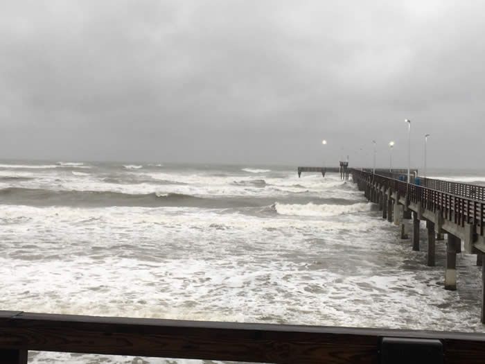
Humidity here has been close to 100% for almost a week. Maybe just maybe  that would be two event in one winter. I can't think of a colder pattern than this in awhile.
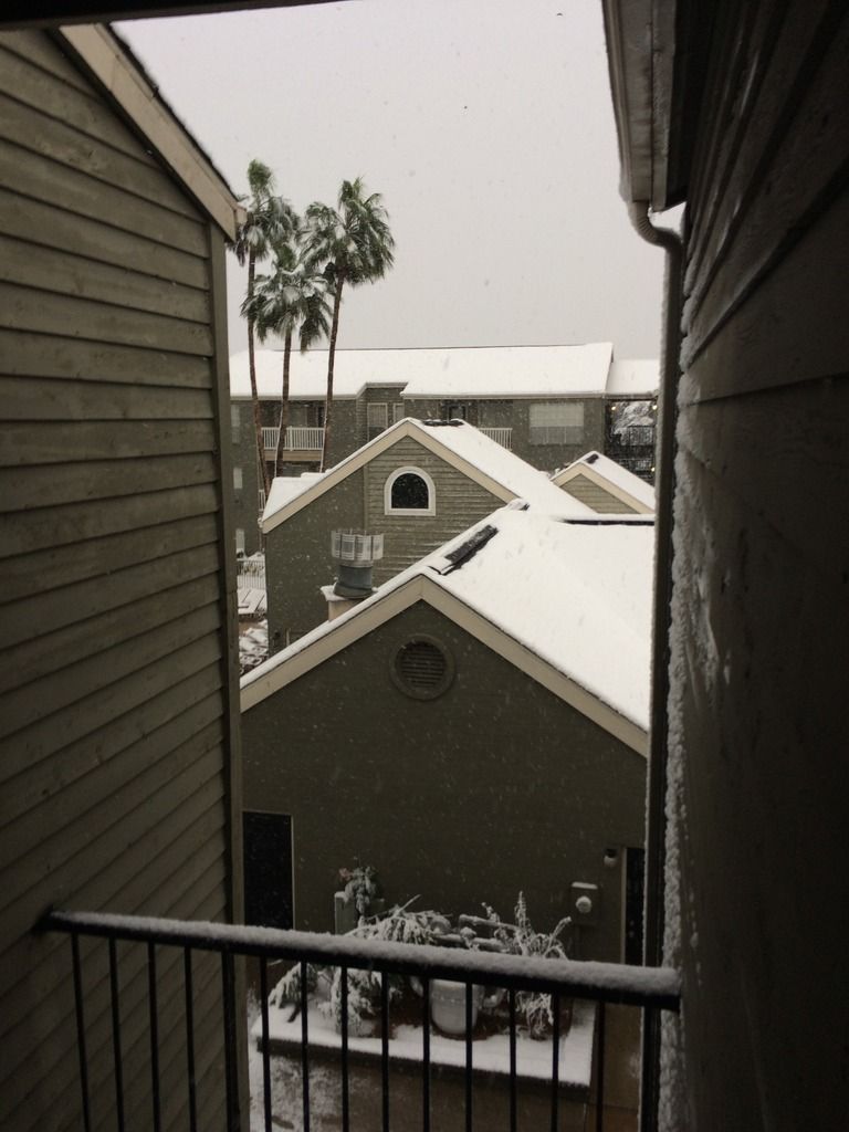
I forgot to upload the coastal snow pictures. be back. oops forgot the snow didn't actually happen during winter...lol
12-08-17 kinda late
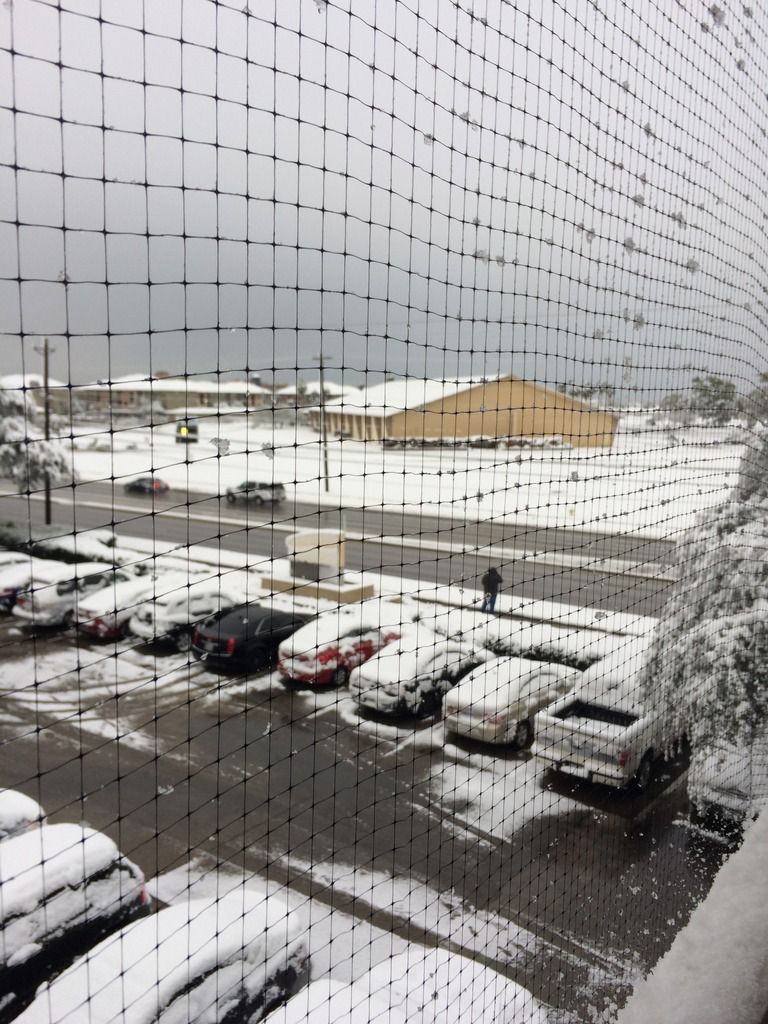
 too cold
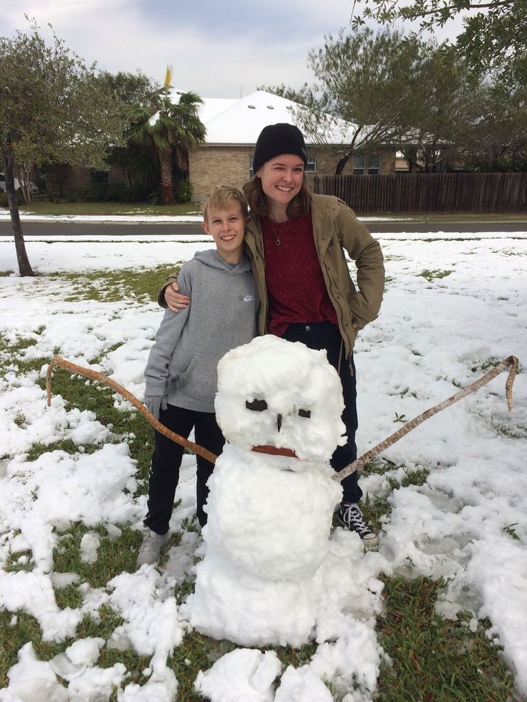
have to show off my great kids
I forgot to upload the coastal snow pictures. be back. oops forgot the snow didn't actually happen during winter...lol
12-08-17 kinda late
 too cold

have to show off my great kids

7 likes
AKA karl
Also
Personal Forecast Disclaimer:
My posts on this forum are NOT official forecast and should not be used as such. My posts are my basic observations and are definitely not backed by any "well some" meteorological knowledge. For official information, please refer to the NHC and NWS products.
Also
Personal Forecast Disclaimer:
My posts on this forum are NOT official forecast and should not be used as such. My posts are my basic observations and are definitely not backed by any "well some" meteorological knowledge. For official information, please refer to the NHC and NWS products.
-
Brent
- S2K Supporter
- Posts: 38705
- Age: 37
- Joined: Sun May 16, 2004 10:30 pm
- Location: Tulsa Oklahoma
- Contact:
Re: Texas Winter 2017-2018
NAM sure has a lot of precip around in the morning and definitely some snow
5 likes
#neversummer
-
longhornweather
- Tropical Depression

- Posts: 61
- Joined: Sat Feb 01, 2014 5:13 pm
- Location: Georgetown, TX
Re: Texas Winter 2017-2018
This place has become rather quiet this evening.
3 likes
This post is NOT AN OFFICIAL FORECAST and should not be used as such. It is just the opinion of the poster and may or may not be backed by sound meteorological data. It is NOT endorsed by any professional institution including storm2k.org. For Official Information please refer to the NHC and NWS products.
Re: Texas Winter 2017-2018
Ok, it is cold, getting colder and will be cold for a few days. I love it and it is luv-lee......but no snow. Orangeblood and others have pointed out some potential in the Jan 10th and beyond period. The teens and twenties are awesome but upper twenties and heavy snow are better. Damn I want to see one snowstorm.
2 likes
Re: Texas Winter 2017-2018
Brent wrote:NAM sure has a lot of precip around in the morning and definitely some snow
Thank you! I was just trying to look at the NAM but i couldnt find how to see the precip type... It did look like kind of a lot of precip from what i could see though.. Hopefully this actually means something good for us lol
1 likes
-
Brent
- S2K Supporter
- Posts: 38705
- Age: 37
- Joined: Sun May 16, 2004 10:30 pm
- Location: Tulsa Oklahoma
- Contact:
Re: Texas Winter 2017-2018
JayDT wrote:Brent wrote:NAM sure has a lot of precip around in the morning and definitely some snow
Thank you! I was just trying to look at the NAM but i couldnt find how to see the precip type... It did look like kind of a lot of precip from what i could see though.. Hopefully this actually means something good for us lol
Just hit the frozen option on the sidebar on the 12km
But there is right now a warm nose on the sounding so we'll have to see if that goes away for snow
1 likes
#neversummer
-
Rgv20

- S2K Supporter
- Posts: 2466
- Age: 39
- Joined: Wed Jan 05, 2011 5:42 pm
- Location: Edinburg/McAllen Tx
Re: Texas Winter 2017-2018
0zNAM coming in a bit wetter and Colder for South Texas.....Sleet so close to the RGV! 

1 likes
The following post is NOT an official forecast and should not be used as such. It is just the opinion of the poster and may or may not be backed by sound meteorological data. It is NOT endorsed by any professional institution including storm2k.org For Official Information please refer to the NHC and NWS products.
-
bubba hotep
- S2K Supporter
- Posts: 6008
- Joined: Wed Dec 28, 2016 1:00 am
- Location: Collin County Texas
Re: Texas Winter 2017-2018
Down to 33 IMBY, just waiting on some freezing drizzle...
3 likes
Winter time post are almost exclusively focused on the DFW area.
-
bubba hotep
- S2K Supporter
- Posts: 6008
- Joined: Wed Dec 28, 2016 1:00 am
- Location: Collin County Texas
Re: Texas Winter 2017-2018
Rgv20 wrote:0zNAM coming in a bit wetter and Colder for South Texas.....Sleet so close to the RGV!
http://i65.tinypic.com/30suj54.png
The SREF QPF mean is about 0.25" for the areas under that band.
0 likes
Winter time post are almost exclusively focused on the DFW area.
-
Rgv20
- S2K Supporter
- Posts: 2466
- Age: 39
- Joined: Wed Jan 05, 2011 5:42 pm
- Location: Edinburg/McAllen Tx
Re: Texas Winter 2017-2018
0 likes
The following post is NOT an official forecast and should not be used as such. It is just the opinion of the poster and may or may not be backed by sound meteorological data. It is NOT endorsed by any professional institution including storm2k.org For Official Information please refer to the NHC and NWS products.

Re: Texas Winter 2017-2018
Hello and Happy New Year to all.
I’m in Fort Worth and very small snow (or something) is falling here!
Sent from my iPhone using Tapatalk
I’m in Fort Worth and very small snow (or something) is falling here!
Sent from my iPhone using Tapatalk
4 likes
-
gboudx

- S2K Supporter
- Posts: 4090
- Joined: Thu Sep 04, 2003 1:39 pm
- Location: Rockwall, Tx but from Harvey, La
Re: Texas Winter 2017-2018
jstroud wrote:Hello and Happy New Year to all.
I’m in Fort Worth and very small snow (or something) is falling here!
Sent from my iPhone using Tapatalk
Could be graupel or snow grains.
1 likes
-
Rgv20
- S2K Supporter
- Posts: 2466
- Age: 39
- Joined: Wed Jan 05, 2011 5:42 pm
- Location: Edinburg/McAllen Tx
Re: Texas Winter 2017-2018
Special Weather Statement
National Weather Service Brownsville TX
851 PM CST Sat Dec 30 2017
TXZ248>257-311200-
Zapata-Jim Hogg-Brooks-Kenedy-Starr-Hidalgo-Inland Willacy-
Inland Cameron-Coastal Willacy-Coastal Cameron-
Including the cities of Zapata, Hebbronville, Falfurrias, Sarita,
Rio Grande City, Roma, McAllen, Edinburg, Pharr, Mission,
Weslaco, Raymondville, Brownsville, Harlingen, Port Mansfield,
Port Isabel, South Padre Island, Laguna Heights, and Laguna Vista
851 PM CST Sat Dec 30 2017
...Very cold weather expected for the start of 2018...
A potent Arctic air mass is forecast to move through Deep South
Texas and the Rio Grande Valley Sunday afternoon with temperatures
falling steadily through Tuesday morning. The surge of very cold
air arrives in two waves first Sunday early afternoon as a winds
turn northeast and temperatures begin to fall. A more substantial
surge is expected New Year`s Eve when stronger north winds arrive
and colder temperatures become more noticeable. Expect temperatures
to tumble into the upper 40s and low 50s, possibly colder, by
midnight New Year`s Eve with temperatures continuing to drop into
the 30s through Monday morning and likely to remain in the 30s all
day Monday. Strong Arctic high pressure continues to build into
the region through Wednesday night keeping temperatures well below
normal. Freezing temperatures are looking more likely for all
areas Tuesday morning and a freeze warning is anticipated to be
issued as early as Sunday afternoon. Highs on Tuesday will once
again struggle to rebound back into 40s with another good
potential for freezing temperatures Tuesday night and Wednesday
morning.
The combination of the very cold temperatures and the persistent
northerly surface winds will produce DANGEROUSLY low wind chill
values in the upper 20s to low 30s tomorrow night and the 20s
all day Monday and persisting well into Tuesday.
An upper level disturbance moves across Northern Mexico late New
Years Eve through Monday with light rain and drizzle is expected
to develop. Rain amounts are expected to be light and the
disturbance is expected to weaken considerably by Tuesday when
some temperatures approach freezing. There remains some potential
for light sleet over the Northern and Western Ranchlands Monday
morning and into the afternoon with little to no accumulation. An
a very low chance of a few ice pellets Monday night into Tuesday
morning for Mid and Lower Rio Grande Valley if there sufficient
moisture still left by the weakening disturbance. In any case,
residents should be prepared for very cold temperatures and the
low chance of some sleet.
Residents of Deep South Texas should make preparations for this
cold snap and remember the four P`s...Protection of Pipes,
Plants, and Pets. Stay tuned to the latest forecasts and
statements from the National Weather Service on this developing
winter weather situation.
$$
0 likes
The following post is NOT an official forecast and should not be used as such. It is just the opinion of the poster and may or may not be backed by sound meteorological data. It is NOT endorsed by any professional institution including storm2k.org For Official Information please refer to the NHC and NWS products.
-
bubba hotep
- S2K Supporter
- Posts: 6008
- Joined: Wed Dec 28, 2016 1:00 am
- Location: Collin County Texas
Re: Texas Winter 2017-2018
gboudx wrote:jstroud wrote:Hello and Happy New Year to all.
I’m in Fort Worth and very small snow (or something) is falling here!
Sent from my iPhone using Tapatalk
Could be graupel or snow grains.
Based on the 00z FWD sounding, that is just about all it could be. All the moisture is confined to the lowest levels and there is still a very warm and dry layer above.
0 likes
Winter time post are almost exclusively focused on the DFW area.
Who is online
Users browsing this forum: bubba hotep, Stratton23, TomballEd and 87 guests