99W INVEST 171228 1200 1.9N 145.0E WPAC 15 1006
Is this from the remnant of 98W or just an entirely new system?. Ive lost track of it.
WPAC: BOLAVEN - Post-Tropical
Moderator: S2k Moderators
-
mrbagyo

- Category 5

- Posts: 3963
- Age: 33
- Joined: Thu Apr 12, 2012 9:18 am
- Location: 14.13N 120.98E
- Contact:
WPAC: BOLAVEN - Post-Tropical
0 likes
The posts in this forum are NOT official forecast and should not be used as such. They are just the opinion of the poster and may or may not be backed by sound meteorological data. They are NOT endorsed by any professional institution or storm2k.org. For official information, please refer to RSMC, NHC and NWS products.
-
doomhaMwx

- Category 5
- Posts: 2487
- Age: 27
- Joined: Tue Apr 18, 2017 4:01 am
- Location: Baguio/Benguet, Philippines
- Contact:
Re: WPAC: INVEST 99W
Hmmm, it's pretty far from where 98W was last noted. NRL's last coordinates for 98W were 2.8N 160.3 at Dec 26th 18Z. This one cropped up near 145E, well to the south of Guam.
Anyway, this is the system shown by models for some time now that may affect the Philippines' Visayas and/or Mindanao region, on or around New Year's day.
Anyway, this is the system shown by models for some time now that may affect the Philippines' Visayas and/or Mindanao region, on or around New Year's day.
0 likes
-
euro6208
Re: WPAC: INVEST 99W
225
FXPQ60 PGUM 282000
AFDPQ
Area Forecast Discussion
National Weather Service Tiyan GU
600 AM ChST Fri Dec 29 2017
.Marianas Synopsis...
Satellite shows a large area of disturbed weather south of the
Marianas, with lightning strikes indicated to within 100 miles
southeast through southwest of Guam at times. But over the Marianas,
only isolated showers are seen under mostly cloudy skies. Seas range
from 7 to 8 feet at the buoys, with moderate to fresh trade winds.
&&
.Discussion...
Models are unanimous in keeping significant rainfall south of the
Guam waters today and tonight as the disturbance moves quickly west.
The GFS, ECMWF and NAVGEM models all show strong mid-level drying
over the weekend, limiting rain potential to no more than isolated
showers. But upper level moisture should persist through Sunday,
keeping skies mostly cloudy.
&&
.Marine...
Seas have come up again above 7 feet at Ipan, and latest WW3 guidance
keeps 7 ft east swell through tonight. Thus, have a high rip risk
today and tonight for east facing shores. The rip risk will fall back
to moderate for the weekend as combined seas diminish.
&&
.Eastern Micronesia and Chuuk...
A trade-wind convergent boundary can be seen in both ASCAT and IR
satellite imagery from just south of Chuuk, eastward across Kosrae to
south of Majuro then northeastward to beyond the Date Line. A few
thunderstorms are still possible near Chuuk today otherwise, drier
trades already over Pohnpei and Majuro will spread westward over
Chuuk later this evening. Since Kosrae is expected to remain close
to the boundary, periodic showers and thunderstorms will continue
thru Saturday night. The eastern portion of the convergent boundary
is going to approach the Marshall Islands this evening. Therefore,
anticipate wet weather to return to Majuro late tonight. This same
pattern will also prolong wetness near Kosrae into next week, and
arrive at Pohnpei and Chuuk early next week. Toward midweek next
week, drier northeasterly trades should once again return to the
region from east to west.
Residual trade-wind swell and wind waves will keep hazardous surf on
Kosrae thru this morning. By later this afternoon, swell and wind
waves should subside enough so that surf will fall below advisory
levels. Long-period NW swell generated by fresh to strong winds
behind a cold front/shear line near 25N will move toward Micronesia
on Saturday. This swell will peak across Chuuk, Pohnpei, Kosrae
States and the Marshall Islands Saturday night and Sunday. There is
the potential for hazardous surf along west and north facing shores.
&&
.Western Micronesia for Yap and Koror...
Latest ASCAT and IR satellite imagery suggest a broad but weak
circulation centered southeast of Yap near 3N144E. A surface trough
extends northward from this circulation to just south of Guam. At
the upper levels, a high is seen between Guam and Chuuk near 10N147E
and is providing divergent flow over far western Micronesia. Stronger
trade-wind convergence near the northern portion of the trough has
been coupling with divergent flow aloft to trigger widespread deep
convection across Yap State. This regime will continue thru Saturday
and may produce locally heavy downpours near Yap itself. With weaker
surface winds across Palau, mainly widely scattered showers are
expected thru tonight. Once stronger converging southeasterly winds
east of the trough axis have moved into Palau on Saturday, shower
coverage should increase to scattered. By Sunday evening, the trough
and circulation should push west of Palau. Lingering showers are
still probable on Monday, but drier trades should usher in fair
conditions by Tuesday.
North swell created by fresh winds associated with a shear line will
cause higher surf across Palau and western Yap State thru Saturday.
The chance of rip currents will increase but surf is not expected to
reach hazardous levels.
&&
.GUM WATCHES/WARNINGS/ADVISORIES...
GU...High Rip Current Risk through late tonight for GUZ001>004.
Marianas Waters...None.
&&
$$
Middlebrooke/Chan
0 likes


-
xtyphooncyclonex

- Category 5
- Posts: 3891
- Age: 24
- Joined: Sat Dec 08, 2012 9:07 am
- Location: Cebu City
- Contact:
Re: WPAC: INVEST 99W
GFS has become bullish again.... and it isn't even in the long range. For now I doubt it could be this strong, but it could be a sign of relaxing wind shear and increasingly favorable conditions. There's a chance this could be 90W instead of 99W

0 likes
REMINDER: My opinions that I, or any other NON Pro-Met in this forum, are unofficial. Please do not take my opinions as an official forecast and warning. I am NOT a meteorologist. Following my forecasts blindly may lead to false alarm, danger and risk if official forecasts from agencies are ignored.
-
Digital-TC-Chaser
Re: WPAC: INVEST 99W
WWJP25 RJTD 300000
WARNING AND SUMMARY 300000.
WARNING VALID 310000.
LOW PRESSURE AREA 1008 HPA NEAR 08N 138E WEST SLOWLY.
JAPAN METEOROLOGICAL AGENCY
http://gwydir.demon.co.uk/advisories/WW ... 300000.htm


WARNING AND SUMMARY 300000.
WARNING VALID 310000.
LOW PRESSURE AREA 1008 HPA NEAR 08N 138E WEST SLOWLY.
JAPAN METEOROLOGICAL AGENCY
http://gwydir.demon.co.uk/advisories/WW ... 300000.htm
0 likes


-
euro6208
Re: WPAC: INVEST 99W
xtyphooncyclonex wrote:GFS has become bullish again.... and it isn't even in the long range. For now I doubt it could be this strong, but it could be a sign of relaxing wind shear and increasingly favorable conditions. There's a chance this could be 90W instead of 99W
0 likes
-
Digital-TC-Chaser
Re: WPAC:JMA Tropical Depression
WWJP25 RJTD 300600
WARNING AND SUMMARY 300600.
WARNING VALID 310600.
WARNING IS UPDATED EVERY 6 HOURS.
SUMMARY.
TROPICAL DEPRESSION 1004 HPA AT 09N 136E WEST SLOWLY.
JAPAN METEOROLOGICAL AGENCY.=
http://gwydir.demon.co.uk/advisories/WW ... 300600.htm
http://www.jma.go.jp/jp/g3/images/48h/pdf/fsas48.pdf
WARNING AND SUMMARY 300600.
WARNING VALID 310600.
WARNING IS UPDATED EVERY 6 HOURS.
SUMMARY.
TROPICAL DEPRESSION 1004 HPA AT 09N 136E WEST SLOWLY.
JAPAN METEOROLOGICAL AGENCY.=
http://gwydir.demon.co.uk/advisories/WW ... 300600.htm
http://www.jma.go.jp/jp/g3/images/48h/pdf/fsas48.pdf
0 likes
-
xtyphooncyclonex
- Category 5
- Posts: 3891
- Age: 24
- Joined: Sat Dec 08, 2012 9:07 am
- Location: Cebu City
- Contact:
Re: WPAC: INVEST 99W
euro6208 wrote:xtyphooncyclonex wrote:GFS has become bullish again.... and it isn't even in the long range. For now I doubt it could be this strong, but it could be a sign of relaxing wind shear and increasingly favorable conditions. There's a chance this could be 90W instead of 99W
Hasn't GFS been like this for the longest time? By this time, we would be tracking a powerful typhoon. Then suddenly drops it and brings it back. GFS sucks. Had to say it.
Uhm, that's not necessarily what I meant. The GFS? Yea, it does suck.... but I'm sorta buying the quick intensification scenario before landfall. Could be similar to Tembin. There's about a day and a half (roughly 36 hours) left before it reaches land. Shear is beginning to relax similar to Tembin. Though it is expected to track further north, the areas drenched by Tembin would be receiving even more rainfall. This is already a depression as per the JMA, and there has been a marked increase in organization and convective activity today---especially that the diurnal convective maximum is approaching. Within the next 24 hours, this could be Wilma and Bolaven in the next 48.
0 likes
REMINDER: My opinions that I, or any other NON Pro-Met in this forum, are unofficial. Please do not take my opinions as an official forecast and warning. I am NOT a meteorologist. Following my forecasts blindly may lead to false alarm, danger and risk if official forecasts from agencies are ignored.
-
1900hurricane

- Category 5
- Posts: 6063
- Age: 34
- Joined: Fri Feb 06, 2015 12:04 pm
- Location: Houston, TX
- Contact:
Re: WPAC: INVEST 99W
We'll see, I've personally been more pessimistic about this one, but things can organize quickly once low level westerlies are introduced to spur on convergence and induce vorticity, which is what has begun to happen here.

1 likes
Contract Meteorologist. TAMU & MSST. Fiercely authentic, one of a kind. We are all given free will, so choose a life meant to be lived. We are the Masters of our own Stories.
Opinions expressed are mine alone.
Follow me on Twitter at @1900hurricane : Read blogs at https://1900hurricane.wordpress.com/
Opinions expressed are mine alone.
Follow me on Twitter at @1900hurricane : Read blogs at https://1900hurricane.wordpress.com/
-
mrbagyo
- Category 5
- Posts: 3963
- Age: 33
- Joined: Thu Apr 12, 2012 9:18 am
- Location: 14.13N 120.98E
- Contact:
Re: WPAC: INVEST 99W
0 likes
The posts in this forum are NOT official forecast and should not be used as such. They are just the opinion of the poster and may or may not be backed by sound meteorological data. They are NOT endorsed by any professional institution or storm2k.org. For official information, please refer to RSMC, NHC and NWS products.
-
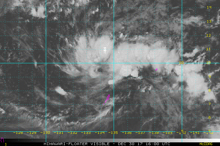
euro6208
Re: WPAC: INVEST 99W
LOW.
AN AREA OF CONVECTION (INVEST 99W) HAS PERSISTED NEAR 9.1N
135.1E, APPROXIMATELY 93 NM SOUTH-SOUTHWEST OF PALAU. ANIMATED
ENHANCED INFRARED SATELLITE IMAGERY AND A 301720Z 89GHZ SSMI F-15
MICROWAVE IMAGE SHOW AN ILL-DEFINED AND ELONGATED LOW LEVEL
CIRCULATION (LLC) WITH BROAD AND UNORGANIZED DEEP CONVECTION.
UPPER LEVEL ANALYSIS INDICATES THAT THE SYSTEM IS LOCATED IN AN AREA
OF LIGHT (5-10 KNOTS) VERTICAL WIND SHEAR WITH DECENT DIFFLUENCE
ALOFT. 99W IS LOCATED IN AN AREA OF WARM SEA SURFACE TEMPERATURES
(30-31 CELSIUS) THAT WILL SUPPORT FURTHER DEVELOPMENT. GLOBAL MODELS
ARE IN AGREEMENT THAT THE SYSTEM WILL TRACK TO THE WEST, BUT ARE
SPLIT ON THE TIMING AND INTENSIFICATION. MAXIMUM SUSTAINED SURFACE
WINDS ARE ESTIMATED AT 10 TO 15 KNOTS. MINIMUM SEA LEVEL PRESSURE IS
ESTIMATED TO BE NEAR 1006 MB. THE POTENTIAL FOR THE DEVELOPMENT OF A
SIGNIFICANT TROPICAL CYCLONE WITHIN THE NEXT 24 HOURS IS LOW.
0 likes
-
xtyphooncyclonex
- Category 5
- Posts: 3891
- Age: 24
- Joined: Sat Dec 08, 2012 9:07 am
- Location: Cebu City
- Contact:
Re: WPAC: INVEST 99W
This is moving slower than what the GFS and ECMWF have been showing in their recent runs. This now has more time to consolidate in the very warm Philippine Sea before making landfall over Visayas/Northern Mindanao. Not so much of a great start to 2018.
0 likes
REMINDER: My opinions that I, or any other NON Pro-Met in this forum, are unofficial. Please do not take my opinions as an official forecast and warning. I am NOT a meteorologist. Following my forecasts blindly may lead to false alarm, danger and risk if official forecasts from agencies are ignored.
-
xtyphooncyclonex
- Category 5
- Posts: 3891
- Age: 24
- Joined: Sat Dec 08, 2012 9:07 am
- Location: Cebu City
- Contact:
Re: WPAC: INVEST 99W
(1) AN AREA OF CONVECTION (INVEST 99W) PREVIOUSLY LOCATED NEAR
9.1N 135.1E, IS NOW LOCATED NEAR 9.3N 134.7E, APPROXIMATELY 113 NM
NORTH OF PALAU. ANIMATED MULTISPECTRAL SATELLITE IMAGERY AND A
302303Z 89GHZ AMSU PARTIAL MICROWAVE IMAGE SHOW A SLOWLY
CONSOLIDATING LOW LEVEL CIRCULATION CENTER (LLCC) WITH PERSISTENT
CONVECTION. UPPER LEVEL ANALYSIS INDICATES THAT THE SYSTEM IS
LOCATED IN AN AREA OF LIGHT (5-10 KNOTS) VERTICAL WIND SHEAR WITH
FAVORABLE RADIAL FLOW. THE DISTURBANCE IS LOCATED IN AN AREA WITH
SUPPORTIVE SEA SURFACE TEMPERATURES (30-31 CELSIUS). DYNAMIC MODELS
AGREE THAT THE SYSTEM WILL TRACK WEST, BUT ARE INDECISIVE ON TIMING
AND INTENSIFICATION. MAXIMUM SUSTAINED SURFACE WINDS ARE ESTIMATED
AT 15 TO 20 KNOTS. MINIMUM SEA LEVEL PRESSURE IS ESTIMATED TO BE
NEAR 1006 MB. THE POTENTIAL FOR THE DEVELOPMENT OF A SIGNIFICANT
TROPICAL CYCLONE WITHIN THE NEXT 24 HOURS IS UPGRADED TO MEDIUM.
0 likes
REMINDER: My opinions that I, or any other NON Pro-Met in this forum, are unofficial. Please do not take my opinions as an official forecast and warning. I am NOT a meteorologist. Following my forecasts blindly may lead to false alarm, danger and risk if official forecasts from agencies are ignored.
-
xtyphooncyclonex
- Category 5
- Posts: 3891
- Age: 24
- Joined: Sat Dec 08, 2012 9:07 am
- Location: Cebu City
- Contact:
Re: WPAC: INVEST 99W
Looking much better organized than yesterday. An evident circulation over very light wind shear means my confidence on development is high for the next 24 hours. I wouldn't be surprised if we'd see a TCFA by tonight, and this becoming Wilma before January 1. It's likely we could even see Bolaven by tomorrow.

0 likes
REMINDER: My opinions that I, or any other NON Pro-Met in this forum, are unofficial. Please do not take my opinions as an official forecast and warning. I am NOT a meteorologist. Following my forecasts blindly may lead to false alarm, danger and risk if official forecasts from agencies are ignored.
-
Digital-TC-Chaser
Re: WPAC: INVEST 99W


sims

Code: Select all
               *   HWRF  2017123100   *
               *   WP99  INVEST       *

                ------------------------------------------------------     STORM DATA     ----------------------------------------------------------

NTIME 022
TIME    (HR)         0     6    12    18    24    30    36    42    48    54    60    66    72    78    84    90    96   102   108   114   120   126
LAT     (DEG)      8.8   9.2   9.2   9.4   9.3   8.9   8.9   9.0   9.1   9.1   9.4   9.8  10.4  11.0  11.8  13.0  14.2  15.3  15.9  16.5  17.0  17.7
LON     (DEG)    133.7 131.9 130.9 130.3 128.8 127.2 125.7 124.1 122.1 120.7 119.3 117.8 116.2 115.0 114.3 113.4 112.8 112.5 112.5 112.7 113.1 113.3
MAXWIND (KT)        30    30    31    34    42    45    47    45    62    62    54    51    56    59    54    52    49    52    52    41    39    36
RMW     (KM)       119    73    59   151   155   141   139    88     5    50   163    42    42   134   140    24   117   154    92   139   127   128
MIN_SLP (MB)      1007  1005  1005  1002  1000   991   992   993   988   984   989   990   989   986   990   991   992   988   989   992   997   997
SHR_MAG (KT)         4     7     8     4     6     7     8     8    11    17    17    17    17    19    18    15    14    16    17    20    22    25
1 likes
-
euro6208

Who is online
Users browsing this forum: No registered users and 22 guests