ECMWF will have ocean coupling as part of the upgrade this model will go thru soon.
Ocean coupling is implemented by allowing different variables in the ocean, wave and atmospheric models to affect each other.
These include surface roughness from the wave model, sea-surface temperatures and surface currents from the ocean model and winds and heat fluxes from the atmospheric model.
Coupling is already operational for ECMWF’s ensemble forecasts (ENS, horizontal resolution of 18 km) and is due to be extended to high-resolution forecasts (HRES, horizontal resolution of 9 km) in the next upgrade of ECMWF’s Integrated Forecasting System (IFS).
https://www.ecmwf.int/en/about/media-ce ... -forecasts
2018 Tropics: Global Model Runs Discussion (Out to day 16)
Moderator: S2k Moderators
Forum rules

The posts in this forum are NOT official forecasts and should not be used as such. They are just the opinion of the poster and may or may not be backed by sound meteorological data. They are NOT endorsed by any professional institution or STORM2K. For official information, please refer to products from the National Hurricane Center and National Weather Service.
-
cycloneye

- Admin

- Posts: 149334
- Age: 69
- Joined: Thu Oct 10, 2002 10:54 am
- Location: San Juan, Puerto Rico
Re: 2018 Tropics: Global Model Runs Discussion (Out to day 16)
0 likes
Visit the Caribbean-Central America Weather Thread where you can find at first post web cams,radars
and observations from Caribbean basin members Click Here
and observations from Caribbean basin members Click Here
-
cycloneye
- Admin
- Posts: 149334
- Age: 69
- Joined: Thu Oct 10, 2002 10:54 am
- Location: San Juan, Puerto Rico
Re: 2018 Tropics: Global Model Runs Discussion (Out to day 16)
Umm,Maybe Subtropical Alberto?
@RyanMaue
GFS 12z develops a weak but definite subtropical storm around 30°N latitude. Several days away but the pattern fits & water is plenty warm for type of energetics necessary for a "warm core" transition.
https://twitter.com/RyanMaue/status/951510624034611200
@RyanMaue
GFS 12z develops a weak but definite subtropical storm around 30°N latitude. Several days away but the pattern fits & water is plenty warm for type of energetics necessary for a "warm core" transition.
https://twitter.com/RyanMaue/status/951510624034611200
1 likes
Visit the Caribbean-Central America Weather Thread where you can find at first post web cams,radars
and observations from Caribbean basin members Click Here
and observations from Caribbean basin members Click Here
-
TheStormExpert
Re: 2018 Tropics: Global Model Runs Discussion (Out to day 16)
Lets all hope for a full-blown El Niño this year. The record warm Atlantic SST's and the models picking up on quick phantom spin-ups like this on the 12z GFS along with the low off Florida concern me.
3 likes
-
NotSparta

- Professional-Met

- Posts: 1677
- Age: 24
- Joined: Fri Aug 18, 2017 8:24 am
- Location: Naples, FL
- Contact:
Re: 2018 Tropics: Global Model Runs Discussion (Out to day 16)
TheStormExpert wrote:Lets all hope for a full-blown El Niño this year. The record warm Atlantic SST's and the models picking up on quick phantom spin-ups like this on the 12z GFS along with the low off Florida concern me.
Yeah I think a 2006 style El Nino is the best we can get (will take time to come down from a near moderate Nina, leading to an average season (warmer SSTs than 2006)
It's unlikely that we have a repeat of this year, but if another weak Nina or cool neutral sets up, watch out
1 likes
This post was probably an opinion of mine, and in no way is official. Please refer to http://www.hurricanes.gov for official tropical analysis and advisories.
My website, with lots of tropical wx graphics, including satellite and recon: http://cyclonicwx.com
My website, with lots of tropical wx graphics, including satellite and recon: http://cyclonicwx.com
-
TheStormExpert
Re: 2018 Tropics: Global Model Runs Discussion (Out to day 16)
NotSparta wrote:TheStormExpert wrote:Lets all hope for a full-blown El Niño this year. The record warm Atlantic SST's and the models picking up on quick phantom spin-ups like this on the 12z GFS along with the low off Florida concern me.
Yeah I think a 2006 style El Nino is the best we can get (will take time to come down from a near moderate Nina, leading to an average season (warmer SSTs than 2006)
It's unlikely that we have a repeat of this year, but if another weak Nina or cool neutral sets up, watch out
2017 was a neutral season the La Niña didn't even get going until just last month I believe. Neutral seasons are the worst, they usually favor higher impacts too, take 2005 for example it was neutral.
3 likes
-
cycloneye
- Admin
- Posts: 149334
- Age: 69
- Joined: Thu Oct 10, 2002 10:54 am
- Location: San Juan, Puerto Rico
Re: 2018 Tropics: Global Model Runs Discussion (Out to day 16)
Levi Cowan models section for Tropical Cyclone soundings has new tool for shear to look at.Check it out.
@TropicalTidbits
Few updates to TC soundings. Parameter list now includes shear vector & deep-layer steering arrows. A "max shear" metric has been added, defined as max shear vector from any layer of at least 100mb depth between 850mb & 150mb. Hodograph now in hPa for easy shear interpretation.

https://twitter.com/TropicalTidbits/status/957419214591217664
@TropicalTidbits
Few updates to TC soundings. Parameter list now includes shear vector & deep-layer steering arrows. A "max shear" metric has been added, defined as max shear vector from any layer of at least 100mb depth between 850mb & 150mb. Hodograph now in hPa for easy shear interpretation.
https://twitter.com/TropicalTidbits/status/957419214591217664
1 likes
Visit the Caribbean-Central America Weather Thread where you can find at first post web cams,radars
and observations from Caribbean basin members Click Here
and observations from Caribbean basin members Click Here
-
NotSparta
- Professional-Met
- Posts: 1677
- Age: 24
- Joined: Fri Aug 18, 2017 8:24 am
- Location: Naples, FL
- Contact:
Re: 2018 Tropics: Global Model Runs Discussion (Out to day 16)
GFS keeps making a CATL cyclone into an STC in the near term

0 likes
This post was probably an opinion of mine, and in no way is official. Please refer to http://www.hurricanes.gov for official tropical analysis and advisories.
My website, with lots of tropical wx graphics, including satellite and recon: http://cyclonicwx.com
My website, with lots of tropical wx graphics, including satellite and recon: http://cyclonicwx.com
-
cycloneye
- Admin
- Posts: 149334
- Age: 69
- Joined: Thu Oct 10, 2002 10:54 am
- Location: San Juan, Puerto Rico
Re: 2018 Tropics: Global Model Runs Discussion (Out to day 16)
More new tools in the Levi Cowan section of models,this time for HWRF.
@TropicalTidbits
Website update: Soundings are now available for HWRF, both nest and parent, because you know you've always wanted to poke around inside an eyewall!
The new code also means you can measure things like eye diameter using *shift + click & drag*
Enjoy.
https://www.tropicaltidbits.com/analysi ... model=hwrf
https://twitter.com/TropicalTidbits/status/958136087179878401
2 likes
Visit the Caribbean-Central America Weather Thread where you can find at first post web cams,radars
and observations from Caribbean basin members Click Here
and observations from Caribbean basin members Click Here
-
cycloneye
- Admin
- Posts: 149334
- Age: 69
- Joined: Thu Oct 10, 2002 10:54 am
- Location: San Juan, Puerto Rico
Re: 2018 Tropics: Global Model Runs Discussion (Out to day 16)
Looks like the new FV3GFS after the upcomming upgrade will be a very different version from the current one and will be at the top with ECMWF on performance.
http://www.noaa.gov/media-release/noaa- ... er-upgrade
@EricBlake12
The nuts and bolts of the FV3GFS are fascinating- big changes from the current GFS

https://twitter.com/EricBlake12/status/973567252497920000
@EricBlake12
Quite an intensity improvement noted on the FV3 tests- much better than the current GFS but lags HWRF

https://twitter.com/EricBlake12/status/973568870991753216
@EricBlake12
The FV3 did well for Harvey intensification in comparison to the GFS

https://twitter.com/EricBlake12/status/973568099243962368
http://www.noaa.gov/media-release/noaa- ... er-upgrade
@EricBlake12
The nuts and bolts of the FV3GFS are fascinating- big changes from the current GFS
https://twitter.com/EricBlake12/status/973567252497920000
@EricBlake12
Quite an intensity improvement noted on the FV3 tests- much better than the current GFS but lags HWRF
https://twitter.com/EricBlake12/status/973568870991753216
@EricBlake12
The FV3 did well for Harvey intensification in comparison to the GFS
https://twitter.com/EricBlake12/status/973568099243962368
3 likes
Visit the Caribbean-Central America Weather Thread where you can find at first post web cams,radars
and observations from Caribbean basin members Click Here
and observations from Caribbean basin members Click Here
-
cycloneye
- Admin
- Posts: 149334
- Age: 69
- Joined: Thu Oct 10, 2002 10:54 am
- Location: San Juan, Puerto Rico
Re: 2018 Tropics: Global Model Runs Discussion (Out to day 16)
Levi Cowan continues to add more tools to the tropical areas in his site.
https://www.tropicaltidbits.com/analysis/models/
@TropicalTidbits
Added a couple new cross section types today. Trying to round out the suite of tools for 3D analysis of the atmosphere. Check 'em out!
Here's a jet core and a tropical cyclone:

https://twitter.com/TropicalTidbits/status/973718776586932225
https://www.tropicaltidbits.com/analysis/models/
@TropicalTidbits
Added a couple new cross section types today. Trying to round out the suite of tools for 3D analysis of the atmosphere. Check 'em out!
Here's a jet core and a tropical cyclone:
https://twitter.com/TropicalTidbits/status/973718776586932225
1 likes
Visit the Caribbean-Central America Weather Thread where you can find at first post web cams,radars
and observations from Caribbean basin members Click Here
and observations from Caribbean basin members Click Here
-
gatorcane

- S2K Supporter

- Posts: 23708
- Age: 48
- Joined: Sun Mar 13, 2005 3:54 pm
- Location: Boca Raton, FL
Re: 2018 Tropics: Global Model Runs Discussion (Out to day 16)
Looks like the past two runs of the ECMWF develop some surface low in the South-Central Gulf at the base of an upper trough swinging through the Southern US that looks to have some subtropical characteristics. Here is how the 12Z run ends at 10 days as it moves NE towards Florida:

1 likes
-
Weather150
- Tropical Storm

- Posts: 190
- Joined: Fri Jul 07, 2017 7:46 pm
Re: 2018 Tropics: Global Model Runs Discussion (Out to day 16)
gatorcane wrote:Looks like the past two runs of the ECMWF develop some surface low in the South-Central Gulf at the base of an upper trough swinging through the Southern US that looks to have some subtropical characteristics. Here is how the 12Z run ends at 10 days as it moves NE towards Florida:
Models aren't enthusiastic with that anymore.
0 likes
-
cycloneye
- Admin
- Posts: 149334
- Age: 69
- Joined: Thu Oct 10, 2002 10:54 am
- Location: San Juan, Puerto Rico
Re: 2018 Tropics: Global Model Runs Discussion (Out to day 16)
Those who may be wondering what is going on with ECMWF in the 12z run of March 28 that is delayed,here is an explanation.

1 likes
Visit the Caribbean-Central America Weather Thread where you can find at first post web cams,radars
and observations from Caribbean basin members Click Here
and observations from Caribbean basin members Click Here
-
cycloneye
- Admin
- Posts: 149334
- Age: 69
- Joined: Thu Oct 10, 2002 10:54 am
- Location: San Juan, Puerto Rico
Re: 2018 Tropics: Global Model Runs Discussion (Out to day 16)
cycloneye wrote:Those who may be wondering what is going on with ECMWF in the 12z run of March 28 that is delayed,here is an explanation.
12z ECMWF run is up.
0 likes
Visit the Caribbean-Central America Weather Thread where you can find at first post web cams,radars
and observations from Caribbean basin members Click Here
and observations from Caribbean basin members Click Here
-
cycloneye
- Admin
- Posts: 149334
- Age: 69
- Joined: Thu Oct 10, 2002 10:54 am
- Location: San Juan, Puerto Rico
Re: 2018 Tropics: Global Model Runs Discussion (Out to day 16)
For those who like to follow the spaghetti,here is a good advice.
@EricBlake12
People love to post spaghetti models on invests - remember those plots are much less accurate than when it is tropical cyclone, and you are only seeing a fraction of the guidance #nhc2018

https://twitter.com/EricBlake12/status/979338636285108225
@EricBlake12
People love to post spaghetti models on invests - remember those plots are much less accurate than when it is tropical cyclone, and you are only seeing a fraction of the guidance #nhc2018
https://twitter.com/EricBlake12/status/979338636285108225
1 likes
Visit the Caribbean-Central America Weather Thread where you can find at first post web cams,radars
and observations from Caribbean basin members Click Here
and observations from Caribbean basin members Click Here

Re: 2018 Tropics: Global Model Runs Discussion (Out to day 16)
I am sure this will take many by surprise but I thought it did really well in the Atlantic last year in the Atlantic but I am sure conditions favored that usually aggressive model 
https://twitter.com/EricBlake12/status/979380179968692225

https://twitter.com/EricBlake12/status/979380179968692225
1 likes
-
Digital-TC-Chaser
Re: 2018 Tropics: Global Model Runs Discussion (Out to day 16)
Yeah it did really well with Harvey.
0 likes
-
cycloneye
- Admin
- Posts: 149334
- Age: 69
- Joined: Thu Oct 10, 2002 10:54 am
- Location: San Juan, Puerto Rico
Re: 2018 Tropics: Global Model Runs Discussion (Out to day 16)
12z April 10.
@TropicalTidbits
The NCEP data server has been having issues today, resulting in delayed or incomplete model runs for the GFS, NAM, HRRR, and all other NCEP models. Apologies for the inconvenience.
@TropicalTidbits
The NCEP data server has been having issues today, resulting in delayed or incomplete model runs for the GFS, NAM, HRRR, and all other NCEP models. Apologies for the inconvenience.
1 likes
Visit the Caribbean-Central America Weather Thread where you can find at first post web cams,radars
and observations from Caribbean basin members Click Here
and observations from Caribbean basin members Click Here
-
Aric Dunn
- Category 5

- Posts: 21238
- Age: 43
- Joined: Sun Sep 19, 2004 9:58 pm
- Location: Ready for the Chase.
- Contact:
Re: 2018 Tropics: Global Model Runs Discussion (Out to day 16)
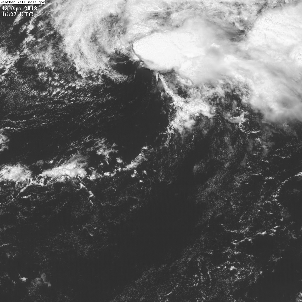
Well I dont want to make a new thread .. but someone else can.. but has no one else noticed the tropical low with sheared convection sitting east of the bahamas the last 24 hours.. I have seen worse looking TS.. lol
3 likes
Note: If I make a post that is brief. Please refer back to previous posts for the analysis or reasoning. I do not re-write/qoute what my initial post said each time.
If there is nothing before... then just ask
Space & Atmospheric Physicist, Embry-Riddle Aeronautical University,
I believe the sky is falling...
If there is nothing before... then just ask
Space & Atmospheric Physicist, Embry-Riddle Aeronautical University,
I believe the sky is falling...
-
NotSparta
- Professional-Met
- Posts: 1677
- Age: 24
- Joined: Fri Aug 18, 2017 8:24 am
- Location: Naples, FL
- Contact:
Re: 2018 Tropics: Global Model Runs Discussion (Out to day 16)
Aric Dunn wrote:Well I dont want to make a new thread .. but someone else can.. but has no one else noticed the tropical low with sheared convection sitting east of the bahamas the last 24 hours.. I have seen worse looking TS.. lol
not half bad, but it gets swept away soon
2 likes
This post was probably an opinion of mine, and in no way is official. Please refer to http://www.hurricanes.gov for official tropical analysis and advisories.
My website, with lots of tropical wx graphics, including satellite and recon: http://cyclonicwx.com
My website, with lots of tropical wx graphics, including satellite and recon: http://cyclonicwx.com
Who is online
Users browsing this forum: No registered users and 49 guests