The posts in this forum are NOT official forecast and should not be used as such. They are just the opinion of the poster and may or may not be backed by sound meteorological data. They are NOT endorsed by any professional institution or

Portastorm wrote:wxman22 wrote:Euro looks the same just with slightly less precipitation across southeast Texas, the gfs actually shows more precipitation but it’s warmer. The freezing line never gets to i-10 even once the precip has moved out,while the Euro has the freezing line reaching I-10 as early as noon Tuesday, and drops temps into the mid to low 20s overnight Tuesday . Pretty big difference in temps considering how close we are to the event. Based on history I would go with the Euro for temps before the gfs, since the gfs tends to have a warm bias when it comes to shallow air.
Nice summary. Similar issues in play to your west over here in south central Texas. For now, EWX believes the predominant forms of wintry precip for us will be freezing rain into sleet. I concur. I think snow here is more of an outlier this time.
Yeah, I think I will be closed Tuesday. This happened back in 2007 around MLK week. Had an ice event.
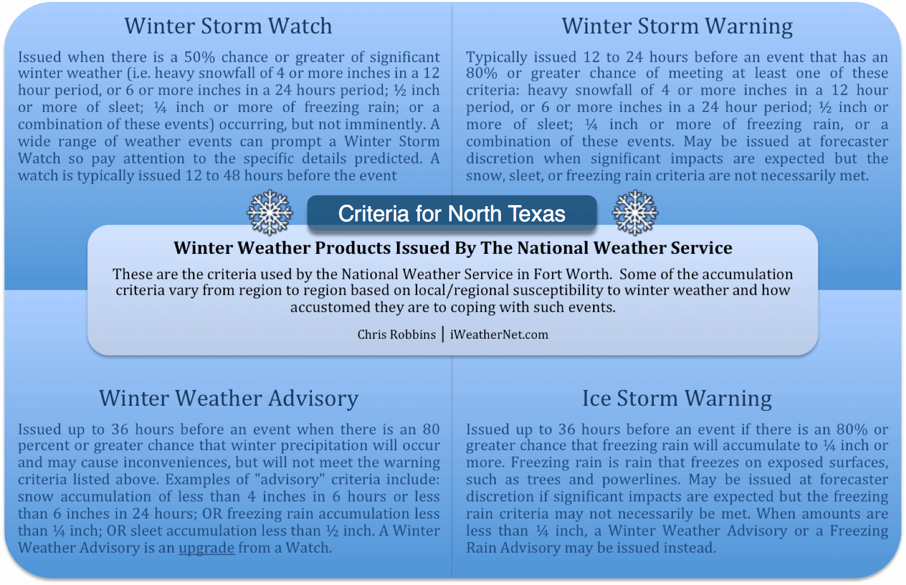
LONG TERM (Monday through Friday)...
Concern for winter weather impacts for portions of South-Central
Texas continues to grow for early morning Tuesday through Tuesday
afternoon. Models continue to suggest the likelihood of a wintry mix
of sleet, freezing rain, and possibly snow. Highest confidence of
impacts remains over the Hill Country and northern I-35 corridor
areas, including the Austin Metro. Depending on evolution and if
colder model solutions verify, then portions of San Antonio could
also be affected. The forecast discussion below will concentrate
primarily on this impact time frame as moderate travel and road
impacts could be realized depending on temperature and precipitation
evolution.
A strong and shallow Arctic front will be positioned across the
southern Plains Monday ahead of a strong surface high pressure system
in the northern Plains with a strong longwave trough over the
eastern 2/3rds of the CONUS. Southerly isentropic upglide will begin
Monday ahead of the front that will slowly saturate the low and mid-
levels. Frontal timing issues remain with the ECMWF being the fastest
but with colder temperatures, the GFS is currently the slowest and
on the warmer side of the model temperature envelope, while the NAM
is in the middle of both timing-wise but with temperatures more
similar to the ECMWF. Despite the GFS being the warmest of model
guidance, winter weather impacts still appear possible and thus the
increasing concern/confidence of winter precipitation impacts.
Precipitation will initially be all rain along and ahead of the
front late Monday night and into early Tuesday morning through 3-4am.
Thereafter however, the shallow arctic airmass will surge through
the region and drop temperatures rapidly. With isentropic lift
overtop the front, post-frontal precipitation is expected. The big
question will be how much moisture and lift will be present in
conjunction with the near-surface sub-freezing layer. Overall model
temperature profile envelope suggests sleet and freezing rain as the
predominate precipitation type early Tuesday morning through at
least noon for the Hill Country, portions of the northern I-35
corridor, which includes the Austin metro. Some snow could mix in but
dentritic growth zone appears slightly dry vs. the much more
saturated lower-levels which would support freezing rain/drizzle and
sleet mix. Going into Tuesday afternoon, models diverge on amount of
precipitation with ECMWF and NAM ending precipitation while GFS
maintains enough upglide for light amounts to persist. Despite the
light amounts, temperatures could be near or below freezing and
impacts further worsened. Have held on to low-end slight change
winter mix chances through Tuesday afternoon to account for this
possibility for now. Will not get into details on accumulations just
yet but am inclined to say that winter weather headlines will be
likely for Tuesday given current model solutions and trends. At least
slight to moderate travel and road impacts could occur.
http://forecast.weather.gov/product.php ... glossary=1