Texas Winter 2017-2018
Moderator: S2k Moderators
Forum rules
 The posts in this forum are NOT official forecast and should not be used as such. They are just the opinion of the poster and may or may not be backed by sound meteorological data. They are NOT endorsed by any professional institution or STORM2K.

The posts in this forum are NOT official forecast and should not be used as such. They are just the opinion of the poster and may or may not be backed by sound meteorological data. They are NOT endorsed by any professional institution or STORM2K.

Re: Texas Winter 2017-2018
If that line extends any further south east.. or rather if it’s any colder than nam currently forecasts or precipitation is heavier this could very well be an ice storm. As stated it’s just one model but it’s the best one handling this cold air and it’s calling for a serious ice storm tomorrow
0 likes
-
bubba hotep

- S2K Supporter

- Posts: 6014
- Joined: Wed Dec 28, 2016 1:00 am
- Location: Collin County Texas
Re: Texas Winter 2017-2018
SGJ wrote:
Bubba - What do you think about Wylie?
1st off, this is based on the 3k NAM matching reality (if that were to happen), areas closer to the lake would probably see lower accumulations.
FWD has Wylie pegged for 45 tomorrow but the 3k NAM looks like 39 with the frozen precipitation falling tomorrow evening. It looks like the high tomorrow will be the 1st thing to watch, if we bust low then things could get tricky. If the surface does get to freezing or below, then accumulation still looks tricky with a significant warm layer above. My guess, cold rain. If things trend towards the 3k NAM then FWD will have to hoist some kind of winter weather adv/watches asap because icing could start on the backside of the evening rush.
Regardless of the model output, this sounding still looks like there would be "warm" rain falling on the cold surface and that might limit accumulations. However, I have basically no experience with freezing rain, so maybe someone else will chime in regarding the thickness and overall warmth of the warm layer.

1 likes
Winter time post are almost exclusively focused on the DFW area.

Re: Texas Winter 2017-2018
Light Icing issues just NW OF Metroplex late Tomorrow .... Guys/Gals we gotta watch next weekend Winter is NOT over my friends! Operationals all over the place the devil is in the details.. Hang tight!

2 likes


-
Brent
- S2K Supporter
- Posts: 38755
- Age: 37
- Joined: Sun May 16, 2004 10:30 pm
- Location: Tulsa Oklahoma
- Contact:
Re: Texas Winter 2017-2018
Yeah im not really concerned about some big ice storm in the metroplex if were running cold tomorrow then we have issues but I'm envisioning a cold rain mostly
0 likes
#neversummer
-
missygirl810

- Tropical Storm

- Posts: 154
- Joined: Fri Oct 27, 2017 3:07 pm
- Location: Celeste TX Hunt County Fannin Co line
Re: Texas Winter 2017-2018
Looks like my area is in it. Greenville/Celeste. We border the Hunt/Fannin County lines
0 likes
Re: Texas Winter 2017-2018
I'm sorry I should have explained this a tad better with my post this is the "Ensemble run" The ensembles run using the same initial data as the GFS (global forecast system) model
but with a key difference – the model is run several times, each time with some slight changes to the original data. The reason for this is that weather forecasting models take a
huge amount of data into them, and within this data there will always be some errors and inaccuracies, so by making changes to that data you can understand how those
inaccuracies may affect the forecast. A control is also run, which is the data without any changes to it. By comparing the various outputs from each run of the model, you can also
gauge a margin for error for each forecast timeslot, which is very useful for working out how likely the shown outcome is to happen. Each time the model is run with the slightly
different data, the output it creates is known as a member.
Anytime you can get nearly half of the Ensemble runs onto something you should pay attention. For example I know not all of these are focused on DFW or say Central TX but we see several
for sure up into Oklahoma. Bottom line it raises a red flag to me that something might be in play in the Southern plains next Sunday/Monday either in OK/TX... So something to watch!
Last edited by OKMet83 on Mon Feb 05, 2018 10:32 pm, edited 1 time in total.
0 likes
-
bubba hotep
- S2K Supporter
- Posts: 6014
- Joined: Wed Dec 28, 2016 1:00 am
- Location: Collin County Texas
Re: Texas Winter 2017-2018
I don't remember what event it was, but there was one IMBY was 31 but there was a very warm layer aloft. Ice would accumulate on surfaces when there was mist or light rain but as soon as the rates picked up everything melted. We ended up with no real icing but I think areas NW did get significant icing.
1 likes
Winter time post are almost exclusively focused on the DFW area.
-
bubba hotep
- S2K Supporter
- Posts: 6014
- Joined: Wed Dec 28, 2016 1:00 am
- Location: Collin County Texas
Re: Texas Winter 2017-2018
00z GFS is about 4-6 degrees cooler across DFW tomorrow. Factor in the warm bias that the new GFS appears to have and that gets things pretty close to the 00z 3k NAM.
0 likes
Winter time post are almost exclusively focused on the DFW area.
-
bubba hotep
- S2K Supporter
- Posts: 6014
- Joined: Wed Dec 28, 2016 1:00 am
- Location: Collin County Texas
Re: Texas Winter 2017-2018
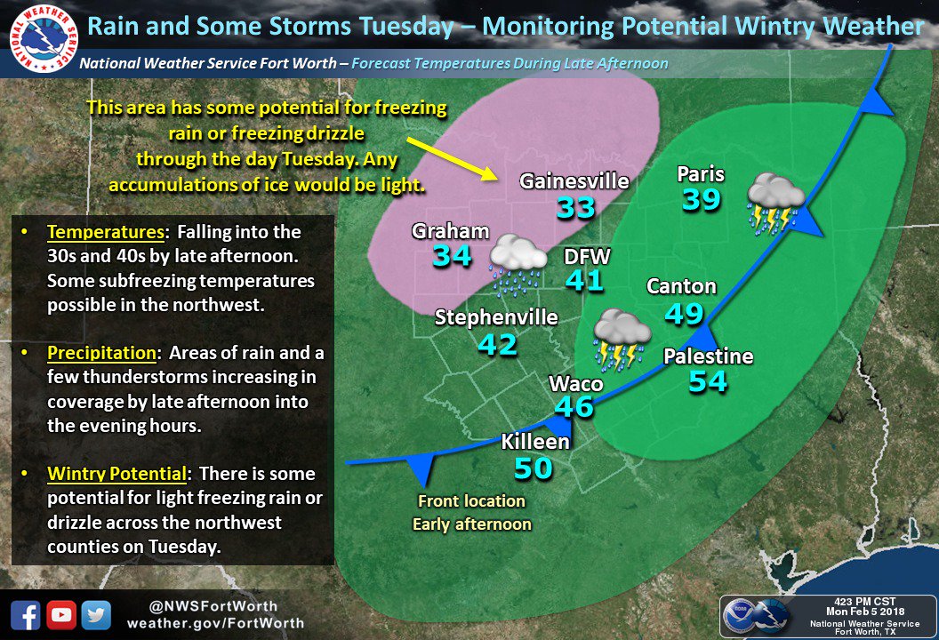
FWD lowering temps across DFW with this latest update:
000
FXUS64 KFWD 060400
AFDFWD
Area Forecast Discussion
National Weather Service Fort Worth TX
1000 PM CST Mon Feb 5 2018
.UPDATE...
Winds have become light north to northeast across most of the
forecast area this evening. Meanwhile, low clouds have temporarily
shifted to the east of a Bonham to Dallas to Lampasas line.
This has allowed temperatures to cool a bit more than we had
earlier expected along the I-35 corridor. The dense network of
observations across Tarrant County show quite a temperature
difference at 9 PM with Arlington and Fort Worth Spinks Airport
having fallen to 33 degrees while Fort Worth Meacham was reporting
43 degrees.
For Tuesday, given the expected cloud cover, have lowered
temperatures across most of the forecast area by a few degrees.
Temperatures over the northwestern zones will struggle to rise
more than a few degrees above freezing. It looks like the rain
probably won`t make it that far northwest until sometime Tuesday
afternoon, so have just left a mention of liquid rain in those
areas for now, but we will have to monitor this closely as some
light freezing rain is not out of the question.
For Tuesday night, have likewise lowered temperatures. The rain
should end mid to late evening across most areas northwest of
I-20/I-30 but areas along and northwest of an Eastland to Denton
to Bonham may fall below freezing before the precipitation ends,
thus have included R-/ZR-. At this time, it looks like amounts
should be light and temperatures will be 28 to 32 degrees. Some
light ice accumulations on elevated surfaces cannot be ruled out.
58
0 likes
Winter time post are almost exclusively focused on the DFW area.
-
Texas Snow

- S2K Supporter
- Posts: 817
- Joined: Mon Oct 19, 2015 12:06 pm
- Location: N. Dallas & Cedar Creek Lake
Re: Texas Winter 2017-2018
Yep, just read that. Should be fun to watch it play out during the day to see which way it may trend tomorrow night.
0 likes
"Don't let wishcastin get in the way of your forecastin"

-
Haris

- Category 5

- Posts: 1814
- Joined: Mon Nov 27, 2017 8:19 pm
- Location: ( Bee Cave) West Austin, Texas
Re: Texas Winter 2017-2018
I am suprised their is no chatter about the latest Canadian model ice storm on sat here
0 likes
Weather geek and a storm spotter in West Austin. Not a degreed meteorologist. Big snow fan. Love rain and cold! Despise heat!
-
orangeblood
- S2K Supporter
- Posts: 3895
- Joined: Tue Dec 15, 2009 6:14 pm
- Location: Fort Worth, TX
Re: Texas Winter 2017-2018
GFS starting to trend towards CMC for this weekend...stronger HP with a good trajectory for the southern plains. Still suspect with the front positioning though, CMC looks more realistic. STJ gets thrown into the mix with trough digging SW, about time - we've waited way too long.
If models are even remotely close to accurate at 500mb, this might be the best setup we've had in a couple of years
If models are even remotely close to accurate at 500mb, this might be the best setup we've had in a couple of years
Last edited by orangeblood on Mon Feb 05, 2018 11:27 pm, edited 1 time in total.
0 likes
-
bubba hotep
- S2K Supporter
- Posts: 6014
- Joined: Wed Dec 28, 2016 1:00 am
- Location: Collin County Texas
Re: Texas Winter 2017-2018
Haris wrote:I am suprised their is no chatter about the latest Canadian model ice storm on sat here
Canadian has a terrible cold bias but the ICON and GFS aren't too far off on that potential event.
0 likes
Winter time post are almost exclusively focused on the DFW area.
Re: Texas Winter 2017-2018
Just as an example looking at Sherman current temperature 32f and the low according to nws is 35. With that being said looks like we are in for a wild ride over the next week
0 likes
-
SouthernMet

- Category 3

- Posts: 857
- Joined: Sun Aug 29, 2010 8:23 pm
- Location: fort worth, tx
Re: Texas Winter 2017-2018
Jarodm12 wrote:Just as an example looking at Sherman current temperature 32f and the low according to nws is 35. With that being said looks like we are in for a wild ride over the next week
Fw Alliance had a low of 39 and it’s 29 now.
0 likes
Nothing that SouthernMet posts, is an official forecast,nor does it reflect views of STORM2K.. SouthernMet is just adding to the great discussions on STORM2K.. Refer to NWS for official forecasts.
-
Lagreeneyes03
- Category 2

- Posts: 610
- Joined: Mon Dec 09, 2013 10:53 am
- Location: Luxurious Lake Grapevine
Re: Texas Winter 2017-2018
SouthernMet wrote:Shocked at the crickets in here. NAM showing pretty significant ice accumulations across north texas tomorrow evening. Shows a widespread .5” for Johnson, Somerville, Bosque counties and .2” across Tarrant county. As many of us know, it doesn’t take much ice to knock down trees and power lines.
I'm up in OKC for work this week, and they are calling for possible ice tomorrow afternoon here, what do you all think about that for up this way? Wondering if we'll end up stranded somewhere, which won't be fun
0 likes
I'm a Princess, not a forecaster.
-
Brent
- S2K Supporter
- Posts: 38755
- Age: 37
- Joined: Sun May 16, 2004 10:30 pm
- Location: Tulsa Oklahoma
- Contact:
Re: Texas Winter 2017-2018
The NAM is sticking to the surprise DFW Ice storm tonight especially NW half of the metro
HRRR Is warmer than the NAM through 0z and the ice is far from DFW(when the NAM already has ice in the metro)
HRRR Is warmer than the NAM through 0z and the ice is far from DFW(when the NAM already has ice in the metro)
0 likes
#neversummer
-
srainhoutx

- S2K Supporter
- Posts: 6919
- Age: 68
- Joined: Sun Jan 14, 2007 11:34 am
- Location: Haywood County, NC
- Contact:
Re: Texas Winter 2017-2018
The upcoming weekend is looking very wet across portions of S Central, SE, E Texas into Louisiana. Concern growing for the potential of heavy rainfall as Coastal low/trough organizes near Brownsville/Corpus Christi with a deep SW trough seen on all the Global Ensembles as well as a Baja low meandering across Mexico into Texas. Embedded disturbance riding the sub tropical jet suggest rainfall with possibly some heavy thunderstorms develop Friday and continue into Saturday. Rainfall could continue into Sunday before we finally see a brief break before another front approaches. Rollercoaster Pattern continues.
1 likes
Carla/Alicia/Jerry(In The Eye)/Michelle/Charley/Ivan/Dennis/Katrina/Rita/Wilma/Ike/Harvey
Member: National Weather Association
Wx Infinity Forums
http://wxinfinity.com/index.php
Facebook.com/WeatherInfinity
Twitter @WeatherInfinity
Member: National Weather Association
Wx Infinity Forums
http://wxinfinity.com/index.php
Facebook.com/WeatherInfinity
Twitter @WeatherInfinity
Who is online
Users browsing this forum: No registered users and 165 guests