2018 WPAC Season
Moderator: S2k Moderators
Forum rules

The posts in this forum are NOT official forecasts and should not be used as such. They are just the opinion of the poster and may or may not be backed by sound meteorological data. They are NOT endorsed by any professional institution or STORM2K. For official information, please refer to products from the National Hurricane Center and National Weather Service.
-
euro6208
Re: 2018 WPAC Season
This MJO does wonders. 2 TC's in historically the most quietest month of the season?
1 likes
-
euro6208
Re: 2018 WPAC Season
EURO now in agreement with GFS on landfall location but differs on how strong it will get. Keeps it weak 3rd run in a row.


0 likes
-
euro6208
Re: 2018 WPAC Season
Looking like development is looking less and less likely now. It's greatest chance would be in the SCS.
0 likes
-
euro6208
Re: 2018 WPAC Season
1900hurricane wrote:While we wait for the 2018 Typhoon Season to kick into gear, feel free to check out the reanalysis I did on the 1979 Typhoon Season, which I have summarized in a recent blog entry.
Reanalyzing the Pacific Typhoon Seasons: 1979
Great blog! Measured 898 and 887 mb but only 130 and 135 knots max? That's thrilling. Looking more to your reanalysis post!
1 likes

-
1900hurricane

- Category 5

- Posts: 6063
- Age: 34
- Joined: Fri Feb 06, 2015 12:04 pm
- Location: Houston, TX
- Contact:
Re: 2018 WPAC Season
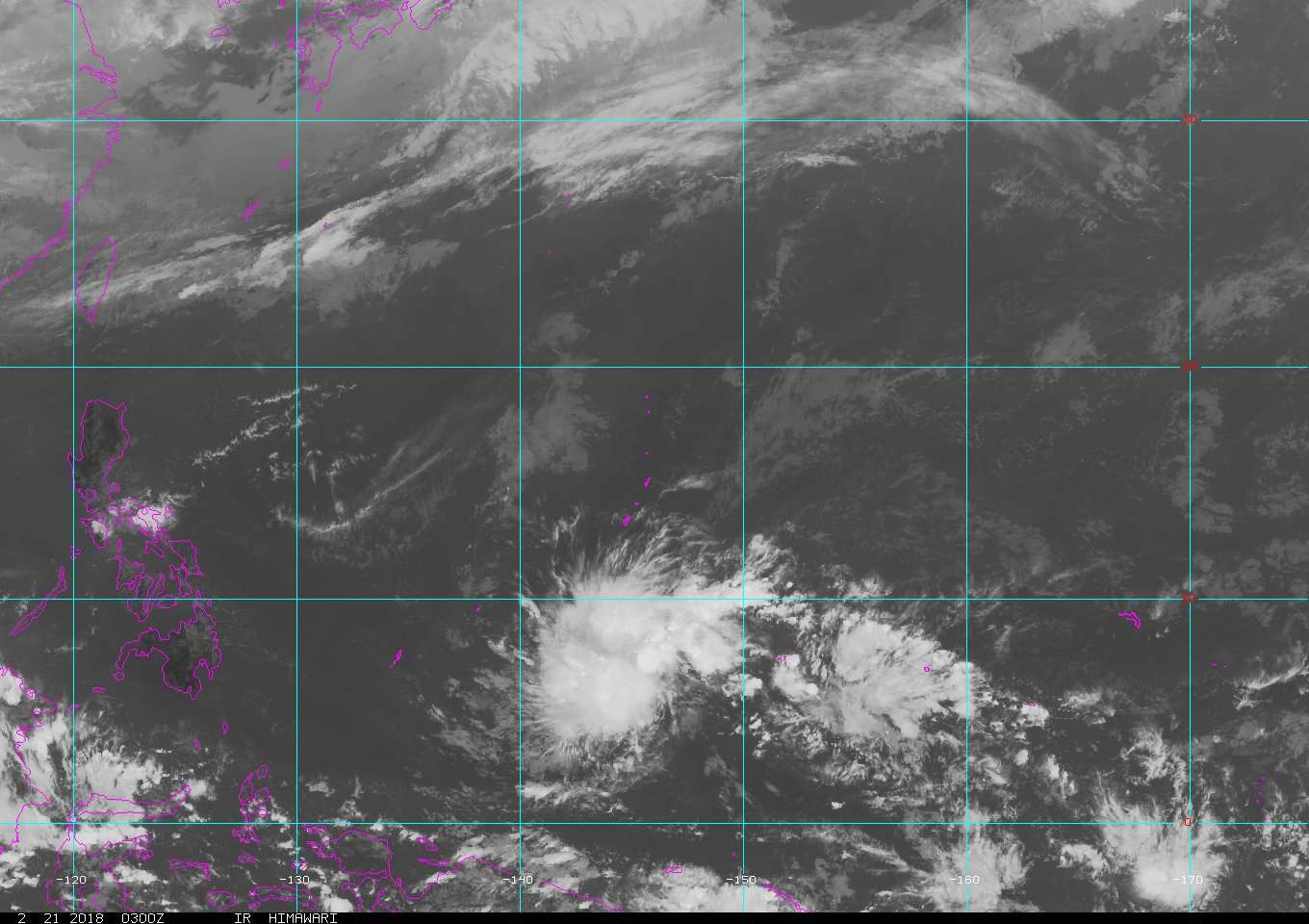
Anything that develops will come from the feature in the vicinity of 5ºN and 158ºE. Some weak equatorial westerlies interacting with the trade winds has resulted in a loose area of vorticity. ASCAT from several hours ago showed cyclonic curvature to the wind barbs to the west of 160ºE, and IR imagery from the area also shows some slight curvature to the scattered disorganized convection. Guidance has backed off some with the feature, keeping it open through at least tau 120. I'm not expecting development, but it's the only game in town right now as we navigate through the WPac climatological minimum in tropical cyclone activity. It will probably be tagged as an invest at some point though.


0 likes
Contract Meteorologist. TAMU & MSST. Fiercely authentic, one of a kind. We are all given free will, so choose a life meant to be lived. We are the Masters of our own Stories.
Opinions expressed are mine alone.
Follow me on Twitter at @1900hurricane : Read blogs at https://1900hurricane.wordpress.com/
Opinions expressed are mine alone.
Follow me on Twitter at @1900hurricane : Read blogs at https://1900hurricane.wordpress.com/
-
mrbagyo

- Category 5
- Posts: 3963
- Age: 33
- Joined: Thu Apr 12, 2012 9:18 am
- Location: 14.13N 120.98E
- Contact:
Re: 2018 WPAC Season
a new invest is about to get tagged
0 likes
The posts in this forum are NOT official forecast and should not be used as such. They are just the opinion of the poster and may or may not be backed by sound meteorological data. They are NOT endorsed by any professional institution or storm2k.org. For official information, please refer to RSMC, NHC and NWS products.
-
euro6208
-
euro6208
Re: 2018 WPAC Season
Interesting. GFS has a small tight vortex developing near 145E and crosses the equator to the Southern Hemisphere. Short lived.


0 likes
-
1900hurricane
- Category 5
- Posts: 6063
- Age: 34
- Joined: Fri Feb 06, 2015 12:04 pm
- Location: Houston, TX
- Contact:
Re: 2018 WPAC Season
Looks spurious to me.
0 likes
Contract Meteorologist. TAMU & MSST. Fiercely authentic, one of a kind. We are all given free will, so choose a life meant to be lived. We are the Masters of our own Stories.
Opinions expressed are mine alone.
Follow me on Twitter at @1900hurricane : Read blogs at https://1900hurricane.wordpress.com/
Opinions expressed are mine alone.
Follow me on Twitter at @1900hurricane : Read blogs at https://1900hurricane.wordpress.com/
-
Digital-TC-Chaser
Re: 2018 WPAC Season
From anticlockwise to clockwise. Not possible we move forward in the shem not in reverse 
Euro is just pointing it out. He knows it's fake.
Euro is just pointing it out. He knows it's fake.
0 likes
-
euro6208
Re: 2018 WPAC Season

At this time, AccuWeather is projecting the number of tropical storms, typhoons and super typhoons to be near to slightly below average for 2018
It's going to be another long season ahead whether nina, nino, or neutral. With nino, you have a much more favorable environment with countless areas threatened. With nina, the focus will be around the Philippines and SCS where all that warm water is concentrated. Oh boy.
2018 season forecast
0 likes
-
cycloneye

- Admin

- Posts: 149368
- Age: 69
- Joined: Thu Oct 10, 2002 10:54 am
- Location: San Juan, Puerto Rico
2018 Tropics: Global Model Runs Discussion (Out to day 16)
Long range here so take it with extreme caution as GFS has a TS/Typhoon closing on Mindanao,Phillippines.

0 likes
Visit the Caribbean-Central America Weather Thread where you can find at first post web cams,radars
and observations from Caribbean basin members Click Here
and observations from Caribbean basin members Click Here
-
euro6208
Re: 2018 WPAC Season
GFS very persistent on this area had it crossing south of the equator to some runs almost no development as it nears the P.I. Bullish now.
Let's see what happens.
Let's see what happens.
0 likes
-
euro6208
Re: 2018 WPAC Season
GFS not as strong and is on and off about this future system in past couple of runs. Some runs has it moving towards Guam others passing south of Guam.
0 likes
-
dexterlabio
- Category 5
- Posts: 3505
- Joined: Sat Oct 24, 2009 11:50 pm
Re: 2018 WPAC Season
I just wish the GFS undergoes some kind of update before the typhoon season kicks in. I know long-range model storms are always suspicious, but there was a time that the GFS could nail potential systems 300+ hours out. I believe that model worked really well back in 2013.
0 likes
Personal Forecast Disclaimer:
The posts in this forum are NOT official forecast and should not be used as such. They are just the opinion of the poster and may or may not be backed by sound meteorological data. They are NOT endorsed by any professional institution or storm2k.org. For official information, please refer to the NHC and NWS products.
The posts in this forum are NOT official forecast and should not be used as such. They are just the opinion of the poster and may or may not be backed by sound meteorological data. They are NOT endorsed by any professional institution or storm2k.org. For official information, please refer to the NHC and NWS products.
-
euro6208
Re: 2018 WPAC Season
GFS back at it again this time an eastward strengthening typhoon over eastern Micronesia? I think not...Latest runs again weaker and moving west.
0 likes
-
euro6208
Re: 2018 WPAC Season
EURO joins GFS on something developing southeast of Guam for the past 5 runs but further development is limited. Passes south of Guam while GFS is not as enthusiastic as previous.


1 likes
-
euro6208
Re: 2018 WPAC Season


.Eastern Micronesia...
A very active pattern persists across the region with a poorly-
defined circulation south-southeast of Pohnpei near 4N160E.
Widespread showers and some thunderstorms span much of Pohnpei and
Kosrae States. Models maintain similar weather for Pohnpei for
much of the next several days while Kosrae may see a little
reduction in convection by Thursday night. However, models show
little change in organization or motion of the circulation so
unstable weather will remain in the area for a while. Trade-wind
convergence will bring scattered showers to Majuro Thursday and
Thursday night.
&&
.Western Micronesia...
Chuuk weather will remain fairly quiet through tonight, but a few
isolated thunderstorms are possible by Thursday as convection
associated with the weak circulation SSE of Pohnpei moves into the
area. Scattered showers are expected on Friday, but for the long
run, models keep the bulk of precipitation to the east through
the weekend.
Quiet weather at Yap and Koror will continue through the weekend.
Trade-wind convergence will bring a few more clouds and showers to
the area by Thursday night or Friday. High surf advisory remains
in effect through Thursday night. North swell will gradually
subside with the dominant swell becoming more easterly by Friday.
0 likes
Who is online
Users browsing this forum: No registered users and 139 guests