First attempts out west along the dryline and near the somewhat ill defined triple poin
https://twitter.com/whatisthisrds/status/975448226424934405
Texas Spring 2018
Moderator: S2k Moderators
Forum rules

The posts in this forum are NOT official forecast and should not be used as such. They are just the opinion of the poster and may or may not be backed by sound meteorological data. They are NOT endorsed by any professional institution or STORM2K.
-
bubba hotep

- S2K Supporter

- Posts: 6014
- Joined: Wed Dec 28, 2016 1:00 am
- Location: Collin County Texas
-
Haris

- Category 5

- Posts: 1814
- Joined: Mon Nov 27, 2017 8:19 pm
- Location: ( Bee Cave) West Austin, Texas
Re: Texas Spring 2018
Uhhhh 12z Euro anyone ???
Just a typical panhandle snowstorm and massive rain event for the entire state with cape near 3000 and severe weather
Just a typical panhandle snowstorm and massive rain event for the entire state with cape near 3000 and severe weather
3 likes
Weather geek and a storm spotter in West Austin. Not a degreed meteorologist. Big snow fan. Love rain and cold! Despise heat!
-
bubba hotep
- S2K Supporter
- Posts: 6014
- Joined: Wed Dec 28, 2016 1:00 am
- Location: Collin County Texas
Re: Texas Spring 2018
Haris wrote:Uhhhh 12z Euro anyone ???
Just a typical panhandle snowstorm and massive rain event for the entire state with cape near 3000 and severe weather
9" rain max just east of DFW lol. That looks like '15 when DFW had tons of rain but there was significant flooding in SE Oklahoma. Beavers Bend state park took several years to fully repair damaged roads and bridges.
1 likes
Winter time post are almost exclusively focused on the DFW area.
-
bubba hotep
- S2K Supporter
- Posts: 6014
- Joined: Wed Dec 28, 2016 1:00 am
- Location: Collin County Texas
Re: Texas Spring 2018
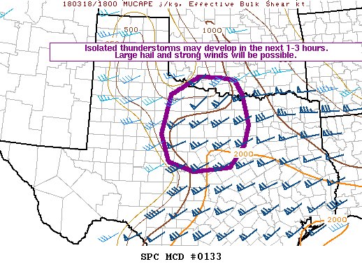
Mesoscale Discussion 0133
NWS Storm Prediction Center Norman OK
0233 PM CDT Sun Mar 18 2018
Areas affected...Western north Texas and far southwest/south-central
Oklahoma
Concerning...Severe potential...Watch possible
Valid 181933Z - 182130Z
Probability of Watch Issuance...40 percent
SUMMARY...Isolated thunderstorms may develop across portions of
western north Texas and far southwest Oklahoma over the next several
hours. Any thunderstorm that develops should move generally east
toward the I-35 corridor, posing a risk for large hail and strong
winds, although a tornado or two will be possible with any sustained
thunderstorms.
DISCUSSION...Visible satellite imagery indicates thinning/clearing
clouds across western north Texas in the wake of morning
clouds/precipitation. Strong heating in the wake of the clouds has
allowed for cumulus development on the dryline near its intersection
with a weak surface front that extends northeast into southern
Oklahoma. Additional cumulus development is noted along the
aforementioned surface front as far northeast as far southwest
Oklahoma.
Current indications are that afternoon insolation will combine with
continued low-level moistening to allow for isolated thunderstorms
to develop out of these increasingly agitated cumulus fields over
the next several hours. Steep/steepening midlevel-lapse rates will
support most-unstable CAPE ranging from 1000-2500 J/kg at the same
time a strong mid-level jet moves across the region supporting
effective-layer shear on the order of 50-70 knots. This environment
will support a supercell threat with any thunderstorm that can
develop and become sustained. Large hail and strong winds will be
the primary threats initially. The tornado threat will slowly
increase this evening as the low-level jet increases and storms move
east into the better low-level moisture.
..Marsh/Guyer.. 03/18/2018
0 likes
Winter time post are almost exclusively focused on the DFW area.

Re: Texas Spring 2018
Ummm, this is interesting. Can someone tell me why on the GFS it has the bulk of the rain mostly east of Texas and the CPC has it over Texas?

0 likes
-
bubba hotep
- S2K Supporter
- Posts: 6014
- Joined: Wed Dec 28, 2016 1:00 am
- Location: Collin County Texas
Re: Texas Spring 2018
Latest HRRR tracks a single supercell right across DFW and the 18z 3k NAM is now firing storms.
0 likes
Winter time post are almost exclusively focused on the DFW area.
-
bubba hotep
- S2K Supporter
- Posts: 6014
- Joined: Wed Dec 28, 2016 1:00 am
- Location: Collin County Texas
Re: Texas Spring 2018
The 18z FWD sounding showed 1,100+ MU and with breaks in the clouds that number is probably still climbing.
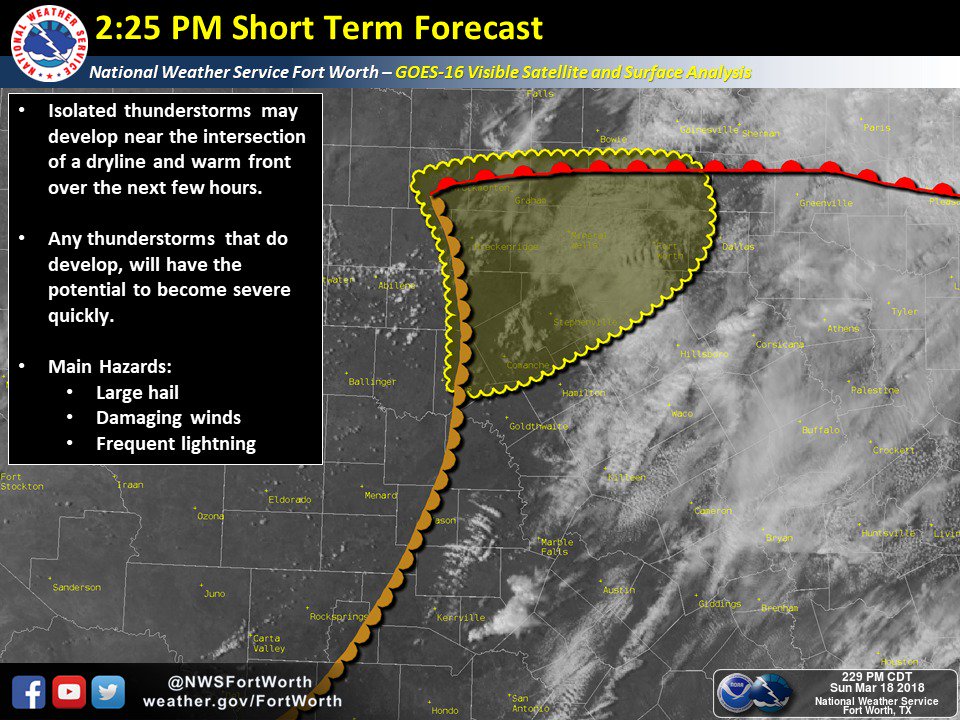
ETA: 1st serious attempt failed as it moved north towards the Red River. It looks like a few cells are trying to fire in the open warm sector, that might be an indication that the CAP has given up.

ETA: 1st serious attempt failed as it moved north towards the Red River. It looks like a few cells are trying to fire in the open warm sector, that might be an indication that the CAP has given up.
Last edited by bubba hotep on Sun Mar 18, 2018 3:43 pm, edited 1 time in total.
0 likes
Winter time post are almost exclusively focused on the DFW area.
-
1900hurricane

- Category 5
- Posts: 6063
- Age: 34
- Joined: Fri Feb 06, 2015 12:04 pm
- Location: Houston, TX
- Contact:
Re: Texas Spring 2018
Haris wrote:Uhhhh 12z Euro anyone ???
Just a typical panhandle snowstorm and massive rain event for the entire state with cape near 3000 and severe weather
It's getting to be that time of year. The big closed low near the NEUS is a big red flag for moisture quality if the run is taken at face value (especially for an early season event), but there is plenty of time for things to shake out as any possible event moves closer from the medium range.
0 likes
Contract Meteorologist. TAMU & MSST. Fiercely authentic, one of a kind. We are all given free will, so choose a life meant to be lived. We are the Masters of our own Stories.
Opinions expressed are mine alone.
Follow me on Twitter at @1900hurricane : Read blogs at https://1900hurricane.wordpress.com/
Opinions expressed are mine alone.
Follow me on Twitter at @1900hurricane : Read blogs at https://1900hurricane.wordpress.com/

Re: Texas Spring 2018
I’m 25,000 feet up about 60 miles NE of Dallas. Atmosphere looks and feels pretty stable from this vantage point. We are flying to Midland and were thinking about landing in Abilene due to possibly having 50-65 mph wind in Midland (probably from air being sucked into the storms). The pilots just told us they are not as worried about the high wind forecast anymore, so maybe that’s another sign forecasters are backing off storm development. I hope for my stomach’s sake they are correct!
0 likes
-
bubba hotep
- S2K Supporter
- Posts: 6014
- Joined: Wed Dec 28, 2016 1:00 am
- Location: Collin County Texas
Re: Texas Spring 2018
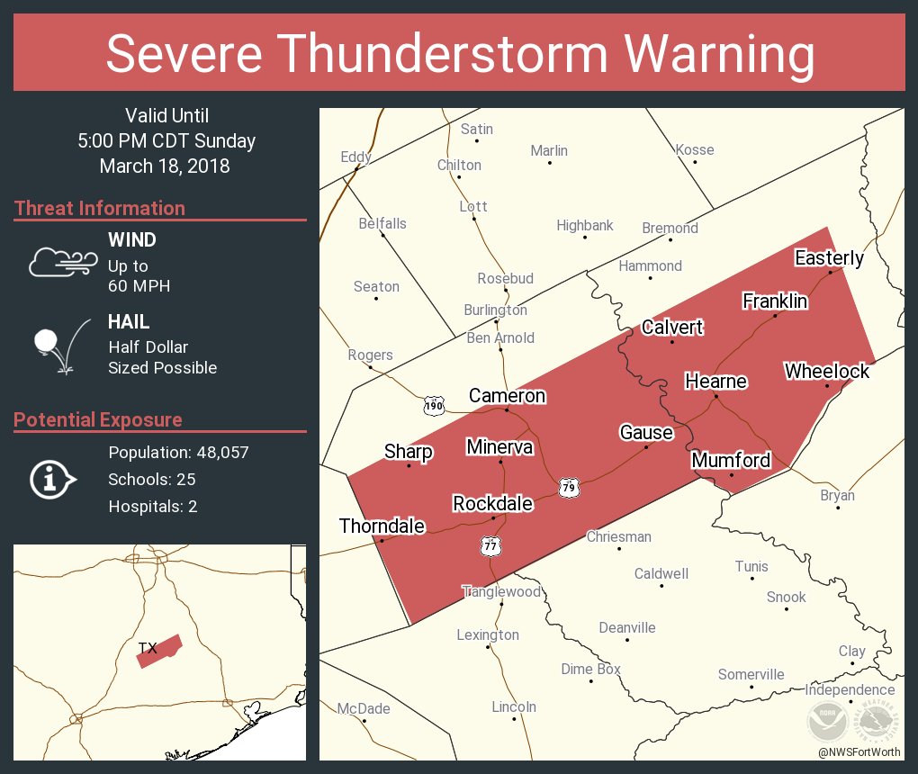
1st warning is well south of DFW
0 likes
Winter time post are almost exclusively focused on the DFW area.
-
bubba hotep
- S2K Supporter
- Posts: 6014
- Joined: Wed Dec 28, 2016 1:00 am
- Location: Collin County Texas
Re: Texas Spring 2018
Pretty big watch covering much of Central & East Texas
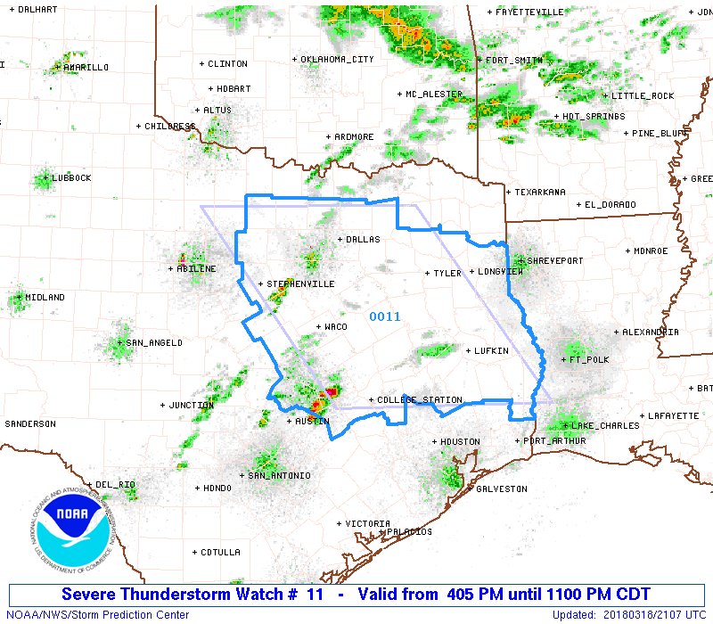
URGENT - IMMEDIATE BROADCAST REQUESTED
Severe Thunderstorm Watch Number 11
NWS Storm Prediction Center Norman OK
405 PM CDT Sun Mar 18 2018
The NWS Storm Prediction Center has issued a
* Severe Thunderstorm Watch for portions of
North-central and East Texas
* Effective this Sunday afternoon and evening from 405 PM until
1100 PM CDT.
* Primary threats include...
Scattered large hail and isolated very large hail events to 3
inches in diameter possible
Isolated damaging wind gusts to 70 mph possible
A tornado or two possible
SUMMARY...At least isolated severe storms are expected to increase
initially across central Texas in the general vicinity of Interstate
35 this afternoon, and subsequently spread eastward toward East
Texas by evening. Large hail should be the most common hazard, but
locally damaging winds and/or a tornado cannot be ruled out,
particularly as low-level shear increases this evening.
The severe thunderstorm watch area is approximately along and 105
statute miles east and west of a line from 35 miles north of Fort
Worth TX to 25 miles southeast of Huntsville TX. For a complete
depiction of the watch see the associated watch outline update
(WOUS64 KWNS WOU1).
PRECAUTIONARY/PREPAREDNESS ACTIONS...
REMEMBER...A Severe Thunderstorm Watch means conditions are
favorable for severe thunderstorms in and close to the watch area.
Persons in these areas should be on the lookout for threatening
weather conditions and listen for later statements and possible
warnings. Severe thunderstorms can and occasionally do produce
tornadoes.
&&
AVIATION...A few severe thunderstorms with hail surface and aloft to
3 inches. Extreme turbulence and surface wind gusts to 60 knots. A
few cumulonimbi with maximum tops to 500. Mean storm motion vector
26025.
...Guyer
0 likes
Winter time post are almost exclusively focused on the DFW area.
-
1900hurricane
- Category 5
- Posts: 6063
- Age: 34
- Joined: Fri Feb 06, 2015 12:04 pm
- Location: Houston, TX
- Contact:
Re: Texas Spring 2018
Based on the next couple of radar frames, I might have to shove the food I just made into the fridge so I can make the short jaunt north.
2 likes
Contract Meteorologist. TAMU & MSST. Fiercely authentic, one of a kind. We are all given free will, so choose a life meant to be lived. We are the Masters of our own Stories.
Opinions expressed are mine alone.
Follow me on Twitter at @1900hurricane : Read blogs at https://1900hurricane.wordpress.com/
Opinions expressed are mine alone.
Follow me on Twitter at @1900hurricane : Read blogs at https://1900hurricane.wordpress.com/
-
bubba hotep
- S2K Supporter
- Posts: 6014
- Joined: Wed Dec 28, 2016 1:00 am
- Location: Collin County Texas
Re: Texas Spring 2018
1900hurricane wrote:Based on the next couple of radar frames, I might have to shove the food I just made into the fridge so I can make the short jaunt north.
That cell is beasting
0 likes
Winter time post are almost exclusively focused on the DFW area.
-
Brent
- S2K Supporter
- Posts: 38739
- Age: 37
- Joined: Sun May 16, 2004 10:30 pm
- Location: Tulsa Oklahoma
- Contact:
Re: Texas Spring 2018
Wonder if those storms SW of Cleburne will make it into the metroplex
0 likes
#neversummer
-
rwfromkansas
- Category 5
- Posts: 3032
- Joined: Sat Aug 27, 2005 12:47 am
- Location: North Fort Worth
Re: Texas Spring 2018
Looks like the NWS is going to have a major bust. All the storms look to miss DFW to the south...not the north. It is still early though.
0 likes
-
bubba hotep
- S2K Supporter
- Posts: 6014
- Joined: Wed Dec 28, 2016 1:00 am
- Location: Collin County Texas
Re: Texas Spring 2018
Brent wrote:Wonder if those storms SW of Cleburne will make it into the metroplex
Looks like a cell trying to fire near the airport. Also, the CU is getting very agitated out in the western portions of the watch area due west of DFW. That would be the area to watch as the dryline bulges.
0 likes
Winter time post are almost exclusively focused on the DFW area.
-
bubba hotep
- S2K Supporter
- Posts: 6014
- Joined: Wed Dec 28, 2016 1:00 am
- Location: Collin County Texas
-
cheezyWXguy

- Category 5
- Posts: 6282
- Joined: Mon Feb 13, 2006 12:29 am
- Location: Dallas, TX
Re: Texas Spring 2018
1900hurricane wrote:Based on the next couple of radar frames, I might have to shove the food I just made into the fridge so I can make the short jaunt north.
I would take the southern storm of the two, near Caldwell. Looks much more intense than the one nw of college station
0 likes
-
bubba hotep
- S2K Supporter
- Posts: 6014
- Joined: Wed Dec 28, 2016 1:00 am
- Location: Collin County Texas
Re: Texas Spring 2018
bubba hotep wrote:Brent wrote:Wonder if those storms SW of Cleburne will make it into the metroplex
Looks like a cell trying to fire near the airport. Also, the CU is getting very agitated out in the western portions of the watch area due west of DFW. That would be the area to watch as the dryline bulges.
Cell near the airport died out quickly and now it looks like the cells south of DFW will probably be the farthest north that we will see today.
0 likes
Winter time post are almost exclusively focused on the DFW area.
-
bubba hotep
- S2K Supporter
- Posts: 6014
- Joined: Wed Dec 28, 2016 1:00 am
- Location: Collin County Texas

Return to “USA & Caribbean Weather”
Who is online
Users browsing this forum: Cpv17 and 23 guests