


2018 Indicators: SST's / MSLP / Sal / Steering / Shear / Instability (Graphic updates at first post)
Moderator: S2k Moderators
Forum rules

The posts in this forum are NOT official forecasts and should not be used as such. They are just the opinion of the poster and may or may not be backed by sound meteorological data. They are NOT endorsed by any professional institution or STORM2K. For official information, please refer to products from the National Hurricane Center and National Weather Service.
-
NotSparta

- Professional-Met

- Posts: 1677
- Age: 24
- Joined: Fri Aug 18, 2017 8:24 am
- Location: Naples, FL
- Contact:
Re: 2018 Indicators: SST's / MSLP / Sal / Steering / Shear / Instability (Graphic updates at first post)
StruThiO wrote:
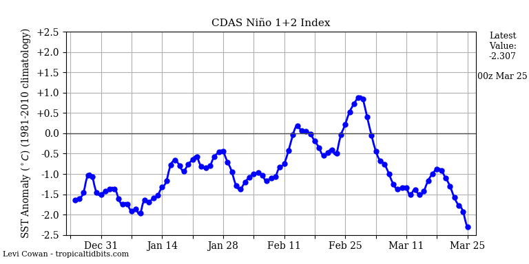
Niño 1+2 is dropping like a rock.
1 likes
This post was probably an opinion of mine, and in no way is official. Please refer to http://www.hurricanes.gov for official tropical analysis and advisories.
My website, with lots of tropical wx graphics, including satellite and recon: http://cyclonicwx.com
My website, with lots of tropical wx graphics, including satellite and recon: http://cyclonicwx.com
-
NotSparta
- Professional-Met
- Posts: 1677
- Age: 24
- Joined: Fri Aug 18, 2017 8:24 am
- Location: Naples, FL
- Contact:
Re: 2018 Indicators: SST's / MSLP / Sal / Steering / Shear / Instability (Graphic updates at first post)
Nearly textbook -AMO look imo
1 likes
This post was probably an opinion of mine, and in no way is official. Please refer to http://www.hurricanes.gov for official tropical analysis and advisories.
My website, with lots of tropical wx graphics, including satellite and recon: http://cyclonicwx.com
My website, with lots of tropical wx graphics, including satellite and recon: http://cyclonicwx.com
-
cycloneye

- Admin

- Posts: 149736
- Age: 69
- Joined: Thu Oct 10, 2002 10:54 am
- Location: San Juan, Puerto Rico
Re: 2018 Indicators: SST's / MSLP / Sal / Steering / Shear / Instability (Graphic updates at first post)
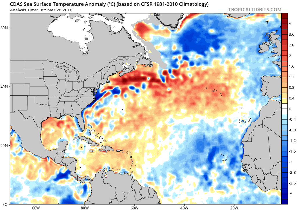
The continous surges of Saharan Air Layer plumes are causing the sst's to cool in MDR. Let's see how this continues as ASO gets closer.Interesting what Michael Ventrice says about predicting these SAL outbreaks.
@MJVentrice
Check out this Saharan Air Layer, which is composed of dry Saharan dust, get advected off West Africa in an apparent trade surge over the eastern tropical Atlantic into Africa.
https://twitter.com/MJVentrice/status/978691201334435840


@MJVentrice
This suggests that there is predictability in forecasting large Saharan Air Layer Outbreaks over the tropical Atlantic on the order of weeks in advance.
@MJVentrice
The general thought train here is that the enhanced trades associated with the circulation of the Kelvin wave (in this case, collocated with the suppressed phase of the Kelvin wave) will propagate eastward across Africa, kicking off a Saharan Air Layer Outbreak
https://twitter.com/MJVentrice/status/978692814677606402
@MJVentrice
Note that the Saharan Air Layer Outbreak is timed with the passage of the convectively suppressed phase of a strong atmospheric Kelvin wave across Africa
https://twitter.com/MJVentrice/status/978691375075033088
@EricBlake12
The trick is the collocation with the MJO to me- negative phase of that is more likely to enhance Subtropical ridge and cause the trades. The CCKW probably just provides the peak strength. Would be an interesting study
https://twitter.com/EricBlake12/status/978693567899107328
@MJVentrice
Check out this Saharan Air Layer, which is composed of dry Saharan dust, get advected off West Africa in an apparent trade surge over the eastern tropical Atlantic into Africa.
https://twitter.com/MJVentrice/status/978691201334435840
@MJVentrice
This suggests that there is predictability in forecasting large Saharan Air Layer Outbreaks over the tropical Atlantic on the order of weeks in advance.
@MJVentrice
The general thought train here is that the enhanced trades associated with the circulation of the Kelvin wave (in this case, collocated with the suppressed phase of the Kelvin wave) will propagate eastward across Africa, kicking off a Saharan Air Layer Outbreak
https://twitter.com/MJVentrice/status/978692814677606402
@MJVentrice
Note that the Saharan Air Layer Outbreak is timed with the passage of the convectively suppressed phase of a strong atmospheric Kelvin wave across Africa
https://twitter.com/MJVentrice/status/978691375075033088
@EricBlake12
The trick is the collocation with the MJO to me- negative phase of that is more likely to enhance Subtropical ridge and cause the trades. The CCKW probably just provides the peak strength. Would be an interesting study
https://twitter.com/EricBlake12/status/978693567899107328
2 likes
Visit the Caribbean-Central America Weather Thread where you can find at first post web cams,radars
and observations from Caribbean basin members Click Here
and observations from Caribbean basin members Click Here
-
cycloneye
- Admin
- Posts: 149736
- Age: 69
- Joined: Thu Oct 10, 2002 10:54 am
- Location: San Juan, Puerto Rico
Re: 2018 Indicators: SST's / MSLP / Sal / Steering / Shear / Instability (Graphic updates at first post)
A biggie outbreak of SAL.Hopefully,these outbreaks continue thru the peak months of the season and MDR is quiet.You know why I am rooting for a quiet season. We need +NAO.

1 likes
Visit the Caribbean-Central America Weather Thread where you can find at first post web cams,radars
and observations from Caribbean basin members Click Here
and observations from Caribbean basin members Click Here
-
NotSparta
- Professional-Met
- Posts: 1677
- Age: 24
- Joined: Fri Aug 18, 2017 8:24 am
- Location: Naples, FL
- Contact:
Re: 2018 Indicators: SST's / MSLP / Sal / Steering / Shear / Instability (Graphic updates at first post)
cycloneye wrote:A biggie outbreak of SAL.Hopefully,these outbreaks continue thru the peak months of the season and MDR is quiet.You know why I am rooting for a quiet season. We need +NAO.
[img ]https://i.imgur.com/neQHCSQ.jpg[/img]
The SAL outbreaks themselves are cooling the MDR right now, if the -NAO continues I'm hoping for the outbreaks to continue, and later it would suppress tropical waves
1 likes
This post was probably an opinion of mine, and in no way is official. Please refer to http://www.hurricanes.gov for official tropical analysis and advisories.
My website, with lots of tropical wx graphics, including satellite and recon: http://cyclonicwx.com
My website, with lots of tropical wx graphics, including satellite and recon: http://cyclonicwx.com
-
NotSparta
- Professional-Met
- Posts: 1677
- Age: 24
- Joined: Fri Aug 18, 2017 8:24 am
- Location: Naples, FL
- Contact:
Re: 2018 Indicators: SST's / MSLP / Sal / Steering / Shear / Instability (Graphic updates at first post)
StruThiO wrote:[tweet ]https://twitter.com/philklotzbach/status/981609871056539649[/tweet]
Has probably gone down in the recent days, it may fall for April 2018 if the SST anomaly pattern sticks
0 likes
This post was probably an opinion of mine, and in no way is official. Please refer to http://www.hurricanes.gov for official tropical analysis and advisories.
My website, with lots of tropical wx graphics, including satellite and recon: http://cyclonicwx.com
My website, with lots of tropical wx graphics, including satellite and recon: http://cyclonicwx.com
-
Shell Mound
- Category 5

- Posts: 2432
- Age: 33
- Joined: Thu Sep 07, 2017 3:39 pm
- Location: St. Petersburg, FL → Scandinavia
Re: 2018 Indicators: SST's / MSLP / Sal / Steering / Shear / Instability (Graphic updates at first post)
Interestingly, the March '18 reading was the most positive since March '13. March '17's reading was -0.61 standard deviations vs. this year's -0.5. So the AMO, overall, remains in the most positive state we have seen in several years, despite fluctuations. We will need to see if the April reading is more positive than April '17's (which was at -0.81 standard deviations). If the upcoming April reading is fairly close, then the AMO thus far in 2018 will be roughly on par with 2017's.
https://tropical.colostate.edu/colorado-state-university-amo/
2 likes
CVW / MiamiensisWx / Shell Mound
The posts in this forum are NOT official forecasts and should not be used as such. They are just the opinion of the poster and may or may not be backed by sound meteorological data. They are NOT endorsed by any professional institution or STORM2K. For official information, please refer to products from the NHC and NWS.
-
cycloneye
- Admin
- Posts: 149736
- Age: 69
- Joined: Thu Oct 10, 2002 10:54 am
- Location: San Juan, Puerto Rico
Re: 2018 Indicators: SST's / MSLP / Sal / Steering / Shear / Instability (Graphic updates at first post)
@webberweather
The warming MDR last yr late in the spring & summer likely hastened the demise of the failed NINO attempt. If the tropical Atlantic fails to warm this time around, +ENSO and NINO is probably more likely to couple w/ the -AMO SST configuration ongoing atm. https://agupubs.onlinelibrary.wiley.com ... 15GL064381 …
https://twitter.com/webberweather/status/981931171876663297
2 likes
Visit the Caribbean-Central America Weather Thread where you can find at first post web cams,radars
and observations from Caribbean basin members Click Here
and observations from Caribbean basin members Click Here
-
NotSparta
- Professional-Met
- Posts: 1677
- Age: 24
- Joined: Fri Aug 18, 2017 8:24 am
- Location: Naples, FL
- Contact:
Re: 2018 Indicators: SST's / MSLP / Sal / Steering / Shear / Instability (Graphic updates at first post)
cycloneye wrote:@webberweather
The warming MDR last yr late in the spring & summer likely hastened the demise of the failed NINO attempt. If the tropical Atlantic fails to warm this time around, +ENSO and NINO is probably more likely to couple w/ the -AMO SST configuration ongoing atm. https://agupubs.onlinelibrary.wiley.com ... 15GL064381 …
https://twitter.com/webberweather/status/981931171876663297
So they seem related, I'll be checking zonal wind anoms for both ENSO and MDR regions
0 likes
This post was probably an opinion of mine, and in no way is official. Please refer to http://www.hurricanes.gov for official tropical analysis and advisories.
My website, with lots of tropical wx graphics, including satellite and recon: http://cyclonicwx.com
My website, with lots of tropical wx graphics, including satellite and recon: http://cyclonicwx.com
-
Shell Mound
- Category 5
- Posts: 2432
- Age: 33
- Joined: Thu Sep 07, 2017 3:39 pm
- Location: St. Petersburg, FL → Scandinavia
Re: 2018 Indicators: SST's / MSLP / Sal / Steering / Shear / Instability (Graphic updates at first post)
cycloneye wrote:@webberweather
The warming MDR last yr late in the spring & summer likely hastened the demise of the failed NINO attempt. If the tropical Atlantic fails to warm this time around, +ENSO and NINO is probably more likely to couple w/ the -AMO SST configuration ongoing atm. https://agupubs.onlinelibrary.wiley.com ... 15GL064381 …
https://twitter.com/webberweather/status/981931171876663297
https://twitter.com/webberweather/status/981914703239794689
https://twitter.com/AndyHazelton/status/981916392634109952
https://twitter.com/webberweather/status/981918123627634688
https://twitter.com/webberweather/status/981930439320449024
This evidence, including past history, seems to strongly support the idea of an inactive season in 2018. At least that's what I see. Warm East Pacific (+Pacific Meridional Mode/PMM) north of the equator + cooler MDR vs. spring '17 + cool Indian Ocean + generally +PDO = enhanced upward (downward) motion over East Pacific (Atlantic), meaning lower (higher) sea-level pressures over EPAC (tropical Atlantic), enhanced (suppressed) TC formation in EPAC (tropical Atlantic/Caribbean), decreased (increased) vertical shear over EPAC (tropical Atlantic/Caribbean), and favourable background feedback -> -SOI, MJO, and WWB to further growth of El Niño by peak of Atlantic hurricane season. It's all connected. A very warm MDR (warmer than this year's) and La Niña did not overcome +PMM and +PDO in 1978, 1980, 1981, and 1988, which were all inactive over the Atlantic basin, which seems to put a monkey wrench into theories that put a lot of weight on MDR SST anomalies.
0 likes
CVW / MiamiensisWx / Shell Mound
The posts in this forum are NOT official forecasts and should not be used as such. They are just the opinion of the poster and may or may not be backed by sound meteorological data. They are NOT endorsed by any professional institution or STORM2K. For official information, please refer to products from the NHC and NWS.
-
Digital-TC-Chaser
Re: 2018 Indicators: SST's / MSLP / Sal / Steering / Shear / Instability (Graphic updates at first post)
Humm CSU forecast not buying into a inactive season atm. Seems the old season is likely
over before it has begun campaigns is raring its head again.
https://www.wunderground.com/cat6/csu-2 ... ve-average
over before it has begun campaigns is raring its head again.
https://www.wunderground.com/cat6/csu-2 ... ve-average
1 likes
-
CyclonicFury

- Category 5
- Posts: 2038
- Age: 27
- Joined: Sun Jul 02, 2017 12:32 pm
- Location: NC
- Contact:
Re: 2018 Indicators: SST's / MSLP / Sal / Steering / Shear / Instability (Graphic updates at first post)
CFS shows a significant slowing of trade winds over the MDR later this month. If this verifies, the MDR may warm up quite a bit before the start of the season...

1 likes
NCSU B.S. in Meteorology Class of 2021. Tropical weather blogger at http://www.cyclonicfury.com. My forecasts and thoughts are NOT official, for official forecasts please consult the National Hurricane Center.
-
NotSparta
- Professional-Met
- Posts: 1677
- Age: 24
- Joined: Fri Aug 18, 2017 8:24 am
- Location: Naples, FL
- Contact:
Re: 2018 Indicators: SST's / MSLP / Sal / Steering / Shear / Instability (Graphic updates at first post)
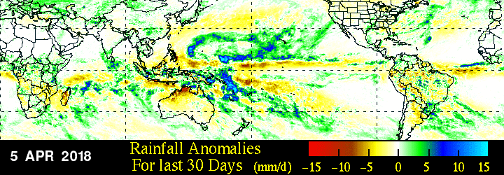
It appears here that there has been less rain than normal in most of the ATL ITCZ area, but much above normal a bit to the north. It seems this is a signal of the ITCZ there being slightly further north than usual for this time of year, if I am correct.
0 likes
This post was probably an opinion of mine, and in no way is official. Please refer to http://www.hurricanes.gov for official tropical analysis and advisories.
My website, with lots of tropical wx graphics, including satellite and recon: http://cyclonicwx.com
My website, with lots of tropical wx graphics, including satellite and recon: http://cyclonicwx.com
-
cycloneye
- Admin
- Posts: 149736
- Age: 69
- Joined: Thu Oct 10, 2002 10:54 am
- Location: San Juan, Puerto Rico
Re: 2018 Indicators: SST's / MSLP / Sal / Steering / Shear / Instability (Graphic updates at first post)
@webberweather
Something to keep in mind this hurricane season. You don't need an El Nino to increase shear in the MDR & make conditions hostile for TCG. Years like this w/ a +PMM & active EP actually have above avg shear & less TC activity in the MDR despite there not being an El Nino on paper
https://twitter.com/webberweather/status/982296766098956290
1 likes
Visit the Caribbean-Central America Weather Thread where you can find at first post web cams,radars
and observations from Caribbean basin members Click Here
and observations from Caribbean basin members Click Here
-
Shell Mound
- Category 5
- Posts: 2432
- Age: 33
- Joined: Thu Sep 07, 2017 3:39 pm
- Location: St. Petersburg, FL → Scandinavia
Re: 2018 Indicators: SST's / MSLP / Sal / Steering / Shear / Instability (Graphic updates at first post)
https://twitter.com/webberweather/status/982267694031355905
https://twitter.com/webberweather/status/982314817657729024
https://twitter.com/webberweather/status/982315699828871173
https://twitter.com/MJVentrice/status/982292469013364736
https://twitter.com/webberweather/status/982331086498947073
https://twitter.com/webberweather/status/982351406915973120
https://twitter.com/webberweather/status/982314817657729024
https://twitter.com/webberweather/status/982315699828871173
https://twitter.com/MJVentrice/status/982292469013364736
https://twitter.com/webberweather/status/982331086498947073
https://twitter.com/webberweather/status/982351406915973120
0 likes
CVW / MiamiensisWx / Shell Mound
The posts in this forum are NOT official forecasts and should not be used as such. They are just the opinion of the poster and may or may not be backed by sound meteorological data. They are NOT endorsed by any professional institution or STORM2K. For official information, please refer to products from the NHC and NWS.
-
NotSparta
- Professional-Met
- Posts: 1677
- Age: 24
- Joined: Fri Aug 18, 2017 8:24 am
- Location: Naples, FL
- Contact:
Re: 2018 Indicators: SST's / MSLP / Sal / Steering / Shear / Instability (Graphic updates at first post)
Shell Mound wrote:--quote removed-
One of those is not like the other
0 likes
This post was probably an opinion of mine, and in no way is official. Please refer to http://www.hurricanes.gov for official tropical analysis and advisories.
My website, with lots of tropical wx graphics, including satellite and recon: http://cyclonicwx.com
My website, with lots of tropical wx graphics, including satellite and recon: http://cyclonicwx.com
-
tolakram
- Admin
- Posts: 20186
- Age: 62
- Joined: Sun Aug 27, 2006 8:23 pm
- Location: Florence, KY (name is Mark)
Re: 2018 Indicators: SST's / MSLP / Sal / Steering / Shear / Instability (Graphic updates at first post)
Folks are documenting what people are saying here in the great unknown period prior to, say, mid May. In my opinion anyway, this is a good thing.
Also, please avoid quoting an entire long message just to add a small comment. Thanks.
Also, please avoid quoting an entire long message just to add a small comment.
3 likes
M a r k
- - - - -
Join us in chat: Storm2K Chatroom Invite. Android and IOS apps also available.
The posts in this forum are NOT official forecasts and should not be used as such. Posts are NOT endorsed by any professional institution or STORM2K.org. For official information and forecasts, please refer to NHC and NWS products.
Who is online
Users browsing this forum: No registered users and 175 guests