Texas Spring 2018

U.S. & Caribbean Weather Discussions and Severe Weather Events

Moderator: S2k Moderators

Forum rules

The posts in this forum are NOT official forecast and should not be used as such. They are just the opinion of the poster and may or may not be backed by sound meteorological data. They are NOT endorsed by any professional institution or STORM2K.

Help Support Storm2K
Message
Author
weatherdude1108
Category 5
Category 5
Posts: 4228
Joined: Tue Dec 13, 2011 1:04 pm
Location: Northwest Austin/Cedar Park, TX

Re: Texas Spring 2018

#941 Postby weatherdude1108 » Mon Apr 30, 2018 3:43 pm

JDawg512 wrote:At this point, I'll be happy with 1-2 inches. Too much too quickly won't do a ton of good.


Me too. 1-3 inches over a week is a nice soaking in the upper soils. It would keep the deeper soils damp to moist.
2 likes   
The preceding post is NOT an official forecast, and should not be used as such. It is only the opinion of the poster and may or may not be backed by sound meteorological data. It is NOT endorsed by any professional institution including storm2k.org. For Official Information please refer to the NHC and NWS products.

User avatar
Haris
Category 5
Category 5
Posts: 1810
Joined: Mon Nov 27, 2017 8:19 pm
Location: ( Bee Cave) West Austin, Texas

Re: Texas Spring 2018

#942 Postby Haris » Mon Apr 30, 2018 5:16 pm

Image

:)
2 likes   
Weather geek and a storm spotter in West Austin. Not a degreed meteorologist. Big snow fan. Love rain and cold! Despise heat!

User avatar
Haris
Category 5
Category 5
Posts: 1810
Joined: Mon Nov 27, 2017 8:19 pm
Location: ( Bee Cave) West Austin, Texas

Re: Texas Spring 2018

#943 Postby Haris » Mon Apr 30, 2018 8:31 pm

Cold front should stall over the Austin metro Fri night. As long as we have that 2nd piece of energy, albeit weak, training heavy rains with PWATS near 2" likely like the gfs shows. My rain forecast prelim is 1-2" but could go higher if this trend continues/consistency
2 likes   
Weather geek and a storm spotter in West Austin. Not a degreed meteorologist. Big snow fan. Love rain and cold! Despise heat!

User avatar
Cpv17
Category 5
Category 5
Posts: 4976
Joined: Wed Dec 07, 2016 2:24 pm
Location: Wharton/El Campo, TX

Re: Texas Spring 2018

#944 Postby Cpv17 » Mon Apr 30, 2018 8:37 pm

Haris wrote:http://i66.tinypic.com/2rojogn.png

:)

Man that’s a nice soaking from SA up to the ATX. It looks like the axis for heavier rains has shifted a bit east today.
2 likes   

User avatar
Haris
Category 5
Category 5
Posts: 1810
Joined: Mon Nov 27, 2017 8:19 pm
Location: ( Bee Cave) West Austin, Texas

Re: Texas Spring 2018

#945 Postby Haris » Mon Apr 30, 2018 8:49 pm

Cpv17 wrote:
Haris wrote:http://i66.tinypic.com/2rojogn.png

:)

Man that’s a nice soaking from SA up to the ATX. It looks like the axis for heavier rains has shifted a bit east today.


Thing is, I dont prefer being in the "bulls eye" 4 days out or so. Hopefully they dont ditch it ;)
1 likes   
Weather geek and a storm spotter in West Austin. Not a degreed meteorologist. Big snow fan. Love rain and cold! Despise heat!

User avatar
bubba hotep
S2K Supporter
S2K Supporter
Posts: 5837
Joined: Wed Dec 28, 2016 1:00 am
Location: Collin County Texas

Re: Texas Spring 2018

#946 Postby bubba hotep » Mon Apr 30, 2018 9:51 pm

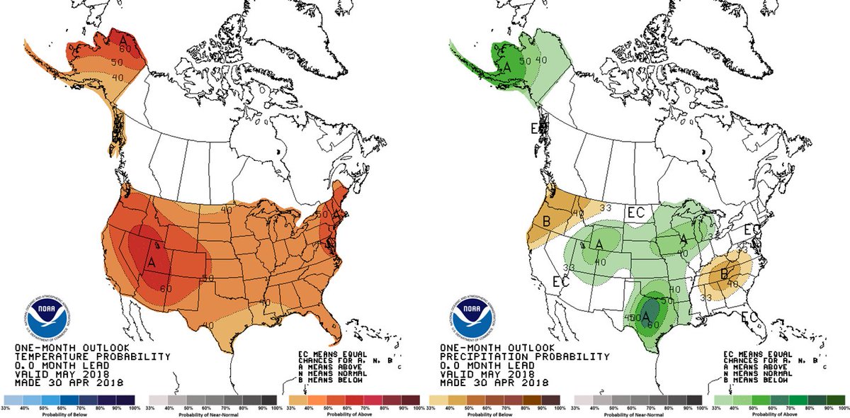
Final May Outlook

Image
4 likes   
Winter time post are almost exclusively focused on the DFW area.

User avatar
Haris
Category 5
Category 5
Posts: 1810
Joined: Mon Nov 27, 2017 8:19 pm
Location: ( Bee Cave) West Austin, Texas

Re: Texas Spring 2018

#947 Postby Haris » Mon Apr 30, 2018 9:58 pm

bubba hotep wrote:Final May Outlook

https://pbs.twimg.com/media/DcDcWIXWkAMtfiN.jpg


I dont disagree. Much of W-Central TX will be pick up 2-4" of rain later this week and it will rain again this month, so its bound to be above normal. Wonder if we get 2015 again ?? lol
1 likes   
Weather geek and a storm spotter in West Austin. Not a degreed meteorologist. Big snow fan. Love rain and cold! Despise heat!

User avatar
Cpv17
Category 5
Category 5
Posts: 4976
Joined: Wed Dec 07, 2016 2:24 pm
Location: Wharton/El Campo, TX

Re: Texas Spring 2018

#948 Postby Cpv17 » Mon Apr 30, 2018 10:42 pm

bubba hotep wrote:Final May Outlook

https://pbs.twimg.com/media/DcDcWIXWkAMtfiN.jpg


Even though I’m not in the darker green colors, if that verifies I won’t complain one bit.
1 likes   

User avatar
Haris
Category 5
Category 5
Posts: 1810
Joined: Mon Nov 27, 2017 8:19 pm
Location: ( Bee Cave) West Austin, Texas

Re: Texas Spring 2018

#949 Postby Haris » Tue May 01, 2018 8:22 am

Still looks like a 1-3” soaking for Central TX. Could get unsettled again late next week . Let the May come
0 likes   
Weather geek and a storm spotter in West Austin. Not a degreed meteorologist. Big snow fan. Love rain and cold! Despise heat!

User avatar
Haris
Category 5
Category 5
Posts: 1810
Joined: Mon Nov 27, 2017 8:19 pm
Location: ( Bee Cave) West Austin, Texas

Re: Texas Spring 2018

#950 Postby Haris » Tue May 01, 2018 11:45 am

Image

:)
2 likes   
Weather geek and a storm spotter in West Austin. Not a degreed meteorologist. Big snow fan. Love rain and cold! Despise heat!

weatherdude1108
Category 5
Category 5
Posts: 4228
Joined: Tue Dec 13, 2011 1:04 pm
Location: Northwest Austin/Cedar Park, TX

Re: Texas Spring 2018

#951 Postby weatherdude1108 » Tue May 01, 2018 3:41 pm

We need to enjoy whatever rain we get this week, because it looks like another dry spell is starting Saturday.

May is our wettest month of the year climatologically, or it should be.
:roll:

Area Forecast Discussion
National Weather Service Austin/San Antonio TX
238 PM CDT Tue May 1 2018

.SHORT TERM (Tonight through Wednesday Night)...
Capping will maintain a solid hold on vertical motion over South
Central Texas through late afternoon Wednesday. Return gulf flow and
weak upglide will maintain mostly cloudy skies and patchy drizzle and
fog...primarily from late evening through mid-morning...when the
low-level jet is strongest/active.

&&

.LONG TERM (Thursday through Tuesday)...
The upper level trough and associated cold front will be on the
doorstep of our area by Thursday morning...and be nearly stationary
or slowly progress east/south through Saturday morning. Capping will
limit convection...but there should be enough general ascent from the
front and trough to reach the LFC, especially over the Edwards
Plateau and Rio Grande Plains...where there is a slight risk of
severe storms. The main severe threat will be large hail, with a
secondary threat of damaging winds.

The close proximity of the front and trough, plus confluent flow in
the low and mid levels, will lead to a moist adiabatic profile and
heavy rain threat Thursday night into Friday night. Average rainfall
amounts will range from 1 to 2 inches, but a few spots may receive
up to 4 inches of rain for the three-day event.


The front will push south of the area on Saturday, bringing an end to
rain by midday. Persistent zonal flow from Sunday through most of
next week will bring mostly sunny skies, dry conditions, and near
normal temperatures
.


Image
Image
Last edited by weatherdude1108 on Tue May 01, 2018 3:45 pm, edited 1 time in total.
0 likes   
The preceding post is NOT an official forecast, and should not be used as such. It is only the opinion of the poster and may or may not be backed by sound meteorological data. It is NOT endorsed by any professional institution including storm2k.org. For Official Information please refer to the NHC and NWS products.

User avatar
JDawg512
Category 5
Category 5
Posts: 1076
Age: 45
Joined: Mon Aug 26, 2013 8:56 pm
Location: Austin
Contact:

Re: Texas Spring 2018

#952 Postby JDawg512 » Tue May 01, 2018 3:42 pm

18.84in of rain fell here at the Rain Cave in 2015, as much as I love rain, that was a bit much even for my wet standards. Unfortunately I'm getting pretty grumpy about the extended forecast. I hope a wetter than average May occures, however once this rain event is over, next week is back to quiet dry weather. The cap continues and as of this afternoon the NWS is lessening the severe threat which isn't a bad thing as long as we get the rain amounts. The issue is that the cap has been very difficult to erode this year which is inhibiting rainfall. Until the cap weakens or becomes non existent, more of the same is likely with extended dry periods with a decent rain event in between.
0 likes   
Resident Rain Miser

I am a weather hobbyist living 3.5 miles south of Downtown Austin and in no way or fashion should anything I say concerning forecasts be taken seriously. Please check your local NWS for accurate weather forecasting and conditions.

User avatar
Cpv17
Category 5
Category 5
Posts: 4976
Joined: Wed Dec 07, 2016 2:24 pm
Location: Wharton/El Campo, TX

Re: Texas Spring 2018

#953 Postby Cpv17 » Tue May 01, 2018 3:49 pm

JDawg512 wrote:18.84in of rain fell here at the Rain Cave in 2015, as much as I love rain, that was a bit much even for my wet standards. Unfortunately I'm getting pretty grumpy about the extended forecast. I hope a wetter than average May occures, however once this rain event is over, next week is back to quiet dry weather. The cap continues and as of this afternoon the NWS is lessening the severe threat which isn't a bad thing as long as we get the rain amounts. The issue is that the cap has been very difficult to erode this year which is inhibiting rainfall. Until the cap weakens or becomes non existent, more of the same is likely with extended dry periods with a decent rain event in between.


I think the cooler than average temps this spring have hurt the chances for severe weather along with the frequency of the fronts coming in limiting the amount of moisture and instability for storm systems to work with. Just my two cents.
1 likes   

User avatar
JDawg512
Category 5
Category 5
Posts: 1076
Age: 45
Joined: Mon Aug 26, 2013 8:56 pm
Location: Austin
Contact:

Re: Texas Spring 2018

#954 Postby JDawg512 » Tue May 01, 2018 4:00 pm

Cpv17 wrote:
JDawg512 wrote:18.84in of rain fell here at the Rain Cave in 2015, as much as I love rain, that was a bit much even for my wet standards. Unfortunately I'm getting pretty grumpy about the extended forecast. I hope a wetter than average May occures, however once this rain event is over, next week is back to quiet dry weather. The cap continues and as of this afternoon the NWS is lessening the severe threat which isn't a bad thing as long as we get the rain amounts. The issue is that the cap has been very difficult to erode this year which is inhibiting rainfall. Until the cap weakens or becomes non existent, more of the same is likely with extended dry periods with a decent rain event in between.


I think the cooler than average temps this spring have hurt the chances for severe weather along with the frequency of the fronts coming in limiting the amount of moisture and instability for storm systems to work with. Just my two cents.


You hit the head on the nail. That has been a major factor so far which has also kept the cap strong. Now that we are in the transitional phase, will see if we can keep more moisture around longer.
0 likes   
Resident Rain Miser

I am a weather hobbyist living 3.5 miles south of Downtown Austin and in no way or fashion should anything I say concerning forecasts be taken seriously. Please check your local NWS for accurate weather forecasting and conditions.

Yukon Cornelius
S2K Supporter
S2K Supporter
Posts: 1798
Age: 41
Joined: Thu Dec 20, 2012 9:23 pm
Location: Dean, TX/Westcliffe, CO

Re: Texas Spring 2018

#955 Postby Yukon Cornelius » Tue May 01, 2018 4:05 pm

It appears the Enhanced threat for Wednesday has moved further North.
0 likes   
#neversummer

User avatar
bubba hotep
S2K Supporter
S2K Supporter
Posts: 5837
Joined: Wed Dec 28, 2016 1:00 am
Location: Collin County Texas

Re: Texas Spring 2018

#956 Postby bubba hotep » Tue May 01, 2018 5:05 pm

Models seem to be coming into pretty good agreement on an axis of heavy rain across DFW oriented from SW to NE. It looks like there will be too much CAP for any storms tomorrow afternoon and the main threat will be with a nocturnal MCS bringing straight line winds. However, as we all know, convective evolution can be tricky and things could change tomorrow.
0 likes   
Winter time post are almost exclusively focused on the DFW area.

User avatar
cheezyWXguy
Category 5
Category 5
Posts: 6108
Joined: Mon Feb 13, 2006 12:29 am
Location: Dallas, TX

Re: Texas Spring 2018

#957 Postby cheezyWXguy » Tue May 01, 2018 7:09 pm

bubba hotep wrote:Models seem to be coming into pretty good agreement on an axis of heavy rain across DFW oriented from SW to NE. It looks like there will be too much CAP for any storms tomorrow afternoon and the main threat will be with a nocturnal MCS bringing straight line winds. However, as we all know, convective evolution can be tricky and things could change tomorrow.

Looks more like midday Thursday. The nam has the line bisecting dfw at 17z (noon). If it slows down the timing any more, the severe threat will likely increase, as cape should be on the upswing around that time
0 likes   

rwfromkansas
Category 5
Category 5
Posts: 2627
Joined: Sat Aug 27, 2005 12:47 am
Location: North Fort Worth

Re: Texas Spring 2018

#958 Postby rwfromkansas » Wed May 02, 2018 8:27 am

Is the MCS why tomorrow is less of a severe day?
0 likes   

weatherdude1108
Category 5
Category 5
Posts: 4228
Joined: Tue Dec 13, 2011 1:04 pm
Location: Northwest Austin/Cedar Park, TX

Re: Texas Spring 2018

#959 Postby weatherdude1108 » Wed May 02, 2018 8:39 am

All I know is I'm tired of these intermittent drizzle/sprinkles we have gotten the past couple days. It occasionally "spits" out light rain showers for about 15 seconds, then back to occasional spitting drizzle/sprinkles.

Does nothing for the poor grass and vegetation. Mixes with the road oils causing slick streets that don't wash out, and spots up your car.lol It was 72 this morning at my house, with 92% humidity. Lots of moisture out there to feed whatever storms decide to fire, otherwise it's wasted moisture.
0 likes   
The preceding post is NOT an official forecast, and should not be used as such. It is only the opinion of the poster and may or may not be backed by sound meteorological data. It is NOT endorsed by any professional institution including storm2k.org. For Official Information please refer to the NHC and NWS products.

User avatar
Haris
Category 5
Category 5
Posts: 1810
Joined: Mon Nov 27, 2017 8:19 pm
Location: ( Bee Cave) West Austin, Texas

Re: Texas Spring 2018

#960 Postby Haris » Wed May 02, 2018 11:09 am

A hurricane type gradient will set up across the 35 corridor in Central TX! W of 35, 2-4” , E , 1 or less
0 likes   
Weather geek and a storm spotter in West Austin. Not a degreed meteorologist. Big snow fan. Love rain and cold! Despise heat!


Return to “USA & Caribbean Weather”

Who is online

Users browsing this forum: AnnularCane, Cpv17, JDawg512, txtwister78 and 7 guests