
Well before the week 2 wackiness, all of the global models are forming a weak BI (baroclinically initiated) low near Florida in about a week.
It forms in association with a cutoff 500MB low.
2018 Tropics: Global Model Runs Discussion (Out to day 16)
Moderator: S2k Moderators
Forum rules

The posts in this forum are NOT official forecasts and should not be used as such. They are just the opinion of the poster and may or may not be backed by sound meteorological data. They are NOT endorsed by any professional institution or STORM2K. For official information, please refer to products from the National Hurricane Center and National Weather Service.
-
cycloneye

- Admin

- Posts: 149334
- Age: 69
- Joined: Thu Oct 10, 2002 10:54 am
- Location: San Juan, Puerto Rico
Re: 2018 Tropics: Global Model Runs Discussion (Out to day 16)
@BigJoeBastardi
Was laughing before, not laughing any more at GFS longer term MJO forecasted through favorable phases, especially after day 10 ( phase 2) early activity next 10 days Pacific, then perhaps to Gulf, Caribbean or SW ATL day 10 on
https://twitter.com/BigJoeBastardi/status/993818201858469888
Was laughing before, not laughing any more at GFS longer term MJO forecasted through favorable phases, especially after day 10 ( phase 2) early activity next 10 days Pacific, then perhaps to Gulf, Caribbean or SW ATL day 10 on
https://twitter.com/BigJoeBastardi/status/993818201858469888
1 likes
Visit the Caribbean-Central America Weather Thread where you can find at first post web cams,radars
and observations from Caribbean basin members Click Here
and observations from Caribbean basin members Click Here
-
gatorcane

- S2K Supporter

- Posts: 23708
- Age: 48
- Joined: Sun Mar 13, 2005 3:54 pm
- Location: Boca Raton, FL
Re: 2018 Tropics: Global Model Runs Discussion (Out to day 16)
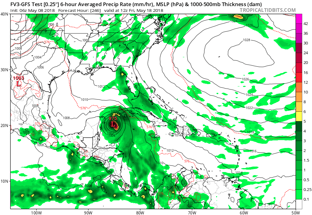
The new FIV3-GFS model is making this quite strong. The FIV3-GFS starts development in 1 week near Nicaragua and sends it north. Hard to believe something like this forms in May, looks more like October. Gets down to 975MB at 246 hours 
Last edited by gatorcane on Tue May 08, 2018 8:55 am, edited 1 time in total.
0 likes
-
TheStormExpert
Re: 2018 Tropics: Global Model Runs Discussion (Out to day 16)
You gotta be kidding me, right? The new-GFS shows a full-blown hurricane in the Gulf in a week and a half. Talk about an improvement from the current GFS. 

2 likes
-
gatorcane
- S2K Supporter
- Posts: 23708
- Age: 48
- Joined: Sun Mar 13, 2005 3:54 pm
- Location: Boca Raton, FL
Re: 2018 Tropics: Global Model Runs Discussion (Out to day 16)
AJC3 wrote:Well before the week 2 wackiness, all of the global models are forming a weak BI (baroclinically initiated) low near Florida in about a week.
It forms in association with a cutoff 500MB low.
Yeah looks interesting, that should be the catalyst to start the rainy season I would think, good news in that it would start early reducing the length of the "fire season." Looks like the ECMWF has it passing just east of Florida while the GFS is in the Eastern Gulf.
0 likes
-
WeatherEmperor
- S2K Supporter
- Posts: 4806
- Age: 42
- Joined: Thu Sep 04, 2003 2:54 pm
- Location: South Florida
Re: 2018 Tropics: Global Model Runs Discussion (Out to day 16)
gatorcane wrote:The new FIV3-GFS model is making this quite strong. The FIV3-GFS starts development in 1 week near Nicaragua and sends it north. Hard to believe something like this forms in May, looks more like October. Gets down to 975MB at 246 hours
[img]https://s18.postimg.cc/kz8xt17h5/fv3p_
I know it is very early in the season to be asking this question...but do you think this could be a major test for the FV3 implementation of the GFS? If this ends up being a phantom storm, then would it make the FV3 look very bad?
1 likes
-
NotSparta

- Professional-Met

- Posts: 1677
- Age: 24
- Joined: Fri Aug 18, 2017 8:24 am
- Location: Naples, FL
- Contact:
Re: 2018 Tropics: Global Model Runs Discussion (Out to day 16)
WeatherEmperor wrote:gatorcane wrote:The new FIV3-GFS model is making this quite strong. The FIV3-GFS starts development in 1 week near Nicaragua and sends it north. Hard to believe something like this forms in May, looks more like October. Gets down to 975MB at 246 hours
[img]https://s18.postimg.cc/kz8xt17h5/fv3p_
I know it is very early in the season to be asking this question...but do you think this could be a major test for the FV3 implementation of the GFS? If this ends up being a phantom storm, then would it make the FV3 look very bad?
The FV3 has generally the same physics as the GFS operational, which would mean it's little help in the phantom department.
0 likes
This post was probably an opinion of mine, and in no way is official. Please refer to http://www.hurricanes.gov for official tropical analysis and advisories.
My website, with lots of tropical wx graphics, including satellite and recon: http://cyclonicwx.com
My website, with lots of tropical wx graphics, including satellite and recon: http://cyclonicwx.com
-
NotSparta
- Professional-Met
- Posts: 1677
- Age: 24
- Joined: Fri Aug 18, 2017 8:24 am
- Location: Naples, FL
- Contact:
Re: 2018 Tropics: Global Model Runs Discussion (Out to day 16)
FV3 puts a 974mb low over the CV islands
1 likes
This post was probably an opinion of mine, and in no way is official. Please refer to http://www.hurricanes.gov for official tropical analysis and advisories.
My website, with lots of tropical wx graphics, including satellite and recon: http://cyclonicwx.com
My website, with lots of tropical wx graphics, including satellite and recon: http://cyclonicwx.com
Re: 2018 Tropics: Global Model Runs Discussion (Out to day 16)
NotSparta wrote:FV3 puts a 974mb low over the CV islands
Actually, this FV3 run and the FV3 runs prior to it initialize a microlow in the 970s at CV and each run keeps it stationary the entire run!
Edit: Looking more closely, it has this right over the highest CV peak, Pico do Fogo, which is over 9,000 feet up:
https://en.wikipedia.org/wiki/Pico_do_Fogo
This peak seems to be messing with the surface pressure.
2 likes
Personal Forecast Disclaimer:
The posts in this forum are NOT official forecasts and should not be used as such. They are just the opinion of the poster and may or may not be backed by sound meteorological data. They are NOT endorsed by any professional institution or storm2k.org. For official information, please refer to the NHC and NWS products.
The posts in this forum are NOT official forecasts and should not be used as such. They are just the opinion of the poster and may or may not be backed by sound meteorological data. They are NOT endorsed by any professional institution or storm2k.org. For official information, please refer to the NHC and NWS products.
-
tolakram
- Admin
- Posts: 20182
- Age: 62
- Joined: Sun Aug 27, 2006 8:23 pm
- Location: Florence, KY (name is Mark)
Re: 2018 Tropics: Global Model Runs Discussion (Out to day 16)
IMO it will put in it the EPAC sooner or later.
1 likes
M a r k
- - - - -
Join us in chat: Storm2K Chatroom Invite. Android and IOS apps also available.
The posts in this forum are NOT official forecasts and should not be used as such. Posts are NOT endorsed by any professional institution or STORM2K.org. For official information and forecasts, please refer to NHC and NWS products.
-
cycloneye
- Admin
- Posts: 149334
- Age: 69
- Joined: Thu Oct 10, 2002 10:54 am
- Location: San Juan, Puerto Rico
Re: 2018 Tropics: Global Model Runs Discussion (Out to day 16)
tolakram wrote:IMO it will put in it the EPAC sooner or later.
In fact,it began with development in EPAC for a few runs. This was on May 4.

1 likes
Visit the Caribbean-Central America Weather Thread where you can find at first post web cams,radars
and observations from Caribbean basin members Click Here
and observations from Caribbean basin members Click Here
-
floridasun78
- Category 5

- Posts: 3755
- Joined: Sun May 17, 2009 10:16 pm
- Location: miami fl
Re: 2018 Tropics: Global Model Runs Discussion (Out to day 16)
i think we see epac storm first and our side like we wont see one earliest and late june if happen i think models are going over their head with system next week but i do see fl getting good rain next week with setup i hearing
3 likes
Re: 2018 Tropics: Global Model Runs Discussion (Out to day 16)
floridasun78 wrote:i think we see epac storm first and our side like we wont see one earliest and late june if happen i think models are going over their head with system next week but i do see fl getting good rain next week with setup i hearing
florida,
I agree that the East Pacific is favored but I will caution folks that IF there is El Nino coming (nobody knows), that actually would favor above normal chances for Gulf activity in June.
Of course, just one TC in the GOM in June would be above the normal.
1 likes
Personal Forecast Disclaimer:
The posts in this forum are NOT official forecasts and should not be used as such. They are just the opinion of the poster and may or may not be backed by sound meteorological data. They are NOT endorsed by any professional institution or storm2k.org. For official information, please refer to the NHC and NWS products.
The posts in this forum are NOT official forecasts and should not be used as such. They are just the opinion of the poster and may or may not be backed by sound meteorological data. They are NOT endorsed by any professional institution or storm2k.org. For official information, please refer to the NHC and NWS products.
-
gatorcane
- S2K Supporter
- Posts: 23708
- Age: 48
- Joined: Sun Mar 13, 2005 3:54 pm
- Location: Boca Raton, FL
Re: 2018 Tropics: Global Model Runs Discussion (Out to day 16)
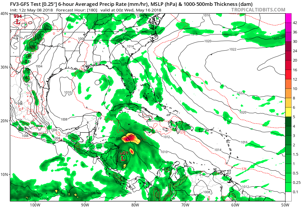
FV3-GFS has it again where development starts in the SW Caribbean in about a week or so from now lifting north, 180 image below:
1 likes
-
NotSparta
- Professional-Met
- Posts: 1677
- Age: 24
- Joined: Fri Aug 18, 2017 8:24 am
- Location: Naples, FL
- Contact:
Re: 2018 Tropics: Global Model Runs Discussion (Out to day 16)
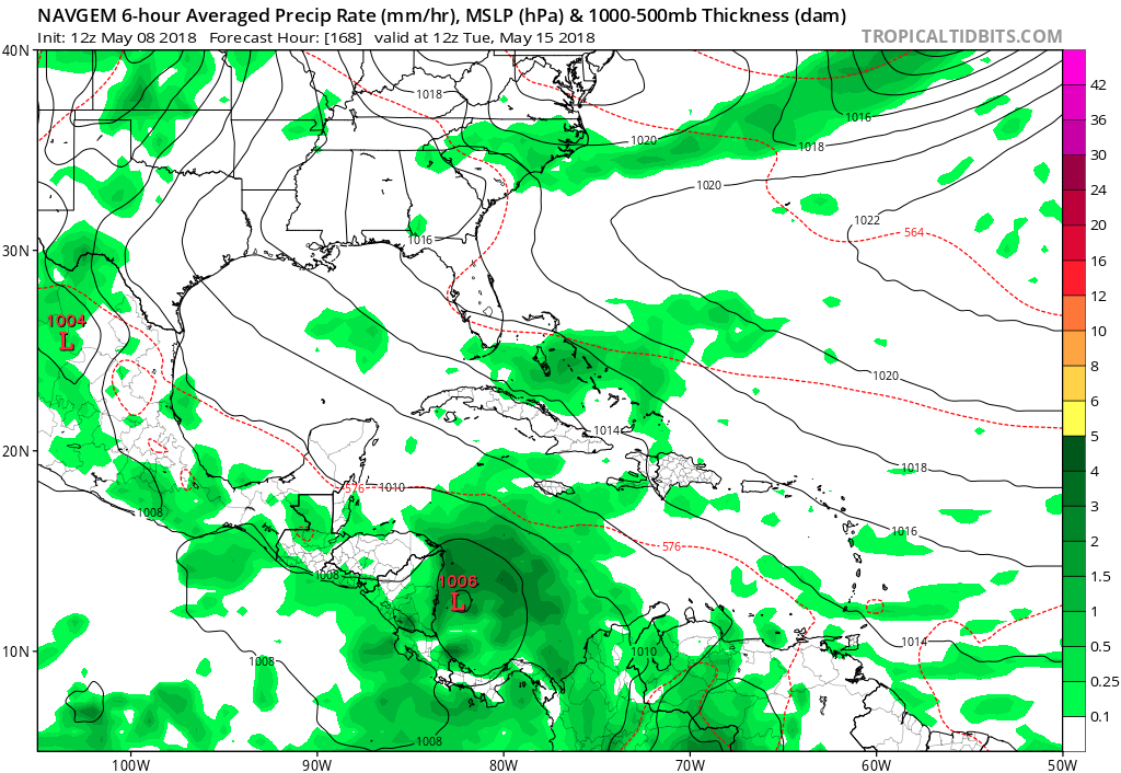
NAVGEM is on board, 1st non-GFS or GEFS model to show it. imo, it's more likely that this disturbance forms in the EPAC, but models like the SW Caribbean
0 likes
This post was probably an opinion of mine, and in no way is official. Please refer to http://www.hurricanes.gov for official tropical analysis and advisories.
My website, with lots of tropical wx graphics, including satellite and recon: http://cyclonicwx.com
My website, with lots of tropical wx graphics, including satellite and recon: http://cyclonicwx.com
-
WeatherEmperor
- S2K Supporter
- Posts: 4806
- Age: 42
- Joined: Thu Sep 04, 2003 2:54 pm
- Location: South Florida
Re: 2018 Tropics: Global Model Runs Discussion (Out to day 16)
FV3 at 240 hours. Just for fun.....

Sent from my iPhone using Tapatalk
Sent from my iPhone using Tapatalk
1 likes
-
AutoPenalti
- Category 5
- Posts: 4091
- Age: 29
- Joined: Mon Aug 17, 2015 4:16 pm
- Location: Ft. Lauderdale, Florida
Re: 2018 Tropics: Global Model Runs Discussion (Out to day 16)
I’m having doubts even with the slight increase in model support, it could be EPAC as well and with possible delays on timeframe with genesis.
2 likes
The posts in this forum are NOT official forecasts and should not be used as such. They are just the opinion of the poster and may or may not be backed by sound meteorological data. They are NOT endorsed by any professional institution or STORM2K. For official information, please refer to products from the NHC and NWS.
Model Runs Cheat Sheet:
GFS (5:30 AM/PM, 11:30 AM/PM)
HWRF, GFDL, UKMET, NAVGEM (6:30-8:00 AM/PM, 12:30-2:00 AM/PM)
ECMWF (1:45 AM/PM)
TCVN is a weighted averaged
-
gatorcane
- S2K Supporter
- Posts: 23708
- Age: 48
- Joined: Sun Mar 13, 2005 3:54 pm
- Location: Boca Raton, FL
Re: 2018 Tropics: Global Model Runs Discussion (Out to day 16)
Wow the FV3 GFS is going bonkers with this system:
Wasn't this model supposed to reduce phantom storms like this?
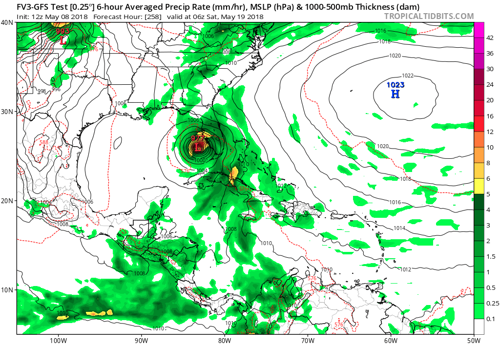
Wasn't this model supposed to reduce phantom storms like this?
2 likes
-
TheStormExpert
Re: 2018 Tropics: Global Model Runs Discussion (Out to day 16)
gatorcane wrote:Wow the FV3 GFS is going bonkers with this system:
Wasn't this model supposed to reduce phantom storms like this?
If I had to take a guess it looks like a potential convective feedback issues is going to be a MAJOR problem with this new-GFS. Correct me if I’m wrong, Alyono knows more about this.
0 likes
Re: 2018 Tropics: Global Model Runs Discussion (Out to day 16)
Last edited by LarryWx on Tue May 08, 2018 1:59 pm, edited 1 time in total.
0 likes
Personal Forecast Disclaimer:
The posts in this forum are NOT official forecasts and should not be used as such. They are just the opinion of the poster and may or may not be backed by sound meteorological data. They are NOT endorsed by any professional institution or storm2k.org. For official information, please refer to the NHC and NWS products.
The posts in this forum are NOT official forecasts and should not be used as such. They are just the opinion of the poster and may or may not be backed by sound meteorological data. They are NOT endorsed by any professional institution or storm2k.org. For official information, please refer to the NHC and NWS products.
Who is online
Users browsing this forum: Google Adsense [Bot], mixedDanilo.E and 44 guests