...SPECIAL FEATURE...
A persistent broad area of low pressure is analyzed as a 1011 mb
surface low at 10N119W. Environmental conditions are favorable
for slow development over the next few days as the low moves
moves northwestward. A blend of global guidance results in a
solution of a surface low near 11N121W this evening accompanied
by strong to near gale force winds. The forecast is for gale
force conditions to develop within 90 nm over the northwest
quadrant of the low near 12N122W on Wed morning. Gale conditions
should continue through Fri when environmental conditions will
become less favorable. This system has the potential to become a
tropical cyclone.
EPAC: ONE-E - Post-Tropical
Moderator: S2k Moderators
-
cycloneye

- Admin

- Posts: 149366
- Age: 69
- Joined: Thu Oct 10, 2002 10:54 am
- Location: San Juan, Puerto Rico
Re: EPAC: INVEST 90E
1 likes
Visit the Caribbean-Central America Weather Thread where you can find at first post web cams,radars
and observations from Caribbean basin members Click Here
and observations from Caribbean basin members Click Here
-
AnnularCane

- S2K Supporter

- Posts: 2959
- Joined: Thu Jun 08, 2006 9:18 am
- Location: Wytheville, VA
-
cycloneye
- Admin
- Posts: 149366
- Age: 69
- Joined: Thu Oct 10, 2002 10:54 am
- Location: San Juan, Puerto Rico
Re: EPAC: INVEST 90E
Special Tropical Weather Outlook
NWS National Hurricane Center Miami FL
1030 AM PDT Tue May 8 2018
For the eastern North Pacific...east of 140 degrees west longitude:
Satellite images indicate that a broad area of low pressure has
developed in association with the region of disturbed weather
located a little more than 1000 miles southwest of the southern tip
of the Baja California peninsula. The system is gradually becoming
better organized and environmental conditions appear to be favorable
for some additional development. A tropical depression could form
from this system later today or Wednesday before the disturbance
moves slowly northwestward toward unfavorable upper-level winds
later this week. The next Special Tropical Weather Outlook on this
system will be issued by 11 AM PDT Wednesday, or earlier, if
necessary.
* Formation chance through 48 hours...medium...50 percent.
* Formation chance through 5 days...medium...50 percent.
$$
Forecaster Avila
0 likes
Visit the Caribbean-Central America Weather Thread where you can find at first post web cams,radars
and observations from Caribbean basin members Click Here
and observations from Caribbean basin members Click Here
-
NotSparta

- Professional-Met

- Posts: 1677
- Age: 24
- Joined: Fri Aug 18, 2017 8:24 am
- Location: Naples, FL
- Contact:
Re: EPAC: INVEST 90E
0 likes
This post was probably an opinion of mine, and in no way is official. Please refer to http://www.hurricanes.gov for official tropical analysis and advisories.
My website, with lots of tropical wx graphics, including satellite and recon: http://cyclonicwx.com
My website, with lots of tropical wx graphics, including satellite and recon: http://cyclonicwx.com
-
Kingarabian

- S2K Supporter
- Posts: 16353
- Joined: Sat Aug 08, 2009 3:06 am
- Location: Honolulu, Hawaii
Re: EPAC: INVEST 90E
Just needs to build and maintain some convection and its classifiable.
1 likes
RIP Kobe Bryant
-
Kingarabian
- S2K Supporter
- Posts: 16353
- Joined: Sat Aug 08, 2009 3:06 am
- Location: Honolulu, Hawaii

-
NotSparta
- Professional-Met
- Posts: 1677
- Age: 24
- Joined: Fri Aug 18, 2017 8:24 am
- Location: Naples, FL
- Contact:
Re: EPAC: INVEST 90E
Kingarabian wrote:Solid outflow already:
I think the PV streamer that initiated the convection in the system also is providing outflow. Also, it's really starting to spin!
0 likes
This post was probably an opinion of mine, and in no way is official. Please refer to http://www.hurricanes.gov for official tropical analysis and advisories.
My website, with lots of tropical wx graphics, including satellite and recon: http://cyclonicwx.com
My website, with lots of tropical wx graphics, including satellite and recon: http://cyclonicwx.com
-
Sciencerocks
- Category 5

- Posts: 10181
- Age: 40
- Joined: Thu Jul 06, 2017 1:51 am
Re: EPAC: INVEST 90E
Tropical depression probably within the next 12 hours based on that satellite look, imo. Probably Tropical storm by this time tomorrow.
3 likes
-
cycloneye
- Admin
- Posts: 149366
- Age: 69
- Joined: Thu Oct 10, 2002 10:54 am
- Location: San Juan, Puerto Rico
Re: EPAC: INVEST 90E
When one of them says this,I guess there is a good chance.
@EricBlake12
Goes 16 over Ep90 today in the eastern Pacific - decent chance of formation next couple of days
@EricBlake12
Goes 16 over Ep90 today in the eastern Pacific - decent chance of formation next couple of days
0 likes
Visit the Caribbean-Central America Weather Thread where you can find at first post web cams,radars
and observations from Caribbean basin members Click Here
and observations from Caribbean basin members Click Here
-
NotSparta
- Professional-Met
- Posts: 1677
- Age: 24
- Joined: Fri Aug 18, 2017 8:24 am
- Location: Naples, FL
- Contact:
Re: EPAC: INVEST 90E
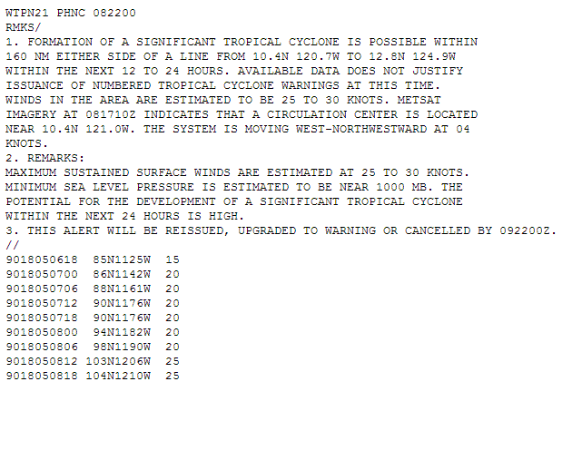
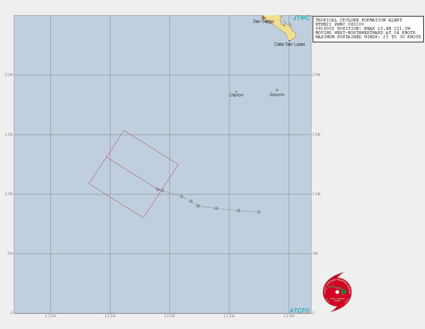
TCFA issued.
0 likes
This post was probably an opinion of mine, and in no way is official. Please refer to http://www.hurricanes.gov for official tropical analysis and advisories.
My website, with lots of tropical wx graphics, including satellite and recon: http://cyclonicwx.com
My website, with lots of tropical wx graphics, including satellite and recon: http://cyclonicwx.com
-
cycloneye
- Admin
- Posts: 149366
- Age: 69
- Joined: Thu Oct 10, 2002 10:54 am
- Location: San Juan, Puerto Rico
Re: EPAC: INVEST 90E
Will 90E form into a Tropical Depression before 18z on May 9th? That was the date and time TD formed in 2017 making it the earliest TC forming in EPAC and later became TS Adrian on the 10th.
2 likes
Visit the Caribbean-Central America Weather Thread where you can find at first post web cams,radars
and observations from Caribbean basin members Click Here
and observations from Caribbean basin members Click Here
-
cycloneye
- Admin
- Posts: 149366
- Age: 69
- Joined: Thu Oct 10, 2002 10:54 am
- Location: San Juan, Puerto Rico
Re: EPAC: INVEST 90E
@wxtrackercody
Watching towers grow with #90E as the sun sets. It has all but attained tropical depression status. Waiting on word from NHC.
https://twitter.com/wxtrackercody/status/994041115400724480
Watching towers grow with #90E as the sun sets. It has all but attained tropical depression status. Waiting on word from NHC.
https://twitter.com/wxtrackercody/status/994041115400724480
2 likes
Visit the Caribbean-Central America Weather Thread where you can find at first post web cams,radars
and observations from Caribbean basin members Click Here
and observations from Caribbean basin members Click Here

Re: EPAC: INVEST 90E
I think if it can maintain or grow the convection it currently has, it would be very reasonable for the NHC to declare this within the next 12 hours.
1 likes
Solar Aquarian
Lunar Cancerian
 Sagittarian
Lunar Cancerian
-
StruThiO

- Category 3

- Posts: 821
- Age: 26
- Joined: Fri Sep 15, 2017 5:51 am
- Location: Currently Portland, OR. Raised in Jax, FL.
Re: EPAC: INVEST 90E
now at 70/70
Special Tropical Weather Outlook
NWS National Hurricane Center Miami FL
1215 AM PDT Wed May 9 2018
For the eastern North Pacific...east of 140 degrees west longitude:
Satellite images indicate that showers and thunderstorms have become
a little better organized this morning in association with a broad
area of low pressure located more than 1100 miles southwest of the
southern tip of the Baja California peninsula. Although recent
satellite-derived surface wind data indicate winds of 30 to 35 mph
were occurring on the northwest side of the disturbance, the
low-level circulation remains elongated. However, only a slight
increase in the amount and organization of the thunderstorm activity
or an improvement in the surface wind field would result in the
formation of a tropical depression later today while the system
moves northwestward at around 10 mph. By late Thursday, upper-level
winds are expected to become unfavorable for tropical cyclone
formation. A Special Tropical Weather Outlook on this system will be
issued by 11 AM PDT later today, if necessary.
* Formation chance through 48 hours...high...70 percent.
* Formation chance through 5 days...high...70 percent.
0 likes
-
euro6208
Re: EPAC: INVEST 90E
Wow...the way this had all the attention in the beginning you would think something *Major*...Now GFS joins EURO on a weak fish... 
0 likes
-
StruThiO
- Category 3
- Posts: 821
- Age: 26
- Joined: Fri Sep 15, 2017 5:51 am
- Location: Currently Portland, OR. Raised in Jax, FL.
Re: EPAC: INVEST 90E
euro6208 wrote:Wow...the way this had all the attention in the beginning you would think something *Major*...Now GFS joins EURO on a weak fish...
because of the potential for a record breaking early formation
1 likes
-
euro6208
Re: EPAC: INVEST 90E
StruThiO wrote:euro6208 wrote:Wow...the way this had all the attention in the beginning you would think something *Major*...Now GFS joins EURO on a weak fish...
because of the potential for a record breaking early formation
Had to say it sorry...
0 likes
-
StruThiO
- Category 3
- Posts: 821
- Age: 26
- Joined: Fri Sep 15, 2017 5:51 am
- Location: Currently Portland, OR. Raised in Jax, FL.
Re: EPAC: INVEST 90E
Had to say it sorry...[/quote]euro6208 wrote:
No, I get it, feels like 90E has gotten as much attention as a disturbance than Jelawat did as a super typhoon. Again, to be fair a record is on the line until later today.
1 likes
-
cycloneye
- Admin
- Posts: 149366
- Age: 69
- Joined: Thu Oct 10, 2002 10:54 am
- Location: San Juan, Puerto Rico
Re: EPAC: INVEST 90E
@MJVentrice
Invest 90E over the Eastern Pacific definitely warrants monitoring as there is a robust mid-level vortex, though the disturbance seems to be lacking deep convection at the current time frame.
https://twitter.com/MJVentrice/status/994242519432081414
Invest 90E over the Eastern Pacific definitely warrants monitoring as there is a robust mid-level vortex, though the disturbance seems to be lacking deep convection at the current time frame.
https://twitter.com/MJVentrice/status/994242519432081414
0 likes
Visit the Caribbean-Central America Weather Thread where you can find at first post web cams,radars
and observations from Caribbean basin members Click Here
and observations from Caribbean basin members Click Here
-
cycloneye
- Admin
- Posts: 149366
- Age: 69
- Joined: Thu Oct 10, 2002 10:54 am
- Location: San Juan, Puerto Rico
Re: EPAC: INVEST 90E
Time is running out.
...SPECIAL FEATURE...
A broad and elongated area of low pressure is analyzed as a 1008
mb surface low at 11N123W. Convection has slightly decreased
during the last several hours being mainly concentrated in the
west semicircle of the low within 225 nm of its center. A blend
of global guidance results in a solution of a surface low, or
possible tropical cyclone near 12N124W on Thu afternoon with
minimal gale force winds mainly over the north semicircle. The
system is forecast to continue northwestward into an area of
increasing unfavorable shear on Thu, likely hindering further
development of this system. Model guidance suggest winds will
diminish to near gale force by Thu night/early on Fri.
1 likes
Visit the Caribbean-Central America Weather Thread where you can find at first post web cams,radars
and observations from Caribbean basin members Click Here
and observations from Caribbean basin members Click Here
Who is online
Users browsing this forum: No registered users and 27 guests