Western Caribbean Area of Interest: (Is INVEST 90L)
Moderator: S2k Moderators
Forum rules

The posts in this forum are NOT official forecasts and should not be used as such. They are just the opinion of the poster and may or may not be backed by sound meteorological data. They are NOT endorsed by any professional institution or STORM2K. For official information, please refer to products from the National Hurricane Center and National Weather Service.
Re: SW Caribbean Area of Interest
This could be the almost annual June storm arriving a few days early just in time to disrupt holiday weekend activities for Florida. Memorial day tends to be the best of the Summer holidays for Florida (weatherwise) and it's logical from a climo perspective to plan vacations at that time. That bet may go south this year depending on how things pan out. Some areas of Florida have gotten very heavy rain lately so flooding and some severe risk could be an issue even with a weak, sheared system. At the very least it looks like high PWAT plumes of moisture and attendant rainfall will remain an issue..
1 likes
-
cycloneye

- Admin

- Posts: 148892
- Age: 69
- Joined: Thu Oct 10, 2002 10:54 am
- Location: San Juan, Puerto Rico
Re: SW Caribbean Area of Interest
The ICON model is also among the models that develops this.This is at 180 hours.


0 likes
Visit the Caribbean-Central America Weather Thread where you can find at first post web cams,radars
and observations from Caribbean basin members Click Here
and observations from Caribbean basin members Click Here

Re: SW Caribbean Area of Interest
cycloneye wrote:The ICON model is also among the models that develops this.
Classic June structure...maybe tornadoes over FL as it moves N...definite shear and high capes
0 likes
Re: SW Caribbean Area of Interest
One more point on the Euro...it has a lot of energy. Multiple centers of vorticity. If it did bundle, then it would get interesting...
0 likes
-
gatorcane

- S2K Supporter

- Posts: 23708
- Age: 48
- Joined: Sun Mar 13, 2005 3:54 pm
- Location: Boca Raton, FL
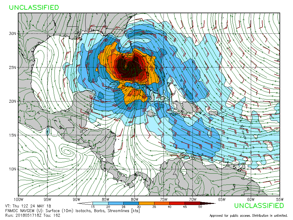
Re: SW Caribbean Area of Interest
18Z NAVGEM sends this NE out of the Caribbean and through South Florida as what looks like a hurricane:
1 likes
-
cycloneye
- Admin
- Posts: 148892
- Age: 69
- Joined: Thu Oct 10, 2002 10:54 am
- Location: San Juan, Puerto Rico
Re: SW Caribbean Area of Interest
@BigJoeBastardi
let me be clear on idea on early season development, Its not based on GFS runs, its based on analogs to past patterns that produced it, whether model sees it or not, and the phase 2 MJO rotation which is a known positive for enhanced activity in close to US Analog to 2012 helps
https://twitter.com/BigJoeBastardi/status/997267812094799872
0 likes
Visit the Caribbean-Central America Weather Thread where you can find at first post web cams,radars
and observations from Caribbean basin members Click Here
and observations from Caribbean basin members Click Here
-
gatorcane
- S2K Supporter
- Posts: 23708
- Age: 48
- Joined: Sun Mar 13, 2005 3:54 pm
- Location: Boca Raton, FL
Re: SW Caribbean Area of Interest
drezee wrote:One more point on the Euro...it has a lot of energy. Multiple centers of vorticity. If it did bundle, then it would get interesting...
Let us not forget these are the same models that on several occasions last year took being within 5 days or even less until they really showed development. So you never know, could this end up stronger and more organized than we think if it develops? Climo argues against that but you never know.
1 likes
-
toad strangler

- S2K Supporter
- Posts: 4546
- Joined: Sun Jul 28, 2013 3:09 pm
- Location: Earth
- Contact:
Re: SW Caribbean Area of Interest
Dylan wrote:Dylan wrote:The European ensembles are lighting up like a Christmas tree with this potential system. Still a long way out, but we’ve seen this movie before. Definitely has my attention, along with others.
I’d also like to mention that I wouldn’t take the doomsday models seriously. It’s mid-May. Conditions will be marginal at best in the Gulf, and that might be a generous word to use based on ensemble solutions. If anything comes out of this, expect your typical early season tropical storm. Not a Category 3, that’s ludicrous based on the current and forecasted conditions.
I mentioned Andrea 2013 earlier today. I think it's a very strong analog for this situation.
https://www.nhc.noaa.gov/data/tcr/AL012013_Andrea.pdf
https://en.wikipedia.org/wiki/Tropical_Storm_Andrea_(2013)
1 likes
My Weather Station
https://www.wunderground.com/dashboard/pws/KFLPORTS603
https://www.wunderground.com/dashboard/pws/KFLPORTS603
-
TheStormExpert
Re: SW Caribbean Area of Interest
gatorcane wrote:drezee wrote:One more point on the Euro...it has a lot of energy. Multiple centers of vorticity. If it did bundle, then it would get interesting...
Let us not forget these are the same models that on several occasions last year took being within 5 days or even less until they really showed development. So you never know, could this end up stronger and more organized than we think if it develops? Climo argues against that but you never know.
If I remember correctly the Euro wasn’t the best within its 8-10 day range last season. Though I’d bet what it’s showing on its recent 12z run over crazy Cat.3 solutions like what the GFS/FV3-GFS is showing.
0 likes
-
TheStormExpert
Re: SW Caribbean Area of Interest
toad strangler wrote:Dylan wrote:Dylan wrote:The European ensembles are lighting up like a Christmas tree with this potential system. Still a long way out, but we’ve seen this movie before. Definitely has my attention, along with others.
I’d also like to mention that I wouldn’t take the doomsday models seriously. It’s mid-May. Conditions will be marginal at best in the Gulf, and that might be a generous word to use based on ensemble solutions. If anything comes out of this, expect your typical early season tropical storm. Not a Category 3, that’s ludicrous based on the current and forecasted conditions.
I mentioned Andrea 2013 earlier today. I think it's a very strong analog for this situation.
https://www.nhc.noaa.gov/data/tcr/AL012013_Andrea.pdf
https://en.wikipedia.org/wiki/Tropical_Storm_Andrea_(2013)
Or even Tropical Storm Barry (2007)
https://en.m.wikipedia.org/wiki/Tropical_Storm_Barry_(2007)
1 likes
-
cycloneye
- Admin
- Posts: 148892
- Age: 69
- Joined: Thu Oct 10, 2002 10:54 am
- Location: San Juan, Puerto Rico
Re: SW Caribbean Area of Interest
Already a small pink.

0 likes
Visit the Caribbean-Central America Weather Thread where you can find at first post web cams,radars
and observations from Caribbean basin members Click Here
and observations from Caribbean basin members Click Here
-
TheStormExpert
Re: SW Caribbean Area of Interest
Here’s the 12z EPS Ensembles. In fact they’re are more bullish with this potential system, with several showing a minimal Cat.1 hurricane.


2 likes
-
cycloneye
- Admin
- Posts: 148892
- Age: 69
- Joined: Thu Oct 10, 2002 10:54 am
- Location: San Juan, Puerto Rico
Re: SW Caribbean Area of Interest
@BigJoeBastardi
I say when it comes to modeling, judge the tree by the fruit on it, And let freedom ring, GFS very often will show something dozens of times before it pops, But phase 2 MJO next week has been on our radar for quite some time, and that is concern
https://twitter.com/BigJoeBastardi/status/997268748120875008
0 likes
Visit the Caribbean-Central America Weather Thread where you can find at first post web cams,radars
and observations from Caribbean basin members Click Here
and observations from Caribbean basin members Click Here
-
Dylan

- Professional-Met

- Posts: 338
- Age: 31
- Joined: Mon May 31, 2010 9:50 am
- Location: New Orleans, LA
Re: SW Caribbean Area of Interest
Alyono wrote:Dylan wrote:Dylan wrote:The European ensembles are lighting up like a Christmas tree with this potential system. Still a long way out, but we’ve seen this movie before. Definitely has my attention, along with others.
I’d also like to mention that I wouldn’t take the doomsday models seriously. It’s mid-May. Conditions will be marginal at best in the Gulf, and that might be a generous word to use based on ensemble solutions. If anything comes out of this, expect your typical early season tropical storm. Not a Category 3, that’s ludicrous based on the current and forecasted conditions.
if this were to become a hurricane, it probably would have the best chance to do so east of Florida and the Carolinas. May have more baroclinic forcing there, as well as more divergent flow
Based on 500mb heights forecasted by the EPS along with teleconnections, I don’t think that strong of a weakness will be in place for such a NE motion across FL Into the Bahamas ect. This is more likely a Gulf problem, albeit a weak system. I think what we’re seeing is the typical eastward bias typically displayed by the GFS. Most EPS ensembles shows the Gulf.
3 likes
Georges('98), Allison('01), Isidore('02), Lili('02), Frances('04) Ivan('04), Cindy('05), Katrina('05), Rita('05), Gustav('08), Isaac('12), Matthew('16), Harvey('17), Irma('17), Nate ('17), Ida ('21).
-
gatorcane
- S2K Supporter
- Posts: 23708
- Age: 48
- Joined: Sun Mar 13, 2005 3:54 pm
- Location: Boca Raton, FL
Re: SW Caribbean Area of Interest
Dylan wrote:Alyono wrote:Dylan wrote:
I’d also like to mention that I wouldn’t take the doomsday models seriously. It’s mid-May. Conditions will be marginal at best in the Gulf, and that might be a generous word to use based on ensemble solutions. If anything comes out of this, expect your typical early season tropical storm. Not a Category 3, that’s ludicrous based on the current and forecasted conditions.
if this were to become a hurricane, it probably would have the best chance to do so east of Florida and the Carolinas. May have more baroclinic forcing there, as well as more divergent flow
Based on 500mb heights forecasted by the EPS along with teleconnections, I don’t think that strong of a weakness will be in place for such a NE motion across FL Into the Bahamas ect. This is more likely a Gulf problem, albeit a weak system. I think what we’re seeing is the typical eastward bias typically displayed by the crappy MU. Most EPS ensembles shows the Gulf.
I was thinking the same but the CMC, ECMWF operational, and NAVGEM (not to mention most of the GFS ensembles now) show a NE or NNE motion due to a pretty deep low that develops over SE Canada which further erodes the Bermuda High.
Last edited by gatorcane on Thu May 17, 2018 8:36 pm, edited 1 time in total.
1 likes
-
floridasun78
- Category 5

- Posts: 3755
- Joined: Sun May 17, 2009 10:16 pm
- Location: miami fl
Re: SW Caribbean Area of Interest
i waiting for next week too see what my miami weather office say about long weekend because we alot event here at beach people coming down long weekend beach going pack hotel all soldout
0 likes

-
Evil Jeremy

- S2K Supporter
- Posts: 5463
- Age: 32
- Joined: Mon Apr 10, 2006 2:10 pm
- Location: Los Angeles, CA
Re: SW Caribbean Area of Interest
Oh boy, time to break out that bookmarks bar! Couple weeks early, too. Happy pre-season, everyone.
Going by this afternoon's models, impact to the E-GOM would be in 8-10 day range. That's well past a reliable range, but not outside the realm of possibility. Sometimes, we have seen model scenarios play out from even 14 days out.
Going by this afternoon's models, impact to the E-GOM would be in 8-10 day range. That's well past a reliable range, but not outside the realm of possibility. Sometimes, we have seen model scenarios play out from even 14 days out.
3 likes
Frances 04 / Jeanne 04 / Katrina 05 / Wilma 05 / Fay 08 / Debby 12 / Andrea 13 / Colin 16 / Hermine 16 / Matthew 16 / Irma 17
-
floridasun78
- Category 5
- Posts: 3755
- Joined: Sun May 17, 2009 10:16 pm
- Location: miami fl
Re: SW Caribbean Area of Interest
Evil Jeremy wrote:Oh boy, time to break out that bookmarks bar! Couple weeks early, too. Happy pre-season, everyone.
Going by this afternoon's models, impact to the E-GOM would be in 8-10 day range. That's well past a reliable range, but not outside the realm of possibility. Sometimes, we have seen model scenarios play out from even 14 days out.
hope this all wrong too many plan for long weekend see system blow long weekend too kingdom come here south fl
0 likes
Who is online
Users browsing this forum: Ulf and 181 guests