Western Caribbean Area of Interest: (Is INVEST 90L)
Moderator: S2k Moderators
Forum rules

The posts in this forum are NOT official forecasts and should not be used as such. They are just the opinion of the poster and may or may not be backed by sound meteorological data. They are NOT endorsed by any professional institution or STORM2K. For official information, please refer to products from the National Hurricane Center and National Weather Service.
-
gatorcane

- S2K Supporter

- Posts: 23708
- Age: 48
- Joined: Sun Mar 13, 2005 3:54 pm
- Location: Boca Raton, FL
Re: Western Caribbean Area of Interest: Special Tropical Weather Outlook-0%-20%
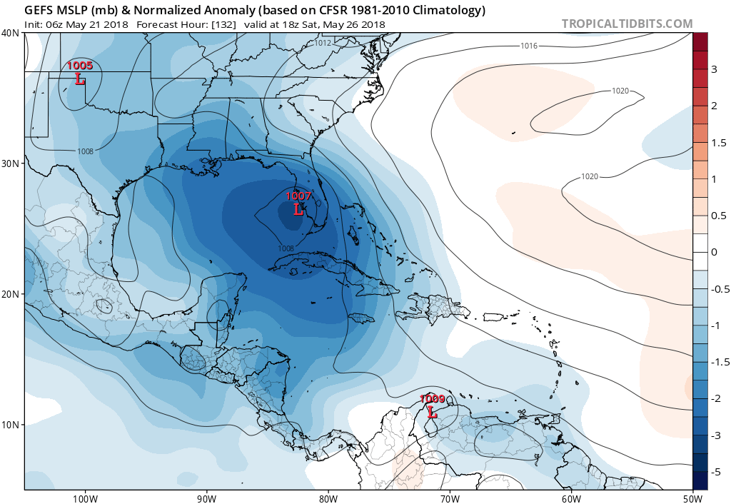
06Z GFS Ensemble mean favoring EGOM/Florida solution. Looks like the mean shifted back a bit east from the 00Z:
0 likes
-
marionstorm
- Tropical Depression

- Posts: 94
- Joined: Wed Aug 31, 2016 4:46 am
Re: Western Caribbean Area of Interest: Special Tropical Weather Outlook-0%-20%
I'm very worried about this storm because I have Duke Energy and it doesnt take much. 
0 likes
-
Stormcenter
- S2K Supporter
- Posts: 6689
- Joined: Wed Sep 03, 2003 11:27 am
- Location: Houston, TX
Re: Western Caribbean Area of Interest: Special Tropical Weather Outlook-0%-20%
I would not bet a penny on the GFS or any other model when we have nothing organized yet. IMO
1 likes
Re: Western Caribbean Area of Interest
cycloneye wrote:@BigJoeBastardi
The reason I would be surprised if no development is because a strong phase 2/3 MJO rotation like this is like throwing a match on the waters near the US for development, Been saying since early May look out late May for this. Not model magic, just lining up against knowns
https://twitter.com/BigJoeBastardi/status/998538770776559616
Regardless of the MJO, based on longterm late May climo and there currently being nothing well organized, nobody should be surprised if no TS were to come out of this. Keep in mind that there have been only 5 TS on record that had a genesis during 5/21-31 in the W Car/GOM in 167 years. I'm sure the MJO was favorable in many of the years that ended up with no development when we're talking about this many years of climo. I'm still at a 33% chance of TD genesis for now (which is very high for late May) and a 5% chance of a FL TS landfall (also very high for late May). I'll adjust these up or down as we move forward. There could just as easily be no more than a very broad low that never gets past the TD stage or doesn't even get classified as a TC. Or maybe there will be a TD or even a TS that never hits FL as per many of the current model runs. Or maybe there will be a TS and it weakens to below TS strength before hitting FL. So many possibilities other than a TS hit on FL.
Last edited by LarryWx on Mon May 21, 2018 9:37 am, edited 1 time in total.
4 likes
Personal Forecast Disclaimer:
The posts in this forum are NOT official forecasts and should not be used as such. They are just the opinion of the poster and may or may not be backed by sound meteorological data. They are NOT endorsed by any professional institution or storm2k.org. For official information, please refer to the NHC and NWS products.
The posts in this forum are NOT official forecasts and should not be used as such. They are just the opinion of the poster and may or may not be backed by sound meteorological data. They are NOT endorsed by any professional institution or storm2k.org. For official information, please refer to the NHC and NWS products.
-
AdamFirst

- S2K Supporter
- Posts: 2490
- Age: 36
- Joined: Thu Aug 14, 2008 10:54 am
- Location: Port Saint Lucie, FL
Re: Western Caribbean Area of Interest: Special Tropical Weather Outlook-0%-20%
Another thing that's concerning for me in terms of the GFS runs is that the moisture conveyor from the Caribbean seems to stay intact for several days after a potential system passes over Florida. It may not be the end of the flooding threat.
0 likes
Dolphins Marlins Canes Golden Panthers HEAT
Andrew 1992 - Irene 1999 - Frances 2004 - Jeanne 2004 - Wilma 2005 - Fay 2008 - Isaac 2012 - Matthew 2016 - Irma 2017 - Dorian 2019 - Ian 2022 - Nicole 2022 - Milton 2024
Andrew 1992 - Irene 1999 - Frances 2004 - Jeanne 2004 - Wilma 2005 - Fay 2008 - Isaac 2012 - Matthew 2016 - Irma 2017 - Dorian 2019 - Ian 2022 - Nicole 2022 - Milton 2024
-
stormlover2013
Re: Western Caribbean Area of Interest: Special Tropical Weather Outlook-0%-20%
I don't like to do model wars, but right now is a interesting day, lets see what the models show today, ICON, EURO, CMC western and GFS way to the east.........just depends where the center forms if one, But I will say this if the western solution pans out the pattern seems fit to meander around with high pressure to its east and west and even the GFS shows that.
0 likes

Re: Western Caribbean Area of Interest: Special Tropical Weather Outlook-0%-20%
Keep in mind that nothing has formed yet and the models are all over the place.
1 likes

Re: Western Caribbean Area of Interest: Special Tropical Weather Outlook-0%-20%
Models look messy to me...NAVGEM being showing a TS where’s the GFS is showing less organized system. When is doubt I go with the EURO which has been splitting the difference in last nights run..JMO
0 likes
-
cycloneye

- Admin

- Posts: 149372
- Age: 69
- Joined: Thu Oct 10, 2002 10:54 am
- Location: San Juan, Puerto Rico
Re: Western Caribbean Area of Interest
Northern GOM has warmed a lot in the past few days and that could aid development of anything going that way.Of course other factors come into play that could not favor development.

0 likes
Visit the Caribbean-Central America Weather Thread where you can find at first post web cams,radars
and observations from Caribbean basin members Click Here
and observations from Caribbean basin members Click Here
Re: Western Caribbean Area of Interest: Special Tropical Weather Outlook-0%-20%
ROCK wrote:Models look messy to me...NAVGEM being showing a TS where’s the GFS is showing less organized system. When is doubt I go with the EURO which has been splitting the difference in last nights run..JMO
Hey Rock always good to see you on here.
0 likes
-
SFLcane

- S2K Supporter
- Posts: 10281
- Age: 48
- Joined: Sat Jun 05, 2010 1:44 pm
- Location: Lake Worth Florida
Re: Western Caribbean Area of Interest: Special Tropical Weather Outlook-0%-20%
AdamFirst wrote:Another thing that's concerning for me in terms of the GFS runs is that the moisture conveyor from the Caribbean seems to stay intact for several days after a potential system passes over Florida. It may not be the end of the flooding threat.
This is whats all about more rain for Florida. An organized system is not expected.
0 likes
-
Shell Mound
- Category 5

- Posts: 2432
- Age: 33
- Joined: Thu Sep 07, 2017 3:39 pm
- Location: St. Petersburg, FL → Scandinavia
Re: Western Caribbean Area of Interest
Note that if an organised system (TD or stronger) were to develop in the Gulf of Mexico rather than the western Caribbean, it would be a case of development in the subtropics rather than the deep tropics. In other words, it could no longer be used as evidence that 2018 might be an active season. Anyway, given that the weakness will be in the low levels with ridging increasing farther up, this would be a case where a weaker system would head east and a stronger (that is, deeper, vertically stacked) system west. The GEFS also shows more influence from the subtropical jet than the EPS, perhaps due to convective feedback (feel free to correct me). Since the EPS usually has a better handle on convection and large-scale patterns, I would favour the EPS for its handling of the ridging and cutoff low. The EPS is stronger and farther SE (NW) with the overall ridging (cutoff low), so convection might tend to focus farther W over the Gulf, giving credence to the EPS solutions that focus on the central Gulf Coast. Anyway, the environment still looks so unfavourable for development that I would expect a drenching sub-TS.
2 likes
CVW / MiamiensisWx / Shell Mound
The posts in this forum are NOT official forecasts and should not be used as such. They are just the opinion of the poster and may or may not be backed by sound meteorological data. They are NOT endorsed by any professional institution or STORM2K. For official information, please refer to products from the NHC and NWS.
-
TheStormExpert
Re: Western Caribbean Area of Interest
Funny that the GFS was the first and only model to sniff this potential TC out weeks in advance and now it’s the only model to show little to no development from it with a track solution that’s basically completely different from the rest. The GFS sure has a mind of its own! 
0 likes
-
Dylan

- Professional-Met

- Posts: 338
- Age: 31
- Joined: Mon May 31, 2010 9:50 am
- Location: New Orleans, LA
Re: Western Caribbean Area of Interest
With a lot of people expected to be at the beach for Memorial Day weekend, the NHC is probably going to have to be very proactive with how they handle this system.
3 likes
Georges('98), Allison('01), Isidore('02), Lili('02), Frances('04) Ivan('04), Cindy('05), Katrina('05), Rita('05), Gustav('08), Isaac('12), Matthew('16), Harvey('17), Irma('17), Nate ('17), Ida ('21).
-
stormlover2013
Re: Western Caribbean Area of Interest
dylan, do you think the euro could be right with how the upper level pattern is setting up?
0 likes
-
chris_fit

- Category 5
- Posts: 3261
- Age: 43
- Joined: Wed Sep 10, 2003 11:58 pm
- Location: Tampa Bay Area, FL
Re: Western Caribbean Area of Interest
12Z GFS so far coming in weaker and slightly more W with the disorganized mess...
0 likes
-
MississippiWx

- S2K Supporter
- Posts: 1720
- Joined: Sat Aug 14, 2010 1:44 pm
- Location: Hattiesburg, Mississippi
Re: Western Caribbean Area of Interest
Selfishly, I hope whatever this is will come to the Northern Gulf. It hasn’t rained on my farm in South Mississippi in over a month. We have been watching thunderstorms miss us to the north, south, east, and west. No luck! 
Meteorologically speaking, this is a cluster. I’m glad I’m not in the forecast chair. As Dylan alluded to, it is a huge holiday weekend for the beaches. My initial thought is that the GFS is developing the low east due to the strong shear displacing the convection towards Florida. GFS has done well with this in the past, so can’t overlook it. However, it is tough to ignore all the other models pointing to the Northern Gulf.
Anyway, fun times ahead watching this one! Fingers crossed for beneficial rains!
Meteorologically speaking, this is a cluster.
Anyway, fun times ahead watching this one! Fingers crossed for beneficial rains!
0 likes
This post is not an official forecast and should not be used as such. It is just the opinion of MississippiWx and may or may not be backed by sound meteorological data. It is not endorsed by any professional institution including storm2k.org. For Official Information please refer to the NHC and NWS products.
-
chris_fit
- Category 5
- Posts: 3261
- Age: 43
- Joined: Wed Sep 10, 2003 11:58 pm
- Location: Tampa Bay Area, FL
Re: Western Caribbean Area of Interest
12Z GFS - Shifts a little west and a little stronger actually...

0 likes
-
Aric Dunn
- Category 5
- Posts: 21238
- Age: 43
- Joined: Sun Sep 19, 2004 9:58 pm
- Location: Ready for the Chase.
- Contact:
Re: Western Caribbean Area of Interest
The broad trough just north of Honduras has become quite a bit sharper and tilted sw to NE with some larger broad rotation over the last 24 hours. only 24 hours till the euro shows a weak closed wind field and vorticity in that same general area before moving over the Yucatan. I would imagine if the euro did not have be move over land that we would see development with the euro sooner in the NW cariib. so it needs to be watched closer this next 24 hours to see what happens with it.
oddly enough the 12z cmc seems quite reasonable today..
oddly enough the 12z cmc seems quite reasonable today..
0 likes
Note: If I make a post that is brief. Please refer back to previous posts for the analysis or reasoning. I do not re-write/qoute what my initial post said each time.
If there is nothing before... then just ask
Space & Atmospheric Physicist, Embry-Riddle Aeronautical University,
I believe the sky is falling...
If there is nothing before... then just ask
Space & Atmospheric Physicist, Embry-Riddle Aeronautical University,
I believe the sky is falling...
-
MississippiWx
- S2K Supporter
- Posts: 1720
- Joined: Sat Aug 14, 2010 1:44 pm
- Location: Hattiesburg, Mississippi
Re: Western Caribbean Area of Interest
chris_fit wrote:12Z GFS - Shifts a little west and a little stronger actually...
https://i.imgur.com/aG2LPB9.png
Looks like the new GFS has a low pinwheeling around the upper low.
0 likes
This post is not an official forecast and should not be used as such. It is just the opinion of MississippiWx and may or may not be backed by sound meteorological data. It is not endorsed by any professional institution including storm2k.org. For Official Information please refer to the NHC and NWS products.
Who is online
Users browsing this forum: No registered users and 125 guests