
Western Caribbean Area of Interest: (Is INVEST 90L)
Moderator: S2k Moderators
Forum rules

The posts in this forum are NOT official forecasts and should not be used as such. They are just the opinion of the poster and may or may not be backed by sound meteorological data. They are NOT endorsed by any professional institution or STORM2K. For official information, please refer to products from the National Hurricane Center and National Weather Service.
-
cycloneye

- Admin

- Posts: 149372
- Age: 69
- Joined: Thu Oct 10, 2002 10:54 am
- Location: San Juan, Puerto Rico
Re: Western Caribbean Area of Interest
12z CMC is stronger and more west than 00z run.
0 likes
Visit the Caribbean-Central America Weather Thread where you can find at first post web cams,radars
and observations from Caribbean basin members Click Here
and observations from Caribbean basin members Click Here
-
wxman57

- Moderator-Pro Met

- Posts: 23172
- Age: 68
- Joined: Sat Jun 21, 2003 8:06 pm
- Location: Houston, TX (southwest)
Re: Western Caribbean Area of Interest
I still like the GFS solution best. It's the most realistic. The Euro has performed poorly in a high-shear environment in the past. The Canadian, well, it's the Canadian. Always add 180 degrees to the NAVGEM (NOGAPS) forecast track (only semi-joking).
4 likes
-
chris_fit

- Category 5

- Posts: 3261
- Age: 43
- Joined: Wed Sep 10, 2003 11:58 pm
- Location: Tampa Bay Area, FL
Re: Western Caribbean Area of Interest
MississippiWx wrote:chris_fit wrote:12Z GFS - Shifts a little west and a little stronger actually...
[imhttps://i.imgur.com/aG2LPB9.png[/img]
Looks like the new GFS has a low pinwheeling around the upper low.
That's exactly what it looks like - here is a gif of the run so far....

0 likes
Re: Western Caribbean Area of Interest
long time members may recall that Air force met (I sure miss his posts) used to talk about the degree to which sheared Gulf storms end up right of the official forecast as the center gravitates toward convection sheared off to the east. As others have referenced, Debby of 2012 is perhaps an extreme example of this phenomenon. That initial forecast from the NHC was uniquely horrendous. While I am hopeful that somehow Florida gets out from under this persistent plume of gloom, I'm reminded that the weather doesn't care what I think...and I remain pessimistic of our chances. Nevertheless...I suspect most Floridians would be content to share with our neighbors to the west.
1 likes
-
txwatcher91
- Category 5
- Posts: 1498
- Joined: Tue Aug 02, 2005 2:29 pm
Re: Western Caribbean Area of Interest
wxman57 wrote:I still like the GFS solution best. It's the most realistic. The Euro has performed poorly in a high-shear environment in the past. The Canadian, well, it's the Canadian. Always add 180 degrees to the NAVGEM (NOGAPS) forecast track (only semi-joking).
If I remember correctly the Euro was just upgraded last year, correct? If so, what the Euro and other models showed in years past won't matter much since the Euro, CMC, and GFS have all 3 been upgraded in the past 1-2 years so we don't have a lot of data to go on. Having said that, I think something similar to the 06z NAVGEM and 12z GFS is reasonable with a weak TS that heads into the big bend area of FL. Meanwhile the FV3 implementation of the GFS is a disaster... the 06z run took the energy up over FL as a weak sloppy system but then developed a cat 3-4 cane right off the coast of LA... it makes absolutely no sense at all...
0 likes
-
gatorcane

- S2K Supporter

- Posts: 23708
- Age: 48
- Joined: Sun Mar 13, 2005 3:54 pm
- Location: Boca Raton, FL
Re: Western Caribbean Area of Interest
So bottom-line is that we could see development if the trough can get underneath the upper-level low and develop a surface low where upper-level winds would be favorable (Central Gulf) or we will get some kind of sheared, strung-out mess heading towards Florida pivoting around the upper-level low.
I am also leaning towards the GFS given the strong westerly shear and climo but it does seem all alone right now with the other models showing the former.
I am also leaning towards the GFS given the strong westerly shear and climo but it does seem all alone right now with the other models showing the former.
Last edited by gatorcane on Mon May 21, 2018 11:38 am, edited 1 time in total.
1 likes

Re: Western Caribbean Area of Interest
wxman57 wrote:I still like the GFS solution best. It's the most realistic.
If shear is going to be plentiful in the GOM this would seem to me to be most plausible solution. It's hard to go against the Mighty Euro when he doubles down like this but didn't he eventually bow to the GFS last year with Irma or Maria? Seems that the Euro was sticking to his guns on a more westerly track vs the GFS' more easterly solution and then overnight he kinda came around to the GFS and IMO I think he will once again...
0 likes
-
SFLcane

- S2K Supporter
- Posts: 10281
- Age: 48
- Joined: Sat Jun 05, 2010 1:44 pm
- Location: Lake Worth Florida
Re: Western Caribbean Area of Interest
wxman57 wrote:I still like the GFS solution best. It's the most realistic. The Euro has performed poorly in a high-shear environment in the past. The Canadian, well, it's the Canadian. Always add 180 degrees to the NAVGEM (NOGAPS) forecast track (only semi-joking).
So in a sense the deluge continues for Florida into the holiday weekend. Question do u see a tornado threat?
0 likes
-
Aric Dunn
- Category 5
- Posts: 21238
- Age: 43
- Joined: Sun Sep 19, 2004 9:58 pm
- Location: Ready for the Chase.
- Contact:
Re: Western Caribbean Area of Interest
it is worth to note that the gfs keep the current low over the northern gulf coast which then interacts with the developing low in the carrib. the euro and cmc weaken that feature fairly quickly in the next 24 hrs and thus no rotating around each other.
with that feature gone upper winds relax some and thus we get the euro and cmc solutions. so we need to watch what happens with that feature over the northern gulf coast.
with that feature gone upper winds relax some and thus we get the euro and cmc solutions. so we need to watch what happens with that feature over the northern gulf coast.
1 likes
Note: If I make a post that is brief. Please refer back to previous posts for the analysis or reasoning. I do not re-write/qoute what my initial post said each time.
If there is nothing before... then just ask
Space & Atmospheric Physicist, Embry-Riddle Aeronautical University,
I believe the sky is falling...
If there is nothing before... then just ask
Space & Atmospheric Physicist, Embry-Riddle Aeronautical University,
I believe the sky is falling...
-
cycloneye
- Admin
- Posts: 149372
- Age: 69
- Joined: Thu Oct 10, 2002 10:54 am
- Location: San Juan, Puerto Rico
Re: Western Caribbean Area of Interest
12z ICON more east and weaker than 00z run.

0 likes
Visit the Caribbean-Central America Weather Thread where you can find at first post web cams,radars
and observations from Caribbean basin members Click Here
and observations from Caribbean basin members Click Here
Re: Western Caribbean Area of Interest
cycloneye wrote:Northern GOM has warmed a lot in the past few days and that could aid development of anything going that way.Of course other factors come into play that could not favor development.

Perhaps this is a reason a low further west than FL would have a little bit better chance to maintain TS strength if there were a NW Gulf landfall?
Last edited by LarryWx on Mon May 21, 2018 11:54 am, edited 1 time in total.
0 likes
Personal Forecast Disclaimer:
The posts in this forum are NOT official forecasts and should not be used as such. They are just the opinion of the poster and may or may not be backed by sound meteorological data. They are NOT endorsed by any professional institution or storm2k.org. For official information, please refer to the NHC and NWS products.
The posts in this forum are NOT official forecasts and should not be used as such. They are just the opinion of the poster and may or may not be backed by sound meteorological data. They are NOT endorsed by any professional institution or storm2k.org. For official information, please refer to the NHC and NWS products.
-
SEASON_CANCELED

- Category 3

- Posts: 887
- Joined: Mon Jul 06, 2009 5:17 am
- Location: 8 Bit Charlie Sheen
Re: Western Caribbean Area of Interest
Dont need no florida storm please 
On a serious note. I cant think of a time where we have had a wetter start to spring around Tampa area. Its usually bone dry this time of year and we dont get the crazy afternoon pattern till Julyish.
On a serious note. I cant think of a time where we have had a wetter start to spring around Tampa area. Its usually bone dry this time of year and we dont get the crazy afternoon pattern till Julyish.
0 likes
i am a big stupid ugly moron with an ugly face and a big butt and my butt stinks and i like to kiss my own butt
-
Aric Dunn
- Category 5
- Posts: 21238
- Age: 43
- Joined: Sun Sep 19, 2004 9:58 pm
- Location: Ready for the Chase.
- Contact:
Re: Western Caribbean Area of Interest
SEASON_CANCELED wrote:Dont need no florida storm please
On a serious note. I cant think of a time where we have had a wetter start to spring around Tampa area. Its usually bone dry this time of year and we dont get the crazy afternoon pattern till Julyish.
will help for sure. everything from a north south line from Pensacola east is upper 70s. to the west is low to even mid 80s in the loop current and the northern current lobe.
not quite north south..

0 likes
Note: If I make a post that is brief. Please refer back to previous posts for the analysis or reasoning. I do not re-write/qoute what my initial post said each time.
If there is nothing before... then just ask
Space & Atmospheric Physicist, Embry-Riddle Aeronautical University,
I believe the sky is falling...
If there is nothing before... then just ask
Space & Atmospheric Physicist, Embry-Riddle Aeronautical University,
I believe the sky is falling...

Re: Western Caribbean Area of Interest
NEW TROPICAL CYCLONE FORECAST TO DEVELOP AFTER 120 HOURS
FORECAST POSITION AT T+120 : 19.8N 86.3W
LEAD CENTRAL MAXIMUM WIND
VERIFYING TIME TIME POSITION PRESSURE (MB) SPEED (KNOTS)
-------------- ---- -------- ------------- -------------
1200UTC 26.05.2018 120 19.8N 86.3W 1004 28
0000UTC 27.05.2018 132 21.4N 85.6W 1002 30
1200UTC 27.05.2018 144 24.3N 85.5W 999 41
0 likes
-
MississippiWx

- S2K Supporter
- Posts: 1720
- Joined: Sat Aug 14, 2010 1:44 pm
- Location: Hattiesburg, Mississippi
Re: Western Caribbean Area of Interest
Fairly large differences exist even with initialization between GFS and CMC. I don’t have access to Euro 850 vort maps, but would think it is similar to CMC. The GFS develops a totally different area of vorticity in 3-4 days that finally comes out of the Western Caribbean at 114-120 hours. At that time frame, the other models have the would-be low already near the coast of Louisiana while the GFS has The would-be low over the Western tip of Cuba. Timing, as well as location of vortex development, seem to be the main disagreements initially. Those differences may be the reason for the large disagreement over the weekend.
0 likes
This post is not an official forecast and should not be used as such. It is just the opinion of MississippiWx and may or may not be backed by sound meteorological data. It is not endorsed by any professional institution including storm2k.org. For Official Information please refer to the NHC and NWS products.
-
Aric Dunn
- Category 5
- Posts: 21238
- Age: 43
- Joined: Sun Sep 19, 2004 9:58 pm
- Location: Ready for the Chase.
- Contact:
Re: Western Caribbean Area of Interest
MississippiWx wrote:Fairly large differences exist even with initialization between GFS and CMC. I don’t have access to Euro 850 vort maps, but would think it is similar to CMC. The GFS develops a totally different area of vorticity in 3-4 days that finally comes out of the Western Caribbean at 114-120 hours. At that time frame, the other models have the would-be low already near the coast of Louisiana while the GFS has The would-be low over the Western tip of Cuba. Timing, as well as location of vortex development, seem to be the main disagreements initially. Those differences may be the reason for the large disagreement over the weekend.
Yeah, that is what I Partially mentioned earlier. given the current position and organization of the system, the EURO/CMC idea is more plausible .. assuming that stacked low feature over the northern gulf coasts weakens and shifts east like the euro and cmc are showing.
also here is the EUro .. almost all the parameters you would want.. in high def lol
https://weather.us/model-charts/euro/gr ... 300mb.html
0 likes
Note: If I make a post that is brief. Please refer back to previous posts for the analysis or reasoning. I do not re-write/qoute what my initial post said each time.
If there is nothing before... then just ask
Space & Atmospheric Physicist, Embry-Riddle Aeronautical University,
I believe the sky is falling...
If there is nothing before... then just ask
Space & Atmospheric Physicist, Embry-Riddle Aeronautical University,
I believe the sky is falling...
-
gatorcane
- S2K Supporter
- Posts: 23708
- Age: 48
- Joined: Sun Mar 13, 2005 3:54 pm
- Location: Boca Raton, FL
Re: Western Caribbean Area of Interest
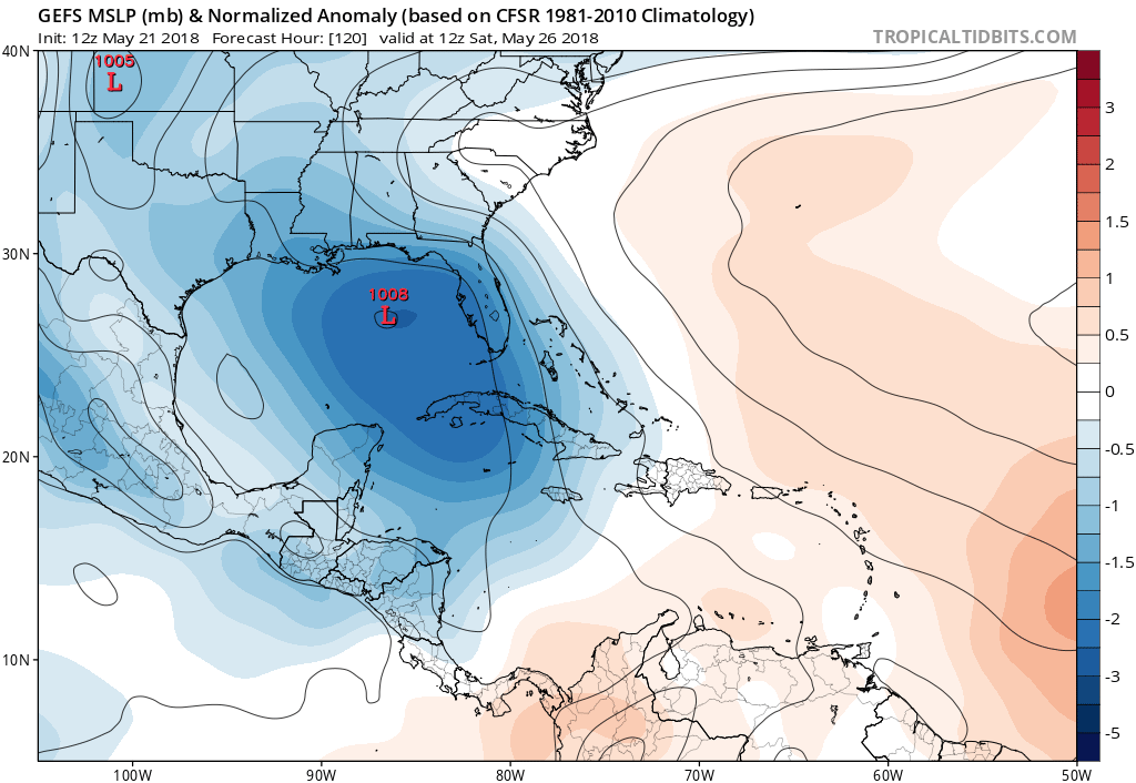
12Z GFS ensemble mean looks more uncertain into FL peninsula and the mean itself is quite a bit more west - caving to the Euro?
0 likes
-
cycloneye
- Admin
- Posts: 149372
- Age: 69
- Joined: Thu Oct 10, 2002 10:54 am
- Location: San Juan, Puerto Rico
Re: Western Caribbean Area of Interest
Alyono wrote:NEW TROPICAL CYCLONE FORECAST TO DEVELOP AFTER 120 HOURS
FORECAST POSITION AT T+120 : 19.8N 86.3W
LEAD CENTRAL MAXIMUM WIND
VERIFYING TIME TIME POSITION PRESSURE (MB) SPEED (KNOTS)
-------------- ---- -------- ------------- -------------
1200UTC 26.05.2018 120 19.8N 86.3W 1004 28
0000UTC 27.05.2018 132 21.4N 85.6W 1002 30
1200UTC 27.05.2018 144 24.3N 85.5W 999 41
Umm,UKMET is stronger.
0 likes
Visit the Caribbean-Central America Weather Thread where you can find at first post web cams,radars
and observations from Caribbean basin members Click Here
and observations from Caribbean basin members Click Here
-
toad strangler

- S2K Supporter
- Posts: 4546
- Joined: Sun Jul 28, 2013 3:09 pm
- Location: Earth
- Contact:
Re: Western Caribbean Area of Interest
gatorcane wrote:12Z GFS ensemble mean looks more uncertain into FL peninsula and the mean itself is quite a bit more west - caving to the Euro?
Most are clustered in the Big Bend area
0 likes
My Weather Station
https://www.wunderground.com/dashboard/pws/KFLPORTS603
https://www.wunderground.com/dashboard/pws/KFLPORTS603
-
Aric Dunn
- Category 5
- Posts: 21238
- Age: 43
- Joined: Sun Sep 19, 2004 9:58 pm
- Location: Ready for the Chase.
- Contact:
Re: Western Caribbean Area of Interest
just becasue..
00z euro simulated radar as it approaches coast and environment improves.

00z euro simulated radar as it approaches coast and environment improves.
0 likes
Note: If I make a post that is brief. Please refer back to previous posts for the analysis or reasoning. I do not re-write/qoute what my initial post said each time.
If there is nothing before... then just ask
Space & Atmospheric Physicist, Embry-Riddle Aeronautical University,
I believe the sky is falling...
If there is nothing before... then just ask
Space & Atmospheric Physicist, Embry-Riddle Aeronautical University,
I believe the sky is falling...
Who is online
Users browsing this forum: Google Adsense [Bot] and 83 guests