2018 Tropics: Global Model Runs Discussion (Out to day 16)
Moderator: S2k Moderators
Forum rules

The posts in this forum are NOT official forecasts and should not be used as such. They are just the opinion of the poster and may or may not be backed by sound meteorological data. They are NOT endorsed by any professional institution or STORM2K. For official information, please refer to products from the National Hurricane Center and National Weather Service.

Re: 2018 Tropics: Global Model Runs Discussion (Out to day 16)
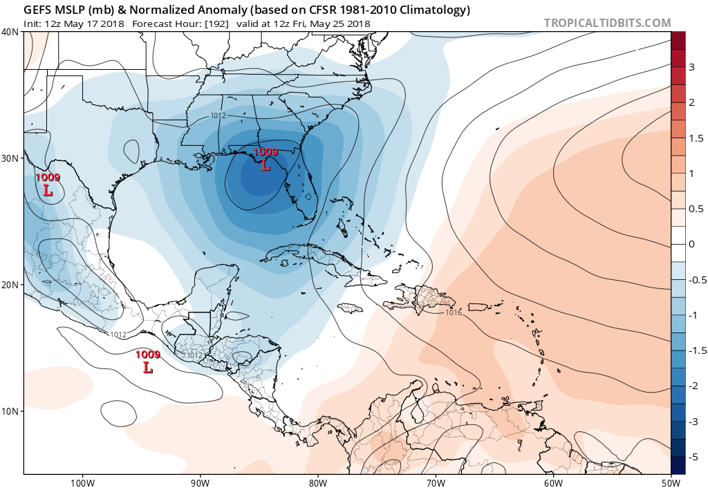
Canadian now favors a real TC on the EPAC side, leaving just a sheared mess in the Gulf
2 likes
-
cycloneye

- Admin

- Posts: 149338
- Age: 69
- Joined: Thu Oct 10, 2002 10:54 am
- Location: San Juan, Puerto Rico
Re: 2018 Tropics: Global Model Runs Discussion (Out to day 16)
Not so fast says Levi Cowan.
@TropicalTidbits
Just a reminder that the GFS has remarkable problems in large-scale cyclonic, convective environments. For example, the speed of northward propagation and amplification of the W. Carib low on the 12Z run is mostly a product of errant convection. These are the vorticity paintbombs
https://twitter.com/TropicalTidbits/status/997152308495552512
0 likes
Visit the Caribbean-Central America Weather Thread where you can find at first post web cams,radars
and observations from Caribbean basin members Click Here
and observations from Caribbean basin members Click Here
-
chris_fit

- Category 5

- Posts: 3261
- Age: 43
- Joined: Wed Sep 10, 2003 11:58 pm
- Location: Tampa Bay Area, FL
Re: 2018 Tropics: Global Model Runs Discussion (Out to day 16)
12Z GFS pretty much takes it up the spine of FL

0 likes

Re: 2018 Tropics: Global Model Runs Discussion (Out to day 16)
chris_fit wrote:12Z GFS pretty much takes it up the spine of FL
What I especially don't like is the fact that it looks like it's going to loop back into the Gulf for more trouble..
0 likes
-
chris_fit
- Category 5
- Posts: 3261
- Age: 43
- Joined: Wed Sep 10, 2003 11:58 pm
- Location: Tampa Bay Area, FL
Re: 2018 Tropics: Global Model Runs Discussion (Out to day 16)
Exalt wrote:What I especially don't like is the fact that it looks like it's going to loop back into the Gulf for more trouble..
Naaa - goes right up north
0 likes
Re: 2018 Tropics: Global Model Runs Discussion (Out to day 16)
chris_fit wrote:Exalt wrote:What I especially don't like is the fact that it looks like it's going to loop back into the Gulf for more trouble..
Naaa - goes right up north
Huh weird cause in the last frame the center is over the Gulf
0 likes
-
gatorcane

- S2K Supporter

- Posts: 23708
- Age: 48
- Joined: Sun Mar 13, 2005 3:54 pm
- Location: Boca Raton, FL
Re: 2018 Tropics: Global Model Runs Discussion (Out to day 16)
12Z GFS ensembles show good concentration around big bend area of Florida / NE Gulf and are mostly west of where the GFS operational has the system. What is it about the Big Bend of Florida? Seems early season cyclones love heading that way. That said, being a sheared system, heavy rainfall would extend well east of the center.
Last edited by gatorcane on Thu May 17, 2018 12:34 pm, edited 1 time in total.
1 likes
-
txwatcher91
- Category 5
- Posts: 1498
- Joined: Tue Aug 02, 2005 2:29 pm
Re: 2018 Tropics: Global Model Runs Discussion (Out to day 16)
wxman57 wrote:MGC wrote:weathaguyry wrote:The FV3-GFS is the new comedy section of tropical tidbits
It is.....06Z run has a 933mb cane on Louisiana coast on May 31st.....MGC
And it sits on the SE Louisiana coast for 2 days as a major hurricane, putting New Orleans underwater. This "upgraded" GFS is going to be interesting...
My fear is once we get an actual tropical storm to form, these FV3 GFS runs are going to be plastered all over social media for click bait and cause a lot of people to panic. The "new GFS" last year was bad enough, this FV3 "upgraded" version will be even worse.
FWIW the 12z ICON has a decent storm passing through the Yucatan channel.
2 likes
-
gatorcane
- S2K Supporter
- Posts: 23708
- Age: 48
- Joined: Sun Mar 13, 2005 3:54 pm
- Location: Boca Raton, FL
Re: 2018 Tropics: Global Model Runs Discussion (Out to day 16)
Time to open a new thread on the Western Caribbean system? Floater currently on NW Caribbean is being moved down to the SW Caribbean blob:
http://rammb.cira.colostate.edu/ramsdis ... display=12
http://rammb.cira.colostate.edu/ramsdis ... display=12
0 likes
-
cycloneye
- Admin
- Posts: 149338
- Age: 69
- Joined: Thu Oct 10, 2002 10:54 am
- Location: San Juan, Puerto Rico
Re: 2018 Tropics: Global Model Runs Discussion (Out to day 16)
We have a new thread for the SW Caribbean area so go there to post the models runs.Thanks for your cooperation.
viewtopic.php?f=31&t=119567&p=2674617#p2674617
viewtopic.php?f=31&t=119567&p=2674617#p2674617
0 likes
Visit the Caribbean-Central America Weather Thread where you can find at first post web cams,radars
and observations from Caribbean basin members Click Here
and observations from Caribbean basin members Click Here

Re: 2018 Tropics: Global Model Runs Discussion (Out to day 16)
Alyono wrote:Canadian now favors a real TC on the EPAC side, leaving just a sheared mess in the Gulf
The CMC has been forecasting a phantom storm on the EPAC side for days now.
1 likes
Re: 2018 Tropics: Global Model Runs Discussion (Out to day 16)
the new FV GFS buries it over Central America
Maybe its time NCEP and you know who starts listening to the research community when it comes to model development. This is the second time they went against the suggestions of the research community when choosing the new NCEP global model
Maybe its time NCEP and you know who starts listening to the research community when it comes to model development. This is the second time they went against the suggestions of the research community when choosing the new NCEP global model
1 likes
-
wxman57

- Moderator-Pro Met

- Posts: 23172
- Age: 68
- Joined: Sat Jun 21, 2003 8:06 pm
- Location: Houston, TX (southwest)
Re: 2018 Tropics: Global Model Runs Discussion (Out to day 16)
Alyono wrote:Canadian now favors a real TC on the EPAC side, leaving just a sheared mess in the Gulf
That might be more realistic.
0 likes
-
PSUHiker31
- Tropical Storm

- Posts: 114
- Joined: Tue Oct 03, 2017 2:36 pm
Re: 2018 Tropics: Global Model Runs Discussion (Out to day 16)
I'm entertained by how the FV3 is continually developing a micro TC in the far NE Gulf and is actually moving up the development with each run... About 42 hours or less away.
0 likes
-
northjaxpro

- S2K Supporter
- Posts: 8900
- Joined: Mon Sep 27, 2010 11:21 am
- Location: Jacksonville, FL
Re: 2018 Tropics: Global Model Runs Discussion (Out to day 16)
1 likes
NEVER, EVER SAY NEVER in the tropics and weather in general, and most importantly, with life itself!!
________________________________________________________________________________________
Fay 2008 Beryl 2012 Debby 2012 Colin 2016 Hermine 2016 Julia 2016 Matthew 2016 Irma 2017 Dorian 2019
________________________________________________________________________________________
Fay 2008 Beryl 2012 Debby 2012 Colin 2016 Hermine 2016 Julia 2016 Matthew 2016 Irma 2017 Dorian 2019
-
AJC3

- Admin
- Posts: 4153
- Age: 62
- Joined: Tue Aug 31, 2004 7:04 pm
- Location: Ballston Spa, New York
- Contact:
Re: 2018 Tropics: Global Model Runs Discussion (Out to day 16)
LarryWx wrote:The 12Z FV3 develops a very tiny 996 mb TS 75 miles offshore in the Apalachee Bay 5/21. That looks like still another phantom. The SSTs up there are not even warm enough for tropical development! I have a feeling this is going to be a looooong season of phantoms.
PSUHiker31 wrote:I'm entertained by how the FV3 is continually developing a micro TC in the far NE Gulf and is actually moving up the development with each run... About 42 hours or less away.
There's a pretty apparent (albeit weak) low level vort center just offshore Cedar Key moving northwest toward Apalachicola. So while the model guidance was overdone, it correctly sniffed "something" small out, reasonably close to the correct time frame, a good 5 days in advance. That's pretty impressive to me.
As a fellow met said to me a couple decades ago, "Sometimes it's not about exactly what the model is saying, but what it's trying to say instead".
6 likes
Re: 2018 Tropics: Global Model Runs Discussion (Out to day 16)
AJC3 wrote:LarryWx wrote:The 12Z FV3 develops a very tiny 996 mb TS 75 miles offshore in the Apalachee Bay 5/21. That looks like still another phantom. The SSTs up there are not even warm enough for tropical development! I have a feeling this is going to be a looooong season of phantoms.PSUHiker31 wrote:I'm entertained by how the FV3 is continually developing a micro TC in the far NE Gulf and is actually moving up the development with each run... About 42 hours or less away.
There's a pretty apparent (albeit weak) low level vort center just offshore Cedar Key moving northwest toward Apalachicola. So while the model guidance was overdone, it correctly sniffed "something" small out, reasonably close to the correct time frame, a good 5 days in advance. That's pretty impressive to me.
As a fellow met said to me a couple decades ago, "Sometimes it's not about exactly what the model is saying, but what it's trying to say instead".
I think I see the very weak vortex on radar. Maybe this means the FV3 will be similar to the CMC, which would mean sometimes sniffing out something that other models don't sniff out due to being "genesis happy" but also showing numerous fake geneses as well as correct geneses that are often strengthened too much.
2 likes
Personal Forecast Disclaimer:
The posts in this forum are NOT official forecasts and should not be used as such. They are just the opinion of the poster and may or may not be backed by sound meteorological data. They are NOT endorsed by any professional institution or storm2k.org. For official information, please refer to the NHC and NWS products.
The posts in this forum are NOT official forecasts and should not be used as such. They are just the opinion of the poster and may or may not be backed by sound meteorological data. They are NOT endorsed by any professional institution or storm2k.org. For official information, please refer to the NHC and NWS products.
Re: 2018 Tropics: Global Model Runs Discussion (Out to day 16)
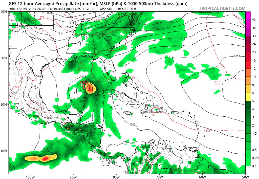
GFS keeps the monsoon trough over the Caribbean and cranks out another system around day 10
4 likes
-
gatorcane
- S2K Supporter
- Posts: 23708
- Age: 48
- Joined: Sun Mar 13, 2005 3:54 pm
- Location: Boca Raton, FL
Re: 2018 Tropics: Global Model Runs Discussion (Out to day 16)
Alyono wrote:GFS keeps the monsoon trough over the Caribbean and cranks out another system around day 10
Yep here it is:
0 likes


Re: 2018 Tropics: Global Model Runs Discussion (Out to day 16)
gatorcane wrote:Alyono wrote:GFS keeps the monsoon trough over the Caribbean and cranks out another system around day 10
Yep here it is:
It meanders it around Central Gulf before slamming the West Central Fl area.
Fantasy range but gives one the idea of the setup taking place then.
0 likes
Who is online
Users browsing this forum: AnnularCane, WaveBreaking and 95 guests