ATL: ALBERTO - Post-Tropical
Moderator: S2k Moderators
Re: ATL: INVEST 90L - Models
johngaltfla wrote:gatorcane wrote:Looks like the HWRF also shifted east closer to west coast of Florida. Things seem to be trending a bit toward the UKMET which is weaker and more east.
IMHO, last season the UKMET was much better on non-developed tropical systems than most models. I'll be curious to see if it verifies with this storm because it means the tweaks they made were superb and might make it the model to follow as systems start to develop.
UKMET also did superbly with Irma. It's a model I now give more credence too. But... Show me a center first before I trust anything
0 likes
Re: ATL: INVEST 90L - Models
Now that I finally gave in to pretty strong model consensus instead of putting too much emphasis on climo, the model based uncertainty increases. That figures. 
But that's what makes following the tropics so interesting...the unpredictability and surprises.
But that's what makes following the tropics so interesting...the unpredictability and surprises.
0 likes
Personal Forecast Disclaimer:
The posts in this forum are NOT official forecasts and should not be used as such. They are just the opinion of the poster and may or may not be backed by sound meteorological data. They are NOT endorsed by any professional institution or storm2k.org. For official information, please refer to the NHC and NWS products.
The posts in this forum are NOT official forecasts and should not be used as such. They are just the opinion of the poster and may or may not be backed by sound meteorological data. They are NOT endorsed by any professional institution or storm2k.org. For official information, please refer to the NHC and NWS products.
-
Twisted-core
Re: ATL: INVEST 90L - Models
0 likes
-
SouthFloridawx

- S2K Supporter

- Posts: 8346
- Age: 47
- Joined: Tue Jul 26, 2005 1:16 am
- Location: Sarasota, FL
- Contact:
Re: ATL: INVEST 90L - Discussion
Chances for rain have gone up 10% from yesterday. That beer is starting to smell good. 
SaturdayShowers and possibly a thunderstorm. Some of the storms could produce heavy rainfall. High near 81. Windy, with a southeast wind 15 to 21 mph, with gusts as high as 26 mph. Chance of precipitation is 80%.
Saturday NightShowers and possibly a thunderstorm. Some of the storms could produce heavy rainfall. Low around 76. Windy, with a southeast wind around 22 mph, with gusts as high as 29 mph. Chance of precipitation is 80%.
SundayShowers and possibly a thunderstorm. Some of the storms could produce heavy rainfall. High near 83. Windy, with a southeast wind 23 to 25 mph, with gusts as high as 33 mph. Chance of precipitation is 80%.
Sunday NightShowers likely and possibly a thunderstorm. Some of the storms could produce heavy rainfall. Cloudy, with a low around 76. Windy, with a south wind around 21 mph, with gusts as high as 26 mph. Chance of precipitation is 70%.
SouthFloridawx wrote:Done!boca wrote:SouthFloridawx wrote:How much?
I’ll bet a 6 pack of beer and this is for SE Florida not the Sarasota area.
2 likes
-
gatorcane

- S2K Supporter
- Posts: 23708
- Age: 48
- Joined: Sun Mar 13, 2005 3:54 pm
- Location: Boca Raton, FL
Re: ATL: INVEST 90L - Models
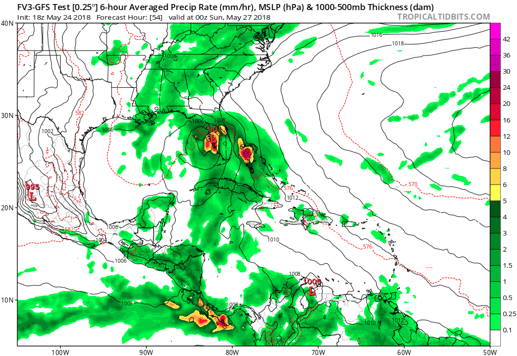
FV3 GFS same track as 12Z but more organized. Tampa gets a deluge.
0 likes

Re: ATL: INVEST 90L - Models
I'm a bit curious and suspicous of the UK motion being even further to the east. Tells me that the timing factor might play some role in the W. Atlantic ridge becoming a bit more eroded than most other models would indicate. Will be very curious to see if A) 0Z UK run continues to show a greater east motion over Florida, and B) Whether most other models begin to shift eastward as well. I dont see that extent of an NNE track but it might be some tip off regarding some mid to upper trough along the NE Conus potentially playing havoc with the present ridge in place
0 likes
Andy D
(For official information, please refer to the NHC and NWS products.)
(For official information, please refer to the NHC and NWS products.)
-
gfsperpendicular

- Category 1

- Posts: 383
- Age: 21
- Joined: Mon Jun 19, 2017 3:04 pm
- Location: Northern Virginia
Re: ATL: INVEST 90L - Discussion
The circulation looks more defined than at this time yesterday. Also it looks like there's a pretty good outflow over the convection to the north?
0 likes
I'm not sleeping, I'm waiting for the 0900 UTC advisory!
#1 CMC stan
#1 CMC stan
-
gfsperpendicular
- Category 1
- Posts: 383
- Age: 21
- Joined: Mon Jun 19, 2017 3:04 pm
- Location: Northern Virginia
Re: ATL: INVEST 90L - Models
chaser1 wrote:I'm a bit curious and suspicous of the UK motion being even further to the east. Tells me that the timing factor might play some role in the W. Atlantic ridge becoming a bit more eroded than most other models would indicate. Will be very curious to see if A) 0Z UK run continues to show a greater east motion over Florida, and B) Whether most other models begin to shift eastward as well. I dont see that extent of an NNE track but it might be some tip off regarding some mid to upper trough along the NE Conus potentially playing havoc with the present ridge in place
In the morning, the center of circ might be better defined and then the models might be able to come to a better consensus one way or the other.
0 likes
I'm not sleeping, I'm waiting for the 0900 UTC advisory!
#1 CMC stan
#1 CMC stan
-
Evil Jeremy

- S2K Supporter
- Posts: 5463
- Age: 32
- Joined: Mon Apr 10, 2006 2:10 pm
- Location: Los Angeles, CA
Re: ATL: INVEST 90L - Models
chaser1 wrote:I'm a bit curious and suspicous of the UK motion being even further to the east. Tells me that the timing factor might play some role in the W. Atlantic ridge becoming a bit more eroded than most other models would indicate. Will be very curious to see if A) 0Z UK run continues to show a greater east motion over Florida, and B) Whether most other models begin to shift eastward as well. I dont see that extent of an NNE track but it might be some tip off regarding some mid to upper trough along the NE Conus potentially playing havoc with the present ridge in place
From what I can tell, nearly everyone adjusted east (to some degree) during the 12z and 18z cycles. And here I was hoping a consensus was reached with today's 00z and 06z models that would hold. Very anxious to see what trend the 00z models will show. Impacts to Florida would start in about 48ish hours, depending on if 90L goes east or west.
0 likes
Frances 04 / Jeanne 04 / Katrina 05 / Wilma 05 / Fay 08 / Debby 12 / Andrea 13 / Colin 16 / Hermine 16 / Matthew 16 / Irma 17
-
TheAustinMan

- Category 5

- Posts: 1060
- Joined: Mon Jul 08, 2013 4:26 pm
- Location: Central TX / United States
Re: ATL: INVEST 90L - Discussion
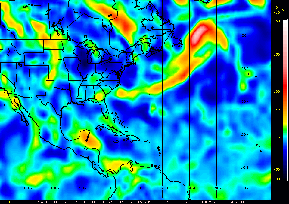
Throughout the day, the convection that has been generated by 90L has been continuously sheared off to the east-northeast by 20-50 kt wind shear. Att the lower levels a weak low has been spinning about all day on the Yucatan Peninsula, though some of the recent vorticity analyses have been suggesting that the circulation is being elongated towards the east and southeast. We'll see if another convective burst occurs this evening or tonight to refocus the storm's convective activity and wind flow. If the GFS and ECMWF/IFS are to be believed, a deeper circulation - in the middle and lower levels of the troposphere - should slowly foment over the Yucatan Channel over the next few days.
3.17 MB. Source: Generated by myself.

3.17 MB. Source: Generated by myself.
1 likes
Treat my opinions with a grain of salt. For official information see your local weather service.
“It's tough to make predictions, especially about the future.”
“It's tough to make predictions, especially about the future.”
Re: ATL: INVEST 90L - Models
gfsperpendicular wrote:chaser1 wrote:I'm a bit curious and suspicous of the UK motion being even further to the east. Tells me that the timing factor might play some role in the W. Atlantic ridge becoming a bit more eroded than most other models would indicate. Will be very curious to see if A) 0Z UK run continues to show a greater east motion over Florida, and B) Whether most other models begin to shift eastward as well. I dont see that extent of an NNE track but it might be some tip off regarding some mid to upper trough along the NE Conus potentially playing havoc with the present ridge in place
In the morning, the center of circ might be better defined and then the models might be able to come to a better consensus one way or the other.
I'm still seeing a pretty slow evolution and not thinking we'll yet see a significantly improved COC by morning, but think that we should begin to see improved structural improvement by late tomm. or Sat.
Convection has certainly become more healthy today (albeit sheared)
0 likes
Andy D
(For official information, please refer to the NHC and NWS products.)
(For official information, please refer to the NHC and NWS products.)
-
cycloneye

- Admin

- Posts: 149394
- Age: 69
- Joined: Thu Oct 10, 2002 10:54 am
- Location: San Juan, Puerto Rico
Re: ATL: INVEST 90L - Discussion
00z Best Track:
Location: 19.5°N 88.0°W
Maximum Winds: 30 kt Gusts: N/A
Minimum Central Pressure: 1009 mb
Environmental Pressure: 1013 mb
Radius of Circulation: 200 NM
Radius of Maximum Wind: 100 NM

Location: 19.5°N 88.0°W
Maximum Winds: 30 kt Gusts: N/A
Minimum Central Pressure: 1009 mb
Environmental Pressure: 1013 mb
Radius of Circulation: 200 NM
Radius of Maximum Wind: 100 NM
0 likes
Visit the Caribbean-Central America Weather Thread where you can find at first post web cams,radars
and observations from Caribbean basin members Click Here
and observations from Caribbean basin members Click Here
-
gatorcane
- S2K Supporter
- Posts: 23708
- Age: 48
- Joined: Sun Mar 13, 2005 3:54 pm
- Location: Boca Raton, FL
Re: ATL: INVEST 90L - Models
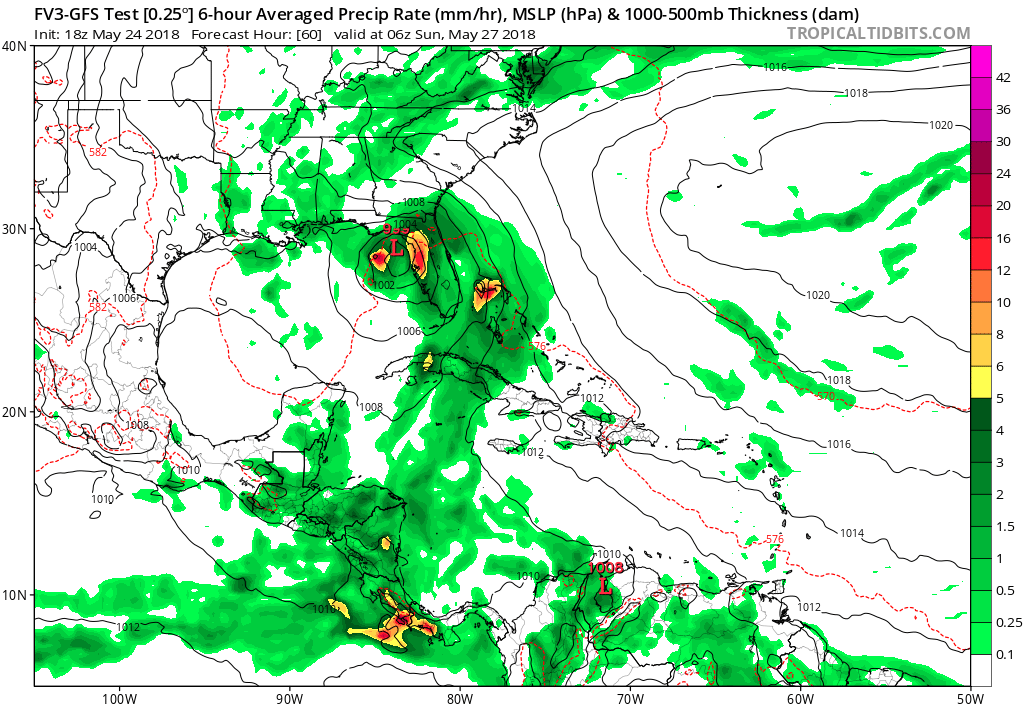
Another look at the FV3 GFS. The model can redeem itself if it ends up taking this track. Looks like it is about on top of a Tampa at 54 hours.
0 likes
-
Evil Jeremy
- S2K Supporter
- Posts: 5463
- Age: 32
- Joined: Mon Apr 10, 2006 2:10 pm
- Location: Los Angeles, CA
Re: ATL: INVEST 90L - Models
gatorcane wrote:Another look at the FV3 GFS. The model can redeem itself if it ends up taking this track. Looks like it is about on top of a Tampa at 54 hours.
https://s7.postimg.cc/x8tvnndqj/fv3p_ms ... watl_9.png
Every model suite that goes by, 6 (or 12) hours at a time, especially entering the 48 hour range, the more probable that the models hone in on a general solution. From the perspective of the Florida peninsula, I'm not enjoying the 12z and 18z models today. I'm not sure the models have more flips left in them. Then again, it alleviates a flood threat to the Central Gulf Coast.
1 likes
Frances 04 / Jeanne 04 / Katrina 05 / Wilma 05 / Fay 08 / Debby 12 / Andrea 13 / Colin 16 / Hermine 16 / Matthew 16 / Irma 17
-
AdamFirst

- S2K Supporter
- Posts: 2490
- Age: 36
- Joined: Thu Aug 14, 2008 10:54 am
- Location: Port Saint Lucie, FL
Re: ATL: INVEST 90L - Discussion
SouthFloridawx wrote:Chances for rain have gone up 10% from yesterday. That beer is starting to smell good.
The setup was supposed to be rainy for peninsular Florida even if the center was hundreds of miles away. I'd get yourself a 6 pack of some fancy IPA or something like that
0 likes
Dolphins Marlins Canes Golden Panthers HEAT
Andrew 1992 - Irene 1999 - Frances 2004 - Jeanne 2004 - Wilma 2005 - Fay 2008 - Isaac 2012 - Matthew 2016 - Irma 2017 - Dorian 2019 - Ian 2022 - Nicole 2022 - Milton 2024
Andrew 1992 - Irene 1999 - Frances 2004 - Jeanne 2004 - Wilma 2005 - Fay 2008 - Isaac 2012 - Matthew 2016 - Irma 2017 - Dorian 2019 - Ian 2022 - Nicole 2022 - Milton 2024
-
gatorcane
- S2K Supporter
- Posts: 23708
- Age: 48
- Joined: Sun Mar 13, 2005 3:54 pm
- Location: Boca Raton, FL
Re: ATL: INVEST 90L - Discussion
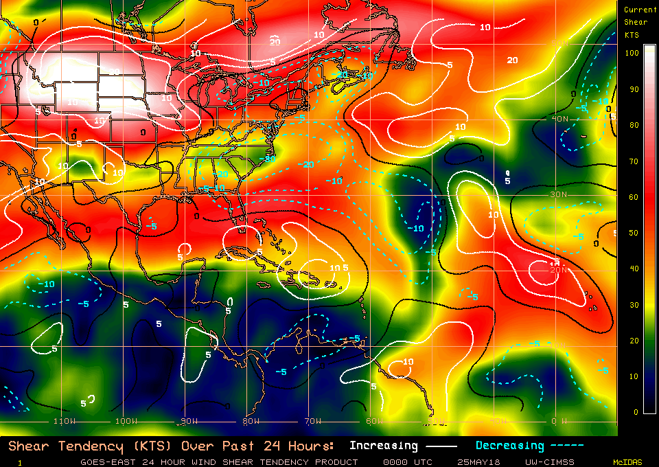
Shear is increasing some again over the Gulf. Maybe this is why the 18Z guidance is backing off some on how organized 90l gets. That is quite a wall of shear, let’s see what the 00Z guidance shows.
0 likes

-
AdamFirst
- S2K Supporter
- Posts: 2490
- Age: 36
- Joined: Thu Aug 14, 2008 10:54 am
- Location: Port Saint Lucie, FL
Re: ATL: INVEST 90L - Discussion
boca wrote:Even if I lose the bet it’s beer so to me it’s all good.
Might as well knock back some cold ones as we're rained in
Burgers on a stovetop or griddle can be just as good as they are off a grill
1 likes
Dolphins Marlins Canes Golden Panthers HEAT
Andrew 1992 - Irene 1999 - Frances 2004 - Jeanne 2004 - Wilma 2005 - Fay 2008 - Isaac 2012 - Matthew 2016 - Irma 2017 - Dorian 2019 - Ian 2022 - Nicole 2022 - Milton 2024
Andrew 1992 - Irene 1999 - Frances 2004 - Jeanne 2004 - Wilma 2005 - Fay 2008 - Isaac 2012 - Matthew 2016 - Irma 2017 - Dorian 2019 - Ian 2022 - Nicole 2022 - Milton 2024

Re: ATL: INVEST 90L - Discussion
I don't see more than about 5knots of shear, what am I missing ?
1 likes
Who is online
Users browsing this forum: No registered users and 21 guests