ATL: ALBERTO - Post-Tropical

Moderator: S2k Moderators

Message
Author
txwatcher91
Category 5
Category 5
Posts: 1498
Joined: Tue Aug 02, 2005 2:29 pm

Re: ATL: INVEST 90L - Models

#841 Postby txwatcher91 » Thu May 24, 2018 10:01 pm

3km nam is a monster. Likely overdone but here it is...

Image

Image
1 likes   

SunnyThoughts
Category 5
Category 5
Posts: 2263
Joined: Wed Jul 09, 2003 12:42 pm
Location: Pensacola, Florida

Re: ATL: INVEST 90L - Models

#842 Postby SunnyThoughts » Thu May 24, 2018 10:05 pm

I certainly hope that is in no way an indication of the rest of the model runs this evening.

And thanks Adam for answering my question earlier.
1 likes   

User avatar
toad strangler
S2K Supporter
S2K Supporter
Posts: 4543
Joined: Sun Jul 28, 2013 3:09 pm
Location: Earth
Contact:

Re: ATL: INVEST 90L - Models

#843 Postby toad strangler » Thu May 24, 2018 10:07 pm

txwatcher91 wrote:3km nam is a monster. Likely overdone but here it is...


LOL
0 likes   

Aric Dunn
Category 5
Category 5
Posts: 21238
Age: 42
Joined: Sun Sep 19, 2004 9:58 pm
Location: Ready for the Chase.
Contact:

Re: ATL: INVEST 90L - Models

#844 Postby Aric Dunn » Thu May 24, 2018 10:08 pm

well lets see if everything follows suit with the NAM again.. hurricane into NO..
0 likes   
Note: If I make a post that is brief. Please refer back to previous posts for the analysis or reasoning. I do not re-write/qoute what my initial post said each time.
If there is nothing before... then just ask :)

Space & Atmospheric Physicist, Embry-Riddle Aeronautical University,
I believe the sky is falling...

Aric Dunn
Category 5
Category 5
Posts: 21238
Age: 42
Joined: Sun Sep 19, 2004 9:58 pm
Location: Ready for the Chase.
Contact:

Re: ATL: INVEST 90L - Models

#845 Postby Aric Dunn » Thu May 24, 2018 10:10 pm

if that upper trough cuts off like it is forecast too.. we could see minimal hurricane.. not a cat 4 lol. but the Synoptics from the NAM are very interesting.
0 likes   
Note: If I make a post that is brief. Please refer back to previous posts for the analysis or reasoning. I do not re-write/qoute what my initial post said each time.
If there is nothing before... then just ask :)

Space & Atmospheric Physicist, Embry-Riddle Aeronautical University,
I believe the sky is falling...

Aric Dunn
Category 5
Category 5
Posts: 21238
Age: 42
Joined: Sun Sep 19, 2004 9:58 pm
Location: Ready for the Chase.
Contact:

Re: ATL: INVEST 90L - Models

#846 Postby Aric Dunn » Thu May 24, 2018 10:13 pm

ICON similar to the last 2 runs of it. the stronger ridging again seems to have little effect.
0 likes   
Note: If I make a post that is brief. Please refer back to previous posts for the analysis or reasoning. I do not re-write/qoute what my initial post said each time.
If there is nothing before... then just ask :)

Space & Atmospheric Physicist, Embry-Riddle Aeronautical University,
I believe the sky is falling...

txwatcher91
Category 5
Category 5
Posts: 1498
Joined: Tue Aug 02, 2005 2:29 pm

Re: ATL: INVEST 90L - Models

#847 Postby txwatcher91 » Thu May 24, 2018 10:15 pm

Aric Dunn wrote:if that upper trough cuts off like it is forecast too.. we could see minimal hurricane.. not a cat 4 lol. but the Synoptics from the NAM are very interesting.

I’m a bit concerned now regarding intensity. We’ve seen the Euro gradually showing s stronger storm, NAM a strong one and GFS earlier today as well. Most models intensify this right up to landfall and down to 980-985mb range. With the warm loop current it will likely pass over... I can see a sub 970mb pressure if the LLC consolidates the next 24 hours over the open waters.
0 likes   

User avatar
NotSparta
Professional-Met
Professional-Met
Posts: 1670
Age: 23
Joined: Fri Aug 18, 2017 8:24 am
Location: Naples, FL
Contact:

Re: ATL: INVEST 90L - Discussion

#848 Postby NotSparta » Thu May 24, 2018 10:16 pm

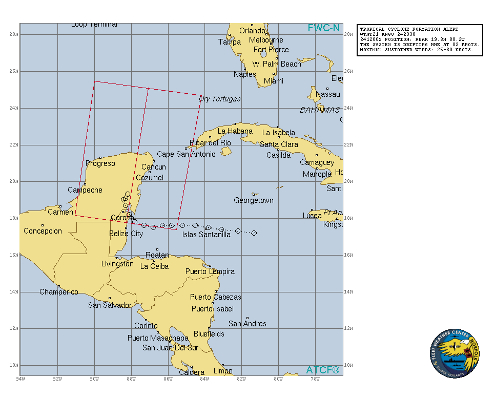
TCFA issued.

WTNT21 KNGU 242330
SUBJ/TROPICAL CYCLONE FORMATION ALERT//
RMKS/1. FORMATION OF A SIGNIFICANT TROPICAL CYCLONE IS POSSIBLE
WITHIN 160 NM EITHER SIDE OF A LINE FROM 17.7N 88.2W TO 25.1N 87.0W
WITHIN THE NEXT 24 HOURS. AVAILABLE DATA DOES NOT JUSTIFY ISSUANCE
OF NUMBERED TROPICAL CYCLONE WARNINGS AT THIS TIME. WINDS IN THE
AREA ARE ESTIMATED TO BE 30 KNOTS. METSAT IMAGERY AT 242000Z
INDICATES THAT A CIRCULATION CENTER IS LOCATED NEAR 19.3N 88.2W. THE
SYSTEM IS DRIFTING NORTH-NORTHEASTWARD AT 02 KNOTS.
2. REMARKS: A LOW PRESSURE SYSTEM LOCATED INLAND OVER THE EASTERN
PORTION OF THE YUCATAN PENINSULA IS GRADUALLY BECOMING BETTER
DEFINED. THE SYSTEM IS PRODUCING A DISORGANIZED AREA OF SHOWERS AND
THUNDERSTORMS OVER THE NORTHWESTERN CARIBBEAN AND YUCATAN CHANNEL
WITH WINDS OF 30 KTS. ENVIRONMENTAL CONDITIONS ARE EXPECTED TO
BECOME MORE FAVORABLE FOR DEVELOPEMENT FRIDAY AND SATURDAY AND A
SUBTROPICAL OR TROPICAL CYCLONE IS LIKELY TO FORM WHILE THE LOW
MOVES INTO THE SOUTHERN GULF OF MEXICO.
3. THIS ALERT WILL BE REISSUED, UPGRADED TO WARNING OR CANCELLED BY
252330Z.//

Image
1 likes   
This post was probably an opinion of mine, and in no way is official. Please refer to http://www.hurricanes.gov for official tropical analysis and advisories.

My website, with lots of tropical wx graphics, including satellite and recon: http://cyclonicwx.com

User avatar
Bocadude85
Category 5
Category 5
Posts: 2991
Age: 38
Joined: Mon Apr 18, 2005 2:20 pm
Location: Honolulu,Hi

Re: ATL: INVEST 90L - Models

#849 Postby Bocadude85 » Thu May 24, 2018 10:18 pm

Aric Dunn wrote:ICON similar to the last 2 runs of it. the stronger ridging again seems to have little effect.


ICON seems to be a bit farther east then the 18z from what I can see, but I can only see up to the 69 hour point.
0 likes   

Aric Dunn
Category 5
Category 5
Posts: 21238
Age: 42
Joined: Sun Sep 19, 2004 9:58 pm
Location: Ready for the Chase.
Contact:

Re: ATL: INVEST 90L - Models

#850 Postby Aric Dunn » Thu May 24, 2018 10:19 pm

txwatcher91 wrote:
Aric Dunn wrote:if that upper trough cuts off like it is forecast too.. we could see minimal hurricane.. not a cat 4 lol. but the Synoptics from the NAM are very interesting.


I’m a bit concerned now regarding intensity. We’ve seen the Euro gradually showing s stronger storm, NAM a strong one and GFS earlier today as well. Most models intensify this right up to landfall and down to 980-985mb range. With the warm loop current it will likely pass over... I can see a sub 970mb pressure if the LLC consolidates the next 24 hours over the open waters.

I mean at least right now.. the idea of it being in that "sweet Spot" is looking like a possibility. but a lot still has to come together for that to happen. namely the upper trough if it does not cut off then we will have a sheared mess the entire time and maybe a 50 to 60 mph TS. only time will tell. as that upper trough evolves we will know more.. so watch the upper water vapor !
0 likes   
Note: If I make a post that is brief. Please refer back to previous posts for the analysis or reasoning. I do not re-write/qoute what my initial post said each time.
If there is nothing before... then just ask :)

Space & Atmospheric Physicist, Embry-Riddle Aeronautical University,
I believe the sky is falling...

User avatar
toad strangler
S2K Supporter
S2K Supporter
Posts: 4543
Joined: Sun Jul 28, 2013 3:09 pm
Location: Earth
Contact:

Re: ATL: INVEST 90L - Models

#851 Postby toad strangler » Thu May 24, 2018 10:19 pm

txwatcher91 wrote:
Aric Dunn wrote:if that upper trough cuts off like it is forecast too.. we could see minimal hurricane.. not a cat 4 lol. but the Synoptics from the NAM are very interesting.


I’m a bit concerned now regarding intensity. We’ve seen the Euro gradually showing s stronger storm, NAM a strong one and GFS earlier today as well. Most models intensify this right up to landfall and down to 980-985mb range. With the warm loop current it will likely pass over... I can see a sub 970mb pressure if the LLC consolidates the next 24 hours over the open waters.


It’s times like these that you trust climo. Modeling has always struggled mightily with intensity
0 likes   

User avatar
latitude_20
Tropical Storm
Tropical Storm
Posts: 196
Joined: Wed Jun 30, 2010 6:46 am
Location: Tulum, Mexico
Contact:

Re: ATL: INVEST 90L - Discussion: Tropical Cyclone Formation Alert issued

#852 Postby latitude_20 » Thu May 24, 2018 10:20 pm

Tulum, Mexico reporting in. Very rainy morning. Cloudy and humid throughout the day today, thundershowers just picked back up in the last two hours. The tree frogs are going bananas in the jungle next to me.

Buenas Noches,
Lat 20 out
8 likes   

User avatar
AdamFirst
S2K Supporter
S2K Supporter
Posts: 2491
Age: 36
Joined: Thu Aug 14, 2008 10:54 am
Location: Port Saint Lucie, FL

Re: ATL: INVEST 90L - Models

#853 Postby AdamFirst » Thu May 24, 2018 10:23 pm

A question: This is the first I've seen of the ICON model. Is this a new one entirely, or a rename? And can it be trusted for tropical weather?
0 likes   
Dolphins Marlins Canes Golden Panthers HEAT
Andrew 1992 - Irene 1999 - Frances 2004 - Jeanne 2004 - Wilma 2005 - Fay 2008 - Isaac 2012 - Matthew 2016 - Irma 2017 - Dorian 2019 - Ian 2022 - Nicole 2022 - Milton 2024

txwatcher91
Category 5
Category 5
Posts: 1498
Joined: Tue Aug 02, 2005 2:29 pm

Re: ATL: INVEST 90L - Models

#854 Postby txwatcher91 » Thu May 24, 2018 10:35 pm

toad strangler wrote:
txwatcher91 wrote:
Aric Dunn wrote:if that upper trough cuts off like it is forecast too.. we could see minimal hurricane.. not a cat 4 lol. but the Synoptics from the NAM are very interesting.


I’m a bit concerned now regarding intensity. We’ve seen the Euro gradually showing s stronger storm, NAM a strong one and GFS earlier today as well. Most models intensify this right up to landfall and down to 980-985mb range. With the warm loop current it will likely pass over... I can see a sub 970mb pressure if the LLC consolidates the next 24 hours over the open waters.


It’s times like these that you trust climo. Modeling has always struggled mightily with intensity


But climo is not always right. No one thought we would have so many cat 5 hurricanes last year but we did... when the Euro and Nam both show a period of steady to quick deepening it catches my eye. GFS is rolling let’s see what it does.
1 likes   

Dean4Storms
S2K Supporter
S2K Supporter
Posts: 6358
Age: 62
Joined: Sun Aug 31, 2003 1:01 pm
Location: Miramar Bch. FL

Re: ATL: INVEST 90L - Models

#855 Postby Dean4Storms » Thu May 24, 2018 10:36 pm

Not liking this intensity trend one bit by some of these models.
0 likes   

User avatar
toad strangler
S2K Supporter
S2K Supporter
Posts: 4543
Joined: Sun Jul 28, 2013 3:09 pm
Location: Earth
Contact:

Re: ATL: INVEST 90L - Models

#856 Postby toad strangler » Thu May 24, 2018 10:37 pm

txwatcher91 wrote:
toad strangler wrote:
txwatcher91 wrote:
I’m a bit concerned now regarding intensity. We’ve seen the Euro gradually showing s stronger storm, NAM a strong one and GFS earlier today as well. Most models intensify this right up to landfall and down to 980-985mb range. With the warm loop current it will likely pass over... I can see a sub 970mb pressure if the LLC consolidates the next 24 hours over the open waters.

It’s times like these that you trust climo. Modeling has always struggled mightily with intensity


But climo is not always right. No one thought we would have so many cat 5 hurricanes last year but we did... when the Euro and Nam both show a period of steady to quick deepening it catches my eye. GFS is rolling let’s see what it does.


We are talking about MAY climo. Not SEPTEMBER climo. Gigantic difference.
Last edited by toad strangler on Thu May 24, 2018 10:38 pm, edited 1 time in total.
0 likes   

txwatcher91
Category 5
Category 5
Posts: 1498
Joined: Tue Aug 02, 2005 2:29 pm

Re: ATL: INVEST 90L - Models

#857 Postby txwatcher91 » Thu May 24, 2018 10:37 pm

AdamFirst wrote:A question: This is the first I've seen of the ICON model. Is this a new one entirely, or a rename? And can it be trusted for tropical weather?


It’s the German model. I’ve followed it a few years for winter storms and it is hit or miss. Sometimes it is brilliant and other times it can be the worst model... For tropical weather the little bit I’ve followed it I’ve not been impressed with it. I much prefer NAM, Euro and GFS blend inside 84 hours.
0 likes   

SunnyThoughts
Category 5
Category 5
Posts: 2263
Joined: Wed Jul 09, 2003 12:42 pm
Location: Pensacola, Florida

Re: ATL: INVEST 90L - Models

#858 Postby SunnyThoughts » Thu May 24, 2018 10:37 pm

And the Icon heads the system towards Louisiana, then does a loop and goes back East into Mobile Bay? heh
0 likes   

txwatcher91
Category 5
Category 5
Posts: 1498
Joined: Tue Aug 02, 2005 2:29 pm

Re: ATL: INVEST 90L - Models

#859 Postby txwatcher91 » Thu May 24, 2018 10:42 pm

toad strangler wrote:
txwatcher91 wrote:
toad strangler wrote:It’s times like these that you trust climo. Modeling has always struggled mightily with intensity


But climo is not always right. No one thought we would have so many cat 5 hurricanes last year but we did... when the Euro and Nam both show a period of steady to quick deepening it catches my eye. GFS is rolling let’s see what it does.


We are talking about MAY climo. Not SEPTEMBER clomp. Gigantic difference.


It doesn’t matter, September climo doesn’t favor multiple cat 5s but it happened. Point is the models are tools and to be used as such. The Euro and NAM showing a storm that deepens quickly up until landfall, possibly sub 980mb, is worth considering as a possibility. The shear charts show an anticyclone developing providing nice outflow and reducing shear dramatically. The loop current is plenty warm at 27-29C as well. May climo says there should be 50kts of shear to rip this apart but if modeling is correct it will be very low and favor steady intensification...

Image
Last edited by txwatcher91 on Thu May 24, 2018 10:43 pm, edited 1 time in total.
2 likes   

Alyono
Professional-Met
Professional-Met
Posts: 6961
Joined: Fri Apr 26, 2013 3:52 pm
Location: Texas Coast

Re: ATL: INVEST 90L - Models

#860 Postby Alyono » Thu May 24, 2018 10:42 pm

txwatcher91 wrote:
Aric Dunn wrote:if that upper trough cuts off like it is forecast too.. we could see minimal hurricane.. not a cat 4 lol. but the Synoptics from the NAM are very interesting.


I’m a bit concerned now regarding intensity. We’ve seen the Euro gradually showing s stronger storm, NAM a strong one and GFS earlier today as well. Most models intensify this right up to landfall and down to 980-985mb range. With the warm loop current it will likely pass over... I can see a sub 970mb pressure if the LLC consolidates the next 24 hours over the open waters.


parallel euro, which should be operational in a couple of weeks, only had about 996mb
0 likes   


Return to “2018”

Who is online

Users browsing this forum: No registered users and 4 guests