Fantastic view from GOES-16.
@NOAASatellitePA
UPDATE: NOAA's #GOES16 (#GOESEast) continues to closely monitor Subtropical Storm #Alberto this morning, May 25, 2018. This is the first, named #storm GOES-16 has captured as an officially operational satellite.
https://twitter.com/NOAASatellitePA/status/1000039344059625477
ATL: ALBERTO - Post-Tropical
Moderator: S2k Moderators
-
cycloneye

- Admin

- Posts: 149400
- Age: 69
- Joined: Thu Oct 10, 2002 10:54 am
- Location: San Juan, Puerto Rico
Re: ATL: ALBERTO - Sub-Tropical Storm
3 likes
Visit the Caribbean-Central America Weather Thread where you can find at first post web cams,radars
and observations from Caribbean basin members Click Here
and observations from Caribbean basin members Click Here
-
Frank P
- S2K Supporter

- Posts: 2779
- Joined: Fri Aug 29, 2003 10:52 am
- Location: Biloxi Beach, Ms
- Contact:
Re: ATL: ALBERTO - Models
GFS 983mb at NOLA in 90 hours, then bumps a tad to the NE to hit the MS Coast... a little Friday afternoon lagniappe for all the Who Dat fans... 
Last edited by Frank P on Fri May 25, 2018 11:08 am, edited 1 time in total.
1 likes
-
Aric Dunn
- Category 5

- Posts: 21238
- Age: 43
- Joined: Sun Sep 19, 2004 9:58 pm
- Location: Ready for the Chase.
- Contact:
Re: ATL: ALBERTO - Models
GFS 982mb in NOLA... very likely a hurricane at that point.
0 likes
Note: If I make a post that is brief. Please refer back to previous posts for the analysis or reasoning. I do not re-write/qoute what my initial post said each time.
If there is nothing before... then just ask
Space & Atmospheric Physicist, Embry-Riddle Aeronautical University,
I believe the sky is falling...
If there is nothing before... then just ask
Space & Atmospheric Physicist, Embry-Riddle Aeronautical University,
I believe the sky is falling...


-
txwatcher91
- Category 5
- Posts: 1498
- Joined: Tue Aug 02, 2005 2:29 pm
ATL: ALBERTO - Sub-Tropical Storm
Something I haven't seen much discussion of but certainly worth noting is the fairly large wind field models are indicating with Alberto. Here at landfall the GFS is indicating a strong TS or minimal hurricane with a large area of TS force winds. An area of TS winds like this would push a good bit of water up into the surge prone areas along the coast.

0 likes
-
gatorcane

- S2K Supporter
- Posts: 23708
- Age: 48
- Joined: Sun Mar 13, 2005 3:54 pm
- Location: Boca Raton, FL
Re: ATL: ALBERTO - Models
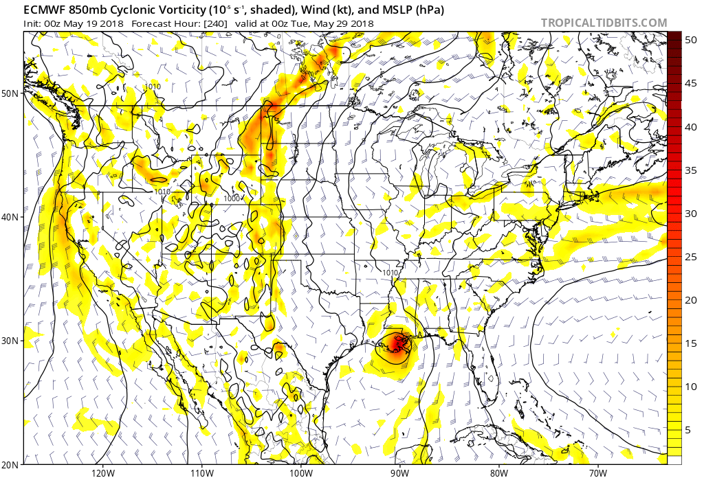
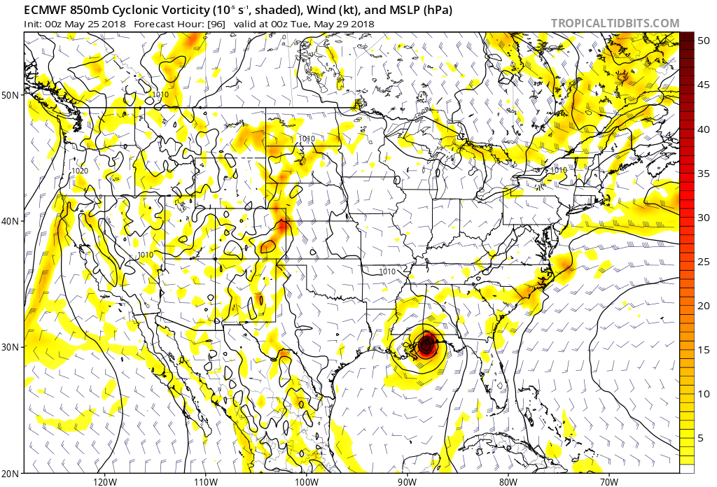
OK so I have to give props to the ECMWF here. Look at where it had the system on the 00Z run on May 19th (first image, yes 5 days ago!) compared to what it is showing today on the last 00Z run. The model accuracy can be incredibly impressive, another coupe for the ECMWF and its ensembles.
3 likes
-
flamingosun

- S2K Supporter
- Posts: 197
- Joined: Wed Sep 15, 2004 4:51 am
- Location: Merritt Island, FL
Re: ATL: Breaking News: NHC will initiate advisories on Subtropical Storm Alberto at 11 AM EDT
Patrick99 wrote:chaser1 wrote:Hmmm? Jump straight to T.S.? Must be a holiday week-end lol! (That, or a lot of really pissed off and seasick passengers on that Carnival ship!)
It has probably been quite the few hours for those passengers. I've been on large cruise ships in rough seas, and they start to rock and roll pretty significantly. I tend to enjoy when that happens, as it really rocks me to sleep in a way that just can never happen on land. I also enjoy watching the top deck pools violently slosh back and forth. Some people really can't handle the movement well, though.
I guess the NHC had a good deal of respect for that ship report after all.
I don't know about Carnival Cruise Line, but Royal Caribbean Cruises has its own Chief Meteorologist.
Rerouting multiple ships to calmer seas and open ports that are out of danger is no small task... With multiple ships per line, and hundreds to thousands of crew and passengers per ship, and lists of port closures changing with the progress of a storm as well as safe passage to those ports, well it has to be quite a logistical challenge.
Passenger ships really need reliable weather instruments to stay abreast of the latest and most accurate information possible. I don't think it's considered an option.
Last edited by flamingosun on Fri May 25, 2018 11:43 am, edited 3 times in total.
2 likes
-
cycloneye
- Admin
- Posts: 149400
- Age: 69
- Joined: Thu Oct 10, 2002 10:54 am
- Location: San Juan, Puerto Rico
Re: ATL: ALBERTO - Models
JB's take on GFS:
@BigJoeBastardi
Amazing watching the GFS from an amusement point of view run after run of feedback fairy problems into s FLA, now is FURTHER WEST than euro which has always aimed at central gulf coast. It is seeing our worry about intensification tho, now down to 987 Busy weekend
@BigJoeBastardi
Amazing watching the GFS from an amusement point of view run after run of feedback fairy problems into s FLA, now is FURTHER WEST than euro which has always aimed at central gulf coast. It is seeing our worry about intensification tho, now down to 987 Busy weekend
1 likes
Visit the Caribbean-Central America Weather Thread where you can find at first post web cams,radars
and observations from Caribbean basin members Click Here
and observations from Caribbean basin members Click Here

Re: ATL: ALBERTO - Sub-Tropical Storm
txwatcher91 wrote:Something I haven't seen much discussion of but certainly worth noting is the fairly large wind field models are indicating with Alberto. Here at landfall the GFS is indicating a strong TS or minimal hurricane with a large area of TS force winds. An area of TS winds like this would push a good bit of water up into the surge prone areas along the coast.
You are correct about that. Even a strong tropical storm would likely bring enough surge to require warnings east of the center.
1 likes
-
Florida1118
Re: ATL: ALBERTO - Models
Aric Dunn wrote:NDG wrote:Another westward shift by the GFS, now just south of the mouth of the MS River by hr 66.
Amazing what happens when the feed back issues go away lol
The issue definitely didn't go away, they're pretty evident hr 36 and hr 42.
0 likes
-
bamajammer4eva
- Category 4

- Posts: 907
- Joined: Sun Apr 18, 2010 3:21 am
- Location: Ozark, AL
Re: ATL: ALBERTO - Models
Double Barrel Low At hr 42 and it picks the more NW center. would it likely really have 2 centers after being a system for 2 days?

1 likes
-
Frank P
- S2K Supporter
- Posts: 2779
- Joined: Fri Aug 29, 2003 10:52 am
- Location: Biloxi Beach, Ms
- Contact:
Re: ATL: ALBERTO - Models
The GFS is now basically where the Euro was aiming at consistently several days ago... and although the last day of Euro runs were a slight shift towards the MS/AL line... gotta give the Euro cudos for at least being in the same ballpark all week long... thus far...
1 likes
-
cycloneye
- Admin
- Posts: 149400
- Age: 69
- Joined: Thu Oct 10, 2002 10:54 am
- Location: San Juan, Puerto Rico
Re: ATL: ALBERTO - Sub-Tropical Storm
@TropicalTidbits
North of #Alberto's low-level center, mid-level westerly flow exists, suggesting that the mid-level center is somewhere near the convection to the NE. This may foreshadow a center-jump later.
Practically, this is expected, and is just the next step in the storm's organization.
https://twitter.com/TropicalTidbits/status/1000025626693324800
0 likes
Visit the Caribbean-Central America Weather Thread where you can find at first post web cams,radars
and observations from Caribbean basin members Click Here
and observations from Caribbean basin members Click Here
Re: ATL: ALBERTO - Models
Florida1118 wrote:Aric Dunn wrote:NDG wrote:Another westward shift by the GFS, now just south of the mouth of the MS River by hr 66.
Amazing what happens when the feed back issues go away lol
The issue definitely didn't go away, they're pretty evident hr 36 and hr 42.
The difference during the past couple of runs is that it keeps a stronger circulation with a couple of vortices rotating around it until windshear subsides after 36 hrs and the system becomes more organized, that is a lot more believable.
1 likes
Re: ATL: ALBERTO - Sub-Tropical Storm
cycloneye wrote:@TropicalTidbits
North of #Alberto's low-level center, mid-level westerly flow exists, suggesting that the mid-level center is somewhere near the convection to the NE. This may foreshadow a center-jump later.
Practically, this is expected, and is just the next step in the storm's organization.
https://twitter.com/TropicalTidbits/status/1000025626693324800
Would that mean more shifts East or have the models accounted for that happening?
0 likes

Re: ATL: ALBERTO - Models
Frank P wrote:The GFS is now basically where the Euro was aiming at consistently several days ago... and although the last day of Euro runs were a slight shift towards the MS/AL line... gotta give the Euro cudos for at least being in the same ballpark all week long... thus far...
Euro has been WAY more consistent than the jacked up GFS of late. Yep kudos..
2 likes
-
tarheelprogrammer

- S2K Supporter
- Posts: 1793
- Joined: Mon Mar 28, 2016 9:25 pm
- Location: Raleigh, NC area (Garner, NC)
Re: ATL: ALBERTO - Sub-Tropical Storm
The old center is moving NE now toward the convection. Could the jump be happening now?
0 likes
My posts are not official forecasts. They are just my opinion and may or may not be backed by sound meteorological data. They are NOT endorsed by any professional institution or storm2k.org. For official information, please refer to the NHC and NWS products.
-
Evil Jeremy

- S2K Supporter
- Posts: 5463
- Age: 32
- Joined: Mon Apr 10, 2006 2:10 pm
- Location: Los Angeles, CA
Re: ATL: ALBERTO - Models
12z UKMET shifted west, but not significantly, and remains the eastern outlier.
0 likes
Frances 04 / Jeanne 04 / Katrina 05 / Wilma 05 / Fay 08 / Debby 12 / Andrea 13 / Colin 16 / Hermine 16 / Matthew 16 / Irma 17
-
MississippiWx

- S2K Supporter
- Posts: 1720
- Joined: Sat Aug 14, 2010 1:44 pm
- Location: Hattiesburg, Mississippi
Re: ATL: ALBERTO - Sub-Tropical Storm
caneman wrote:cycloneye wrote:@TropicalTidbits
North of #Alberto's low-level center, mid-level westerly flow exists, suggesting that the mid-level center is somewhere near the convection to the NE. This may foreshadow a center-jump later.
Practically, this is expected, and is just the next step in the storm's organization.
https://twitter.com/TropicalTidbits/status/1000025626693324800
Would that mean more shifts East or have the models accounted for that happening?
Read the last part of Levi’s tweet.
1 likes
This post is not an official forecast and should not be used as such. It is just the opinion of MississippiWx and may or may not be backed by sound meteorological data. It is not endorsed by any professional institution including storm2k.org. For Official Information please refer to the NHC and NWS products.
-
cycloneye
- Admin
- Posts: 149400
- Age: 69
- Joined: Thu Oct 10, 2002 10:54 am
- Location: San Juan, Puerto Rico
Re: ATL: ALBERTO - Models
Evil Jeremy wrote:12z UKMET shifted west, but not significantly, and remains the eastern outlier.
How is the intensity?
0 likes
Visit the Caribbean-Central America Weather Thread where you can find at first post web cams,radars
and observations from Caribbean basin members Click Here
and observations from Caribbean basin members Click Here
Who is online
Users browsing this forum: No registered users and 168 guests