
Mid-level dry air is putting a lid on any sustained convection at the moment.
CAPE over the Yucatan is somewhat moderate and maybe enough to kick off some afternoon popups.
Especially if there are some large area clear patches.
If so, it may juice the mid levels enough to get convection going over Alberto overnight.
Wait and see.
ATL: ALBERTO - Post-Tropical
Moderator: S2k Moderators
-
Emmett_Brown

- Category 5

- Posts: 1433
- Joined: Wed Aug 24, 2005 9:10 pm
- Location: Sarasota FL
Re: ATL: ALBERTO - Sub-Tropical Storm
The timing of the recon flight is excellent, and will certainly give us an idea whether the center is trying to jump to the NE. It seems like it could be when you look at the sat pic. In the past, sheared storms in formative stages like this one often have broad elliptical centers. Perhaps the center ends up being wide and egg shaped in its formation; we'll see soon enough. Eastward center formations are key to how close Alberto gets to FL in the near term before he inevitably gets pulled NW around the top of the ULL.
1 likes
-
tolakram
- Admin

- Posts: 20185
- Age: 62
- Joined: Sun Aug 27, 2006 8:23 pm
- Location: Florence, KY (name is Mark)
Re: ATL: ALBERTO - Models
PSUHiker31 wrote:I just don't like that double low the GFS is showing while it is in the central Gulf. It is pretty clear that the model is still having feedback issues and it is affecting the projection for Alberto
What is a feedback issue? It might simply be showing that center consolidation will be slow, it has done better a showing organization issues in the past.
0 likes
M a r k
- - - - -
Join us in chat: Storm2K Chatroom Invite. Android and IOS apps also available.
The posts in this forum are NOT official forecasts and should not be used as such. Posts are NOT endorsed by any professional institution or STORM2K.org. For official information and forecasts, please refer to NHC and NWS products.
Re: ATL: ALBERTO - Models
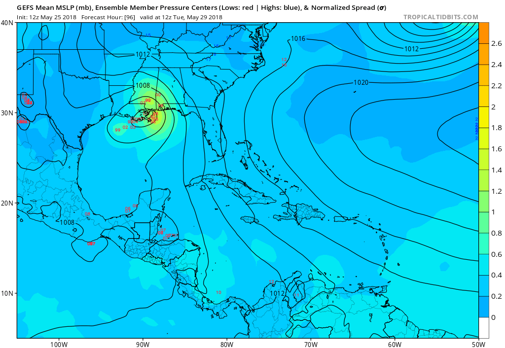
Latest GFS shows 355K PV dropping as Alberto comes ashore.
A possibility we may see a strengthening system as it makes landfall.
A possibility we may see a strengthening system as it makes landfall.
4 likes

Re: ATL: ALBERTO - Sub-Tropical Storm
i hv a question. with no llc yet for models to lock on to, i’m assuming the track is based off of the trough the ridge the atmospheric conditions. what are the chances that ukmet is right if the loc formed more east? is that possible? i know we are within 48 hours so accuracy is pretty good in that time frame. but do models lock on even without a llc to a track and be right? don’t get me wrong, i think pensacola westward is probably correct. i’m just wondering about the accuracy of models in consensus when we don’t have an llc.
0 likes
Robbielyn McCrary
I know just about enough to sound like I know what I'm talking about sometimes. But for your safety please follow the nhc for truly professional forecasting.
I know just about enough to sound like I know what I'm talking about sometimes. But for your safety please follow the nhc for truly professional forecasting.
-
Aric Dunn
- Category 5
- Posts: 21238
- Age: 43
- Joined: Sun Sep 19, 2004 9:58 pm
- Location: Ready for the Chase.
- Contact:
Re: ATL: ALBERTO - Sub-Tropical Storm
look it is pretty straightforward.. we wont see this center reformation until the right ingredients are there. and currently, we have to wait until the upper trough/low/cut off low seen in watervapor is drops to the ssw more which will put the mid level/low level vorticity in the divergent and moist side of the trough. ... which is the ne side of the negatively tilted up trough/cut off low moving south.
use the NASA link 50 images medium zoom..
http://weather.cod.edu/satrad/exper/?pa ... rbars=data
https://weather.msfc.nasa.gov/goes/abi/ ... and08.html

use the NASA link 50 images medium zoom..
http://weather.cod.edu/satrad/exper/?pa ... rbars=data
https://weather.msfc.nasa.gov/goes/abi/ ... and08.html
2 likes
Note: If I make a post that is brief. Please refer back to previous posts for the analysis or reasoning. I do not re-write/qoute what my initial post said each time.
If there is nothing before... then just ask
Space & Atmospheric Physicist, Embry-Riddle Aeronautical University,
I believe the sky is falling...
If there is nothing before... then just ask
Space & Atmospheric Physicist, Embry-Riddle Aeronautical University,
I believe the sky is falling...
-
SunnyThoughts
- Category 5
- Posts: 2263
- Joined: Wed Jul 09, 2003 12:42 pm
- Location: Pensacola, Florida

-
cycloneye

- Admin
- Posts: 149401
- Age: 69
- Joined: Thu Oct 10, 2002 10:54 am
- Location: San Juan, Puerto Rico
Re: ATL: ALBERTO - Recon
Here is Fridays TCPOD for Saturday and Sunday.
Code: Select all
WEATHER RECONNAISSANCE FLIGHTS
CARCAH, NATIONAL HURRICANE CENTER, MIAMI, FL.
1240 PM EDT FRI 25 MAY 2018
SUBJECT: TROPICAL CYCLONE PLAN OF THE DAY (TCPOD)
         VALID 26/1100Z TO 27/1100Z MAY 2018
         TCPOD NUMBER.....18-004

I.  ATLANTIC REQUIREMENTS
    1. SUBTROPICAL STORM ALBERTO
       FLIGHT ONE - TEAL 73          FLIGHT TWO - TEAL 71
       A. 26/2330Z,27/0530Z          A. 27/1130Z,1730Z
       B. AFXXX 0301A ALBERTO        B. AFXXX 0401A ALBERTO
       C. 26/2100Z                   C. 27/0930Z
       D. 24.1N 85.8W                D. 26.7N 86.1W
       E. 26/2300Z TO 27/0530Z       E. 27/1100Z TO 27/1730Z
       F. SFC TO 10,000 FT           F. SFC TO 10,000 FT

    2. OUTLOOK FOR SUCCEEDING DAY: CONTINUE 6-HRLY FIXES WHILE SYSTEM
       REMAINS A THREAT.
0 likes
Visit the Caribbean-Central America Weather Thread where you can find at first post web cams,radars
and observations from Caribbean basin members Click Here
and observations from Caribbean basin members Click Here
-
tarheelprogrammer

- S2K Supporter

- Posts: 1793
- Joined: Mon Mar 28, 2016 9:25 pm
- Location: Raleigh, NC area (Garner, NC)
Re: ATL: ALBERTO - Sub-Tropical Storm
I see a new center forming here:

0 likes
My posts are not official forecasts. They are just my opinion and may or may not be backed by sound meteorological data. They are NOT endorsed by any professional institution or storm2k.org. For official information, please refer to the NHC and NWS products.
-
gatorcane

- S2K Supporter
- Posts: 23708
- Age: 48
- Joined: Sun Mar 13, 2005 3:54 pm
- Location: Boca Raton, FL
Re: ATL: ALBERTO - Sub-Tropical Storm
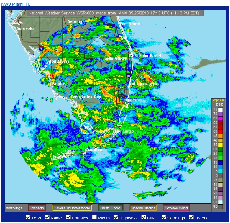
I'll admit, I didn't think the radar would be lighting up so much just yet with Alberto as the deluge on peninsula Florida has commenced...
1 likes
-
tolakram
- Admin
- Posts: 20185
- Age: 62
- Joined: Sun Aug 27, 2006 8:23 pm
- Location: Florence, KY (name is Mark)
Re: ATL: ALBERTO - Sub-Tropical Storm
COD loop: http://weather.cod.edu/satrad/exper/?parms=meso-meso1-02-200-1-100-1&checked=map&colorbars=
1 likes
M a r k
- - - - -
Join us in chat: Storm2K Chatroom Invite. Android and IOS apps also available.
The posts in this forum are NOT official forecasts and should not be used as such. Posts are NOT endorsed by any professional institution or STORM2K.org. For official information and forecasts, please refer to NHC and NWS products.
- - - - -
Join us in chat: Storm2K Chatroom Invite. Android and IOS apps also available.
The posts in this forum are NOT official forecasts and should not be used as such. Posts are NOT endorsed by any professional institution or STORM2K.org. For official information and forecasts, please refer to NHC and NWS products.
-
cycloneye
- Admin
- Posts: 149401
- Age: 69
- Joined: Thu Oct 10, 2002 10:54 am
- Location: San Juan, Puerto Rico
Re: ATL: ALBERTO - Recon
Plane is flying torwards Alberto.
URNT15 KNHC 251730
AF307 0101A ALBERTO HDOB 01 20180525
170930 3009N 08905W 7465 02628 0153 +089 +059 216005 007 /// /// 03
171000 3007N 08905W 7257 02861 0153 +076 +040 215008 009 /// /// 03
171030 3005N 08904W 7050 03099 0153 +063 +025 215008 009 /// /// 03
171100 3003N 08904W 6860 03324 0156 +046 +029 231008 008 /// /// 03
171130 3001N 08903W 6700 03518 0156 +036 +020 238007 008 /// /// 03
171200 2959N 08903W 6555 03702 0161 +025 +012 244006 007 /// /// 03
171230 2957N 08902W 6412 03881 0161 +014 +010 227007 009 /// /// 03
171300 2955N 08902W 6258 04076 0156 +005 +001 212010 010 /// /// 03
171330 2952N 08901W 6109 04270 0146 -002 -006 226009 009 /// /// 03
171400 2950N 08901W 5960 04468 0146 -013 -015 250009 010 /// /// 03
171430 2948N 08900W 5820 04657 0142 -024 -028 245007 009 /// /// 03
171500 2946N 08900W 5676 04856 0144 -036 -042 223005 006 /// /// 03
171530 2944N 08900W 5546 05040 0140 -046 -054 221004 004 /// /// 03
171600 2942N 08859W 5418 05222 0246 -055 -062 212006 009 /// /// 03
171630 2939N 08859W 5297 05400 0255 -065 -077 200009 009 /// /// 03
171700 2937N 08858W 5176 05581 0264 -075 -096 201008 010 /// /// 03
171730 2935N 08858W 5058 05762 0274 -081 -127 207007 009 /// /// 03
171800 2933N 08857W 4940 05946 0284 -090 -151 201009 009 /// /// 03
171830 2931N 08857W 4825 06128 0294 -101 -156 186009 009 /// /// 03
171900 2929N 08856W 4712 06313 0305 -112 -163 176011 011 /// /// 03
0 likes
Visit the Caribbean-Central America Weather Thread where you can find at first post web cams,radars
and observations from Caribbean basin members Click Here
and observations from Caribbean basin members Click Here
-
cycloneye
- Admin
- Posts: 149401
- Age: 69
- Joined: Thu Oct 10, 2002 10:54 am
- Location: San Juan, Puerto Rico
Re: ATL: ALBERTO - Recon
URNT15 KNHC 251734
AF307 0101A ALBERTO HDOB 02 20180525
171930 2927N 08856W 4599 06500 0317 -126 -168 181009 011 /// /// 03
172000 2925N 08856W 4537 06610 0326 -135 -181 187006 008 /// /// 03
172030 2923N 08855W 4478 06708 0330 -135 -167 208008 008 /// /// 03
172100 2921N 08855W 4461 06740 0333 -137 -175 205005 008 /// /// 03
172130 2919N 08854W 4461 06739 0332 -135 -184 202005 006 /// /// 03
172200 2917N 08854W 4461 06736 0331 -138 -178 218008 009 /// /// 03
172230 2914N 08853W 4462 06734 0330 -140 -161 226009 009 /// /// 03
172300 2912N 08853W 4461 06737 0331 -141 -155 220007 009 /// /// 03
172330 2909N 08852W 4462 06734 0332 -140 -155 233007 008 /// /// 03
172400 2907N 08851W 4461 06737 0332 -138 -168 225008 008 /// /// 03
172430 2904N 08851W 4463 06734 0332 -135 -180 230009 009 /// /// 03
172500 2902N 08850W 4462 06736 0332 -133 -175 236010 010 /// /// 03
172530 2859N 08850W 4462 06737 0333 -139 -180 220008 010 /// /// 03
172600 2856N 08849W 4463 06735 0333 -136 -175 225009 010 /// /// 03
172630 2854N 08849W 4463 06733 0332 -141 -161 229010 010 /// /// 03
172700 2851N 08848W 4463 06733 0333 -138 -165 231010 010 /// /// 03
172730 2848N 08847W 4463 06735 0333 -139 -170 227010 011 /// /// 03
172800 2845N 08847W 4464 06732 0333 -138 -167 220010 011 /// /// 03
172830 2843N 08846W 4466 06730 0333 -136 -178 225009 009 /// /// 03
172900 2840N 08846W 4461 06739 0334 -140 -182 218008 009 /// /// 03
$$
0 likes
Visit the Caribbean-Central America Weather Thread where you can find at first post web cams,radars
and observations from Caribbean basin members Click Here
and observations from Caribbean basin members Click Here
-
Aric Dunn
- Category 5
- Posts: 21238
- Age: 43
- Joined: Sun Sep 19, 2004 9:58 pm
- Location: Ready for the Chase.
- Contact:
Re: ATL: ALBERTO - Sub-Tropical Storm
anyway.. long story short from my previous post.. look off the NE tip of the Yucatan over the next several hours.
This daytime cloud phase /RGB will help differentiate between the level at which the clouds are. you can see there is nothing in the low level near or under the MLC. the next eddy/vort appears to be near cancun/ne tip of Yucantan.
http://weather.cod.edu/satrad/exper/?pa ... colorbars=
This daytime cloud phase /RGB will help differentiate between the level at which the clouds are. you can see there is nothing in the low level near or under the MLC. the next eddy/vort appears to be near cancun/ne tip of Yucantan.
http://weather.cod.edu/satrad/exper/?pa ... colorbars=
0 likes
Note: If I make a post that is brief. Please refer back to previous posts for the analysis or reasoning. I do not re-write/qoute what my initial post said each time.
If there is nothing before... then just ask
Space & Atmospheric Physicist, Embry-Riddle Aeronautical University,
I believe the sky is falling...
If there is nothing before... then just ask
Space & Atmospheric Physicist, Embry-Riddle Aeronautical University,
I believe the sky is falling...
-
alan1961

- Category 2

- Posts: 771
- Joined: Mon Mar 20, 2006 11:58 am
- Location: Derby, Derbyshire, England
- Contact:
Re: ATL: ALBERTO - Sub-Tropical Storm
Hi people
can anyone tell me whats happening with the floaters and goest east
sat imagery..its all changed and i can't seem to access it.
can anyone provide any links to alternative imagery please.
sorry if this is in the wrong thread/section and has been mention before.
Thanks
can anyone tell me whats happening with the floaters and goest east
sat imagery..its all changed and i can't seem to access it.
can anyone provide any links to alternative imagery please.
sorry if this is in the wrong thread/section and has been mention before.
Thanks
0 likes
-
cycloneye
- Admin
- Posts: 149401
- Age: 69
- Joined: Thu Oct 10, 2002 10:54 am
- Location: San Juan, Puerto Rico
Re: ATL: ALBERTO - Advisories
BULLETIN
Subtropical Storm Alberto Intermediate Advisory Number 1A
NWS National Hurricane Center Miami FL AL012018
100 PM CDT Fri May 25 2018
...ALBERTO MEANDERING OVER THE NORTHWESTERN CARIBBEAN SEA...
...HEAVY RAINFALL EXPECTED TO AFFECT THE YUCATAN PENINSULA...WESTERN
CUBA...FLORIDA...AND THE NORTHEASTERN GULF COAST THROUGH THE
WEEKEND...
SUMMARY OF 100 PM CDT...1800 UTC...INFORMATION
----------------------------------------------
LOCATION...19.5N 86.5W
ABOUT 60 MI...95 KM S OF COZUMEL MEXICO
ABOUT 200 MI...320 KM SW OF THE WESTERN TIP OF CUBA
MAXIMUM SUSTAINED WINDS...40 MPH...65 KM/H
PRESENT MOVEMENT...STATIONARY
MINIMUM CENTRAL PRESSURE...1005 MB...29.68 INCHES
WATCHES AND WARNINGS
--------------------
CHANGES WITH THIS ADVISORY:
None.
SUMMARY OF WATCHES AND WARNINGS IN EFFECT:
A Tropical Storm Watch is in effect for...
* Tulum to Cabo Catoche Mexico
* Cuban province of Pinar del Rio
A Tropical Storm Watch means that tropical storm conditions are
possible within the watch area, in this case within the next 24
hours.
Interests along the central and eastern U.S. Gulf Coast should
monitor the progress of Alberto. Tropical storm and storm surge
watches could be required for portions of this area later today or
tonight.
For storm information specific to your area, please monitor
products issued by your national meteorological service.
DISCUSSION AND OUTLOOK
----------------------
At 100 PM CDT (1800 UTC), the center of Subtropical Storm Alberto
was located near latitude 19.5 North, longitude 86.5 West. The
storm has been nearly stationary during the past several hours.
However, a general slow motion toward the north is expected through
the weekend, followed by a northwest turn by Monday. On the foreast
track, Alberto is expected to pass near the eastern coast of the
Yucatan peninsula tonight, be near the western tip of Cuba Saturday
morning, emerge over the southeastern Gulf of Mexico by Saturday
night, and approach the north-central Gulf Coast on Monday.
Maximum sustained winds are near 40 mph (65 km/h) with higher
gusts. Gradual strengthening is forecast for the next 72 hours.
Winds of 40 mph extend outward up to 115 miles (185 km) from the
center.
The estimated minimum central pressure is 1005 mb (29.68 inches).
HAZARDS AFFECTING LAND
----------------------
RAINFALL: Alberto is expected to produce total rain accumulations
of 10 to 15 inches with isolated totals of 25 inches across the
northeastern portions of the Yucatan Peninsula and western Cuba.
These rains could produce life-threatening flash floods and
mudslides. Rainfall accmumulations of 4 to 8 inches with maximum
amounts of 12 inches are possible across the Florida Keys and
southern and southwestern Florida. Heavy rain will likely begin
to affect the central Gulf Coast region and the southeastern Untied
States later this weekend and continue into early next week.
Flooding potential will increase across this region early next
week as Alberto is forecast to slow down after it moves inland.
WIND: Tropical storm conditions are possible within the watch
area through Saturday.
SURF: Swells generated by Alberto are affecting portions of
the coast of eastern Yucatan Peninsula and western Cuba. These
swells are likely to cause life-threatening surf and rip current
conditions. Hazardous surf conditions are likely to develop along
much of the central and eastern U.S. Gulf Coast this weekend. For
more information, consult products from your local weather office.
NEXT ADVISORY
-------------
Next complete advisory at 400 PM CDT.
$$
Forecaster Stewart
0 likes
Visit the Caribbean-Central America Weather Thread where you can find at first post web cams,radars
and observations from Caribbean basin members Click Here
and observations from Caribbean basin members Click Here
-
cycloneye
- Admin
- Posts: 149401
- Age: 69
- Joined: Thu Oct 10, 2002 10:54 am
- Location: San Juan, Puerto Rico
Re: ATL: ALBERTO - Sub-Tropical Storm
SUMMARY OF 100 PM CDT...1800 UTC...INFORMATION
----------------------------------------------
LOCATION...19.5N 86.5W
ABOUT 60 MI...95 KM S OF COZUMEL MEXICO
ABOUT 200 MI...320 KM SW OF THE WESTERN TIP OF CUBA
MAXIMUM SUSTAINED WINDS...40 MPH...65 KM/H
PRESENT MOVEMENT...STATIONARY
MINIMUM CENTRAL PRESSURE...1005 MB...29.68 INCHES
----------------------------------------------
LOCATION...19.5N 86.5W
ABOUT 60 MI...95 KM S OF COZUMEL MEXICO
ABOUT 200 MI...320 KM SW OF THE WESTERN TIP OF CUBA
MAXIMUM SUSTAINED WINDS...40 MPH...65 KM/H
PRESENT MOVEMENT...STATIONARY
MINIMUM CENTRAL PRESSURE...1005 MB...29.68 INCHES
0 likes
Visit the Caribbean-Central America Weather Thread where you can find at first post web cams,radars
and observations from Caribbean basin members Click Here
and observations from Caribbean basin members Click Here
-
txwatcher91
- Category 5
- Posts: 1498
- Joined: Tue Aug 02, 2005 2:29 pm
Re: ATL: ALBERTO - Sub-Tropical Storm
HMON has landfall at 971mb and HWRF 977mb, both borderline cat 1 with a large area of TS winds. Surge would be a bit of an issue for some areas if this verified and some power outages too.
0 likes
Who is online
Users browsing this forum: No registered users and 170 guests