ATL: ALBERTO - Post-Tropical
Moderator: S2k Moderators
-
Aric Dunn
- Category 5

- Posts: 21238
- Age: 43
- Joined: Sun Sep 19, 2004 9:58 pm
- Location: Ready for the Chase.
- Contact:
ATL: ALBERTO - Sub-Tropical Storm
Just a note.. the 12z Euro has initialized in the new location so this will be the first model run with new center.
1 likes
Note: If I make a post that is brief. Please refer back to previous posts for the analysis or reasoning. I do not re-write/qoute what my initial post said each time.
If there is nothing before... then just ask
Space & Atmospheric Physicist, Embry-Riddle Aeronautical University,
I believe the sky is falling...
If there is nothing before... then just ask
Space & Atmospheric Physicist, Embry-Riddle Aeronautical University,
I believe the sky is falling...
-
cycloneye

- Admin

- Posts: 149389
- Age: 69
- Joined: Thu Oct 10, 2002 10:54 am
- Location: San Juan, Puerto Rico
Re: ATL: ALBERTO - Advisories
BULLETIN
Subtropical Storm Alberto Intermediate Advisory Number 5A
NWS National Hurricane Center Miami FL AL012018
200 PM EDT Sat May 26 2018
...CENTER OF ALBERTO REFORMS OVER THE SOUTHEASTERN GULF OF MEXICO...
...BANDS OF HEAVY RAINFALL AFFECTING WESTERN CUBA AND SOUTHERN
FLORIDA...
SUMMARY OF 200 PM EDT...1800 UTC...INFORMATION
----------------------------------------------
LOCATION...22.8N 85.2W
ABOUT 65 MI...105 KM NNW OF THE WESTERN TIP OF CUBA
ABOUT 195 MI...315 KM SW OF THE DRY TORTUGAS
MAXIMUM SUSTAINED WINDS...40 MPH...65 KM/H
PRESENT MOVEMENT...N OR 360 DEGREES AT 13 MPH...20 KM/H
MINIMUM CENTRAL PRESSURE...999 MB...29.50 INCHES
WATCHES AND WARNINGS
--------------------
CHANGES WITH THIS ADVISORY:
None
SUMMARY OF WATCHES AND WARNINGS IN EFFECT:
A Storm Surge Watch is in effect for...
* Crystal River to the Mouth of the Mississippi River
A Tropical Storm Warning is in effect for...
* Cuban province of Pinar del Rio
* Dry Tortugas
A Tropical Storm Watch is in effect for...
* Boca Grande to Anclote River
* Aucilla River to Grand Isle
* Lake Pontchartrain and Lake Maurepas
A Storm Surge Watch means there is a possibility of life-
threatening inundation, from rising water moving inland from the
coastline, in the indicated locations during the next 48 hours.
For a depiction of areas at risk, please see the National Weather
Service Storm Surge Watch/Warning Graphic, available at
hurricanes.gov.
A Tropical Storm Warning means that tropical storm conditions are
expected somewhere within the warning area, in this case within
the next 24 hours.
A Tropical Storm Watch means that tropical storm conditions are
possible in the United States portion of that watch area within
48 hours.
For storm information specific to your area in the United
States, including possible inland watches and warnings, please
monitor products issued by your local National Weather Service
forecast office. For storm information specific to your area outside
the United States, please monitor products issued by your national
meteorological service.
DISCUSSION AND OUTLOOK
----------------------
At 200 PM EDT (1800 UTC), the center of Subtropical Storm Alberto
was located by reconnaissance aircraft and satellite data near
latitude 22.8 North, longitude 85.2 West. The storm is moving
toward the north near 13 mph (20 km/h). A northward or
north-northeastward motion is expected today, followed by a slower
north-northwestward motion on Sunday and Monday. On the forecast
track, the center of Alberto is forecast to move over the eastern
Gulf of Mexico tonight through Monday, and approach the northern
Gulf Coast in the watch area late Monday or Monday night. Heavy
rainfall and tropical storm conditions will likely reach the
northern Gulf Coast well before the arrival of the center of
Alberto.
Maximum sustained winds are near 40 mph (65 km/h) with higher
gusts. Gradual strengthening is forecast until the system reaches
the northern Gulf Coast by Monday night.
Winds of 40 mph extend outward up to 140 miles (220 km) mainly to
the east of the center.
The estimated minimum central pressure based on data from an Air
Force Reserve reconnaissance aircraft is 999 mb (29.50 inches).
HAZARDS AFFECTING LAND
----------------------
RAINFALL: Alberto is expected to produce total rain accumulations
of 10 to 15 inches with isolated totals of 25 inches across western
Cuba. These rains could produce life-threatening flash floods and
mudslides. Rainfall accumulations of 3 to 7 inches with maximum
amounts of 10 inches are possible across the Florida Keys and
southern and southwest Florida. Heavy rains will begin to affect
the central Gulf Coast region into the southeastern United States on
Sunday and continue into the middle of next week as Alberto moves
northward after landfall. Rainfall totals of 5 to 10 inches with
maximum amounts of 15 inches are possible along the track of Alberto
from eastern Louisiana, across much of Mississippi, Alabama, western
Tennessee and the western Florida panhandle. Rainfall totals of 3
to 5 inches with maximum totals of 8 inches possible from the
southern Appalachians into the coastal southeast.
WIND: Tropical storm conditions are expected within portions of the
warning area in Cuba through this evening. Tropical storm
conditions are expected in the Dry Tortugas through tonight.
Tropical storm conditions are possible in the watch area along the
Florida west coast on Sunday, and along the northern Gulf Coast
by Sunday night or early Monday.
STORM SURGE: The combination of storm surge and the tide will cause
normally dry areas near the coast to be flooded by rising waters
moving inland from the shoreline. The water could reach the
following heights above ground somewhere in the indicated
areas if the peak surge occurs at the time of high tide...
Crystal River to the Mouth of the Mississippi River...2 to 4 ft
The deepest water will occur along the immediate coast. Surge-
related flooding depends on the relative timing of the surge
and the tidal cycle, and can vary greatly over short distances. For
information specific to your area, please see products issued by
your local National Weather Service forecast office.
TORNADOES: A tornado or two may occur over the Florida Keys and
parts of southwestern Florida late this afternoon through tonight.
SURF: Swells generated by Alberto are affecting portions of the
coast of eastern Yucatan Peninsula and western Cuba. These swells
are likely to cause life-threatening surf and rip current
conditions. Hazardous surf conditions are likely to develop along
much of the central and eastern U.S. Gulf Coast through the weekend.
For more information, consult products from your local weather
office.
NEXT ADVISORY
-------------
Next complete advisory at 500 PM EDT.
$$
Forecaster Brown
0 likes
Visit the Caribbean-Central America Weather Thread where you can find at first post web cams,radars
and observations from Caribbean basin members Click Here
and observations from Caribbean basin members Click Here
-
cycloneye
- Admin
- Posts: 149389
- Age: 69
- Joined: Thu Oct 10, 2002 10:54 am
- Location: San Juan, Puerto Rico
Re: ATL: ALBERTO - Sub-Tropical Storm
...CENTER OF ALBERTO REFORMS OVER THE SOUTHEASTERN GULF OF MEXICO...
...BANDS OF HEAVY RAINFALL AFFECTING WESTERN CUBA AND SOUTHERN
FLORIDA...
SUMMARY OF 200 PM EDT...1800 UTC...INFORMATION
----------------------------------------------
LOCATION...22.8N 85.2W
ABOUT 65 MI...105 KM NNW OF THE WESTERN TIP OF CUBA
ABOUT 195 MI...315 KM SW OF THE DRY TORTUGAS
MAXIMUM SUSTAINED WINDS...40 MPH...65 KM/H
PRESENT MOVEMENT...N OR 360 DEGREES AT 13 MPH...20 KM/H
MINIMUM CENTRAL PRESSURE...999 MB...29.50 INCHES
0 likes
Visit the Caribbean-Central America Weather Thread where you can find at first post web cams,radars
and observations from Caribbean basin members Click Here
and observations from Caribbean basin members Click Here
Re: ATL: ALBERTO - Sub-Tropical Storm
I wonder what the rain totals are like over western Cuba..they have been getting hosed for days
1 likes
-
rolltide

- Tropical Storm

- Posts: 234
- Age: 65
- Joined: Thu Sep 09, 2004 5:33 pm
- Location: Pensacola Florida
Re: ATL: ALBERTO - Models
Those wobbles in the track on the GFS could make it interesting trying to figure out just where it will make landfall. 20 miles east or west could make a huge difference to us here in Pensacola.
1 likes

Re: ATL: ALBERTO - Sub-Tropical Storm
They're still calling it a SS. Probably waiting until 5pm just to make sure the transition is complete.
1 likes
Igor 2010, Sandy 2012, Fay 2014, Gonzalo 2014, Joaquin 2015, Nicole 2016, Humberto 2019, Imelda 2025
I am only a tropical weather enthusiast. My predictions are not official and may or may not be backed by sound meteorological data. For official information, please refer to the NHC and NWS products.
I am only a tropical weather enthusiast. My predictions are not official and may or may not be backed by sound meteorological data. For official information, please refer to the NHC and NWS products.
-
Ivanhater

- Storm2k Moderator

- Posts: 11221
- Age: 39
- Joined: Fri Jul 01, 2005 8:25 am
- Location: Pensacola
Re: ATL: ALBERTO - Models
rolltide wrote:Those wobbles in the track on the GFS could make it interesting trying to figure out just where it will make landfall. 20 miles east or west could make a huge difference to us here in Pensacola.
That likely won't been known until a few hours before landfall based on the trajectory and curve before landfall
0 likes
Michael
-
gatorcane

- S2K Supporter

- Posts: 23708
- Age: 48
- Joined: Sun Mar 13, 2005 3:54 pm
- Location: Boca Raton, FL
Re: ATL: ALBERTO - Models
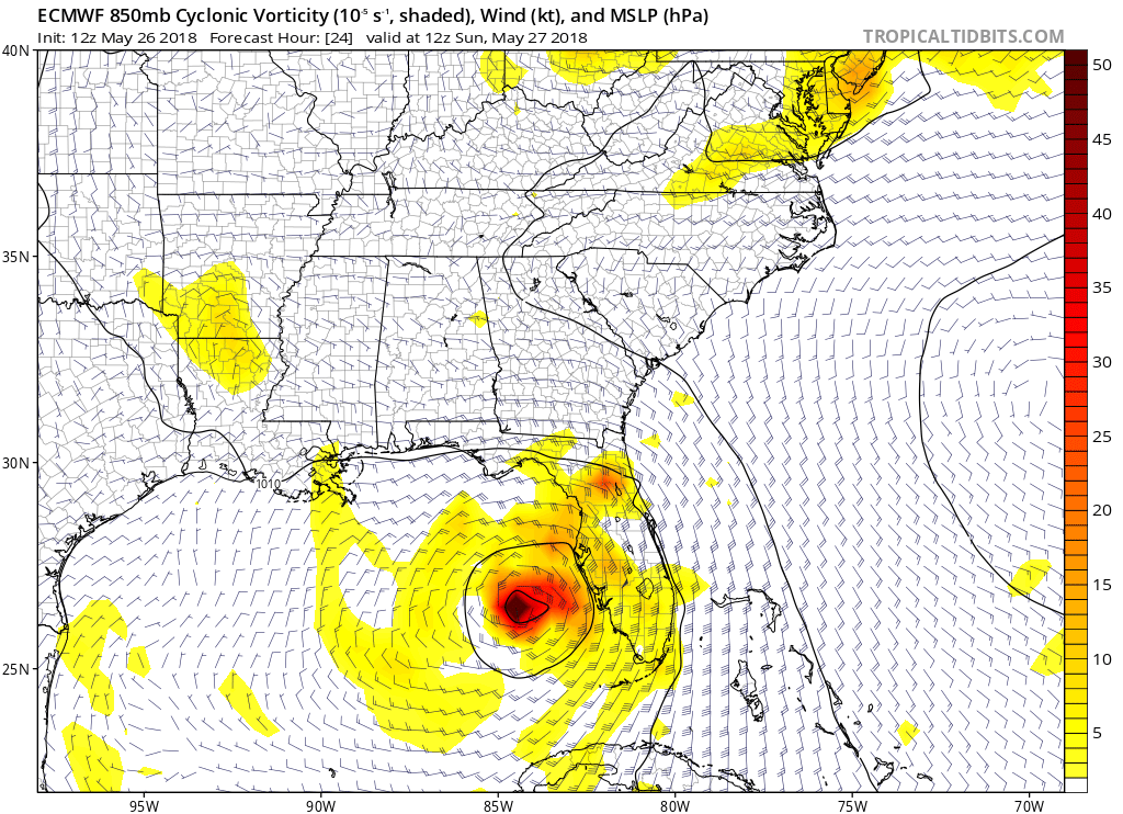
12Z Euro 24 hours. Wow that is the farthest east the model has been yet:
1 likes

-
Dean4Storms
- S2K Supporter
- Posts: 6358
- Age: 63
- Joined: Sun Aug 31, 2003 1:01 pm
- Location: Miramar Bch. FL
Re: ATL: ALBERTO - Models
ECM with 60mph wind gusts by late tonight east of the center. Midway between the center and Key West! 
0 likes
-
MGC

- S2K Supporter
- Posts: 5940
- Joined: Sun Mar 23, 2003 9:05 pm
- Location: Pass Christian MS, or what is left.
Re: ATL: ALBERTO - Sub-Tropical Storm
With the new center forming, I think the threat to the Florida Peninsula has increased. Looking more tropical with the convection located near the center. Appears to be becoming better organized. Interesting what next recon mission reveals......MGC
2 likes
Re: ATL: ALBERTO - Models
SFLcane wrote:Woah there on the 12z ECMWF riding along Florida’s west coast
in line with ukmet
0 likes
Robbielyn McCrary
I know just about enough to sound like I know what I'm talking about sometimes. But for your safety please follow the nhc for truly professional forecasting.
I know just about enough to sound like I know what I'm talking about sometimes. But for your safety please follow the nhc for truly professional forecasting.
-
Frank P
- S2K Supporter
- Posts: 2779
- Joined: Fri Aug 29, 2003 10:52 am
- Location: Biloxi Beach, Ms
- Contact:
Re: ATL: ALBERTO - Models
SFLcane wrote:Woah there on the 12z ECMWF riding along Florida’s west coast
And that is a big jump to the NNE/NE... now the center is moving north at 13, so it better start showing that NE motion soon if this run is to come to fruition... something to watch for on the sat loops..
0 likes
-
tolakram
- Admin
- Posts: 20185
- Age: 62
- Joined: Sun Aug 27, 2006 8:23 pm
- Location: Florence, KY (name is Mark)
Re: ATL: ALBERTO - Models

0 likes
M a r k
- - - - -
Join us in chat: Storm2K Chatroom Invite. Android and IOS apps also available.
The posts in this forum are NOT official forecasts and should not be used as such. Posts are NOT endorsed by any professional institution or STORM2K.org. For official information and forecasts, please refer to NHC and NWS products.
-
Dean4Storms
- S2K Supporter
- Posts: 6358
- Age: 63
- Joined: Sun Aug 31, 2003 1:01 pm
- Location: Miramar Bch. FL
Re: ATL: ALBERTO - Models
ECM in 24hrs with gusts to 50mph east and west coasts of southern half of FL!
0 likes
Re: ATL: ALBERTO - Sub-Tropical Storm
Best news on that 2 pm update is the forward motion of 13mph.
1 likes
-
tolakram
- Admin
- Posts: 20185
- Age: 62
- Joined: Sun Aug 27, 2006 8:23 pm
- Location: Florence, KY (name is Mark)
Re: ATL: ALBERTO - Models

0 likes
M a r k
- - - - -
Join us in chat: Storm2K Chatroom Invite. Android and IOS apps also available.
The posts in this forum are NOT official forecasts and should not be used as such. Posts are NOT endorsed by any professional institution or STORM2K.org. For official information and forecasts, please refer to NHC and NWS products.
- - - - -
Join us in chat: Storm2K Chatroom Invite. Android and IOS apps also available.
The posts in this forum are NOT official forecasts and should not be used as such. Posts are NOT endorsed by any professional institution or STORM2K.org. For official information and forecasts, please refer to NHC and NWS products.
-
gatorcane
- S2K Supporter
- Posts: 23708
- Age: 48
- Joined: Sun Mar 13, 2005 3:54 pm
- Location: Boca Raton, FL
Re: ATL: ALBERTO - Models
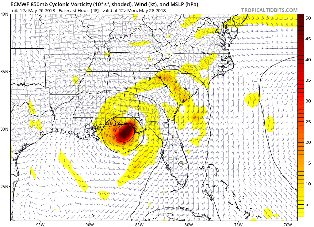
12Z Euro panhandle hit:
Last edited by gatorcane on Sat May 26, 2018 1:01 pm, edited 1 time in total.
0 likes
-
Ivanhater
- Storm2k Moderator
- Posts: 11221
- Age: 39
- Joined: Fri Jul 01, 2005 8:25 am
- Location: Pensacola
Re: ATL: ALBERTO - Models
Getting shoved toward extreme NW Florida by the high building in from the east
0 likes
Michael
Who is online
Users browsing this forum: No registered users and 44 guests